Lighthouses of Japan: Ibaraki

The nation of Japan, known in Japanese as Nihon or Nippon (日本), occupies an archipelago off the east coast of Asia. The four main islands are Hokkaidō in the north, Honshū (the largest) in the center, Shikoku in the south, and Kyūshū in the southwest. The country includes thousands of other islands of all sizes; among them the Ryūkyū (Nansei) Islands are a long chain extending to the southwest and including the large island of Okinawa, and the Nanpō Islands are another long chain extending south into the Pacific Ocean. Much of Japan is mountainous but the coastal regions are densely populated and urbanized; the country's population is about 126 million.

Japan is divided into 47 prefectures. This page lists lighthouses of Ibaraki prefecture, located on the east coast of Honshū within a short drive of the Tōkyō metropolitan area. Ibaraki prefecture faces east on the open Pacific Ocean; its coast is relatively low except for the prominent capes of Ōtsu Saki in the north and Iso Saki in the center of the prefecture.

In Japanese the word for a lighthouse is tōdai or toudai (灯台). The words saki and misaki are for capes and headlands, hana ("nose") is a promontory, hantō is a peninsula, shima (also spelled sima or jima) is an island, bae is a reef, iwa or shi is a rocky reef, amase or se is a shoal, wan is a bay, nada is a sound or basin, kaikyō is a strait, kawa is a river, and or minato is a harbor.

Lighthouses in Japan are operated and maintained by the Japanese Coast Guard's Maritime Safety Agency. On Honshū there is usually one Coast Guard Section Office in each prefecture, sometimes two. The Ibaraki Coast Guard office is located in Hitachinaka.

ARLHS numbers are from the ARLHS World List of Lights. JCG numbers are the Japanese Coast Guard's light list numbers. Admiralty numbers are from volume M of the Admiralty List of Lights & Fog Signals. U.S. NGA List numbers are from Publication 112.

General Sources
Lighthouses in Japan - Ibaraki
A site providing photos and data for most major Japanese lighthouses.
Lighthouse-Japan.com - Ibaraki
Another comprehensive site with photos and notes from visits to many lighthouses.
Misty's Japanese Lighthouse Tour - Ibaraki
Photos and a few notes for lighthouses in all parts of the country.
Form of a Lighthouse - Ibaraki
This site has photos from recent visits with notes about access; it is cited below as FOAL (Form of a Lighthouse).
Lighthouse Visits
This site has photos for many lighthouses in this area.
Lighthouses in Ibaraki Prefecture
Photos by various photographers available from Wikimedia.
Online List of Lights - Japan
Photos posted by Alexander Trabas.
Leuchttürme Japans und Koreas auf historischen Postkarten
Historic postcard images posted by Klaus Huelse.
Navionics Charts
Navigation chart for Ibaraki.


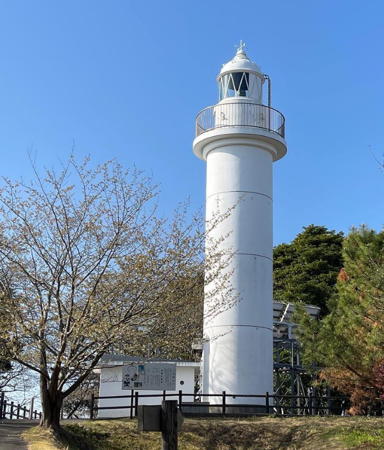
Ōtsu Misaki Light, Kitaibaraki, April 2018
ex-Google Plus photo by 木ネ申イ建

Kitaibaraki (Ibaraki City) Lighthouse
* Ōtsu Misaki
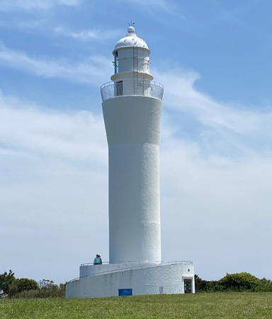
1960. Active; focal plane 56 m (184 ft); white flash every 8 s. 17 m (56 ft) round cylindrical concrete tower with lantern and gallery, rising from a 1-story keeper's house now used as a communications facility. Entire lighthouse is white. A closeup photo is at the top of this page, LighthouseJapan.com has good photos, FOAL's page has photos, Trabas has a closeup photo, a 2021 photo is available, and Google has a street view and a satellite view. There was an extensive restoration of the lighthouse in 2011 following the 3/11 earthquake. Located on a sharp promontory about 7 km (4.5 mi) northeast of Kitaibaraki. Accessible by road; parking provided. Site open, tower closed. . ARLHS JPN-471; JCG-1827; Admiralty M6496.6; NGA 4660.

Hitachi City Lighthouses
* Kawaziri (Kawajiri) (2)
1951. Active; focal plane 48 m (157 ft); white light, 3 s on, 3 s off. 17 m (56 ft) round cylindrical concrete tower. Entire lighthouse is white. Lighthouses of Japan has a photo at the top of the page; the photo at the bottom of the page is of another Kawaziri lighthouse in Yamaguchi Prefecture. Trabas has a closeup photo, a 2021 photo is available, FOAL's page has photos, Misty's Tour has two photos, and Google has a satellite view. Located on a bluff about 8 km (5 mi) north of Hitachi. Accessible by a trail from a parking area adjacent to the harbor, but the entrance is not marked. Site open, tower closed. . ARLHS JPN-251; JCG-1829; Admiralty M6496.3; NGA 4668.
* Kawaziri (Kawajiri) South Breakwater
1979. Active; focal plane 15 m (49 ft); continuous green light with a more intense flash every 3 s. 11 m (36 ft) concrete post attached to a square 1-story concrete equipment shelter. Entire lighthouse is white. Trabas has a closeup photo, FOAL's page has photos (near the bottom of the page) and Google has a street view and a satellite view. Located at the end of the south (main) breakwater of Kawaziri port. Accessible by walking the pier. Site open, tower closed. ARLHS JPN-1382; JCG-1830; Admiralty M6496.2 NGA 4672.
* Kobochi Hana (Hitachi)
1967. Active; focal plane 42 m (138 ft); three white flashes every 25 s. 25 m (82 ft) round concrete tower with a flared top, lantern and gallery. Entire lighthouse is white. Janet Myojo has the 2022 photo at right, Hiroshi Ishii has a photo, Trabas has a photo, Lighthouse-Japan.com has excellent photos, FOAL's page for the lighthouse has excellent photos, Misty's Tour also has a photo, and Google has a closeup street view and a good satellite view. Located on a promontory in a Kobochi Park on the south side of the city of Hitachi, north of the commercial harbor. Parking provided. Site open, tower closed. . ARLHS JPN-127; JCG-1833; Admiralty M6495.8; NGA 4688.
* Hitachi North Breakwater (Kuji Kō)
1959. Active; focal plane 13 m (43 ft); red flash every 3 s. 9.5 m (31 ft) concrete post attached to the square 1-story concrete equipment shelter. Entire lighthouse is red. Trabas has a photo, FOAL's page for the lighthouse has several photos, and Google has a satellite view and a distant street view. Located at the end of the main breakwater of the Kuji fishing port, at the north end of the Hitachi waterfront. Accessible by walking the pier. Site open, tower closed. ARLHS JPN-1384; JCG-1835; Admiralty M6495.9; NGA 4684.
Hitachi West Breakwater
Date unknown. Active; focal plane 19 m (62 ft); two green flashes every 7 s. 16 m (52 ft) white concrete tower with lantern and gallery. Trabas has a photo, FOAL has a page for the two breakwater lighthouses, and Google has a satellite view. Located at the end of the breakwater on the southwest side of Hitachi harbor. Site and tower closed. ARLHS JPN-1375; JCG-1835.5; Admiralty M6496; NGA 4692.

Kobochi Hana Light, Hitachi, JFebruary 2022
Google Maps photo by Janet Myojo
Hitachi Southeast Breakwater (2?)
2015 (station establishment date unknown). Active; focal plane 18 m (59 ft); red flash every 6 s. 16 m (52 ft) red concrete tower with lantern and gallery. Trabas has a photo, FOAL has a page for the two breakwater lighthouses, and Google has a satellite view. In 2015 the light was relocated to the south end of a new breakwater southeast of the old one; it's not clear if the old tower was moved or a new one was built. Located at the end of a detached breakwater on the east side of Hitachi harbor. Accessible only by boat. Site and tower closed. ARLHS JPN-1376; JCG-1836; Admiralty M6496.03; NGA 4696.
Tōkai Nuclear Plant North Breakwater
Date unknown. Active; focal plane 14 m (46 ft); red flash every 4 s. 10 m (33 ft) round hourglass-shaped concrete tower. Entire lighthouse is red. Trabas has a photo, FOAL's page has photos, and Google has a good satellite view. The Tōkai Nuclear Power Plant is Japan's oldest; one of its reactors was decommissioned in 1998, while the other was shut down following the 2011 tsunami and probably will not be restarted. Site and tower closed. ARLHS JPN-1392; JCG-1837; Admiralty M6496.02; NGA 4700.

Hitachinaka City Lighthouses
* Iso Saki
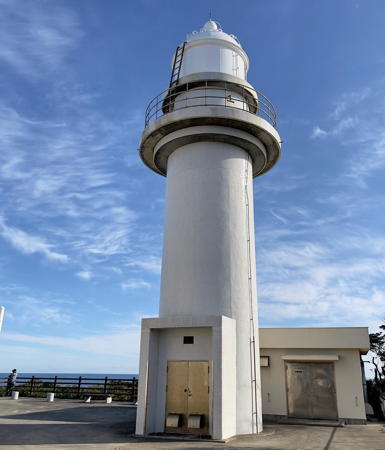
1951. Active; focal plane 36 m (118 ft); white flash every 12 s. 14 m (46 ft) round concrete tower with lantern and gallery, attached to a 1-story keeper's house. Entire lighthouse is white. FOAL's page for the lighthouse has several excellent photos, Lighthouse-Japan.com has good photos, Trabas has a closeup photo, a 2021 photo is available, Misty's Tour has a nighttime photo, and Google has a street view and a satellite view. Located on a promontory jutting into the Pacific about 15 km (9 mi) south of Hitachi, near Katsuta. Accessible by road; parking available nearby. Site open, tower closed. . ARLHS JPN-182; JCG-1839; Admiralty M6495.5; NGA 4704.
Iso Saki Light
Iso Saki Light, Hitachinaka
Japanese Coast Guard Ibaraki Office photo
Nakaminato Kō
Date unknown. Active; focal plane 14 m (46 ft); red flash every 3 s. 11 m (36 ft) round concrete tower with a flared top. Entire lighthouse is red. Trabas has a closeup photo, FOAL's page has a photo (halfway down the page) and Google has a satellite view. Located at the south end of a detached breakwater protecting the entrance to the harbor of Nakaminato. Accessible only by boat. Site open, tower closed. ARLHS JPN-1386; JCG-1840; Admiralty M6495.4; NGA 4728.
Nakaminato South Breakwater (2?)
Date unknown. Active; focal plane 14 m (46 ft); two green flashes every 9 s. 8.5 m (28 ft) concrete post attached to a square 1-story concrete equipment room. Entire lighthouse is white. Trabas has a closeup photo, FOAL's page has photos (halfway down the page), Y. O-sam has a 2021 photo, and Google has a satellite view and a distant street view. NGA lists a skeletal tower. Located at the end of the detached south breakwater of Nakaminato. Accessible only by boat. Site open, tower closed. JCG-1842; Admiralty M6495.3; NGA 4708.

Ōarai Town Lighthouses
* Ōarai Misaki
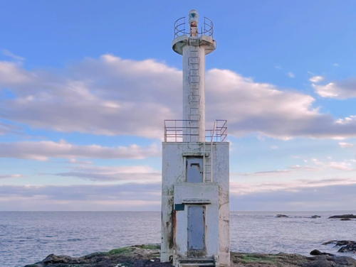
1949. Inactive since 2013. Approx. 10 m (33 ft) concrete post attached to a square 1-story concrete equipment room. Entire lighthouse is white. A photo is at right, Wikimedia has a 2010 photo, and Google has a street view and a satellite view. The photo at right, FOAL's April 2019 photos, and a 2022 photo show that the light was not removed after deactivation, but it is obviously endangered by sea level rise. Located on the beach in front of the Oarai Hotel on the east side of Ōarai harbor. Site open, tower closed. . ex-JCG-1843; ex-Admiralty M6494.2.

Ōarai Misaki Light, Ōarai, July 2016
Flickr Creative Commons photo by hkflc
Ōarai Kō South Breakwater (2)
Date unknown (station established 1984). Active; focal plane 13 m (43 ft); red flash every 4 s. 11 m (36 ft) round concrete tower, flared at the top, attached to a square 1-story concrete equipment room. Entire lighthouse is red. Trabas has a photo, FOAL's page has February 2013 photos (lower half of the page) and Google has a satellite view. Located at the end of the detached outer breakwater of Ōarai harbor. Accessible only by boat. Site status unknown. JCG-1846.5; Admiralty M6494.2; NGA 4732.

Kashima City Lighthouses
* Kashima
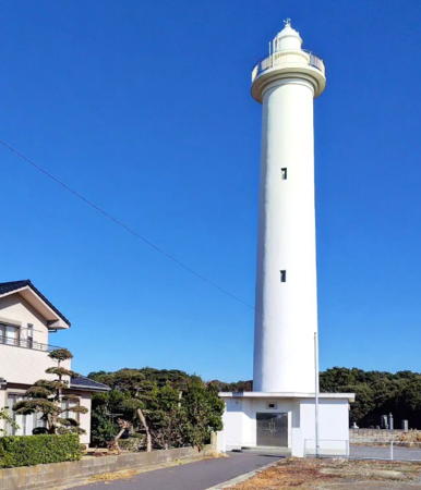
1971. Active; focal plane 63 m (207 ft); white flash every 5 s. 32 m (105 ft) round concrete tower with lantern and gallery, attached to a 1-story equipment shelter. Entire lighthouse is white. Yasuo Igarashi's photo is at right, FOAL's page for the lighthouse has numerous photos, Lighthouse-Japan.com has excellent photos, Trabas has a photo, a 2022 photo is available, Misty's Tour has a small photo, and Google has a satellite view. Google's February 2020 street view shows the lighthouse under restoration. Located on high ground in the Oritsu neighborhood, about 1 km (0.6 mi) from the coast and about 5 km (3 mi) north of Kashima harbor. Accessible by road; parking available. Site open, tower closed. . ARLHS JPN-236; JCG-1848; Admiralty M6493.2; NGA 4740.
Kashima Kō (Leading Light)
Date unknown. Active; focal plane 17 m (56 ft); white, red or green light depending on direction, continuous with a brighter light 2 s on, 2 s off. 16 m (52 ft) square cylindrical concrete tower with a larger lantern room, painted with red and white horizontal bands. Lighthouse-Japan.com has an excellent photo, Trabas has a photo, FOAL's page has additional photos, Misty's Tour has a good photo, and Google has a satellite view. White light is shown northeast over the entrance channel. Located on the waterfront of Kashima harbor. The lighthouse is in an industrial area and the Lighthouse of Japan webmaster says he used "illegal means" to get close to it. Site and tower closed. ARLHS JPN-238; JCG-1848.5; Admiralty M6492.4; NGA 4741.
Kashima South Breakwater (2)
2014 (station establishment date unknown). Active; focal plane 16 m (52 ft); white flash every 3 s. 11 m (36 ft) square pyramidal skeletal tower painted white. Google has an indistinct satellite view. The original light, an 11 m (36 ft) square white concrete tower, was destroyed by the great tsunami of 11 March 2011. The present light was installed in April 2014. Facing northeast (toward the earthquake epicenter), Kashima harbor was vulnerable to the great waves. Located about 250 m (820 ft) from the end of the long south breakwater at Kashima. JCG-1849; Admiralty M6492; NGA 4744.
* Kashima Kō Range Front
Date unknown. Active; focal plane 25 m (82 ft); continuous green light. 22 m (72 ft) round cylindrical white concrete tower. No lantern. A 2016 closeup photo is available, Lighthouse of Japan has a good photo, Trabas has a closeup photo, FOAL's page for the range lights has additional photos, and Google has a street view and a satellite view. This range guides ships into a large new artificial harbor excavated from low-lying land on the south side of Kashima by Sumitomo Metals Group. Located on the south side of the entrance to the harbor. Site open, tower closed. ARLHS JPN-1378; JCG-1851; Admiralty M6491.4; NGA 4750.

Kashima Light, Kashima, June 2018
ex-Google Plus photo by Yasuo Igarashi
* Kashima Kō Range Rear
Date unknown. Active; focal plane 31 m (102 ft); continuous green light. 27 m (89 ft) round cylindrical white concrete tower. No lantern. LighthouseJapan.com has photos, Trabas has a photo, FOAL's page for the range lights has additional photos, and Google has a street view and a satellite view. Located on the south side of the entrance to the harbor, 200 m (650 ft) south of the front light. Site and tower closed but the light can be seen from nearby. ARLHS JPN-1379; JCG-1852; Admiralty M6491.41; NGA 4750.1.

Information available on lost lighthouses:

Notable faux lighthouses:

Adjoining pages: North: Fukushima | South: Chiba

Return to the Lighthouse Directory index | Ratings key

Posted September 25, 2006. Checked and revised June 28, 2023. Lighthouses: 18. Site copyright 2023 Russ Rowlett and the University of North Carolina at Chapel Hill.