Lighthouses of Japan: Eastern Shizuoka

The nation of Japan, known in Japanese as Nihon or Nippon (日本), occupies an archipelago off the east coast of Asia. The four main islands are Hokkaidō in the north, Honshū (the largest) in the center, Shikoku in the south, and Kyūshū in the southwest. The country includes thousands of other islands of all sizes; among them the Ryūkyū (Nansei) Islands are a long chain extending to the southwest and including the large island of Okinawa, and the Nanpō Islands are another long chain extending south into the Pacific Ocean. Much of Japan is mountainous but the coastal regions are densely populated and urbanized; the country's population is about 126 million.

Japan is divided into 47 prefectures. This page lists lighthouses of the eastern half of the prefecture of Shizuoka, which faces south on the Pacific Ocean southwest of Tokyo. Shizuoka Prefecture includes some of Japan's best known and most scenic coastlines; the arrowhead-shaped Izu Peninsula shelters Suruga Bay with the famous cone of Mount Fuji on the northern horizon.

In Japanese the word for a lighthouse is tōdai or toudai (灯台). The words saki and misaki are for capes and headlands, hana ("nose") is a promontory, hantō is a peninsula, shima (also spelled sima or jima) is an island, bae is a reef, iwa or shi is a rocky reef, amase or se is a shoal, wan is a bay, nada is a sound or basin, kaikyō is a strait, kawa is a river, and or minato is a harbor.

Lighthouses in Japan are operated and maintained by the Japanese Coast Guard's Maritime Safety Agency. On Honshū there is usually one Coast Guard Section Office in each prefecture, sometimes two. Shizuoka has two Coast Guard offices: at Shimoda on the Izu Peninsula and at Shimizu on Suruga Bay. This page describes the lighthouses of the Shimoda Coast Guard District, including most of the Izu Peninsula. The Western Shizuoka page includes the lighthouses of the Shimizu Coast Guard District.

ARLHS numbers are from the ARLHS World List of Lights. JCG numbers are the Japanese Coast Guard's light list numbers. Admiralty numbers are from volume M of the Admiralty List of Lights & Fog Signals. U.S. NGA List numbers are from Publication 112.

General Sources
Lighthouses in Japan - Shizuoka
A site providing photos and data for most major Japanese lighthouses.
Lighthouse-Japan.com - Shizuoka
Another comprehensive site with photos and notes from visits to many lighthouses.
Form of a Lighthouse - Shizuoka
Another site with many photos of Japanese lighthouses, cited below as FOAL.
Misty's Japanese Lighthouse Tour -Shizuoka
Photos and a few notes for lighthouses in all parts of the country.
Online List of Lights - Japan
Photos posted by Alexander Trabas.
Lighthouses in Shizuoka Prefecture
Photos by various photographers available from Wikimedia.
Japan: Modern Lighthouses
Historic postcard images posted by Michel Forand.
Navionics Charts
Navigation chart for Shizuoka.

Irō Saki Light
Open house at Irō Saki Light, 7 November 2010
Japanese Coast Guard Shimoda Office photo

Atami City Lighthouses
Atami is a city of about 37,000 residents facing Sagami Bay at the base of Izu Peninsula. Built on the slopes of a partially submerged volcanic caldera the city is known for its many hot springs.
* Atami Breakwater
1976. Active; focal plane 15 m (49 ft); continuous green light with two more intense flashes every 7 s. 11 m (36 ft) round, slightly flared white concrete tower attached to a small 1-story equipment room. Trabas has a closeup photo, FOAL has a photo, Matsumoto-pota Masa has a photo, Ryo Matsui has a street view, and Google has a satellite view. Located at the end of the main breakwater at Atami. Accessible by walking the pier. ARLHS JPN-1424; JCG-2424; Admiralty M6314; NGA 5432.
* Aziro Breakwater
1981. Active; focal plane 13 m (43 ft); continuous green light with a more intense flash every 3 s. 9 m (30 ft) concrete post light attached to a square 1-story concrete equipment room. Entire lighthouse is white. Trabas has a closeup photo, FOAL's page has photos, and Google has a street view and a satellite view. Aziro is a small port on Sagami Bay at the northeastern corner of the Izu Peninsula, about 7 km (4.5 mi) south of Atami. Located at the end of the main breakwater at Aziro. Accessible by walking the pier. ARLHS JPN-197; JCG-2426; Admiralty M6311; NGA 5440.
#Aziro (Ajiro, Izu Aziro)
1956. Inactive since 2009 and demolished soon after. This was a 10 m (33 ft) square concrete tower mounted on a square 1-story concrete equipment room. Entire lighthouse is white. Lighthouse-Japan.com has photos taken in 2007 but Google's satellite view confirms that the lighthouse has been removed. The light had a focal plane of 43 m (141 ft) but was probably too far from the water to be useful for navigation. Located on a hilltop above the port. Site open, tower closed. ARLHS JPN-1423; ex-JCG-2427; ex-Admiralty M6310; ex-NGA 5436.
**** Hatsushima (Hatsu Shima, Hatu Sima)
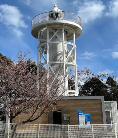
1959. Active; focal plane 63 m (207 ft); flash every 10 s, alternately red and green. 15 m (49 ft) round cylindrical concrete tower with lantern and gallery, rising from a 1-story brick building. Sometime before 2010 the lighthouse was surrounded by a spiral stairway leading to an observation platform, as seen in the photo at rightt, and a small museum was installed in the building. Lighthouse painted white; equipment building is unpainted brick with white trim. Lighthouses-Japan.com has a page with good photos, FOAL's page for the lighthouse has photos, Trabas has a distant view, a 2019 photo is avalable, Zuo Zongsheng has a 2023 photo, and Google has a street view and a satellite view. Kazu Tsuji has a photo of a Fresnel lens displayed in the nuseum. Hatsushima is a small island in the western entrance to Sagami Bay about 8 km (5 mi) east southeast of Aziro. A popular resort, the island is accessible by passenger ferry from Atami. Located on the highest point of the island, accessible by hiking or bicycle (the Coast Guard says it is a 10-minute walk to the station). The island is accessible by fast ferries from Atami. Site open, and visitors can climb the spiral stairway to the observation deck. Site manager: Hatsushima Lighthouse Museum . ARLHS JPN-093; JCG-2425; Admiralty M6309; NGA 5444.

Hatsushima Light, Atami, February 2018
ex-Google Plus photo by ちんえー

Itō City Lighthouses
Itō is a city of about 68,000 residents occupying the northeastern shoulder of the Izu Peninsula about 25 km (15 mi) southeast of Atami.
* Itō Kō East Breakwater
Date unknown. Active; focal plane 12 m (39 ft); green light, 2 s on, 2 s off. 10 m (33 ft) round cylindrical white concrete tower, attached to a small 1-story concrete equipment room. Trabas has a closeup photo, FOAL has another photo (lower right on the page), and Google has a satellite view and a closeup street view. Located at the end of the main breakwater of Itō. Accessible by walking the pier. ARLHS JPN-1430; JCG-2430; Admiralty M6306; ex-NGA 5452.
* Kawana Saki
1957. Active; focal plane 54 m (177 ft); white light, 2 s on, 2 s off. 13 m (43 ft) triangular skeletal tower with lantern and gallery, painted white. Lighthouse-Japan.com has excellent photos, Trabas has a closeup, Yukihiro Matsumura has a 2023 photo, a 2018 closeup and a 2020 drone view are available, FOAL has a photo (bottom of the page), and Google has a satellite view. This lighthouse has an unusual modern design quite unlike traditional skeletal towers. It is built on a prominent cape adjacent to a famous seaside golf course about 5 km (3 mi) southeast of Itō; Tomoaki Yamada has a nice view taken across the course. Site open, tower closed. Site manager: Kawana Hotel Golf Course. . ARLHS JPN-249; JCG-2433; Admiralty M6304; NGA 5464.
*** Kadowaki Saki
1960. Active; focal plane 44 m (144 ft); white flash every 10 s. 25 m (82 ft) cylindrical concrete tower, rising from a 1-story building and carrying a large observation room topped by a lantern and gallery. Entire lighthouse painted white. A photo is at right, Lighthouse-Japan.com has photos, FOAL's page for the lighthouse has photos, Misty's Tour has additional photos, Wikimedia has a closeup, Trabas has a view, and Google has a closeup street view and a satellite view. Known as the Kadowaki Saki Lighthouse Observatory, this modern lighthouse is one of the most popular tourist attractions of the Izu peninsula. It commands a sweeping view southeast toward Izu Oshima, the northernmost of the Izu Islands. The approach to the lighthouse (on foot or by bicycle) crosses a suspension bridge 23 m (75 ft) above a rocky inlet of the sea. Located on a rocky promontory about 8 km (5 mi) south of Itō. Parking provided. Site open, tower and observatory open daily. Site manager: Kadowaki Saki Lighthouse Observatory . ARLHS JPN-207; JCG-2434; Admiralty M6303; NGA 5468.

Higashiizu Town Lighthouses
* Inatori Kō
Date unknown. Active; focal plane 14 m (46 ft); red flash every 3 s. 11 m (36 ft) concrete post attached to a small 1-story equipment room. Entire lighthouse is red. Trabas has a closeup photo, FOAL's page for the harbor lights has photos, Ted Stone has a view from the sea, and Google has a satellite view and a distant street view. Located at the east end of the detached breakwater of Inatori, a small port in the town of Higashi Izu. Accessible only by boat. Site open, tower closed. ARLHS JPN-1427; JCG-2438; Admiralty M6300.6; NGA 5520.

Kadowaki Saki Lighthouse Observatory, Itō, January 2007
Flickr Creative Commons photo by hakluyt
* Inatori Kō East Breakwater
1971. Active; focal plane 17 m (56 ft); two green flashes every 7 s. 10 m (33 ft) round, slightly flared white concrete tower attached to a small 1-story equipment room. Entire lighthouse is white. Trabas has a closeup photo, FOAL's page for the harbor lights has photos, Ted Stone has a 2020 view from shore, and Google has a satellite view. Located at the end of the main breakwater of Inatori. Accessible by walking the pier. Site open, tower closed. ARLHS JPN-1428; JCG-2439; Admiralty M6300.4; NGA 5512.
* Inatori Misaki
1972. Active; focal plane 72 m (236 ft); four white flashes every 30 s. 19 m (62 ft) square cylindrical concrete tower with lantern and gallery, attached to a 1-story concrete equipment building. Entire lighthouse painted white. Lighthouse-Japan.com has good photos, FOAL's page for the lighthouse has additional photos, Trabas has a closeup, Misty's Tour has additional photos, and Google has a closeup street view and a satellite view of the station. The lighthouse is close to a popular hot spring and "natural animal park," so it is often visited by tourists. However the park entrance may not be so easy to find. Located on a promontory about 14 km (9 mi) northeast of Shimoda. Site open, tower closed. . ARLHS JPN-166; JCG-2440; Admiralty M6300; NGA 5504.

Shimoda City Lighthouses
Shimoda is a small city of about 21,000 residents on the lower southeastern coast of the Izu Peninsula.
* Tsumeki (Tumeki) Saki
1937. Active; focal plane 38 m (125 ft); white flash every 4 s. 17 m (56 ft) round concrete tower with lantern and gallery. Entire lighthouse painted white. A Coast Guard photo is at right, Lighthouse-Japan.com has lovely photos, a fine closeup photo is available, FOAL's page for the lighthouse has photos, Trabas has a photo, Wikimedia has a lovely view, and Google has a street view and a satellite view. Located at the tip of a peninsula about 6 km (4 mi) southeast of Shimoda, marking the southeastern tip of the Izu Peninsula. Accessible by a hike of about 500 m (0.3 mi) from a parking area at the end of the road. Site open, tower closed. . ARLHS JPN-690; JCG-2441; Admiralty M6296; NGA 5524.
Suzaki Kō
Date unknown. Active; focal plane 10 m (33 ft); red light occulting once every 5 s. 9 m (30 ft) concrete post attached to a 1-story square equipment room. Entire lighthouse is red. Lighthouse-Japan.com also has a page for the lighthouse, Trabas has a closeup, and Google has a satellite view and a street view across the harbor. Located at an elbow of the est breakwater of the tiny Suzaki harbor. Site open, tower closd. ARLHS JPN-1445; JCG-2442; Admiralty M6295; NGA 5528.
* Suzaki Ebisu (Yebisu) Shima
1972. Active; focal plane 31 m (102 ft); white, red or green light depending on direction, occulting once every 4 s. 13 m (43 ft) round cylindrical concrete tower with lantern and gallery, centered on a 1-story concrete equipment building. Entire lighthouse painted white. Lighthouse-Japan.com has good photos, Trabas has a closeup photo, FOAL's page for the Suzaki lights has a photo (bottom of the page), Washi Tabi has a 2023 closeup, Zukuzure Puresu has a closeup street view, and Google has a satellite view. This is a leading light for ships arriving in Shimoda. Located on a small island about 4 km (2.5 mi) southeast of the harbor of Shimoda, near the village of Suzaki. The island is connected to the mainland by a bridge open to visitors on foot. Site open, tower closed. . ARLHS JPN-605; JCG-2443; Admiralty M6294; NGA 5532.
#Shimoda (Susari Saki)
Date unknown. Inactive since 2019 and later removed. 8 m (26 ft) robust concrete post attached to a 1-story square equipment room. Entire lighthouse is white. Trabas has a good photo and FOAL's page for the lighthouse has several photos, but Google's satellite view confirms that the light was removed after being deactivated in August 2019. Located at the base of a steep promontory at the eastern entrance to the harbor of Shimoda. Probably accessible only by boat. Site status unknown. ARLHS JPN-567; ex-JCG-2444; ex-Admiralty M6292; NGA 5536.
Tsumeki Saki Light
Tsumeki Saki Light, Shimoda
Japanese Coast Guard Shimoda Office photo
Shimoda East Outer Breakwater
2019. Active; focal plane 10 m (33 ft); red flash every 3 s. 7 m (23 ft) square pyramidal red concrete tower. FOAL's page for the lighthouse has photos (top of the page) and Google has a satellite view. Located at the west end of the (new) east outer breakwater of Shimoda Bay. Accessible only by boat. Site open, tower closed. ARLHS JPN-1444; JCG-2445; Admiralty M6293.3.
#Shimoda East Breakwater
1975. Deactivated and removed in 2019. This was an 8.5 m (28 ft) round hourglass-shaped red concrete tower. Trabas has a closeup and Google has a closeup 2017 street view, but Google's satellite view confirms that the tower was removed. Formerly located at the end of the east inner breakwater of Shimoda Bay. ex-JCG-2445; ex-Admiralty M6293.3; NGA 5540.
* Shimoda West Breakwater
1971. Active; focal plane 10 m (33 ft); green flash every 3 s. 8.5 m (28 ft) round hourglass-shaped white concrete tower. FOAL's page for the lighthouse has photos, Trabas has a closeup, a 2021 photo and a 2023 closeup are available, Jōtarō Sorajō has a street view, and Google has a satellite view. Located at the end of the west inner breakwater of Shimoda Bay, which is interrupted near its end by a small island. Accessible by walking the pier. Site open, tower closed. JCG-2446; Admiralty M6293; NGA 5544.

Minamiizu Town Lighthouses
Minamiizu ("South Izu") is a town of about 8000 residents occupying the tip of the Izu Peninsula.
Mikomoto Shima
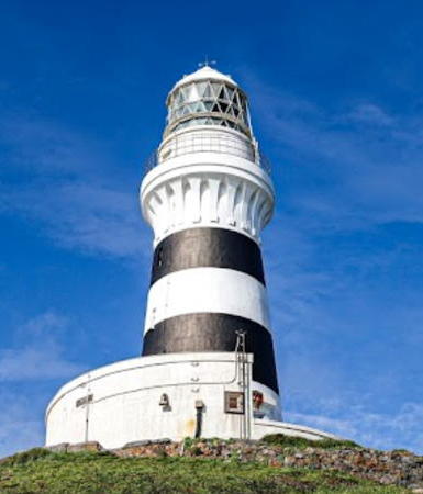
1870 (Richard Henry Brunton). Active; focal plane 51 m (267 ft); two white flashes every 16 s. 23 m (75 ft) round stone tower with lantern and gallery, rising from a circular 1-story stone keeper's house. 3rd order (?) Fresnel lens in use. Lighthouse painted with black and white horizontal bands. Chie Ikeda has the 2020 photo seen at right, Lighthouse-Japan.com has excellent photos, Wikimedia has a photo, a view from the sea is available, FOAL's page for the lighthouse also has distant views, Trabas has a distant view, and Google has a satellite view. Inaugurated on 11 November 1870, this is the oldest Western-style lighthouse surviving in its original form in Japan. It was declared a national historic site during celebrations in 1969 marking the 100th anniversary of its construction. Located on a small rocky islet about 12 km (7.5 mi) south southwest of Shimoda harbor and 9 km (5.5 mi) southwest of the Suzaki Ebisu Shima Light. Accessible only by boat. Site and tower closed. . ARLHS JPN-353; JCG-2447; Admiralty M6290; NGA 5548.
** Irō Saki (Iro Saki, Irozaki, Cape Iro) (2)
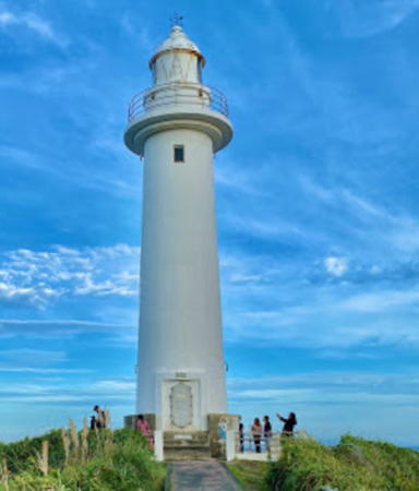
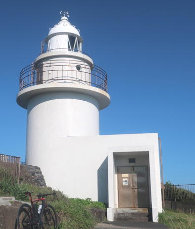
1933 (station established 1871). Active; focal plane 60 m (197 ft); flash every 8 s, alternately red and white. 11 m (36 ft) round cylindrical concrete tower with lantern and gallery, attached to a small equipment room. Entire lighthouse painted white. A Coast Guard photo is at the top of this page, Kazuya Minami's photo shows the steep site, a third photo shows the approach to the lighthouse, Trabas has a closeup, Lighthouse-Japan.com has excellent photos, FOAL's page for the lighthouse has good photos, Forand has a historic postcard view, Okada Yūji has a street view and Google has a satellite view. This historic light station marks the southernmost tip of the Izu peninsula, a very dangerous area for navigation. In good weather visitors can follow a walkway down to land's end. The original lighthouse was demolished after being heavily damaged by a typhoon in 1932. Located atop a precipitous slope at the tip of the Izu Peninsula, about 12 km (7.5 mi) southwest of Shimoda, commanding a spectacular view of the open Pacific. Accessible by road and a short walk. Site open, tower closed except for two open houses each year, one in July and the other on the first Saturday of November. . ARLHS JPN-176; JCG-2448; Admiralty M6270; NGA 5572.
* Irō Saki Directional
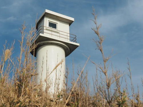
1972. Active; focal plane 64 m (210 ft); continuous light, white, red or green light depending on direction. 8 m (26 ft) round cylindrical concrete tower with lantern and a small gallery, mounted on a square concrete base. Lighthouse-Japan.com has an excellent closeup, Trabas also has a closeup, FOAL's page has additional photos, Okada Yūji has a street view and Google has a satellite view. Located on the heights about 70 m (75 yd) above the historic lighthouse, this light displays narrow sectors to the northeast to guide westbound ships around the tip of the peninsula. Site open, tower closed. JCG-2449; Admiralty M6270.4; NGA 5576.

Mikomoto Shima Light, Minamiizu, September 2020
Google Maps photo by Chie Ikeda
Mera Kō
Date unknown. Active; focal plane 17 m (56 ft); two red flashes every 6 s. 11 m (36 ft) round concrete tower with flared top, attached to a 1-story concrete equipment shelter. Entire lighthouse is red. FOAL has a photo, Trabas has a closeup photo, Ozawa Naoki has a photo, and Google has a satellite view. Located on a detached breakwater at the entrance to Mera harbor, in the lee of Irō Saki. Accessible only by boat. Site open, tower closed. ARLHS JPN-1434; JCG-2450.1; Admiralty M6269.6; NGA 5580.
* Hagachi (Hagati) Saki
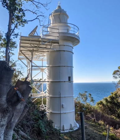
1977. Active; focal plane 116 m (381 ft); white flash every 5 s. 14 m (46 ft) round cylindrical steel tower with lantern and gallery, painted white. This important lighthouse marks the eastern entrance to Suruga Bay. A photo is at right, Lighthouse-Japan.com has closeup photos, Trabas has a view, Tomio Tatsumi has a 2005 photo showing the lighthouse being repainted, and Google has a satellite view. Accessible by twisting mountain roads; the author of Lighthouses of Japan confesses that he had some difficulty finding the road to the lighthouse, but he succeeded eventually. Parking is provided and a hiking trail leads to the lighthouse. Located on a promontory about 8 km (5 mi) south of Matsuzaki. Site open if you can find it, tower closed. . ARLHS JPN-076; JCG-2451; Admiralty M6269.5; NGA 5584.

Matsuzaki Town Lighthouse
Matsuzaki Kō
Date unknown. Active; focal plane 12 m (39 ft); red light, 2 s on, 2 s off. 8.5 m (28 ft) concrete post attached to a small 1-story equipment room. Entire lighthouse is red. Trabas has a closeup photo, FOAL's page for the lighthouse has several photos, and Google has a satellite view and a distant street view across the harbor. Located at the end of the south breakwater at Matsuzaki. Site status unknown; this breakwater is not walkable. JCG-2452; Admiralty M6269.3; NGA 5588.

Nishiizu (West Izu) Town Lighthouses
#Nishina (Nisina)
1970. Inactive since 2009 and later demolished. 9 m (30 ft) round hourglass-shaped concrete tower, painted white. Lighthouse-Japan.com has photos but Google's satellite view confirms that the lighthouse has been removed. Formerly located on a promontory on the north side of the entrance to the harbor of Matsuzaki and the south side of the entrance to the harbor of Nishina. Site open. ARLHS JPN-419; ex-JCG-2454; ex-Admiralty M6269.24; ex-NGA 5596.
Nishina Kō (2?)
Date unknown (around 2009?). Active; focal plane 12 m (39 ft); red flash every 3 s. 9.5 m (28 ft) concrete post attached to a small 1-story equipment room. Entire lighthouse is red. This is apparently a new light. Trabas has a closeup photo, FOAL has a 2010 view across the harbor, and Google has a satellite view and a distant street view. Located at the end of a detached breakwater at Nishina. Accessible only by boat. JCG-2453; Admiralty M6269.27; NGA 5592.

Hgachi Saki Light, Minamiizu
Instagram photo by if23bc
* Tago Kō
1938. Active; focal plane 10 m (33 ft); green flash every 3 s. 8.5 m (28 ft) concrete post attached to a small 1-story equipment room. Entire lighthouse is white. Trabas has a closeup photo, FOAL's page for the harbor lights has photos, Keiichi Nomura has a 2022 scenic view, and Google has a satellite view. Located at the end of the north breakwater at Tago. Accessible by walking the pier. Site open, tower closed. ARLHS JPN-1447; JCG-2455.3; Admiralty M6269.22; NGA 5602.
Tagoshima (Taka Shima, Tago Shima)
Date unknown. Active; focal plane 31 m (102 ft); white flash every 3 s. 9 m (30 ft) round concrete tower attached to a 1-story concrete equipment building. Entire lighthouse is white. Trabas has a photo, FOAL's page for the harbor lights has photos, and Google has a satellite view. Located atop an island at the end of a dangerous reef about 4 km (2.5 mi) northwest of Matsuzaki. Site status unknown. . ARLHS JPN-1446; JCG-2455; Admiralty M6269.2; NGA 5600.
* Arari Kō
Date unknown. Active; focal plane 13 m (43 ft); white light, 3 s on, 3 s off. 11 m (36 ft) round concrete tower mounted on a round 1-story equipment room. Entire lighthouse painted white. A photo is at right, Trabas has a closeup photo, Lighthouse-Japan.com has a page with good photos, an osprey flies by the lighthouse in the photo from Misty's Tour, FOAL has another photo, Yan Fumei has a photo, and Google has a satellite view and a distant street view. Located at the end of the short breakwater at Arari, a small port about 7 km (4.5 mi) north of Matsuzaki. Site open, tower closed. . ARLHS JPN-025; JCG-2456; Admiralty M6269; NGA 5604.
Arari Kō Light
Arari Kō Light, Nishiizu, August 2006
Flickr Creatve Commons photo by Nemo's great uncle

Information available on lost lighthouses:

Notable faux lighthouses:

Adjoining pages: Northeast: Tōkyō and Kanegawa | South : Nanpō Islands | West: Western Shizuoka

Return to the Lighthouse Directory index | Ratings key

Posted November 5, 2006. Checked and revised July 26, 2023. Lighthouses: 28. Site copyright 2023 Russ Rowlett and the University of North Carolina at Chapel Hill.