Lighthouses of Japan: Western Shizuoka

The nation of Japan, known in Japanese as Nihon or Nippon (日本), occupies an archipelago off the east coast of Asia. The four main islands are Hokkaidō in the north, Honshū (the largest) in the center, Shikoku in the south, and Kyūshū in the southwest. The country includes thousands of other islands of all sizes; among them the Ryūkyū (Nansei) Islands are a long chain extending to the southwest and including the large island of Okinawa, and the Nanpō Islands are another long chain extending south into the Pacific Ocean. Much of Japan is mountainous but the coastal regions are densely populated and urbanized; the country's population is about 126 million.

Japan is divided into 47 prefectures. This page lists lighthouses in the western half of Shizuoka Prefecture, which faces south on the Pacific Ocean southwest of Tokyo. Shizuoka includes some of Japan's best known and most scenic coastlines; the arrowhead-shaped Izu Peninsula shelters Suruga Bay with the famous cone of Mount Fuji on the northern horizon.

In Japanese the word for a lighthouse is tōdai or toudai (灯台). The words saki and misaki are for capes and headlands, hana ("nose") is a promontory, hantō is a peninsula, shima (also spelled sima or jima) is an island, bae is a reef, iwa or shi is a rocky reef, amase or se is a shoal, wan is a bay, nada is a sound or basin, kaikyō is a strait, kawa is a river, and or minato is a harbor.

Lighthouses in Japan are operated and maintained by the Japanese Coast Guard's Maritime Safety Agency. On Honshū there is usually one Coast Guard Section Office in each prefecture, sometimes two. Shizuoka has two Coast Guard offices: at Shimoda on the Izu Peninsula and at Shimizu on Suruga Bay. This page describes lighthouses of the Shimizu Coast Guard District, which includes Suruga Bay beginning with Izu City at the base of the Izu Peninsula.

ARLHS numbers are from the ARLHS World List of Lights. JCG numbers are the Japanese Coast Guard's light list numbers. Admiralty numbers are from volume M of the Admiralty List of Lights & Fog Signals. U.S. NGA List numbers are from Publication 112.

General Sources
Lighthouses in Japan - Shizuoka
A site providing photos and data for most major Japanese lighthouses.
Lighthouse-Japan.com - Shizuoka
Another comprehensive site with photos and notes from visits to many lighthouses.
Form of a Lighthouse - Shizuoka
Another site with many photos of Japanese lighthouses, cited below as FOAL.
Kiso's Lighthouses
This site also has excellent photos of Japanese lighthouses.
Misty's Japanese Lighthouse Tour -Shizuoka
Photos and a few notes for selected lighthouses.
Shimizu District Lighthouses
Photos and data from the Shimizu Coast Guard Office.
Online List of Lights - Japan
Photos posted by Alexander Trabas.
Lighthouses in Shizuoka Prefecture
Photos by various photographers available from Wikimedia.
Japan: Modern Lighthouses
Historic postcard images posted by Michel Forand.
Navionics Charts
Navigation chart for Shizuoka.

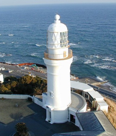
Omae Saki Light
Omae Saki Light, Omaezaki
Japanese Coast Guard Shimizu Office photo
Suruga Bay Lighthouses

Izu City Lighthouses
* Heda Kō
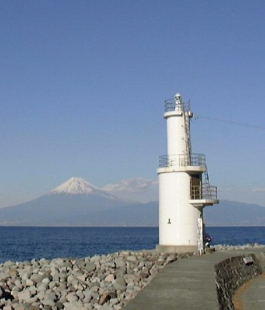
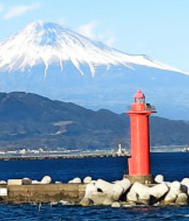
1952. Active; focal plane 17 m (56 ft); white light, 3 s on, 3 s off. 12 m (39 ft) two-stage round cylindrical concrete tower, painted white. A Coast Guard photo is at right, Trabas has a closeup photo, FOAL's page for the Heda lighthouses has photos, Lighthouse-Japan.com has photos, Yu Sasaki has a 2021 photo, Yamamoto Takao has a lovely 2022 photo, and Google has a closeup street view and a satellite view. Located at the entrance to the harbor of Heda, about 7 km (4.5 mi) north of Toi. Accessible by road, parking provided. Site open, tower closed. . ARLHS JPN-099; JCG-2458; Admiralty M6268.2; NGA 5616.
* Heda Kō Breakwater
1965. Active; focal plane 10 m (33 ft); green light, 3 s on, 3 s off. 8.5 m (8 ft) concrete post attached to a 1-story concrete equipment room. Entire lighthouse is white. FOAL's page for the Heda lighthouses has photos, Trabas has a closeup photo, and Google has a street view and a satellite view. Located on the Heda waterfront. Accessible by walking the pier. Site open, tower closed. JCG-2459; Admiralty M6268.4; NGA 5620.

Numazu City Lighthouses
Izu Ose Saki (Osezaki)
1957. Active; focal plane 16 m (52 ft); three white flashes every 13 s. 13 m (43 ft) round concrete tower mounted on a round 1-story concrete base. Entire lighthouse is white. Trabas has a closeup photo, FOAL's page for the lighthouse has photos, Wikimedia has a photo, a 2020 photo is available, the Coast Guard has photos (second lighthouse on the page), and Google has a satellite view and a closeup street view. Located on a cape at the northwestern corner of the Izu Peninsula. It is not clear if there is road access to this site, but the light should be accessible by a walk of 1 km (0.6 mi) or less. Site status unknown. . ARLHS JPN-200; JCG-2460; Admiralty M6267.7; NGA 5664.
Awa Shima (Izu Awashima)
1976. Active; focal plane 10 m (33 ft); two white flashes every 7 s. 8.5 m (28 ft) concrete post with gallery rising from a square 1-story concrete equipment shelter. Lighthouse colored with horizontal red and white bands. FOAL's page for the lighthouse has photos, Trabas has a photo, the Coast Guard has photos (third lighthouse on the page), and Google has a satellite view. Awashima is a small, scenic island in the northeastern corner of Suruga Bay. Located on the northern tip of Awashima, on the grounds of the Wyndham Garden Nagaizumi Hotel. Water taxi service to the islands should be available. Site open, tower closed. . JCG-2462; Admiralty M6267.6; NGA 5656.
Heda Kō Light
Heda Kō Light, Izu, with a view of Mount Fuji
Japanese Coast Guard Shimizu Office photo
Shizuura Kō
1971. Active; focal plane 10 m (33 ft); white flash every 3 s. 8.5 m (28 ft) hourglass-shaped concrete tower. Entire lighthouse is white. Trabas has a closeup photo, FOAL has another photo, and Google has a satellite view and a closeup street view. Located at the end of a breakwater at Shizuura, 2.5 km (1.5 mi) northeast of Awashima. Site and tower closed; the outermost section of the pier is gated. JCG-2464; Admiralty M6267.5; NGA 5648.

Fuji City Lighthouses
Tagonoura, the port district of Fuji City, is an industrial port with a very scenic location at the head of Suruga Bay and at the foot of Mount Fuji. The harbor is artificial, built by filling and dredging wetlands, with short breakwaters on either side of the entrance.

Tagonoura Kō East Breakwater
1962. Active; focal plane 16 m (52 ft); red light, 3 s on, 3 s off. 13 m (43 ft) round hourglass-shaped concrete tower. Entire lighthouse is red. Trabas has a good photo, FOAL has a photo (second row, left), a 2018 photo is available, and Google has a street view and a satellite view. Located at the end of the east breakwater. Site and tower closed. ARLHS JPN-1448; JCG-2467; Admiralty M6264; NGA 5624.
Tagonoura Range Front (2)
Date unknown. Active; focal plane 42 m (138 ft); continuous green light. 40 m (131 ft) square cylindrical skeletal tower painted white. Trabas has a photo, FOAL has a photo (last on the page), and Google has a street view and a satellite view. The original light was described as a 17 m (56 ft) round white concrete tower. The Tagonoura Range Lights are aimed lengthwise down the harbor. Located on the waterfront at the head of Tagonoura harbor. Site status unknown but the tower is easy to see from nearby streets. ARLHS JPN-1449; JCG-2469; Admiralty M6265; NGA 5632.
* Tagonoura Range Rear (2)
Date unknown. Active; focal plane 49 m (161 ft); continuous green light. 46 m (151 ft) square cylindrical skeletal tower painted white. Trabas has a photo, FOAL has a photo (last on the page), and Google has street view and a satellite view. The original light was described as a 23 m (75 ft) round white concrete tower. Located at a street intersection in the harbor district 215 m (700 ft) northwest of the front light. Site open, tower closed. ARLHS JPN-1450; JCG-2470; Admiralty M6265.1; NGA 5636.
Tagonoura Kō West Breakwater
Date unknown. Active; focal plane 16 m (52 ft); green light, 3 s on, 3 s off. 16 m (52 ft) round hourglass-shaped concrete tower with lantern and gallery. Entire lighthouse is white. K. Watanabe's photo is at right, FOAL has a photo (second row, right), Trabas has an evening photo, and Google has a beach view and a satellite view. The FOAL photo shows the lighthouse being repainted in 2012. Located at the end of the west breakwater. Site and tower closed. ARLHS JPN-1451; JCG-2468; Admiralty M6264.2; NGA 5628.

West Breakwater Light, Tagonoura, November 2017
Google Maps photo by k watanabe
 

Shizuoka City (Shimizu Port) Lighthouses
Shizuoka is a city of nearly 700,000 residents with a major port catering to container ships, dry bulk ships and cruise ships.
* Yui Kō (2)
1966. Active; focal plane 13 m (43 ft); continuous green light with a more intense flash every 6 s. 8.5 m (28 ft) concrete post attached to a 1-story concrete equipment shelter. Trabas has a closeup photo, FOAL's page for the lighthouse has a photo (bottom of the page), and Google has a street view and a satellite view. Google has a 2011 street view showing a previous lighthouse on what is now an inner breakwater. Located at the end of the outer breakwater of Yui harbor, a fishing harbor at the northwestern corner of Suruga Bay. Site status unknown. ARLHS JPN-1459; JCG-2471; Admiralty M6263; NGA 5668.
Shimizu Kō Outer Breakwater North
1999 (?) (relocated here in 2016). Active; focal plane 18 m (59 ft); green light, 4 s on, 4 s off. 12 m (39 ft) round concrete tower with a flared top. Entire lighthouse is white. Trabas has a photo, FOAL has photos (third row left and fifth row) and Google has a satellite view. This light has a complicated history. In 2007-08 the breakwater was extended northward about 600 m (0.4 mi), leaving this light in the middle. A new light was installed on a 10 m (33 ft) post at the end of the extension. Then in 2016 the post was removed and this light was relocated to the end of the extension. Google has a satellite view showing the former location of the light. Located at the north end of the detached main outer breakwater of Shimizu. Accessible only by boat. Site and tower closed. JCG-2476; Admiralty M6249.5 (it was M6249.6 when it was in the middle of the breakwater); NGA 5696.
Shimizu Kō Outer Breakwater South End
1999 (?). Active; focal plane 18 m (59 ft); three red flashes every 13 s. 16 m (52 ft) round cylindrical tower with lantern and gallery. Entire lighthouse is red. Feng Taijian's 2021 photo is at right, Trabas has a good photo, FOAL has a photo (top of the page, on the left), and Google has a satellite view and a distant street view across the harbor. Located at the south end of the detached main outer breakwater of Shimizu; the entrance to the harbor is between this light and the Miho Breakwater Light (see below). Accessible only by boat. Site and tower closed. ARLHS JPN-564; JCG-2477; Admiralty M6249.4; NGA 5692.
#Shimizu Ma Saki
1936. Inactive since 2017 and quickly removed. This was a 11 m (36 ft) concrete post attached to a 1-story square concrete equipment shelter. Entire structure was white. FOAL has a closeup (3/4 the way down the page) and Google has a 2015 street view of the lighthouse and a satellite view. of its former location. Formerly located on a sandy point inside the harbor entrance, about 800 m (1/2 mi) west of the Miho Breakwater Light (next entry). Site open, tower closed. ARLHS JPN-821; ex-JCG-2475; ex-Admiralty M6249; NGA 5700.

Shimizu Outer Breakwater South End Light, Shimizu, February 2021
Google Maps photo by Feng Taijian
Shimizu Miho Breakwater
Date unknown. Active; focal plane 18 m (59 ft); three green flashes every 13 s. 17 m (56 ft) round cylindrical tower with lantern and gallery, painted white. Lighthouse-Japan.com has good photos, Trabas has a closeup photo, FOAL has another photo (second row, right), Kazuya Yamazaki has a 2021 photo, and Google has a street view and a satellite view. Located at the outer end of a detached breakwater off the end of the Miho peninsula, which shelters the harbor of Shimizu. Accessible only by boat. Site and tower closed but there's a good view from the beach opposite the inner end of the breakwater. ARLHS JPN-563; JCG-2474; Admiralty M6248.4; NGA 5704.
* Miho Saki (Shimizu)
1912. Active; focal plane 21 m (69 ft); two white flashes every 20 s. 19 m (62 ft) octagonal concrete tower with lantern and gallery. The lighthouse appears to be unpainted white concrete; lantern painted white. A Coast Guard photo is at right, Trabas has a closesup photo, Lighthouse-Japan.com has photos, FOAL's page for the lighthouses has photos, a good photo and a 2020 photo are available, Forand has a historic postcard view, and Google has a closeup street view and a satellite view. This is said to be the oldest steel-reinforced concrete lighthouse in Japan. Located on the eastern point of the Miho peninsula in Shimizu. Site open, tower closed. . ARLHS JPN-822; JCG-2473; Admiralty M6248; NGA 5708.
Shimizu Kō Range Front
Date unknown. Active; focal plane 23 m (75 ft); continuous green light. 22 m (72 ft) triangular cylindrical skeletal tower. Entire lighthouse is white. Trabas has a good photo and Google has a street view and a satellite view. Located on the waterfront of Shimizu's south harbor. Site and tower closed but the tower can be seen from nearby. JCG-2481; Admiralty M6262; ex-NGA 5716.
* Shimizu Kō Range Rear
Date unknown. Active; focal plane 29 m (95 ft); continuous green light. 27 m (89 ft) triangular cylindrical skeletal tower. Entire lighthouse is white. Trabas has a photo and Google has a street view and a satellite view. Located beside a street in the harbor district 90 m (300 ft) south of the front light. Site open, tower closed. JCG-2482; Admiralty M6262.1; ex-NGA 5720.
Mochimune Breakwater
Date unknown. Active; focal plane 13 m (43 ft); green flash every 3 s. 10 m (33 ft) round white concrete tower with a flared top, attached to a small concrete equipment shelter. Trabas has a closeup photo and Google has a good satellite view and a very distant street view. Mochimune is a fishing port about 15 km (9 mi) southwest of central Shimuzu. Located at the east end of the detached breakwater of Mochimune. Accessible only by boat. Site status unknown. ARLHS JPN-1436; JCG-2483; Admiralty M6244; NGA 5724.
Miho Saki Light
Miho Saki Light, Shimizu
Japanese Coast Guard Shimizu Office photo
Yaizu City Lighthouses
Yaizu East Breakwater
Date unknown. Active; focal plane 18 m (59 ft); continuous green light with a more intense flash every 4 s. 14 m (46 ft) round cylindrical concrete tower. Entire lighthouse is white. Trabas has a closeup photo, another photo is available (near the bottom of the page), and Google has a satellite view. Located at the end of the east breakwater at Yaizu, a port about 20 km (13 mi) southwest of Shimizu. Site and tower closed. ARLHS JPN-1455; JCG-2485; Admiralty M6239.5; NGA 5740.
Kogawa North Breakwater
Date unknown. Active; focal plane 17 m (56 ft); green light, 2 s on, 2 s off. 13 m (43 ft) round cylindrical concrete tower. Entire lighthouse is white. Trabas has a closeup photo, Shun Yamada has a 2021 photo, and Google has a satellite view. Located at the end of the main breakwater guarding the southern entrance to the harbors of Kogawa and Yaizu. Site status unknown. ARLHS JPN-1431; JCG-2488; Admiralty M6239; NGA 5744.
* Ōigawa Kō (South Breakwater)
Date unknown. Active; focal plane 14 m (46 ft); green flash every 3 s. 8.5 m (28 ft) concrete post rising from a square 1-story concrete equipment shelter. Entire lighthouse is white. Trabas has a closeup photo, Shun Yamada has a 2021 photo, and Google has a satellite view. Located at the end of a short breakwater on the south side of the entrance to the Ōigawa harbor basin at the south end of Yaizu. Accessible by walking the pier. Site open, tower closed. ARLHS JPN-1438; JCG-2490; Admiralty M6236; NGA 5752.

Makinohara City Lighthouse
Sagara Kō (East Breakwater)
Date unknown. Active; focal plane 15 m (49 ft); continuous green light with two more intense flashes every 10 s. 10 m (33 ft) robust concrete post light attached to a square 1-story concrete equipment room. Entire lighthouse is white. A 2022 photo is at right, Trabas has a closeup photo, and Google has a street view and a satellite view. Located at the end of the main breakwater of Sagara, a fishing port at the southwestern corner of Suruga Bay. Site status unknown. ARLHS JPN-1440; JCG-2491; Admiralty M6235; NGA 5760.

Sagara Kō Light, Makinohara, February 2022
Google Maps photo by Ponsuke

Southwest Coast (Pacific Ocean) Lighthouses

Omaezaki City Lighthouses
Omaezaki Kō West Outer Breakwater
Date unknown. Active; focal plane 13 m (43 ft); two red flashes every 6 s. 10.5 m (34 ft) round concrete tower with a flared top, attached to a small equipment shelter. Entire lighthouse is red. Trabas has a closeup photo, FOAL has a photo (fifth row, right), and Google has a satellite view. Omaezaki Kō is a modern port just inside Cape Omae; Honda automobiles are shipped from the port. This light is located at the east end of a detached outer breakwater of the harbor. Accessible only by boat. Site open, tower closed. JCG-2491.8; Admiralty M6234.7; NGA 5768.
* Omaezaki Kō West Middle Breakwater
1978. Active; focal plane 13 m (43 ft); red flash every 4 s. 10 m (33 ft) concrete post attached to a square 1-story concrete equipment room. Entire lighthouse is red. Trabas has a closeup photo, FOAL has a photo (halfway down the page), and Google has a satellite view. This light is located on the west breakwater of the entrance to the inner portion of the harbor. Accessible by walking the pier. Site open, tower closed. JCG-2492; Admiralty M6234.5; NGA 5770.
Omaezaki Kō East Middle Breakwater (B Breakwater) (?)
Date unknown. Inactive since 2018 and likely to be removed. 10 m (33 ft) concrete post attached to a square 1-story concrete equipment room. Entire lighthouse is white. FOAL has a photo (next to last photo on the page), and Google has a satellite view. Located on a detached breakwater on the east side of the entrance to the inner portion of the harbor. Accessible only by boat. Site open, tower closed. ex-JCG-2493; ex-Admiralty M6234; NGA 5772.
Omaezaki Kō East Inner Breakwater (C Breakwater)
Date unknown. Active; focal plane 12 m (39 ft); green light, 2 s on, 2 s off. 10 m (33 ft) round conical concrete tower. Entire lighthouse is white. Trabas has a closeup photo, FOAL has a photo (third from last row on the page), and Google has a satellite view. Located on a breakwater on the west side of the south entrance to the harbor. Site status unknown (may be accessible by walking the pier). JCG-2494; Admiralty M6233; NGA 5774.
**** Omae Saki (Omaezaki) (2)
1874 (Richard Henry Brunton). Active; focal plane 54 m (177 ft); white flash every 10 s. 22 m (72 ft) round cylindrical brick tower with lantern and gallery. A semicircular visitor reception building is attached to the base of the tower. Entire lighthouse painted white. A Coast Guard photo appears at the top of this page, Trabas has an excellent photo, Lighthouse-Japan.com has excellent photos, FOAL's page for the lighthouse has good photos, Yu Sasaki has a 2021 photo, Forand has a historic postcard view, Shigeo Sawada has a closeup street view, and Google has a satellite view. This beautiful and historic lighthouse is one of the first Western-style lighthouses in Japan built by the British engineer Richard Henry Brunton; it replaced a much older Edo-era wood lighthouse. The lighthouse guards the western entrance to Suruga Bay and commands an impressive view of the Pacific to the south, Suruga Bay and Mount Fuji to the north. Located on the tip of the cape about 40 km (25 mi) east of Hamamatsu. Site open, tower open daily. . ARLHS JPN-487; JCG-2495; Admiralty M6228; NGA 5778.
Gozen Iwa
Date unknown. Active; focal plane 18 m (59 ft); two white flashes every 8 s. 11 m (36 ft) round concrete tower with lantern and gallery, mounted on a platform supported by three robust piles. Entire lighthouse is white. Trabas has a good photo, FOAL has photos (bottom of the page), the Coast Guard has a photo (first lighthouse on the page), and Bing has a distant satellite view. Located on an isolated rock about 3.5 km (2.2 mi) east of Omae Saki. Accessible only by boat. Site open, tower closed. . ARLHS JPN-1425; JCG-2496; Admiralty M6230; NGA 5780.

Hamamatsu City Lighthouses
* Kakezuka (Tenryu Kawa, "Mound Lighthouse")
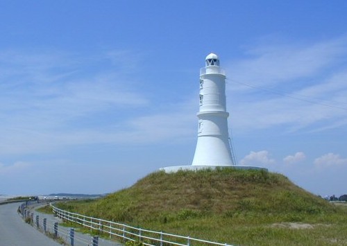
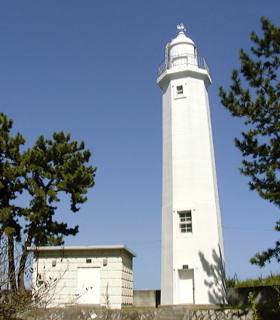
1880 (rebuilt and relocated in 2002). Active; focal plane 25 m (82 ft); white light, 3 s on, 3 s off. 16 m (52 ft) round cast iron tower with lantern and gallery, raised on a conical concrete base. Entire lighthouse painted white. The Coast Guard's photo is at right, Lighthouse-Japan.com has good photos, FOAL's page for the lighthouse has several photos, Trabas has a fine closeup photo, Masaru Araki has a 2021 photo, Misty's Tour has additional very good photos, and Google has a satellite view and a 2016 street view. In 2002 this historic iron lighthouse was relocated to escape beach erosion and placed on a new base atop a circular mound; ever since, it has been called the Mound Lighthouse. In 2019 a tall berm was built to slow continued erosion. Located on the east side of the entrance to the Tenryu River (kawa) in Iwada, south of Hamamatsu. Site open, tower closed. . ARLHS JPN-212; JCG-2499; Admiralty M6224; NGA 5792.
* Maisaka
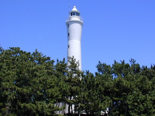
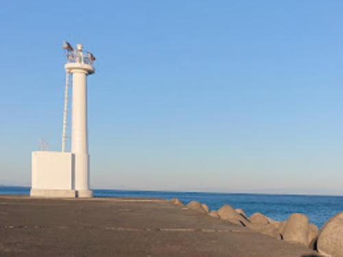
1964. Active; focal plane 137 m (121 ft); two white flashes every 20 s. 28 m (92 ft) round cylindrical concrete tower, flared near the top, with lantern and gallery; lantern with a sharp-pointed conical roof. Entire lighthouse painted white. A Coast Guard's photo is at right, Lighthouse-Japan.com has good photos, Trabas also has a good photo, Shigeo Sawada has a 2021 photo, FOAL's page for the lighthouse has several photos, and Google has a street view and a satellite view. Located on the east side of the entrance to Hamana Lake (actually a lagoon converted into a harbor), about 12 km (7.5 mi) southwest of Hamamatsu. Site open, tower closed. . ARLHS JPN-327; JCG-2501; Admiralty M6219; NGA 5800.
Hamana Kō
Date unknown. Active; focal plane 13 m (43 ft); two red flashes every 7 s. 10 m (33 ft) round hourglass-shaped red concrete tower. Trabas has a closeup photo, a 2020 drone view is available, FOAL has a photo (2/3 the way down the page), and Google has a satellite view. Located at the end of a short detached breakwater on the east side of the entrance to the Hamana lagoon. Accessible only by boat. Site status unknown. ARLHS JPN-1426; JCG-2502; Admiralty M6221.2; NGA 5808.


Kakezuka Light, Hamamatsu
Japanese Coast Guard Shimizu Office photo
Maisaka Light
Maisaka Light, Hamamatsu
Japanese Coast Guard Shimizu Office photo
Information available on lost lighthouses:

Notable faux lighthouses:

Adjoining pages: East: Eastern Shizuoka | West: Aichi

Return to the Lighthouse Directory index | Ratings key

Posted November 5, 2006. Checked and revised August 2, 2023. Lighthouses: 31. Site copyright 2023 Russ Rowlett and the University of North Carolina at Chapel Hill.