Lighthouses of Japan: Aichi Prefecture (Nagoya Area)

The nation of Japan, known in Japanese as Nihon or Nippon (日本), occupies an archipelago off the east coast of Asia. The four main islands are Hokkaidō in the north, Honshū (the largest) in the center, Shikoku in the south, and Kyūshū in the southwest. The country includes thousands of other islands of all sizes; among them the Ryūkyū (Nansei) Islands are a long chain extending to the southwest and including the large island of Okinawa, and the Nanpō Islands are another long chain extending south into the Pacific Ocean. Much of Japan is mountainous but the coastal regions are densely populated and urbanized; the country's population is about 126 million.

Japan is divided into 47 prefectures. This page lists lighthouses of the prefecture of Aichi including the city of Nagoya, the fourth largest city of Japan. Located on the south coast of Honshū, Aichi Prefecture surrounds the busy harbors of Atsumi and Chita Bays and the east side of Ise Bay.

In Japanese the word for a lighthouse is tōdai or toudai (灯台). The words saki and misaki are for capes and headlands, hana ("nose") is a promontory, hantō is a peninsula, shima (also spelled sima or jima) is an island, bae is a reef, iwa or shi is a rocky reef, amase or se is a shoal, wan is a bay, nada is a sound or basin, kaikyō is a strait, kawa is a river, and or minato is a harbor.

Lighthouses in Japan are operated and maintained by the Japanese Coast Guard's Maritime Safety Agency. On Honshū there is usually one Coast Guard Section Office in each prefecture, sometimes two. Aichi Prefecture has a single office at Nagoya.

ARLHS numbers are from the ARLHS World List of Lights. JCG numbers are the Japanese Coast Guard's light list numbers. Admiralty numbers are from volume M of the Admiralty List of Lights & Fog Signals. U.S. NGA List numbers are from Publication 112.

General Sources
Lighthouses in Japan - Aichi
A site providing photos and data for most major Japanese lighthouses.
Lighthouse-Japan.com - Aichi
Another comprehensive site with photos and notes from visits to many lighthouses.
Form of a Lighthouse - Aichi
Another site with many photos of Japanese lighthouses, cited below as FOAL.
Lighthouse Visits
This site has photos for many lighthouses in this area.
Misty's Japanese Lighthouse Tour - Aichi
Photos and a few notes for lighthouses in all parts of the country.
Online List of Lights - Japan
Photos posted by Alexander Trabas.
Nagoya - Navigation Signs
Posted by the Nagoya Coast Guard Office, links to pages on six major lighthouses.
Lighthouses in Aichi Prefecture
Photos by various photographers available from Wikimedia.
Japan: Modern Lighthouses
Historic postcard images posted by Michel Forand.
Navionics Charts
Navigation chart for Ise Bay.


Noma Saki Light, Chita, July 2021
Google Maps photo by Paul Yincher
Tahara City (Atsumi Peninsula) Lighthouses
The Atsumi Peninsula separates Mikawa Bay from the Pacific; the south coast of the peninsula is the only part of Aichi Prefecture that faces the open ocean. The city of Tahara occupies nearly all of the peninsula.

*
Akabane Kō
1991. Active; focal plane 13 m (43 ft); two red flashes every 6 s. 9.5 m (31 ft) round concrete tower with a flared top, attached to a small 1-story concrete equipment shelter. Entire lighthouse covered with red tiles. FOAL's page for the lighthouse has several photos, Mike Romani has a photo, Trabas has a closeup photo, a 2020 closeup is available, and Google has a satellite view and a distant street view. Located at the end of the east breakwater at Akabane, an artificial small boat harbor on the south side of the Atsumi Peninsula. Accessible by walking the pier. Site open, tower closed. JCG-2503.3; Admiralty M6218.5; NGA 5810.
** Irago (Irako) Misaki
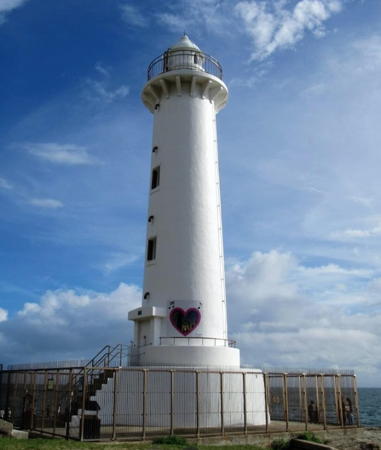
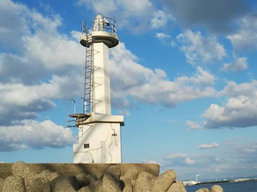
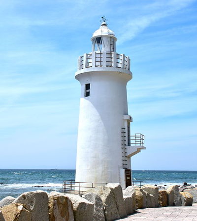
1929. Active; focal plane 16 m (52 ft); white light, 3 s on, 3 s off. 15 m (49 ft) round concrete tower with lantern and gallery. Entire lighthouse painted white. A photo is at right, a good 2021 photo is available, the Coast Guard has a page for the lighthouse, Lighthouse-Japan.com has several photos, Wikimedia has several photos, Trabas has a great photo, FOAL's page has several photos, Forand has a historic postcard view, and Google has a street view and a satellite view. The tower is probably endangered: the base of the lighthouse is almost in the surf. A tall navigation control tower for Ise Bay was built in 2003 on the heights above the lighthouse. This lighthouse is a very popular attraction; parking is available and a broad walkway leads down to the lighthouse (the walk is about 1 km (0.6 mi) roundtrip). Located at the tip of the Atsumi peninsula near the town of Atsumi, marking the east side of the entrance to Ise and Mikawa Bays. Accessible by road. Site open, tower closed. . ARLHS JPN-174; JCG-2507; Admiralty M6052; NGA 5812.
* Atsumi (Irago Misaki, Irako Kō) Breakwater
1960. Active; focal plane 12 m (39 ft); red light, 3 s on, 3 s off. 11 m (36 ft) concrete post attached to a square 1-story concrete equipment room. Entire lighthouse covered with small red tiles. Trabas has a closeup photo, a 2021 photo is available, FOAL's page has a photo (bottom of the page, on the left), and Google has a satellite view and a distant street view. Located at the end of the main breakwater at Atsumi, about 1.5 km (1 mi) northeast of Irago Misaki. Accessible by walking the breakwater; there's also a good view from the Ise-Wan Ferry crossing the mouth of Ise Bay to Toba in Mie Prefecture. Site open, tower closed. ARLHS JPN-1691; JCG-2520; Admiralty M6053; NGA 5816.
* Tatsuma (Tatuma) Saki
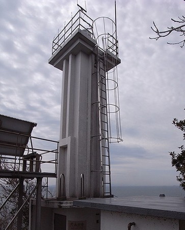
1959. Active; focal plane 14 m (46 ft); white light occulting three times every 13 s. 11 m (36 ft) square cylindrical concrete tower. The lighthouse is covered with small white ceramic tiles. The Coast Guard has a page for the lighthouse, a 2022 photo is available, Lighthouse-Japan.com has photos, Trabas has a closeup, FOAL's page for the lighthouse has several photos, Misty's Tour has additional photos, and Google has a satellite view and a street view from the beach walkway. Located on a cape at the southern entrance to Mikawa Bay, an eastern branch of Ise Bay, about 9 km (5.5 mi) northeast of Irago Misaki. Site open, tower closed. . ARLHS JPN-635; JCG-2533; Admiralty M6055.5; NGA 5836.

Irago Misaki Light, Tahara, May 2015
Wikimedia Creative Commons photo by Bariston
Hime Shima
Date unknown. Active; focal plane 14 m (46 ft); three red flashes every 12 s. 10 m (33 ft) round cylindrical concrete tower. Entire lighthouse is red. Trabas has a photo, FOAL's page has distant views (third and fourth rows on the page), and Google has a satellite view. Hime Shima is a small island off the eastern harbor of Tahara. Located at the end of a breakwater projecting from the east side of the island. Accessible only by boat. Site open, tower closed. JCG-2540.5; Admiralty M6209.5; NGA 5873.

Toyohashi City Lighthouses
Toyohashi is an industrial city of about 375,000 residents at the head of Mikawa Bay and the base of the Atsumi Peninsula.

Toyohashi Kō (Detached Breakwater Southwest End)
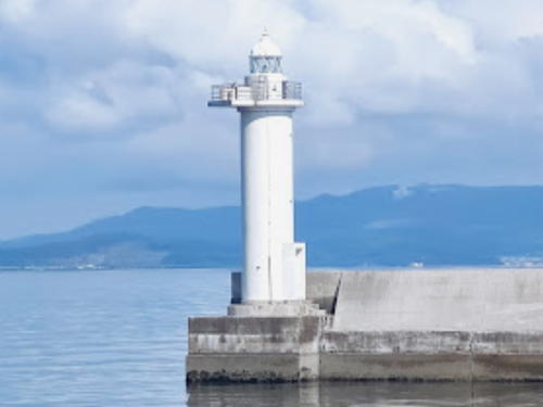
Date unknown. Active; focal plane 17 m (56 ft); green flash every 5 s. 16 m (52 ft) round cylindrical tower with lantern and gallery, painted white. Kenichiro Asai's photo is at right, Trabas has a photo, FOAL has a photo (second row, left), and Google has a satellite view. This lighthouse marks the principal entrance to the city's several harbors. Located at the southwest end of the detached main breakwater of Toyohashi. Accessible only by boat. Site and tower closed. ARLHS JPN-1718; JCG-2552.5; Admiralty M6208; NGA 5874.
* Maeshiba
1669. Inactive since 1908. Approx. 9 m (30 ft) square traditional-style wood tower. Midoka Imai has a 2016 closeup, another photo is available, and Google has a street view and a satellite view. This is one of the best-preserved traditional lighthouses in Japan. It was damaged by Typhoon Vera (known in Japan as the Ise Bay Typhoon) in September 1959 and it was restored in 1966. Located on the waterfront in Maeshiba (now a neighborhood in Toyahashi City), on the north side of the entrance to the Toyogawa River. Site open, tower status unknown.

Toyohashi Kō Light, Toyohashi, July 2021
Google Maps photo by Kenichiro Asai

Gamagōri City Lighthouses
Gamagōri is a light industrial city and fishing port of about 80,000 residents on the northeast side of Mikawa Bay.

Miya South Breakwater West Head
Date unknown. Active; focal plane 9 m (30 ft); red light, 3 s on, 3 s off. 8 m (26 ft) concrete post rising from a square 1-story concrete equipment shelter. Entire lighthouse is red. Trabas has a closeup photo, FOAL's page for the harbor has photos, and Google has a street view and a satellite view. Located at the west end of a detached breakwater off the Miya harbor in Gamagōri, on the north side of Mikawa Bay. Accessible only by boat. Site open, tower closed. ARLHS JPN-1701; JCG-2554; Admiralty M6204; NGA 5864.
Gamagōri Kō East Breakwater
Date unknown. Active; focal plane 12 m (39 ft); red light, 2 s on, 2 s off. 9 m (30 ft) concrete post attached to a square 1-story concrete equipment shelter. Entire lighthouse is red. Trabas has a closeup photo, Lighthouse Visits has a photo and Google has a satellite view. Located at the west end of a detached breakwater off Gamagōri's main harbor. Accessible only by boat. Site open, tower closed. ARLHS JPN-1685; JCG-2562; Admiralty M6202; NGA 5868.
Katahara (Katanohara) Kō
Date unknown. Active; focal plane 12 m (39 ft); red flash every 3 s. 6.5 m (22 ft) round concrete tower with a flared top, attached to a small 1-story concrete equipment shelter. Entire lighthouse covered with red tiles. Trabas has a closeup photo, Lighthouse Visits has a photo (first lighthouse on the page), and Google has a distant street view and a satellite view. Katahara and Nishiura are adjoining districts of Gamagōri, and the two harbor basins have a common entrance. Located at the end of the east breakwater at Katahara/Nishiura. Site status unknown. ARLHS JPN-1695; JCG-2564; Admiralty M6200; NGA 5880.
* Nishiura Kō (Mikawa Nisiura)
1962. Active; focal plane 12 m (39 ft); green flash every 3 s. 8.5 m (28 ft) concrete post attached to a 1-story concrete equipment room. Entire lighthouse is white. Trabas has a closeup photo, Lighthouse Visits has a photo (second lighthouse on the page), and Google has a distant street view and a satellite view. Located at the end of the south breakwater in Katahara/Nishiura, about 4 km (2.5 mi) northeast of Hashida Hana. Accessible by walking the pier. Site open, tower closed. JCG-2565; Admiralty M6199; NGA 5884.
* Hashida (Hasida) Hana
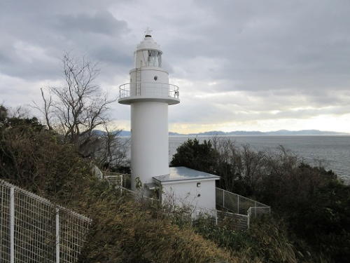
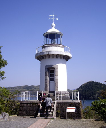
1971. Active; focal plane 36 m (118 ft); flash every 10 s, alternately red and white. 14 m (46 ft) round cylindrical concrete tower with lantern and gallery. Entire lighthouse painted white. The Coast Guard has a page for the lighthouse including the photo is at right, a 2021 photo is available, Lighthouse-Japan.com has good photos, Trabas has a closeup photo, FOAL's page for the lighthouse has two photos, Misty's Tour has photos, and Google has a satellite view. The lighthouse is adjacent to the Hotel Tatsuki. Located on a promontory extending into Mikawa Bay, about 7 km (4.5 mi) south of Gamagōri. Site open, tower closed. . ARLHS JPN-087; JCG-2566; Admiralty M6198; NGA 5888.

Hashida Hana Light, Gamagōri
Japanese Coast Guard Nagoya Office photo
Kuramai Kō
Date unknown. Active; focal plane 12 m (39 ft); green flash every 3 s. 9 m (30 ft) round hourglass-shaped concrete tower, attached to a small equipment shelter. Entire lighthouse is white. Trabas has a closeup photo, a 2022 photo is available, FOAL's page for the harbor has photos (third and sixth rows), and Google has a distant street view and a satellite view. Located on a detached breakwater protecting the Kuramai harbor, in the lee of Hashida Hana. Accessible only by boat. Site open, tower closed. JCG-2567; Admiralty M6197.6; NGA 5896.

Nishio City Lighthouses
Like its neighbor Gamagōri, Nishio is a light industrial city and fishing port on the north side of Mikawa Bay. Its population is about 170,000.
Kenashi (Kenasi) Shima
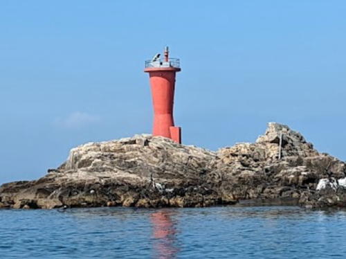
Date unknown. Active; focal plane 13 m (43 ft); red flash every 3 s. 10 m (33 ft) round hourglass-shaped concrete tower attached to a small equipment shelter. Entire lighthouse is red. A photo is at right, Trabas has a photo, FOAL's page for the harbor has photos (fourth and fifth rows on the page), a 2020 photo is available, and Google has a satellite view. Located on a rock off the west end of the island of Okinoshima, about 3 km (1.8 mi) west of Hashida Hana. Accessible only by boat. Site open, tower closed. JCG-2576; Admiralty M6195.6; NGA 5920.
* Nakashiba (Higashi-Hazu Kō East Breakwater)
1965. Active; focal plane 13 m (43 ft); continuous red light with two more intense flashes every 10 s. 8.5 m (28 ft) concrete post attached to a 1-story concrete equipment room. Entire lighthouse is red. Trabas has a closeup photo, FOAL's page for the harbor has photos (closeup at the bottom of the page), Lighthouse Visits has a photo (second lighthouse on the page), and Google has a satellite view and a distant street view. Located at the end of the east breakwater in Higashi-Hazu, about 4 km (2.5 mi) northwest of Hashida Hana. Accessible by walking the pier. Site open, tower closed. JCG-2573; Admiralty M6196.4; NGA 5916.
Higashi-Hazu Kō Detached Breakwater West End
Date unknown. Active; focal plane 12 m (39 ft); three red flashes every 12 s. 9 m (30 ft) round concrete tower with a flared top, attached to a small equipment shelter. Entire lighthouse is red. Trabas has a closeup photo, FOAL's page for the harbor has photos, Lighthouse Visits has a photo (third lighthouse on the page), and Google has a satellite view and a distant street view. Located at the west end of a detached breakwater protecting Higashi-Hazu harbor. Accessible only by boat. Site open, tower closed. JCG-2574; Admiralty M6196.5; NGA 5924.

Kenashi Shima Light, Nishio, April 2022
Google Maps photo by yuki k
Nishi Hazu Breakwater
Date unknown. Active; focal plane 12 m (39 ft); continuous red light with a more intense flash every 6 s. 8.5 m (28 ft) concrete post attached to a square 1-story concrete equipment shelter. Entire lighthouse is red. Trabas has a photo, Lighthouse Visits has a photo, and Google has a satellite view and a distant street view. Located on the south breakwater protecting Nishi-Hazu harbor. Accessible only by boat. Site open, tower closed. ARLHS JPN-1708; JCG-2578; Admiralty M6195; NGA 5936.
Akunami
Date unknown. Active; focal plane 10 m (33 ft); two white flashes every 5 s. 9 m (30 ft) round cylindrical concrete tower with gallery. Lighthouse painted black with one red horizontal band. Trabas has a photo, FOAL has photos (last two rows on the page), and Google has a satellite view and a very distant street view. Located on a rock off the Tobacho ward. Accessible only by boat. Site open, tower closed. JCG-2580; Admiralty M6194.5; NGA 5952.
Naka Shima (Nakajima)
Date unknown. Active; focal plane 10 m (33 ft); one long and two short red flashes every 8 s. 9 m (30 ft) round cylindrical concrete tower with gallery. Entire lighthouse is red. Trabas has a closeup photo, FOAL has photos (fourth and fifth rows on the page), and Google has a satellite view. Located on a rock off Kiracho Miyazaki. Accessible only by boat. Site open, tower closed. JCG-2582; Admiralty M6194.4; NGA 5948.
Sakushima Kō East
Date unknown. Active; focal plane 10 m (33 ft); six quick white flashes followed by one long white flash every 15 s. 8 m (26 ft) cocrete post attached to a square 1-story equipment shelter and mounted on a round concrete pier. Upper half of post painted yellow, lower half black. FOAL's page for Sakushima has photos (near the bottom of the page), Trabas has a very distant view, and Google has a satellite view. Sakushima is an island in Chita Bay about 4 km (2.5 mi) east of Minamichita at the tip of the Chita Peninsula and a simlar distance south of Isshiki on the mainland. Located on a reef off the southeastern tip of Sakushima. Accessible only by boat. Site open, tower closed. JCG-2605; Admiralty M6161.8; NGA 6040.
Sakushima Kō West Breakwater
1965. Active; focal plane 9.5 m (31 ft); green light, 6 s on, 2 s off. 8.5 m (28 ft) concrete post centered on a square 1-story concrete equipment shelter. Entire lighthouse is white. FOAL's page for Sakushima has photos, K. Shimizu has a photo, Shigeo Sawada has a closeup street view, and Google has a street view and a satellite view. Located on the west breakwater of Sakushima harbor. Accessible by walking the pier. Site open, tower closed. JCG-2606; Admiralty M6161.7; NGA 6048.
* Namiga Saki (Nangasaki, Sakushima)
1947. Active; focal plane 11 m (36 ft); white light, 3 s on, 3 s off. 10 m (33 ft) concrete post rising from a 2-story square concrete base. Entire lighthouse is white. A Google Maps street view is at right, the Coast Guard has a page for the lighthouse, FOAL's page for Sakushima has photos, Trabas has a very distant view, and Google has a satellite view. Located at the western tip of Sakushima. Site open, tower closed. . ARLHS JPN-1707; JCG-2608; Admiralty M6161.5; NGA 6008.

Namiga Saki Light, Sakushima, January 2015
Google Maps street view
 
* Eisei (Sako, Isshiki)
1951. Active; focal plane 15 m (49 ft); red light, 3 s on, 3 s off. 13 m (43 ft) concrete post rising from a 1-story equipment shelter. Entire lighthouse is red. Trabas has a photo, Lighthouse Visits has a photo, FOAL's page also has photos, and Google has a street view and a satellite view. Located on a dike beside a channel used by fishermen on the northwest side of Nishio. Site open, tower closed. ARLHS JPN-1709; JCG-2592; Admiralty M6178; NGA 5968.

Hekinan City Lighthouse
Hekinan is a city of about 75,000 residents, known for a large Toyota plant and for the manufacture of ceramic roofing tiles.

Kinuura Kō East Breakwater
Date unknown. Active; focal plane 20 m (66 ft); two red flashes every 6 s. 20 m (66 ft) round cylindrical tower with lantern and gallery, painted red. A photo is at right, Trabas has a distant photo, FOAL's Taketoyo page has photos (near the bottom of the page), Ryohsuke Torii has a drone view, and Google has a satellite view. The upper end of Chita Bay ends in an estuary that has been developed intensively as the port of Kinuura. This lighthouse and the one listed below under Taketoyo Town mark the ends of the two breakwaters at the lower end of the estuary. Located at the end of the east breakwater of Kinuura Kō. Site and tower closed. ARLHS JPN-1697; JCG-2594; Admiralty M6163.4; NGA 5972.

Handa City Lighthouses
Handa, on the upper west side of Chita Bay, is a city of about 120,000 residents known for breweries producing sake, soy sauce, and vinegar.

*
Kinuura Kō Middle Wharf
1969. Active; focal plane 9.5 m (31 ft); green flash every 4 s. 8.5 m (28 ft) concrete post centered on a square 1-story concrete equipment shelter. Entire lighthouse is white. Trabas has a closeup photo, FOAL's page has photos, Hironobu Saheki has a 2021 photo, and Google has a street view and a satellite view. This light is near the pedestrian entrance to the Kinuura Tunnel, which connects the two sides of the harbor. Located at the end of a broad wharf district, marking the entrance to the upper harbor of Kinuura. Site open, tower closed. ARLHS JPN-1698; JCG-2601; Admiralty M6164; NGA 5980.
 

Kinuura East Breakwater Light, Hekinan, February 2020
Google Maps photo by Kazu Sun
* Handa Kō Breakwater (?)
1975. Inactive since 2023; this light may be removed. 9.5 m (31 ft) concrete post rising from a 1-story concrete equipment shelter. Entire lighthouse is red. Trabas has a closeup photo, FOAL's page has photos, Hironobu Saheki has a 2021 photo, and Google has a street view and a satellite view. Located on a short breakwater at the base of the Kinuura Middle Wharf, sheltering a small harbor basin in downtown Handa. Accessible by walking the pier. Site open, tower closed. ARLHS JPN-1687; JCG-2602; Admiralty M6164.4; NGA 5992.

Taketoyo Town Lighthouses
* Taketoyo
1941. Active; focal plane 12 m (39 ft); green light, 3 s on, 3 s off. 10 m (33 ft) concrete post rising from a hexagonal 1-story concrete equipment room. Entire lighthouse is white. FOAL's Taketoyo page has photos, A 2018 photo is at right, Trabas has a closeup photo, and Google has a satellite view. Located at the end of the south breakwater pier at the older harbor of Taketoyo, on the west side of Kinuura Kō. Site open, tower closed. ARLHS JPN-1714; JCG-2596; Admiralty M6163; NGA 5984.
Kinuura Kō West Breakwater
Date unknown. Active; focal plane 20 m (66 ft); two green flashes every 6 s. 20 m (66 ft) round cylindrical tower with lantern and gallery, painted white. Trabas has a photo, FOAL's Taketoyo page has photos (near the bottom of the page), a sunset drone view is available, and Google has a satellite view. The upper end of Chita Bay ends in an estuary which has been developed intensively as the port of Kinuura. This lighthouse and one listed above under Hekinan mark the ends of the two breakwaters at the lower end of the estuary. Located in Taketoyo at the end of the west breakwater of Kinuura Kō. Site and tower closed. ARLHS JPN-1715; JCG-2595; Admiralty M6163.6; NGA 5988.

Taketoyo Light, Taketoyo, November 2018
Google Maps photo by Den-O 2

Mihama Town East Coast Lighthouse
Mihama occupies the center of the Chita Peninsula with waterfronts facing Chita Bay on the east and Ise Bay on the west.

Kōwa Kō South Breakwater
1962. Active; focal plane 10 m (33 ft); continuous red light with a more intense flash every 5 s. 8.5 m (28 ft) concrete post attached to a 1-story concrete equipment room. Entire lighthouse is red. Trabas has a closeup photo, FOAL's page for the harbor lights has several photos, Lighthouse Visits has a photo, and Google has a street view and a satellite view. Kōwa Kō is on the east side of the Chita Peninsula about 8 km (5 mi) south of Taketoyo. Located at the end of a breakwater on the south side of the river entrance, but the north side of the modern harbor. Site and tower closed (despite the photos, the pier appears dangerously narrow for walking). ARLHS JPN-1699; JCG-2604; Admiralty M6162; NGA 6000.

Minamichita Town Lighthouses
Minamichita (South Chita) occupies the end of the Chita Peninsula.
* Oi Kō No. 3 Breakwater
Date unknown. Active; focal plane 13 m (43 ft); green flash every 3 s. 8.5 m (28 ft) round cylindrical metal tower, painted white. Trabas has a closeup photo, FOAL's page for the harbor lights has a photo (bottom of the page, right), and Google has a satellite view and a street view across the harbor. NGA is incorrect in listing this as the No. 2 Breakwater. Located at the end of a breakwater at Oi harbor, about 3 km (2 mi) north of Morozaki. Accessible by walking the pier. Site open, tower closed. ARLHS JPN-1755; JCG-2613; Admiralty M6161.4; NGA 6084.
Owari Ō Iso
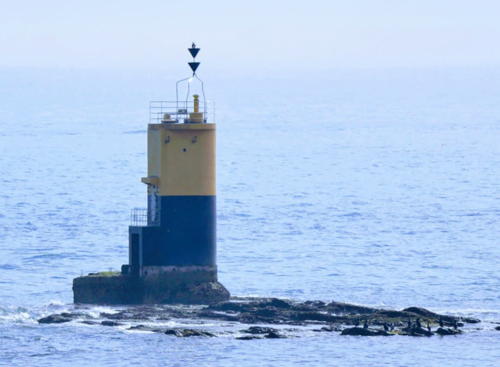
Date unknown. Active; focal plane 10 m (33 ft); quick-flashing white light. 9 m (30 ft) round cylindrical concrete tower with gallery. Upper half of the lighthouse painted black, lower half yellow. FOAL has a photo (eighth row on the page, right), Trabas has a very distant view, and Google has a satellite view. Located on a reef in the passage between Saku Shima and Himaka Shima at the entrance to Atsumi Bay. Site open, tower closed. JCG-2609; Admiralty M6160.6; NGA 6056.
Kadoishi
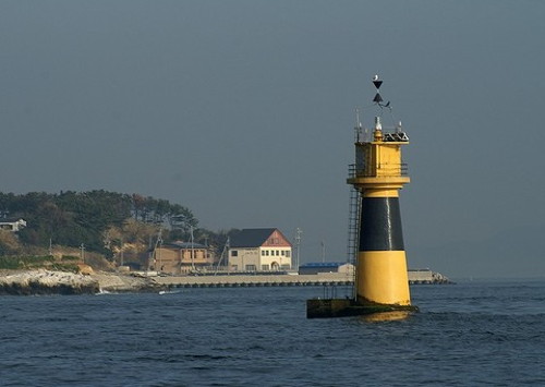
Date unknown. Active; focal plane 13 m (43 ft); nine quick white flashes every 15 s. 12 m (39 ft) round solid concrete tower with double gallery and the light mounted atop a square steel equipment room. Lighthouse painted yellow with one black horizontal band. A photo is at right, Trabas has a photo, Lighthouse Visits has a photo, FOAL has a photo (sixth row on the page, left), and Google has a satellite view. This beacon was refurbished in 2006; the equipment room was replaced. Located on a rock between Moro Saki (Morozaki), the southeast end of the Chita Peninsula, and Himaka Shima. Accessible only by boat. Site open, tower closed. JCG-2617; Admiralty M6160; NGA 6012.
Kadoishi Light
Kadoishi Light, Chita, November 2011
unattributed 30maps.com photo
Shimose Sho
Date unknown. Active; focal plane 10 m (33 ft); one short and one long red flash every 8 s. 10 m (33 ft) round concrete tower with double gallery. Entire lighthouse is red. Trabas has a photo, FOAL's page for the Morozaki lighthouses has photos (at the bottom of the page), and Google has a satellite view. Located on a reef about 800 m (1/2 mi) off the harbor of Himaka Shima. Site open, tower closed. JCG-2618; Admiralty M6160.2; NGA 6020.
Morozaki East Breakwater
Date unknown. Active; focal plane 12 m (39 ft); two green flashes every 6 s. 10 m (33 ft) round concrete tower, flared at the top and attached to a small 1-story equipment shelter. Entire lighthouse is white. Trabas has a closeup photo, Lighthouse Visits has a photo (third lighthouse on the page), and Google has a satellite view and a distant street view. Located at the east end of the detached main breakwater of Morozaki harbor. Accessible only by boat. Site open, tower closed. JCG-2619.5; Admiralty M6159.2; NGA 6032.
Okino Shima
Date unknown. Active; focal plane 9 m (30 ft); one short and one long green flash every 8 s. 9 m (30 ft) round concrete tower, flared at the top. Entire lighthouse is green. Trabas has a photo, Lighthouse Visits has a photo, FOAL's page for the Morozaki lighthouses has photos (eighth row on the page, left), and Google has a satellite view. NGA misspells the name as Okiro Shima. Located about 200 m (660 ft) southwest of the Morozaki East Breakwater Light. Accessible only by boat. Site open, tower closed. JCG-2619; Admiralty M6159.5; NGA 6024.
Ha Shima (Kashima, Morozaki)
Date unknown. Active; focal plane 11 m (36 ft); six quick white flashes followed by one long white flash every 15 s. 10 m (33 ft) square cylindrical concrete tower; upper half painted yellow, lower half black. Hironobu Saheki's 2021 photo is at right, Trabas has a closeup photo, Lighthouse Visits has a photo, FOAL's page for the Morozaki lighthouses has photos (bottom of the page), and Google has a satellite view. Located on a skerry off Morozaki, the tip of the Chita Peninsula. Accessible only by boat. Site open, tower closed. JCG-2622; Admiralty M6159; NGA 6036.
Shinoshima (Shinojima, Sinosima) Kō (North Breakwater)
Date unknown. Active; focal plane 12 m (39 ft); red flash every 3 s. 9 m (30 ft) round concrete tower with a flared top, attached to a small equipment shelter. Entire lighthouse is red. Trabas has a photo, Lighthouse Visits has photos, and Google has a satellite view. Shinoshima is an inhabited island about 4 km (2.5 mi) southeast of Morozaki; the population is about 1600. The island is accessible by ferries from Minamichita or from Irago on the other side of Mikawa Bay. Located at the north end of a detached breakwater at the northwest corner of the island. Accessible only by boat. Site open, tower closed. ARLHS JPN-1710; JCG-2622.5; Admiralty M6057.5; NGA 6060.
Shinoshima (Shinojima, Sinosima) Kō South Breakwater
Date unknown. Active; focal plane 11 m (36 ft); green flash every 3 s. 9 m (30 ft) concrete post, attached to a 1-story concrete equipment shelter. Entire lighthouse is white. Trabas has a photo, Lighthouse Visits has photos (second lighthouse on the page), and Google has a satellite view. Located on a short breakwater to the south side of the small island of Kojima, which partly shelters the harbor. Accessible only by boat. Site open, tower closed. ARLHS JPN-1711; JCG-2625.1; Admiralty M6056.2; NGA 6064.

Ha Shima Light, Minamichita, February 2021
Google Maps photo by Hironobu Saheki
Owari No Shima (Owari Nojima)
Date unknown. Active; focal plane 60 m (197 ft); two white flashes every 7 s. 10 m (33 ft) square cylindrical concrete tower with gallery, rising from a 1-story equipment building. A photo is at right, Trabas has a very distant view, and Google has a satellite view. Owari No Shima is a small island in the center of the entrance to Mikawa Bay (and Chita Bay) from Ise Bay. Located at the south end of the island; Accessible only by boat. Site status unknown. ARLHS JPN-498; JCG-2531; Admiralty M6055; NGA 6072.
Toyohama Kō South Breakwater
Date unknown. Active; focal plane 10 m (33 ft); two red flashes every 6 s. 7.5 m (25 ft) square concrete tower attached to a small 1-story concrete equipment room. Entire lighthouse is red. FOAL's page for the harbor lights has several photos, Lighthouse Visits has a photo, Trabas has a closeup photo, a photo showing both breakwater lights is available, and Google has a satellite view and a distant sea view. Located at the end of a detached outer breakwater at Toyohama, a small fishing port on Ise Bay 4 km (2.5 mi) west of Morosaki. Accessible only by boat. Site open, tower closed. JCG-2626; Admiralty M6158.5; NGA 6092.
* Toyohama Kō West Breakwater
1941. Active; focal plane 10 m (33 ft); green light, 3 s on, 3 s off. 8.5 m (28 ft) round concrete tower with a small gallery. Entire lighthouse is white. FOAL's page for the harbor lights has several photos, Lighthouse Visits has photos (second lighthouse on the page), Trabas has a closeup photo, a photo showing both breakwater lights is available, and Google has a satellite view and a distant street view. Located at the end of the main breakwater of Toyohama. Accessible by walking the pier. Site open, tower closed. JCG-2627; Admiralty M6158.2; NGA 6088.
Nakashu Kō East Breakwater
Date unknown. Active; focal plane 14 m (46 ft); red flash every 5 s. 8.5 m (28 ft) concrete post attached to a 1-story concrete equipment room. Entire lighthouse is red. FOAL's page for the harbor lights has several photos, Trabas has a photo, Lighthouse Visits has photos, and Google has a satellite view and a street view across the harbor. Located at the end of a detached outer breakwater at Nakashu, a small fishing port on Ise Bay 1.5 km (1 mi) west of Toyohama. Accessible only by boat. Site open, tower closed. ARLHS JPN-1705; JCG-2629; Admiralty M6156.5; NGA 6100.
No Shima Light
Owari No Shima Light, Chita, May 2011
unattributed 30maps.com photo

Mihama Town West Coast Lighthouse
* Noma Saki
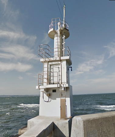
1921. Active; focal plane 20 m (66 ft); white light, 3 s on, 3 s off. 18 m (59 ft) round concrete tower with lantern and gallery. Entire lighthouse is white. Paul Tincher's photo is at the top of this page, the Coast Guard has a page for the lighthouse with a sunset photo, Trabas has a closeup photo, Lighthouse-Japan.com has good photos, FOAL's page for the lighthouse has excellent photos, Misty's Tour has photos, Hama Tako has a dramatic sunset photo, Forand has a historic postcard view, and Google has a street view and a satellite view. This lighthouse stands on a headland on the east side of Ise Bay, guiding ships northward from the bay's entrance. It is easily the best known and most visited lighthouse of Aichi Prefecture. Parking is available, although it is necessary to cross the busy coastal highway (route 247) to reach the lighthouse. Located about 15 km (9 mi) south of Tokoname. . ARLHS JPN-428; JCG-2632; Admiralty M6144; NGA 6108.

Tokoname City Lighthouses
Tokoname, on the east side of Ise Bay, is the location of Chūbu Centrair International Airport, Nagoya's international airport. The airport is built on a large artificial island in the bay.

*
Tokoname Inner Breakwater
1940. Active; focal plane 7.5 m (25 ft); red light, 2 s on, 2 s off. 6.5 m (21 ft) concrete post attached to a 1-story concrete equipment room. Entire lighthouse is red. Trabas has a closeup photo, FOAL's page has photos, Lighthouse Visits has a photo, and Google has a satellite view. Located at the end of the original Tokoname breakwater. Site open, tower closed. JCG-2640; Admiralty M6138; NGA 6120.
* #Tokoname Kō (1)
Date unknown. Replaced about 2014. This was an 8 m (26 ft) concrete post attached to a 1-story concrete equipment room. Entire lighthouse was red. No photo available. FOAL's 2015 photos (bottom of the page), Lighthouse Visits' September 2014 photo, and Google's satellite view show that the lighthouse has been replaced by a simple post (focal plane 12 m (39 ft); two red flashes every 6 s). Located at the end of the main Tokoname breakwater. Site open, tower closed. Active light: JCG-2639; Admiralty M6138.5; NGA 6116.
* Onisaki (Onizaki, Oniga Saki) North Breakwater
1956. Active; focal plane 12 m (39 ft); green light, 4 s on, 4 s off. 8.5 m (28 ft) concrete post attached to a 1-story concrete equipment room. Entire lighthouse is white. Trabas has a closeup photo, FOAL's page has photos, Lighthouse Visit has a photo, and Google has a satellite view and a street view across the harbor. Located at the end of the north breakwater of the fishing port at Onisaki. Accessible by walking the pier. Site open, tower closed. JCG-2641; Admiralty M6137; NGA 6124.

Chita City Lighthouse
Ise Wan Signal Station
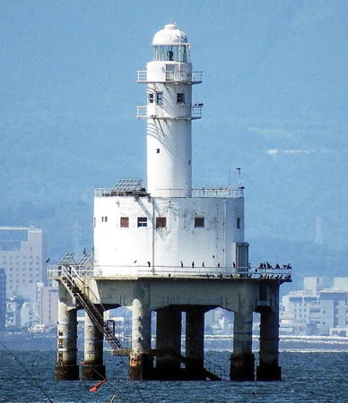
1961. Active; focal plane 25 m (82 ft); white flash every 10 s. 20 m (66 ft) round cylindrical tower with lantern and double gallery, centered on a round 1-story harbor control station. A photo is at right, the Coast Guard has a page for the station, Trabas has a photo, Lighthouse Visits has photos, FOAL has photos (bottom of the page), a 2020 photo is available, and Google has a satellite view. The original 4th order Fresnel lens from this lighthouse is displayed at the lighthouse museum adjoining the Nyudo Saki lighthouse in Oga, Akita Prefecture, northwestern Honshū. Located in Ise Bay (wan) about 6 km (3.5 mi) northwest of Tokoname. Accessible only by boat. Site and tower closed. . ARLHS JPN-1816; JCG-2645; Admiralty M6133; NGA 6136.

Ise Wan Signal Station Light, Chita
Instagram photo by chiisaiakari

Nagoya City Lighthouses
#Nagoya Middle Tidal Breakwater East End
Date unknown. Inactive since 2012 and demolished soon after. This was a 20 m (66 ft) round cylindrical tower with lantern and gallery, painted white. No photo available; Google's satellite view confirms that the lighthouse has been removed. The inner harbor of Nagoya is protected by a storm tide breakwater with two openings on either side of a large artificial island. This lighthouse stood at the west side of the eastern entrance, east of the artificial island. Site and tower closed. ARLHS JPN-1703; ex-JCG-2646; ex-Admiralty M6113; ex-NGA 6144.
Nagoya Middle Tidal Breakwater West End
Date unknown. Active; focal plane 15 m (49 ft); continuous red light with two more intense flashes every 8 s. 14 m (46 ft) round cylindrical tower, painted red. Trabas has a closeup photo and Google has a satellite view. This lighthouse marks the entrance to the western side of the inner harbor of Nagoya, west of the artificial island. Site and tower closed. ARLHS JPN-1704; JCG-2647; Admiralty M6115; NGA 6146.
* Shichiri Ferry (Atsuta-ku) (replica)
1955 replica of 1625 lighthouse. Inactive (a decorative light may be displayed). Approx. 14 m (46 ft) square wood traditional-style tower. A 2022 photo and another good photo is available, a night time photo shows the tower floodlit and displaying the decorative light, and Google has a street view and a satellite view. The original lighthouse guided boats carrying messages in a postal network connecting the major cities of 17th century Japan. Located on the waterfront in the Atsuta Ward of Nagoya. Site open, tower status unknown.
* Nagoya Pier 10 (Coal Wharf)
1939. Inactive since 1945. Approx. 6 m (20 ft) concrete post centered on a round concrete equipment shelter. Makoto Hamaguchi has a 2022 closeup photo, another photo is available and Google has a satellite view. This harbor light was heavily damaged by U.S. bombing raids in 1945, and it still has the damage. Recognized as a historic monument in 2011, it is preserved as a memorial to the losses of the war. Located at the end of the Shionagi Pier on the west side of Nagoya's inner harbor. Site open, tower closed.

Inuyama City (Meiji Mura) Lighthouse
*** Shinagawa (relocated)
1870. Inactive since 1957 (a decorative light is displayed). 9 m (30 ft) round cylindrical tower with lantern and gallery. Entire lighthouse painted white. The original 4th order Fresnel lens is mounted in the lantern. Daniel Rubio's photo is at right, a 2021 photo and a 2008 closeup are available, and Google has a street view and a satellite view. This lighthouse, the oldest Western style lighthouse surviving in Japan, was built by the French engineer François L. Verny on an artificial island just off the Tokyo waterfront. After deactivation it was dismantled and rebuilt at Meiji Mura (Meiji Village), a privately-owned historic theme park in Inuyama, about 20 km (13 mi) north of Nagoya. The lighthouse was rebuilt with reinforced concrete replacing the original brick exterior; however, the stone trim, lantern, gallery, and other fittings are all original. Meiji Mura includes more than 50 historic buildings and structures of the Meiji era (1868-1912), most of them rescued from demolition elsewhere in Japan. In addition to this lighthouse Meiji Mura exhibits the 1-story brick keeper's house of the Suga Shima Light (see the Northern Mie Prefecture page), built in 1873, and a small acetylene-fueled cast iron beacon installed in 1904 on Konasami Shima, a small island near Hiroshima. The keeper's house is a museum with a fine collection of Fresnel lenses. Site open daily; we do not know if the tower is open. Owner/site manager: Meiji Mura.
Shinagawa Light
Shinagawa Light, Inuyama, April 2009
ex-Flickr Creative Commons photo by Daniel Rubio

Information available on lost lighthouses:

Notable faux lighthouses:

Adjoining pages: East: Western Shizuoka | Southwest: Northern Mie

Return to the Lighthouse Directory index | Ratings key

Posted November 5, 2006. Checked and revised August 9, 2023. Lighthouses: 51. Site copyright 2023 Russ Rowlett and the University of North Carolina at Chapel Hill.