Lighthouses of Japan: Southern Mie Prefecture

The nation of Japan, known in Japanese as Nihon or Nippon (日本), occupies an archipelago off the east coast of Asia. The four main islands are Hokkaidō in the north, Honshū (the largest) in the center, Shikoku in the south, and Kyūshū in the southwest. The country includes thousands of other islands of all sizes; among them the Ryūkyū (Nansei) Islands are a long chain extending to the southwest and including the large island of Okinawa, and the Nanpō Islands are another long chain extending south into the Pacific Ocean. Much of Japan is mountainous but the coastal regions are densely populated and urbanized; the country's population is about 126 million.

Japan is divided into 47 prefectures. This page lists lighthouses of the south coast of Mie prefecture, which faces southeast on the Pacific Ocean southwest of Nagoya. This part of Mie includes the eastern coast of the scenic Kii Peninsula (Kii-hantō); the peninsula projects southward into the Pacific and is the southernmost coast of Honshū.

In Japanese the word for a lighthouse is tōdai or toudai (灯台). The words saki and misaki are for capes and headlands, hana ("nose") is a promontory, hantō is a peninsula, shima (also spelled sima or jima) is an island, bae is a reef, iwa or shi is a rocky reef, amase or se is a shoal, wan is a bay, nada is a sound or basin, kaikyō is a strait, kawa is a river, and or minato is a harbor.

Lighthouses in Japan are operated and maintained by the Japanese Coast Guard's Maritime Safety Agency. On Honshū there is usually one Coast Guard Section Office in each prefecture, sometimes two; in Mie, because of its lengthy coastline, there are three: at Yokkaichi, Toba, and Owase. The Toba office maintains the lighthouses of Shima City and Minamiise Town, and the Owase office maintains the remaining lighthouses on this page.

ARLHS numbers are from the ARLHS World List of Lights. JCG numbers are the Japanese Coast Guard's light list numbers. Admiralty numbers are from volume M of the Admiralty List of Lights & Fog Signals. U.S. NGA List numbers are from Publication 112.

General Sources
Lighthouses in Japan - Mie
A site providing photos and data for most major Japanese lighthouses.
Lighthouse-Japan.com - Mie
Another comprehensive site with photos and notes from visits to many lighthouses.
Form of a Lighthouse - Mie
Another site with many photos of Japanese lighthouses and notes on how to find them; cited below as FOAL.
Lighthouse Visits
This site has photos for many lighthouses in this area.
Misty's Japanese Lighthouse Tour - Mie
This site has photos and a few notes in English for lighthouses in all parts of the country.
Online List of Lights - Japan
Photos posted by Alexander Trabas.
Lighthouses in Mie Prefecture
Photos by various photographers available from Wikimedia.
Key Lighthouses
Photos and historical information (in Japanese) posted by the Toba Coast Guard Office.
Richard Henry Brunton
Wikipedia article on the Scottish engineer who built most of Japan's oldest lighthouses, including the surviving Sugashima Light and the first lighthouse at Anori Saki.
Japan: Modern Lighthouses
Historic postcard views posted by Michel Forand.
Navionics Charts
Navigation chart for the Mie coast.

Anori Saki Light
Anori Saki Light, Shima, October 2008
ex-Panoramio Creative Commons photo by しいね

Toba Coast Guard District Lighthouses

Shima City Lighthouses
Oki Se (Yaeya Kō)
Date unknown. Active; focal plane 12 m (39 ft); red flash every 3 s. 11 m (36 ft) round barbell-shaped concrete tower. Entire lighthouse is red. Trabas has a photo, FOAL has photos (second and last rows, right), and Google has a satellite view. Located on a reef in Matoya Bay. Accessible only by boat. Site open, tower closed. JCG-2776; Admiralty M6042.6; NGA 6368.
Anori Kō West Breakwater
Date unknown. Active; focal plane 11 m (36 ft); red flash every 4 s. 9 m (30 ft) round concrete tower with flared top, covered with red ceramic tile. FOAL's page has good photos, Trabas has a closeup photo, and Google has a satellite view and a distant street view. Located at the end of the west breakwater of a small harbor inside Anori Saki. Accessible by walking the pier. Site and tower closed. JCG-2772; Admiralty M6042.46; NGA 6364.
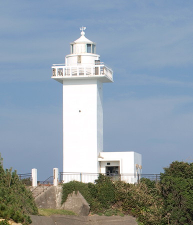
*** Anori Saki (3)
1948 (modern station established 1873). Active; focal plane 33 m (108 ft); white flash every 15 s. 13 m (43 ft) square cylindrical concrete tower with lantern and gallery attached to a small equipment room. Entire lighthouse painted white. A photo is at the top of this page, the Toba Coast Guard Office has a page with several photos, a 2011 photo is available, Trabas has a closeup photo by Jonathon Post, Lighthouse-Japan.com has fine photos, FOAL's page has good photos, Misty's Tour has additional photos, and Google has a street view and a satellite view. Lights were shown here as early as 1681 according to a former Coast Guard Fourth Region page for the station. The 1873 lighthouse, an octagonal wooden tower, was moved several times to escape erosion of the point. After the present lighthouse was built the old tower was relocated to the Museum of Maritime Science in Tōkyō. Forand has a postcard view of the old lighthouse. A lighthouse museum near the tower has historical exhibits including a 1/3 model of the 1873 light. Located on a sharp, east-facing promontory on the south side of the entrance to Matoya Bay about 12 km (7.5 mi) south of the Ise Bay entrance. Accessible by road and a short walk from a parking area. Site open, museum open daily except Tuesdays, tower closed. . ARLHS JPN-021; JCG-2769; Admiralty M6042; NGA 6356.
* Nada Miyauji Shima (1)
Date unknown. Probably inactive; listed by NGA with focal plane 29 m (95 ft); continuous white spotlight. 10 m (33 ft) concrete post carrying a large rectangular lantern structure. Entire lighthouse is white. FOAL's page has photos, another photo is available (#2779, 1/3 the way down the page, and Google has a satellite view. The purpose of this beacon was to shine a light on a white concrete post on an islet at the end of a dangerous reef. However, it appears that the post now has a light of its own. Trabas has a photo and Google has a satellite view of the post light. Accessible by road, but the trail to the lighthouse is not marked. Located on a headland about 2 km (1.25 mi) northwest of Daio Saki. Site open, tower closed. JCG-2779; Admiralty M6036.4; NGA 6380.
* Nakira Kō (Inner Breakwater)
1928. Active; focal plane 13 m (43 ft); green flash every 3 s. 9 m (30 ft) round strongly conical concrete tower, painted white. FOAL's page has photos, Trabas has a closeup photo, Alps Dake has a 2019 photo, and Google has a street view and a satellite view. Since the harbor has been extended greatly by new breakwaters, this light has little navigational value now. It is retained as a historic beacon. Located on a short pier at Nakira, a harbor in the lee of Daio Saki. Accessible by walking the pier. Site open, tower closed. ARLHS JPN-1838; JCG-2780; Admiralty M6038; NGA 6376.
* Nakira Kō Outer Breakwater
1996. Active; focal plane 17 m (56 ft); green light occulting once every 4 s. 11 m (36 ft) round concrete tower attached to a square 1-story concrete equipment room. Entire lighthouse is white. Trabas has a photo, Alps Dake has a 2019 photo, FOAL has photos (second row left and last row right), and Google has a satellite view. Located at the end of the extended east (main) breakwater at Nakira. Accessible by walking the pier. Site open, tower closed. ARLHS JPN-1839; JCG-2780.1; Admiralty M6038.2; NGA 6378.
* Daio Saki (Daiozaki) North
Date unknown. Active; focal plane 27 m (89 ft); continuous white spotlight illuminating the Daio Iwa reef 720 m (0.45 mi) east northeast. 1-story communications equipment building with the light shown through a square window. A photo (#2782, almost halfway down the page) of the building is available, Trabas has a photo, and Google has a satellite view. Located on a promontory about 400 m (1/4 mi) north of the lighthouse (next entry). Site open, tower closed. JCG-2782; Admiralty M6036.2; NGA 6388.
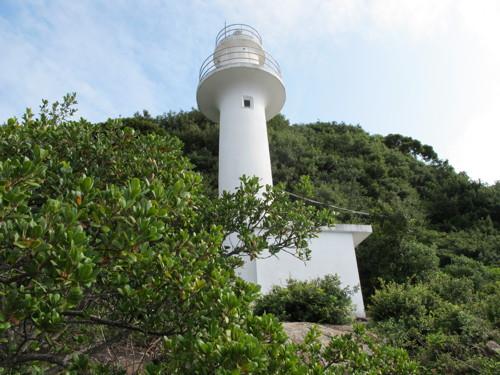
* Daio Saki (Daiozaki)
1927. Active; focal plane 46 m (151 ft); flash every 15 s, alternately red and white; in addition a continuous red light is shown over rocks to the southwest. 23 m (75 ft) round cylindrical concrete tower with lantern and gallery rising from a 2-story concrete keeper's house. Entire lighthouse is white. Tamago Moffle's photo is at right, the Toba Coast Guard Office has a page for the light station, Trabas has a closeup photo by Jonathon Post, Lighthouse-Japan.com has a good closeup photo, FOAL's page has photos, Misty's Tour has photos, Wikimedia has a photo, a 2022 closeup is available, and Google has a street view and a satellite view. This lighthouse was built after the Japanese Navy cruiser Otawa wrecked on nearby reefs. It was damaged during World War II and again by a typhoon in 1959, but it was restored in 1978. Located on a sharp, east-pointing promontory about 30 km (20 mi) south of Toba. Accessible by a 10-minute walk from the waterfront, where parking is available. Site open, tower closed. . ARLHS JPN-053; JCG-2781; Admiralty M6036; NGA 6384.
Daio Saki Light
Daio Saki (Daiozaki) Light, Shima, February 2010
Flickr Creative Commons photo by Tamago Moffle
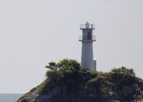
* Mugi Saki
1975. Active; focal plane 28 m (92 ft); white light, 3 s on, 3 s off. 16 m (52 ft) round cylindrical concrete tower with lantern and gallery rising from a 1-story concrete equipment room. Entire lighthouse is white. A photo is at right, the Toba Coast Guard Office has a page for the lighthouse, Trabas has a photo, Lighthouse-Japan.com has outstanding photos of this lighthouse, FOAL has photos (lower part of the page), and Google has a street view and a satellite view. Located on a south-pointing promontory about 6 km (3.5 mi) southwest of Daio Saki. Accessible by a short walk from town; some local guidance may be needed. Site open, tower closed. . ARLHS JPN-376; JCG-2785; Admiralty M6034.2; NGA 6396.
Onaga Iso
Date unknown. Active; focal plane 16 m (52 ft); two green flashes every 6 s. 18 m (59 ft) round cylindrical tower with lantern and gallery, mounted on a slender square concrete pier. Entire lighthouse is green. Trabas has a photo, FOAL has a photo (fourth row on the page), and Bing has an indistinct satellite view. Located at the east end of a large and dangerous reef about 3 km (1.8 mi) southwest of Mugi Saki. Accessible only by boat. Site open, tower closed. JCG-2787; Admiralty M6033.8; NGA 6404.
Fuseda
Date unknown. Active; focal plane 15 m (49 ft); four green flashes in a long-short-long-short pattern every 13 s. 17 m (56 ft) round cylindrical tower with lantern and gallery, mounted on a slender square concrete pier. Entire lighthouse is green. Trabas has a photo, FOAL has a photo (fifth row on the page), Zhengqing Xicheng has a 2021 photo, and Google has a satellite view. Located about 1.6 km (1 mi) south of the fishing port of Wagu. Accessible only by boat. Site open, tower closed. JCG-2791; Admiralty M6033.7; NGA 6408.
* Wagu Kō East Breakwater
Date unknown. Active; focal plane 13 m (43 ft); red light occulting once every 4 s. 9.5 m (31 ft) concrete post attached to a square 1-story concrete equipment shelter. Entire lighthouse is red. Trabas has a closeup photo, FOAL has a photo (second row left), and Google has a satellite view and a distant street view. Located on the original east breakwater of Wagu. Accessible by walking the pier. Site open, tower closed. ARLHS JPN-1872; JCG-2792; Admiralty M6033.5; NGA 6412.

Mugi Saki Light, Shima, February 2009
ex-Panoramio Creative Commons photo by しいね
Iwai Misaki
Date unknown. Active; focal plane 37 m (121 ft); continuous white light. 18 m (59 ft) round white concrete tower with three galleries connected by external ladders. Trabas has a closeup photo, a second photo (#2793, halfway down the page) and a 2003 photo are available, and Google has a satellite view. Located in dense forest above the southwesternmost tip of the hook-shaped Goza peninsula, which shelters Ago Bay. Accessible by a hiking trail but the entrance is completely unmarked and no parking is available. Site open, tower closed. JCG-2793; Admiralty M6033.46; NGA 6416.
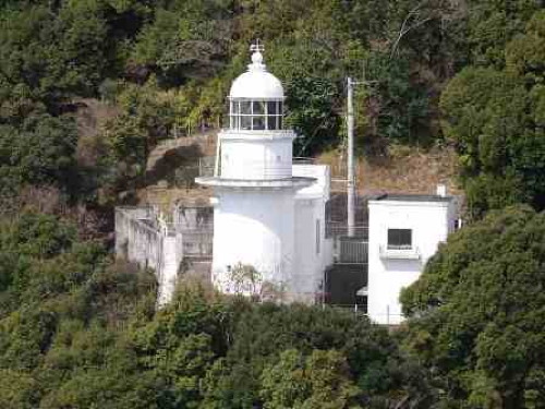
Goza Saki
1971. Active; focal plane 98 m (322 ft); white flash every 10 s. 14 m (46 ft) round cylindrical concrete tower with lantern and gallery attached to a 1-story concrete equipment room. Entire lighthouse is white. Shoji Murakami's photo is at right, Toba Coast Guard Office has a page for the station, Trabas has a photo, FOAL's page has good photos, Lighthouse-Japan.com has photos, a 2023 photo is available, and Google has a satellite view. Located on the heights at the end of the Goza peninsula. Accessible by a hiking trail but the FOAL webmaster needed local guidance to find it. Site open, tower closed. . ARLHS JPN-074; JCG-2794; Admiralty M6032.7; NGA 6420.
Yotorinose (Yotori No Se)
Date unknown. Active; focal plane 9 m (30 ft); two white flashes every 5 s. 9 m (30 ft) round concrete tower, flared at the top, painted black with a red horizontal band. Trabas has a photo and Google has a sea view and a satellite view. Located on a reef in the entrance to a small boat harbor on the north (protected) side of the Goza peninsula. Accessible only by boat. Site open, tower closed. JCG-2801; Admiralty M6033.31; NGA 6428.
Hamashima (Hamajima)
1955. Active; focal plane 20 m (66 ft); white flash every 4 s. 8.5 m (28 ft) round cylindrical white concrete tower with gallery. FOAL has a closeup photo (bottom of the page), another closeup is available, Mizuno Sadao has a view from the sea, Trabas has a view, and Google has a satellite view and a distant street view. Located on Yatori Shima, a small island at the entrance to Hamashima harbor; the islet is connected to land by a breakwater. Site status unknown; the light appears to be accessible by walking the breakwater. ARLHS JPN-1810; JCG-2796; Admiralty M6033; NGA 6440.

Goza Saki Light, Shima, January 2020
Instagram photo by Shoji Murakami

Minamiise Town Lighthouses
Taso Saki
1951. Active; focal plane 97 m (318 ft); two white flashes every 6 s. 12 m (39 ft) slender round concrete tower rising from a 1-story concrete equipment room. Entire lighthouse is white. Lighthouse-Japan.com has a closeup, Trabas has a photo, FOAL has photos (bottom of the page), Masahiko Koyama has a 2023 closeup, and Google has a satellite view. Located on a high promontory separating Ago Bay from Gokasho Bay. Accessible by a hiking trail, but local knowledge will be needed; the Lighthouse-Japan.com webmaster got lost twice looking for this lighthouse. Site open, tower closed. ARLHS JPN-628; JCG-2806; Admiralty M6032; NGA 6448.
* Kazura Wan Entrance
Date unknown. Active; focal plane 14 m (46 ft); two red flashes every 6 s. 10 m (33 ft) round hourglass-shaped concrete tower. Entire lighthouse is red. Trabas has a photo, FOAL has photos (top of the page), a 2022 photo is available, and Google has a satellite view. Kazura Bay is a small harbor sheltered by an island, Kazura Shima. NGA calls the light "Katsurs." Located at the end of the south breakwater at the entrance to the bay. Accessible by walking the pier. Site open, tower closed. ARLHS JPN-1822; JCG-2807; Admiralty M6031; NGA 6452.
Mabana (Mahana) Shima
Date unknown. Active; focal plane 17 m (56 ft); white flash every 4 s. 10 m (33 ft) round concrete tower with gallery. Entire lighthouse is white. Yasuhiro Maeda's photo is at right, Trabas has a photo, a 2022 photo and a small photo (#2812, 2/3 the way down the page) are available, and Google has a satellite view. Located on a rocky island in the center of Gokasho Bay. Accessible only by boat. Site open, tower closed. ARLHS JPN-1828; JCG-2812; Admiralty M6032.4; ex-NGA 6460.
Gokasho Sone Se
Date unknown. Active; focal plane 9.5 m (31 ft); one short and one long red flash every 8 s. 9.5 m (31 ft) round concrete tower, flared at the top. Entire lighthouse is red. Trabas has a photo, another photo (mislabeled #2806, almost 2/3 the way down the page) is available, and Google has a satellite view. Located on the east side of Gokasho Bay about 1 km (0.6 mi) south of Gokashoura. Accessible only by boat. Site open, tower closed. JCG-2809; Admiralty M6032.5; ex-NGA 6468.
Gokasho O Shima
Date unknown. Active; focal plane 15 m (49 ft); three white flashes every 12 s. 10 m (33 ft) round hourglass-shaped concrete tower. Entire lighthouse is white. Trabas has a photo, A Kikuchi has a 2021 aerial view, and Google has a satellite view. Located on a rocky island on the west side of lower Gokasho Bay. Accessible only by boat. Site open, tower closed. ARLHS JPN-1805; JCG-2811; Admiralty M6032.2; NGA 6456.
Mabana Shima Light
Mabana Shima Light, Minamiise, April 2013
ex-Panoramio photo copyright Yasuhiro Maeda; used by permission
Mie Shima (Miesima)
Date unknown. Active; focal plane 67 m (220 ft); white flash every 5 s. 7 m (23 ft) square cylindrical concrete tower rising from a 1-story concrete equipment building. Entire lighthouse is white. A photo (halfway down the page) is available, Trabas has a very distant view, and Bing has a satellite view. Located atop Mie Shima, a steep, rocky island about 6 km (3.5 mi) southeast of Yoshizu. Accessible only by boat and nearly inaccessible in fact. Site and tower closed. ARLHS JPN-348; JCG-2818; Admiralty M6027.4; NGA 6492.
Nayaura Nakanoshima
Date unknown. Active; focal plane 8 m (28 ft); two red flashes every 6 s. 4 m (13 ft) round conical tower painted red. Trabas has a photo, FOAL has a photo (last photo on the page), and Google has a satellite view. Located on a rocky reef at the end of a breakwater in Nayaura Bay. Accessible only by boat. Site open, tower closed. JCG-2819; Admiralty M6027.3; NGA 6496.
* Yoshizu (Yosizu)
1952. Active; focal plane 62 m (203 ft); white light, 3 s on, 3 s off. 10 m (33 ft) hexagonal white concrete tower with gallery. A 2020 closeup is seen at right, Trabas has a closeup photo, FOAL has photos (lower part of the page), Misty's Tour has a twilight photo of the light in action, and Google has a satellite view. Located on a wooded promontory on the west side of the harbor entrance at Yoshizu. Accessible by road and a short trail. Site open, tower closed. . ARLHS JPN-763; JCG-2822; Admiralty M6027; NGA 6512.
* Hoza Kō (Houza Ura)
Date unknown. Active; focal plane 41 m (135 ft); continuous light, white, red or green depending on direction. 7 m (23 ft) square cylindrical white concrete tower, wider at the top. The lights are shown through a square opening near the top. Trabas has a closeup photo, FOAL's page has photos, another photo (#2824, 2/3 the way down the page) is available, and Google has a satellite view. Located atop a wooded bluff marking the entrance to Hoza harbor about 4 km (2.5 mi) south of Yoshizu. Accessible by a trail from the harbor. Site open, tower closed. ARLHS JPN-1814; JCG-2824; Admiralty M6026.4; NGA 6516.
* Kowaura (Kowa)
Date unknown. Active; focal plane 11 m (36 ft); white light, 4 s on, 4 s off. 8.5 m (28 ft) round hourglass-shaped white concrete tower. Trabas has a closeup photo, a 2022 photo and another photo (#2825, 3/4 the way down the page) are available, and Google has a satellite view. Located on a steep point of land on the east side of the entrance to Kowaura harbor. Accessible only by boat. Site and tower closed. ARLHS JPN-1825; JCG-2825; Admiralty M6026.3; NGA 6520.

Yoshizu Light, Minamiise, February 2020
ex-Google Maps photo by South Island

Owase Coast Guard District Lighthouses

Taiki Town Lighthouses
Kome Shima
1970. Active; focal plane 23 m (75 ft); three white flashes every 12 s. 10 m (33 ft) round hourglass-shaped white concrete tower. FOAL has a photo (bottom of the page), a distant photo is available, Trabas also has a distant view, and Google has a satellite view. Located on a small island about 2.5 km (1.5 mi) southeast of the entrance to Nishiki harbor. Accessible only by boat. Site and tower closed. ARLHS JPN-1824; JCG-2826; Admiralty M6024.8; NGA 6540.
#Nishiki Kō East Breakwater
1963. Inactive since 2016 and since removed. This was an 8.5 m (28 ft) concrete post attached to a square 1-story concrete equipment shelter. Entire lighthouse was red. The Coast Guard has a small photo (last lighthouse on the right), but Google's 2021 street view and current satellite view confirm the removal. The light was deactivated in October 2016. Formerly located on the east inner breakwater of the Nishiki fishing port, about 5 km (3 mi) east of Nagashima. Accessible by walking the pier. Site open, tower closed. ARLHS JPN-1840; ex-JCG-2830; ex-Admiralty M6025.6; ex-NGA 6528.
* [Nishiki Kō West Breakwater (2)]
2016 (station established 1986). Active; focal plane 11 m (36 ft); green light, 3 s on, 3 s off. 8 m (26 ft) concrete post. Entire lighthouse is white. Trabas has a photo and Google has a 2021 street view and a satellite view. FOAL has a 2014 photo (third row, left) of the original lighthouse, an 8.5 m (28 ft) concrete post attached to a square 1-story concrete equipment shelter. Located on the end of a breakwater pier at Nishiki. Accessible by walking the pier. Site open, tower closed. ARLHS JPN-1841; JCG-2829.5; Admiralty M6025.7; NGA 6537.
Nishiki
1946. Active; focal plane 44 m (144 ft); white light, 4 s on, 4 s off. 10 m (33 ft) round cylindrical concrete tower with double gallery attached to a small equipment shelter. Entire lighthouse is white. Trabas has a photo, FOAL has several photos (lower half of the page), a closeup photo (#2829, just over 3/4 the way down the page) is available, Misty's Tour has additional photos, and Google has a satellite view and a distant street view. Located on a headland above the west side of the entrance to Nishiki harbor. Accessible by a hiking trail; the FOAL webmaster discovered the unmarked entrance at a break in the highway guardrail. No parking available. Site open, tower closed. ARLHS JPN-418; JCG-2829; Admiralty M6025; NGA 6524.

Kihoku Town Lighthouses
Nagashima (O Isi)
1973. Active; focal plane 21 m (69 ft); two red flashes every 6 s. 9 m (30 ft) round hourglass-shaped white concrete tower with gallery. Entire lighthouse is white. This is quite a rarity in Japan: a white lighthouse showing a red light. Trabas has a photo, the Coast Guard has a small photo (second photo in the lineup), FOAL has a distant view (bottom of the page), Mutao Saka has a photo, and Google has a satellite view. NGA has a typo: "Lsi" for Isi. Located on a rock on the east side of the entrance to Nagashima Wan. Accessible only by boat. Site and tower closed. ARLHS JPN-1845; JCG-2833; Admiralty M6023.8; NGA 6544.
Nagashima Kō
1935. Active; focal plane 15 m (49 ft); green light, 3 s on, 3 s off. 11 m (36 ft) round concrete tower, flared at the top and attached to a small 1-story equipment shelter. Entire lighthouse is white. A drone view is at right, Trabas has a closeup photo, the Coast Guard has a small photo (fourth photo in the lineup), and Google has a street view and a satellite view. Located on a short detached breakwater off the end of the main breakwater of Nagashima harbor. The light was relocated recently when the detached breakwater was built. Accessible only by boat. Site open, tower closed. ARLHS JPN-393; JCG-2836; Admiralty M6024; NGA 6552.
Nagashima Oshima
1954. Active; focal plane 98 m (322 ft); three white flashes every 18 s. 9 m (30 ft) round white concrete tower with double gallery, rising from a small square concrete equipment room. Sibling of the Nishiki lighthouse (see above). The Coast Guard has a small photo (first photo in the lineup), a distant view is available, and Google has a satellite view. Located atop a small island about 4 km (2.5 mi) south of the Nagashima light. Accessible only by boat. Site and tower closed. ARLHS JPN-388; JCG-2832; Admiralty M6022; NGA 6548.
Ūtaga Hana (Utaka Bana)
1969. Active; focal plane 48 m (157 ft); 3 s on, 3 s off. 8 m (26 ft) robust concrete post attached to a small 1-story equipment shelter. Entire lighthouse is white. FOAL has several photos, Trabas has a photo, and Google has a street view and a satellite view. Located on a promontory sheltering the small boat harbor of Shiroura. Accessible by a hiking trail. Site open, tower closed. ARLHS JPN-731; JCG-2838; Admiralty M6022.4; NGA 6560.

Nagashima Kō Light, Kihoku, September 2018
Google Maps photo by ToM
* Shimakatsu (Simakatu, Nakano Hana)
1963. Active; focal plane 53 m (174 ft); white flash every 5 s. 9 m (30 ft) round concrete tower, formerly rising from a 1-story square concrete equipment room. Entire lighthouse is white. Trabas has a photo, a 2017 closeup is available, and Google has a satellite view. Sometime between 2014 and 2017 the equipment room was removed, leaving the tower standing alone. FOAL has several 2014 photos (lower half of the page) showing the original appearance of the lighthouse. Located on the promontory on the north side of Nakano Hana, a ragged peninsula that shelters the east side of Owase Wan, about 8 km (5 mi) northeast of Owase. Accessible by a hiking trail, although the entrance is not clearly marked. Site open, tower closed. ARLHS JPN-559; JCG-2839; Admiralty M6022.2; NGA 6568.

Owase City Lighthouses
Onaso Hana
1967. Active; focal plane 60 m (197 ft); three white flashes every 12 s. 8 m (26 ft) round cylindrical concrete tower, rising from a 1-story square concrete equipment room. Entire lighthouse is white. A 2021 closeup photo is available, FOAL has several distant views (near the bottom of the page), Trabas has a distant view, the Coast Guard has a small photo (first photo in the lineup), and Google has a satellite view. Located atop a very sharp promontory on the north side of the entrance to Owase Wan and the harbor of Owase. Site status unknown, but it appears to be very difficult to reach. . ARLHS JPN-1846; JCG-2843; Admiralty M6012; NGA 6580.
Hikimoto Ura
1978. Active; focal plane 22 m (72 ft); two red flashes every 6 s. 10 m (33 ft) round hourglass-shaped concrete tower. Entire lighthouse is red. Hiro Kato's photo is at right, Trabas has a photo, FOAL has photos (near the bottom of the page), the Coast Guard has a small photo (third photo in the lineup), and Google has a satellite view. Located on a reef on the east side of the entrance to Hikimoto Bay, on the north side of Owase. Accessible only by boat. Site open, tower closed. ARLHS JPN-1813; JCG-2845; Admiralty M6021.5; ex-NGA 6584.
Owase (Owashi) Kō Detached (No. 2) Breakwater
Date unknown (station established 1931). Active; focal plane 14 m (46 ft); green light, 3 s on, 3 s off. 9.5 m (31 ft) concrete post attached to a 1-story square concrete equipment room. Entire lighthouse is white. Trabas has a closeup photo, FOAL's page has a photo, the Coast Guard has a small photo (third photo in the lineup), and Google has a street view and a satellite view. Located at the north end of a detached breakwater protecting the waterfront of Owase. Accessible only by boat. Site open, tower closed. JCG-2852; Admiralty M6017; ex-NGA 6608.
Togashira Shima (Owase)
1956. Active; focal plane 129 m (423 ft); white flash every 4 s. 11 m (36 ft) round strongly conical concrete tower. Entire lighthouse is white. FOAL has several photos (halfway down the page), the Coast Guard has a small photo (last photo in the lineup), Trabas has a distant view, and Google has a satellite view. Located on a very steep slope on a small island at the south side of the entrance to Owase Wan and the harbor of Owase. Accessible only by boat. Site and tower probably closed. ARLHS JPN-1862; JCG-2842; Admiralty M6011; NGA 6620.

Hikimoto Ura Light, Owase, June 2010
Google Maps photo by Hiro Kato
Kuki Kō (Kutsu Saki)
1965. Active; focal plane 35 m (115 ft); white light, 3 s on, 3 s off. 9 m (30 ft) round white concrete tower, rising from a 1-story square building. The building is located in Akanenomori Park behind a small Shinto shrine. This information and another photo are found on the Misty's Lighthouse Tour site. Trabas has a photo, a 2019 photo is available, FOAL's page for the lighthouse has good photos, Lighthouse-Japan.com also has good photos, and Google has a satellite view. Located on a wooded promontory on the south side of the Kuki harbor entrance, about 8 km (5 mi) southeast of Owase. Accessible by a hike of about 30 minutes; local guidance is probably needed. Site open, tower closed. ARLHS JPN-299; JCG-2856; Admiralty M6010.4; NGA 6624.
Miki Saki
1928. Active; focal plane 149 m (489 ft); three white flashes every 30 s. 14 m (46 ft) round cylindrical concrete tower with lantern and gallery, rising from a small 1-story keeper's house. Entire lighthouse is white. This historic light is the best known and most visited lighthouse of the southern Mie coast. A Coast Guard photo is at right, FOAL's page for the station has good photos, Lighthouse-Japan has excellent photos, Trabas has a closeup photo, Misty's Tour also has photos, Google has a street view and a satellite view. Located at the end of a long, rugged peninsula about 15 km (9 mi) southeast of Owase. Accessible by a hiking trail. Parking is available at the trailhead. Site open, tower closed. . ARLHS JPN-352; JCG-2859; Admiralty M6010; NGA 6668.
Kosugi Hana
1959. Active; focal plane 30 m (98 ft); white flash every 5 s. 10 m (33 ft) octagonal cylindrical concrete tower, rising from a 1-story square concrete equipment room. Entire lighthouse is white. FOAL's page has several photos, Lighthouse-Japan.com has a good closeup, Trabas has a distant view, Misty's Tour also has a photo, and Google has a satellite view. Located at the end of a long peninsula projecting into Kosugi Wan about 5 km (3 mi) east of Kosugi. Accessible by hiking the service road. Limited parking is available near the entrance. Site open, tower closed. ARLHS JPN-290; JCG-2860; Admiralty M6009.5; NGA 6652.
Miki Saki Light
Miki Saki Light, Owase
Japanese Coast Guard Owase Office photo (no longer online)
Kata O Saki
1972. Active; focal plane 15 m (49 ft); white light, 3 s on, 3 s off. 8.5 m (28 ft) round hourglass-shaped concrete tower. Entire lighthouse is white. Trabas has a good photo, the Coast Guard has a small photo (fourth photo in the lineup), and Google has an indistinct satellite view. Located on a promontory on the south side of Kata Bay on the south side of Owase. This lighthouse is close to a road but down a steep staircase; photos of it are rare. Limited parking is available near the entrance. Site open, tower closed. ARLHS JPN-1820; JCG-2864; Admiralty M6009.54; ex-NGA 6656.

Kumano City Lighthouses
Niki Shima (Nigishimi, Nikijima)
1953. Active; focal plane 45 m (148 ft); white light, 3 s on, 3 s off. 12 m (39 ft) round cylindrical concrete tower with double gallery, rising from a 1-story square concrete equipment room. Entire lighthouse is white. A photo is at right, Lighthouse-Japan.com has good photos, FOAL's page also has good photos, Trabas has a distant view, Nick Yade has a street view, and Google has a satellite view. Niki Shima is called an island, but in fact it is connected to the mainland by a narrow isthmus. Located at the southwestern point of the "island," off highway 311 about 15 km (9 mi) northeast of Kumano. A hiking trail leads to the lighthouse, but no parking is available. Site open, tower closed. . ARLHS JPN-409; JCG-2865; Admiralty M6009; NGA 6632.
Ino Hana
1958. Active; focal plane 84 m (276 ft); two white flashes every 7 s. 11 m (36 ft) octagonal cylindrical concrete tower, rising from a 1-story octagonal concrete equipment room. Entire lighthouse is white. Lighthouse-Japan.com has photos, FOAL's page has photos, and Bing has a satellite view. This lighthouse marks the approach to the harbor of Kumano. Located at the tip of a peninsula about 6 km (4 mi) east of Kumano. Accessible by hiking, but local guidance will be needed. Site open, tower closed. ARLHS JPN-170; JCG-2868; Admiralty M6008.5; NGA 6640.

Minamimuro District Lighthouse
Udono Kō North Breakwater
Date unknown. Active; focal plane 16 m (52 ft); green flash every 3 s. 11 m (36 ft) round concrete tower, flared at the top, attached to a small equipment shelter. Entire lighthouse is white. Trabas has a closeup photo, the Coast Guard has a small photo (third photo in the lineup), and Google has a satellite view. Udono is a port town on the north side of the Kumano River, which forms the border between Mie and Wakayama Prefectures. Located at the north end of a detached breakwater sheltering the harbor of Udono. Site and tower closed. ARLHS JPN-1871; JCG-2869.8; Admiralty M6007.5; NGA 6678.
Nigi Shima Light
Niki Shima Light, Kumano, August 2011
ex-Panoramio photo copyright satsueisya; permission requested

Information available on lost lighthouses:

Notable faux lighthouses:

Adjoining pages: North: Northern Mie | West: Southern Wakayama

Return to the Lighthouse Directory index | Ratings key

Posted November 5, 2006. Checked and revised August 22, 2023. Lighthouses: 46. Site copyright 2023 Russ Rowlett and the University of North Carolina at Chapel Hill.