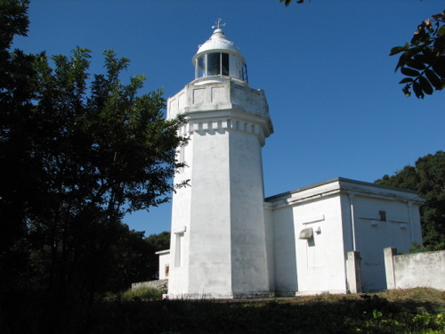
Lighthouses of Japan: Southern Wakayama Prefecture

The nation of Japan, known in Japanese as Nihon or Nippon (日本), occupies an archipelago off the east coast of Asia. The four main islands are Hokkaidō in the north, Honshū (the largest) in the center, Shikoku in the south, and Kyūshū in the southwest. The country includes thousands of other islands of all sizes; among them the Ryūkyū (Nansei) Islands are a long chain extending to the southwest and including the large island of Okinawa, and the Nanpō Islands are another long chain extending south into the Pacific Ocean. Much of Japan is mountainous but the coastal regions are densely populated and urbanized; the country's population is about 126 million.

Japan is divided into 47 prefectures. This page lists lighthouses of the southern part of Wakayama Prefecture, which faces southwest on the Pacific Ocean southeast of Ōsaka. The prefecture includes a large part of the scenic Kii Peninsula, which projects southward into the Pacific and is the southernmost coast of Honshū. This is a rugged and scenic coast marked by a series of major lighthouses.

In Japanese the word for a lighthouse is tōdai or toudai (灯台). The words saki and misaki are for capes and headlands, hana ("nose") is a promontory, hantō is a peninsula, shima (also spelled sima or jima) is an island, bae is a reef, iwa or shi is a rocky reef, amase or se is a shoal, wan is a bay, nada is a sound or basin, kaikyō is a strait, kawa is a river, and or minato is a harbor.

Lighthouses in Japan are operated and maintained by the Japanese Coast Guard's Maritime Safety Agency. On Honshū there is usually at least one Coast Guard Section Office in each prefecture; Wakayama has two, at Tanabe and at Wakayama City. The Tanabe office is responsible for all the lighthouses on this page.

ARLHS numbers are from the ARLHS World List of Lights. JCG numbers are the Japanese Coast Guard's light list numbers. Admiralty numbers are from volume M of the Admiralty List of Lights & Fog Signals. U.S. NGA List numbers are from Publication 112.

General Sources
Lighthouses in Japan - Wakayama
A site providing photos and data for most major Japanese lighthouses.
Lighthouse-Japan.com - Wakayama
Another comprehensive site with photos and notes from visits to many lighthouses.
Form of a Lighthouse - Wakayama
Another site with many photos of Japanese lighthouses and notes on how to find them; cited below as FOAL.
Lighthouse Visits
This site has photos for many lighthouses in this area.
Misty's Japanese Lighthouse Tour - Wakayama
Photos with a few notes in English for lighthouses in all parts of the country.
Online List of Lights - Japan
Photos posted by Alexander Trabas.
Lighthouses in Wakayama Prefecture
Photos by various photographers available from Wikimedia.
Richard Henry Brunton
Wikipedia article on the Scottish engineer who built most of Japan's oldest lighthouses, including the surviving Sugashima Light and the first lighthouse at Anori Saki.
Japan: Modern Lighthouses
Historic postcard views posted by Michel Forand.
Navionics Charts
Navigation chart for the Wakayama coast.
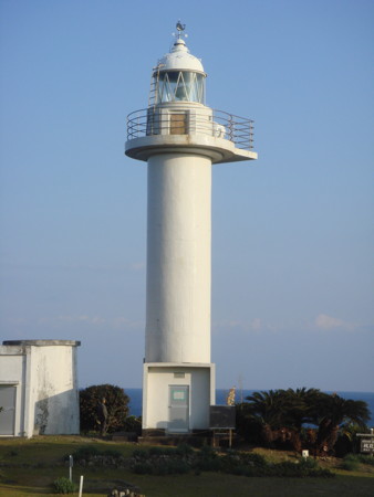
Kantori Saki Light
Kantori Saki Light, Taiji, January 2008
Wikimedia public domain photo by Tarafuku10
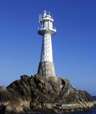
Shingū City Lighthouses
Shingū (Singu) Detached Breakwater South Head
Date unknown. Active; focal plane 16 m (52 ft); two red flashes every 6 s. 10 m (33 ft) round concrete tower with a flared top attached to a small equipment shelter. Entire lighthouse is red. Trabas has a photo and Google has a satellite view and a very distant street view. Located at the south end of the main breakwater of Shingū. Accessible only by boat. Site open, tower closed. ARLHS JPN-1855; JCG-2871.2; Admiralty M6007.3; NGA 6682.
#Shingū (Singu) South Breakwater (1)
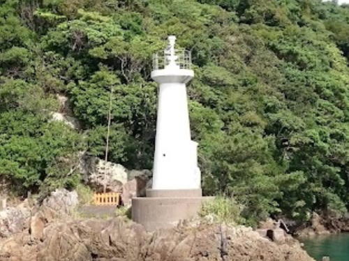
Date unknown. Replaced in 2014. This was a 9.5 m (31 ft) concrete post attached to a square 1-story concrete equipment shelter. Entire lighthouse was white. FOAL's March 2014 photo (next to last row, right) shows that this light was replaced by a small white conical tower (focal plane 13 m (43 ft); green light, 3 s on, 3 s off) on a detached outer breakwater. Trabas has a distant photo and Google has a satellite view. The original light was located at the end of the short south breakwater of Shingū. Probably accessible by walking the pier. Site open, tower closed. ARLHS JPN-1856. Active light: JCG-2873; Admiralty M6007.2; NGA 6684.
Ugui (Ukui, Ugui Koma Saki)
1925. Active; focal plane 53 m (174 ft); white flash every 5 s. 8.5 m (28 ft) round cylindrical concrete tower, rising from a small square 1-story concrete equipment room. Entire lighthouse is white. Lighthouse-Japan.com has photos, FOAL's page also has photos, Trabas has a photo, and Google has a satellite view. The harbor facilities of Ugui are built on an isthmus, at least partially artificial, that connects a hilly, wooded island to the mainland about 10 km (6 mi) south of Shingu. A street view shows the dense vegetation surrounding the lighthouse. There is a hiking trail to the lighthouse but some local knowledge may be needed to find it. Located at the southern tip of the island. Site open, tower closed. . ARLHS JPN-711; JCG-2874; Admiralty M6007; NGA 6688.
Obera Shima
Date unknown. Active; focal plane 19 m (62 ft); white flash every 3 s. 15 m (49 ft) round tapered white tower with gallery. Entire lighthouse is white. Trabas has a photo, FOAL's page for the lighthouse has photos (rows 3-5 on the page), a 2022 view from the sea is available, and Google has a satellite view. Located on a small island about 1.3 km (0.8 mi) south of the Ugui lighthouse. Accessible only by boat. Site open, tower closed. JCG-2876; Admiralty M6006.8; NGA 6696.

Nachikatsuura Town Lighthouses
Katsuo Shima (Katuojima)
Date unknown. Active; focal plane 20 m (66 ft); two white flashes every 7 s. 15 m (49 ft) round white tower with double gallery. Entire lighthouse is white. A Coast Guard photo is at right, FOAL has another good photo (2/3 the way down the page), Trabas has a photo, a 2022 photo is available, and Google has a satellite view. Located on a skerry about 5 km (3 mi) south of the Ugui lighthouse, off Taiji harbor. Accessible only by boat. Site status unknown. ARLHS JPN-1952; JCG-2877; Admiralty M6003; NGA 6708.
Oto Shima
Date unknown. Active; focal plane 16 m (52 ft); white flash every 3 s. 11 m (36 ft) concrete post attached to a square 1-story equipment shelter. Entire lighthouse is white. FOAL has a closeup photo (halfway down the page, on the left), Trabas has a photo, a 2022 photo is available, and Google has a satellite view. Located at the southern tip of a small island at the entrance to Kii Katsuura harbor. Accessible only by boat. Site status unknown. ARLHS JPN-1966; JCG-2878; Admiralty M6004; NGA 6700.
Katsuo Shima Light
Katsuo Shima Light, Taiji
Japanese Coast Guard Fifth District photo
Ketano Hana (Naka Shima)
Date unknown. Active; focal plane 12 m (39 ft); green light, 4 s on, 4 s off. 8.5 m (28 ft) round concrete tower. Entire lighthouse is white. A photo is at right, FOAL has several good photos (upper half of the page), Trabas has a photo, and Google has a satellite view. Located on a promontory at the eastern tip of an island on the west side of the entrance to Kii Katsuura harbor. Accessible only by boat. Site status unknown. JCG-2879; Admiralty M6006; NGA 6704.
* Taiji (Taichi, Taizi) Kō
Date unknown. Active; focal plane 15 m (49 ft); continuous red light with a more intense flash every 6 s. 9 m (30 ft) concrete post attached to a square 1-story concrete equipment shelter. Entire lighthouse is red. Trabas has a closeup photo and Google has a street view and a satellite view. Located at the end of the main (north) breakwater at Taiji. Accessible by walking the pier. Site open, tower closed. ARLHS JPN-1974; JCG-2882; Admiralty M6003.4; NGA 6712.
* Kantori Saki
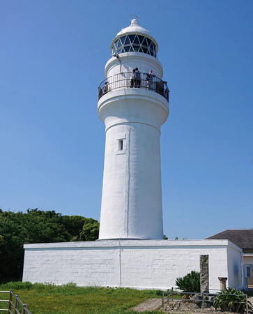
Date unknown (station established 1899). Active; focal plane 41 m (135 ft); white flash every 8 s; in addition a continuous white spotlight (JCG-2885) illuminates a reef 630 m (0.4 mi) to the southeast. 16 m (52 ft) round cylindrical concrete tower with lantern and gallery. Entire lighthouse is white. A photo is at the top of this page, Trabas has a closeup photo, Lighthouse-Japan has photos, FOAL's page for the lighthouse has photos, Kiyoshi Akazawa has a 2020 photo, and Google has a street view and a satellite view. Located on a promontory projecting eastward into the Pacific about 5 km (3 mi) east of Taizi. Accessible by road, but parking is limited. Site open, tower closed. . ARLHS JPN-229; JCG-2884; Admiralty M6002; NGA 6716.

Ketano Hana Light, Nachikatsuura, June 2017
Google Maps photo by tomo .k
Uragami (Urakami) Kō Approach
1986. Active; focal plane 56 m (184 ft); white or red light depending on direction, 3 s on, 3 s off. 8.5 m (28 ft) round cylindrical concrete tower attached to a 1-story equipment building. Entire lighthouse is white. Trabas has a photo, FOAL's page for the lighthouse has excellent photos, and Google has a satellite view. The light guides vessels approaching the narrow fjord leading to Uragami harbor. Located on a steep promontory near Shimosato, about 2.5 km (1.5 mi) south of Taiji. There is a hiking trail to the lighthouse, but some local knowledge will be needed to find it. Site open, tower closed. . JCG-2885.5; Admiralty M6001.5; NGA 6720.

Kushimoto Town Lighthouses
* Kozagawa (Kozakawa, Koza Kawaguchi)
Date unknown (station established 1932). Active; focal plane 11 m (36 ft); red light occulting once every 8 s. 8.5 m (28 ft) concrete post rising from a 1-story equipment building. Lighthouse painted red. Trabas has a good photo, FOAL's page for the light has photos, Michael Ryo has a 2022 photo, and Google has a street view and a satellite view. Located on a rocky point on the east side of the river entrance at Koza, just a few feet off the coastal highway. Easy to find but there's no parking nearby. Site open, tower closed. . ARLHS JPN-1956; JCG-2888; Admiralty M6000; NGA 6732.
* Kushimoto Shinko (Kushimoto Northeast Breakwater)
Date unknown. Active; focal plane 11 m (36 ft); green flash every 3 s. 8.5 m (28 ft) concrete post rising from a 1-story equipment building. Entire lighthouse is white. Trabas has a closeup photo and Google has a street view and a satellite view. Located on the south breakwater of a small boat harbor, northeast of the main harbor of Kushimoto. Accessible by walking the pier. Site open, tower closed. JCG-2899; Admiralty M5996.2; NGA 6736.
Kushimoto Kō North Breakwater
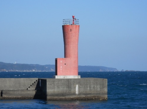
Date unknown. Active; focal plane 13 m (43 ft); red flash every 3 s. 9.5 m (31 ft) round concrete tower with a flared top, attached to a small equipment shelter. Entire lighthouse is red. Trabas has a closeup photo, Kenichiro Asai has 2021 photo, and Google has a street view and a satellite view. Located at the south end of the main breakwater of Kushimoto. Site status unknown. ARLHS JPN-1957; JCG-2897; Admiralty M5996; NGA 6780.
Kushimoto Kō South Breakwater
Date unknown. Active; focal plane 14 m (46 ft); two green flashes every 6 s. 10 m (33 ft) round concrete tower with a flared top, attached to a small equipment shelter. Entire lighthouse is white. Trabas has a closeup photo, Kenichiro Asai has 2021 photo, and Google has a street view and a satellite view. Located at the end of the south breakwater of Kushimoto. Site status unknown. ARLHS JPN-1958; JCG-2896; Admiralty M5996.05; NGA 6740.
Kushimoto North Breakwater Light
Kushimoto Kō North Breakwater Light, Kushimoto
Japanese Coast Guard Tanabe Office photo
* Tojiro (Toziro) Hana
1975. Active; focal plane 12 m (39 ft); continuous red light with two more intense flashes every 6 s. 6.5 m (21 ft) post centered on a square 1-story concrete equipment shelter. Lighthouse covered with red tile. FOAL's page for the harbor lights has photos (lower half of the page), Trabas has a photo, and Google has a satellite view. Located at the west end of Kii Oshima, under the bridge connecting the island to the mainland. There's a good view from an observation platform at the north end of the bridge. Site open, tower closed. ARLHS JPN-1960; JCG-2893; Admiralty M5996.4; NGA 6748.
* Kii Oshima Kō South Breakwater
Date unknown. Active; focal plane 12 m (39 ft); red light, 6 s on, 2 s off. 9.5 m (31 ft) round cylindrical concrete tower. Entire lighthouse is red. Trabas has a closeup photo and Google has a street view and a satellite view. Located at the end of a breakwater at the small boat harbor on the northwest side of Kii Oshima, an island about 6 km (3.5 mi) long lying to the east northeast of Shiono Misaki (Cape Shiono). The island is connected to the mainland by a bridge. Accessible by walking the pier. Site open, tower closed. JCG-2892; Admiralty M5997; NGA 6744.
* Kii Oshima Kō East Breakwater
1983. Active; focal plane 11 m (36 ft); continuous green light with a more intense flash every 5 s. 8.5 m (28 ft) concrete post attached to a square 1-story concrete equipment shelter. Lighthouse covered with white tile. Trabas has a closeup photo, FOAL has a photo (bottom of the page), and Google has a satellite view. Located at the end of a breakwater at the small boat harbor of Kii Oshima. Accessible by walking the pier. Site open, tower closed. JCG-2898; Admiralty M5997.2; NGA 6784.
Toshima (Tojima) Saki
Date unknown. Active; focal plane 10 m (33 ft); white flash every 3 s. 8 m (26 ft) round concrete tower. Entire lighthouse is white. Trabas has a photo, FOAL has a distant view (bottom of the page), and Google has a satellite view. Located at the northernmost point of Kii Oshima, marking the channel between the island and the mainland. A rough trail leads to or near the lighthouse; the entrance is accessible by road but parking is limited. Site status unknown. ARLHS JPN-1980; JCG-2891; Admiralty M5997.3; NGA 6752.
*** Kashino Saki (Kasino Saki, Kii Oshima)
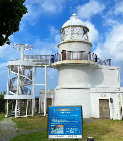
1870 (substantially rebuilt in 1954). Active; focal plane 47 m (154 ft); two white flashes every 20 s. 15 m (49 ft) round cylindrical concrete and stone tower with lantern and gallery. Entire lighthouse is white. A 2023 photo is at right, Trabas has a closeup photo, FOAL's page for the lighthouse has excellent photos, Lighthouse-Japan.com has excellent photos, a great 2021 closeup is available, Nick Yade has a street view, and Google has a satellite view. This lighthouse, designed by Richard Henry Brunton, has the original stone foundation and the original cast iron first order lantern, but a modern concrete section was inserted between the two. Access to the observation deck and lantern is now by an external spiral stairway. A semicircular 1-story keeper's house surrounds the original base. Despite these alterations, this is a historic light station, one of the oldest Western-style lighthouses in Japan. The lighthouse stands at the eastern tip of Kii Oshima; it is the landfall light for the cape for westbound ships. Accessible by a scenic walk of about 1 km (0.6 mi); parking provided. Site and the stairway to the observation platform are open, tower closed. . ARLHS JPN-239; JCG-2889; Admiralty M5998; NGA 6756.

Kashino Saki Light, Kii Oshima, July 2023
Instagram photo by jonnobilife
Myoga Shima
Date unknown. Active; focal plane 16 m (52 ft); white flash every 3 s. 14 m (46 ft) slender round cylindrical white concrete tower with an expanded upper section below the light. Lighthouse-Japan.com has a good photo, FOAL's page for the harbor lights has photos (upper half of the page), Trabas has a photo, a closeup is available, and Google has a street view and a satellite view. (The street view is taken from the unusual spiral bridge that connects Kii Oshima to the mainland.) Located on a rocky promontory on the southeast side of Kii Oshima. Access across the rocky shore may be difficult. Site open, tower closed. . ARLHS JPN-810; JCG-2895; Admiralty M5995.6; NGA 6772.
Uno Shima (U Shima)
Date unknown. Active; focal plane 21 m (69 ft); white flash every 3 s. 14 m (46 ft) slender round cylindrical white concrete tower. FOAL's page for the lighthouse has several good photos, Trabas has a photo, Lighthouse-Japan.com has a photo, Kenichiro Asai has a 2021 photo, and Google has a satellite view. Located on a skerry off the eastern point of the Cape Shiono peninsula. Accessible only by boat, but there is a distant view from the mainland. Site and tower closed. ARLHS JPN-835; JCG-2901; Admiralty M5995; NGA 6768.
**** Shiono (Siono) Misaki (2)
1878 (station established 1873) (Richard Henry Brunton). Active; focal plane 49 m (161 ft); white flash every 15 s; in addition a continuous white spotlight (JCG-2902.1) illuminates a nearby reef. 23 m (75 ft) round stone tower with lantern and gallery. Entire lighthouse is white. A photo is at right, FOAL's page for the lighthouse has very good photos, Trabas has a photo, Lighthouse-Japan.com has lovely photos, a nice closeup photo and a good 2007 photo are available, Wikimedia has several photos, Forand has a historic postcard view, and Google has a street view, a panoramic view from the gallery, and a satellite view. This beautiful and historic lighthouse marks the southernmost point of the island of Honshū. A modern 1-story building houses a lighthouse museum displaying the original first-order Fresnel lens and other artifacts of area lighthouses. The first lighthouse here was a small wood tower. Located at the extreme southern tip of the Kii Peninsula, about 5 km (3 mi) south of Kushimoto. Site open, parking provided, tower open daily. . ARLHS JPN-573; JCG-2902; Admiralty M5994; NGA 6776.
Arita Kō
Date unknown. Active; focal plane 14 m (46 ft); red flash every 3 s. 10 m (33 ft) concrete post attached to a square 1-story concrete equipment room. Lighthouse covered with red tiles. Trabas has a closeup photo and Google has a street view and a satellite view. Located on a detached breakwater in the entrance to Arita harbor, in the lee of Shiono Misaki. Accessible only by boat. Site open, tower closed. ARLHS JPN-1933; JCG-2906.3; Admiralty M5990; NGA 6802.

Shiono Misaki Light, Kushimoto, May 2022
Instagram photo by ___jh_loving

Susami Town Lighthouses
* Esu Saki
1961. Active; focal plane 33 m (108 ft); two white flashes every 10 s. 11 m (36 ft) round hourglass-shaped concrete tower with gallery. Entire lighthouse is white. Trabas has a closeup photo, FOAL's page for the lighthouse has several photos, Hiromi Morikawa has a 2020 closeup, and Google has a satellite view. Located on an island off the tip of a sharp promontory about 4 km (2.5 mi) southeast of Susami. Accessible by a walk of about 1.5 km (1 mi); there is a paved causeway to the island, but it is probably underwater at high tide. Site open, tower closed. . ARLHS JPN-062; JCG-2907; Admiralty M5989; NGA 6804.
* Wabuka Saki (Susami Kō Approach)
1979. Active; focal plane 89 m (292 ft); continuous white spotlight. 9 m (30 ft) round cylindrical white concrete tower; the light is shone through a small window. Trabas has a closeup photo, Lightphotos Visits has a page with photos, and Google has a satellite view. The light illuminates a rocky reef off the point of the cape. Located atop a steep bluff at Wabuka, about 5 km (3 mi) southeast of Susami. Accessible by road, but the entrance to the cape area is unmarked. Site open, tower closed. JCG-2908; Admiralty M5988.7.
Susami
Date unknown. Active; focal plane 58 m (190 ft); white flash every 5 s. 10 m (33 ft) round white concrete tower. Trabas has a closeup photo, FOAL's page for the Susami lights has a distant view (halfway down the page, on the right), and Google has a satellite view. Located on an island that partly shelters the harbor of Susami, about 2 km (1.2 mi) south of the town. A breakwater causeway connects the island to the mainland. Site status unknown. ARLHS JPN-603; JCG-2909; Admiralty M5988; NGA 6808.
Susami Ko
Date unknown. Active; focal plane 25 m (82 ft); continuous light, white, red or green depending on direction. 7 m (23 ft) round cylindrical concrete tower with lantern and gallery; the light is shown through a square window in the front of the lantern room. Entire lighthouse is white. Lighthouse-Japan.com has photos, Trabas has a closeup, FOAL's page for the Susami lights has photos (lower half of the page), Google has a street view, and Bing has a satellite view. Located on a bluff behind the waterfront in Susami. Site and tower closed but the light can be seen from the road. ARLHS JPN-1973; JCG-2910; Admiralty M5988.4; NGA 6812.

Shirahama Town Lighthouses
Ichie (Itie) Saki
1921. Active; focal plane 95 m (312 ft); two white flashes every 30 s. 11 m (36 ft) octagonal concrete tower with lantern and gallery, attached to a 1-story concrete keeper's house. Entire lighthouse is white. A Coast Guard photo is at right, Lighthouse-Japan.com has excellent photos, Trabas has a closeup photo, FOAL's page for the lighthouse also has photos, S. Katsuragi has a 2022 closeup, Forand has a historic postcard view, and Google has a satellite view. Located on a prominent cape about 20 km (12.5 mi) south of Tanabe. Accessible by a moderately strenuous hiking trail. Site open, tower closed. . ARLHS JPN-185; JCG-2912; Admiralty M5986; NGA 6820.
Ichie Saki Light
Ichie Saki Light, Tanabe
Japanese Coast Guard Tanabe Office photo
* Bansho (Bansyo) Hana
1955. Active; focal plane 37 m (121 ft); white light occulting once every 8 s. 8.5 m (28 ft) round concrete tower with gallery, rising from a small 1-story equipment room. Entire lighthouse is white. Trabas has a closeup photo, Lighthouse-Japan has photos, Hisatomo Tatsuki has a closeup street view, and Google has a satellite view. There is a popular observation deck close to the lighthouse. Located on a sharp promontory in Shirahama, about 8 km (5 mi) south of Tanabe. Accessible by a short walk from the nearby Kyōto University Aquarium. Site open, tower closed. . ARLHS JPN-042; JCG-2913; Admiralty M5984; NGA 6824.
Shiso (Siso) Shima
1976. Active; focal plane 14 m (46 ft); white flash every 5 s. 12 m (39 ft) round cylindrical concrete tower with gallery. Entire lighthouse is white. Trabas has a photo, FOAL has several photos (a little over halfway down the page), A. Kikuchi has a 2022 photo, and Google has a satellite view. Located on a reef about 800 m (1/2 mi) west of the Bansho Hana lighthouse. Accessible only by boat, but there is a good view from the mainland. Site and tower closed. ARLHS JPN-587; JCG-2914; Admiralty M5979; NGA 6828.

Information available on lost lighthouses:

Notable faux lighthouses:

Adjoining pages: Northeast: Southern Mie Prefecture | Northwest: Northern Wakayama

Return to the Lighthouse Directory index | Ratings key

Posted November 5, 2006. Checked and revised August 30, 2023. Lighthouses: 30. Site copyright 2023 Russ Rowlett and the University of North Carolina at Chapel Hill.