Lighthouses of Japan: Southern Ishikawa

The nation of Japan, known in Japanese as Nihon or Nippon (日本), occupies an archipelago off the east coast of Asia. The four main islands are Hokkaidō in the north, Honshū (the largest) in the center, Shikoku in the south, and Kyūshū in the southwest. The country includes thousands of other islands of all sizes; among them the Ryūkyū (Nansei) Islands are a long chain extending to the southwest and including the large island of Okinawa, and the Nanpō Islands are another long chain extending south into the Pacific Ocean. Much of Japan is mountainous but the coastal regions are densely populated and urbanized; the country's population is about 126 million.

Japan is divided into 47 prefectures. Ishikawa Prefecture is located on the western coast of Honshū facing the Sea of Japan. The northern half of Ishikawa is the Noto Peninsula, which projects northward into the Sea of Japan and poses a substantial hazard to navigation. The peninsula is rugged and scenic, very different from the sandy, well-populated shores of the southern half of the prefecture. This page includes lighthouses of the southern half of the prefecture, through Shika on the southwestern shore of the Noto Peninsula.

In Japanese the word for a lighthouse is tōdai or toudai (灯台). The words saki and misaki are for capes and headlands, hana ("nose") is a promontory, hantō is a peninsula, shima (also spelled sima or jima) is an island, bae is a reef, iwa or shi is a rocky reef, amase or se is a shoal, wan is a bay, nada is a sound or basin, kaikyō is a strait, kawa is a river, and or minato is a harbor.

Lighthouses in Japan are operated and maintained by the Japanese Coast Guard's Maritime Safety Agency. On Honshū there is at least one Coast Guard Section Office in each prefecture, often two or more. In Ishikawa there are two offices, at Kanazawa in the west and Nanao in the east; all the lights on this page are maintained by the Kanazawa Office.

A note on the Sea of Japan/East Sea controversy: The Directory takes no side in any international dispute; it makes use of the terminology, names, and spellings as they currently exist in each area covered. The sea between Japan and Korea is called the Sea of Japan on the pages for Japan and the East Sea on the pages for Korea.

ARLHS numbers are from the ARLHS World List of Lights. JCG numbers are the Japanese Coast Guard's light list numbers. Admiralty numbers are from volume M of the Admiralty List of Lights & Fog Signals. U.S. NGA List numbers are from Publication 112.

General Sources
Lighthouses in Japan - Ishikawa
A site providing photos and data for most major Japanese lighthouses.
Lighthouse-Japan.com - Ishikawa
A site providing photos and data for most major Japanese lighthouses.
Form of a Lighthouse - Ishikawa
Another site with many photos of Japanese lighthouses; this source is cited below as FOAL.
Lighthouse Visit
Another good source of lighthouse photos.
Online List of Lights - Japan
Photos by various photographers posted by Alexander Trabas.
Misty's Japanese Lighthouse Tour - Ishikawa
Photos and a few notes for lighthouses in all parts of the country.
Lighthouses in Ishikawa Prefecture
Photos by various photographers available from Wikimedia.
Ninth Region Lighthouse Location Map
This interactive map links to photos and descriptions (in Japanese) of the major lighthouses of the Ninth Coast Guard Region, including Ishikawa, Toyama, and Niigata Prefectures.
Kanazawa Lighthouses
Posted by the Kanazawa Coast Guard Office, links to pages on three major lighthouses of the area.
Navionics Charts
Navigation chart for western Honshū.


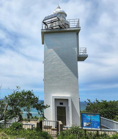
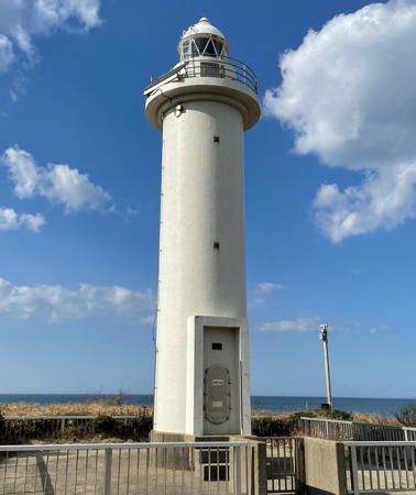
Kasa Misaki Light, Kaga, May 2022
Google Maps photo by ポゲ (Poge)
Kaga City Lighthouses
Shioya (Sioya) Kō
1999. Active; focal plane 12 m (39 ft); two green flashes every 5 s. 8.5 m (28 ft) concrete post attached to a square 1-story equipment shelter. Entire lighthouse is white. FOAL's page for the lighthouse has photos, Lighthouse Visit also has a page with photos, Trabas has a closeup, and Google has a satellite view and a distant street view. Located on the detached outer breakwater at Shioya harbor, on the border between Ishikawa and Fukui prefectures. Accessible only by boat. Site open, tower closed. ARLHS JPN-1204; JCG-1081.5; Admiralty M7239.5; NGA 2716.
* Kasa Misaki (Hashidate Kō, Hasitate Kō)
1950. Active; focal plane 54 m (177 ft); three white flashes every 13 s. 15 m (49 ft) square cylindrical concrete tower with lantern and gallery. Entire lighthouse is white. A 2022 photo is at the top of this page, Trabas has a closeup, Shigeru Hanatani has a 2018 photo, the Coast Guard has a page with an aerial photo of this beautiful site, Lighthouse-Japan.com also has a page for the lighthouse, FOAL's page has good photos, a 2022 closeup is available, and Google has a satellite view. Located at the end of a wooded promontory about 5 km (3 mi) north of Kaga. Accessible by a popular hiking trail about 1 km (0.6 mi) in length. Parking provided. Site open, tower closed. . ARLHS JPN-234; JCG-1082; Admiralty M7237; NGA 2720.
Hashidate Kō West Outer Breakwater
1993. Active; focal plane 13 m (43 ft); red flash every 3 s. 8.5 m (28 ft) concrete post centered on a square 1-story equipment shelter. Entire lighthouse is red. FOAL has additional photos (halfway down the page), Lighthouse Visit has photos, Trabas has a closeup, and Google has a satellite view and a very distant street view. Located at the end of a detached section of the main (west) breakwater of Hashidate. Accessible only by boat. Site open, tower closed. ARLHS JPN-1212; JCG-1084.5; Admiralty M7237.3.
Hashidate Kō West Inner Breakwater
1993. Active; focal plane 9 m (30 ft); red flash every 4 s. 7.5 m (25 ft) concrete post centered on a conical concrete base. Entire lighthouse is red. Trabas has a closeup photo, FOAL has additional photos (next to last row on the page), and Google has a satellite view and a distant street view. Located at the end of a detached section of the main (west) breakwater of Hashidate. Accessible only by boat. Site open, tower closed. JCG-1085; Admiralty M7238; NGA 2724.
Hashidate Kō Outer Breakwater
1985. Active; focal plane 15 m (49 ft); two green flashes every 6 s. 10 m (33 ft) round white concrete tower with a flared top. FOAL has a photos (halfway down the page), Lighthouse Visit has a photo (top of the page), Trabas has a photo, and Google has a satellite view and a distant street view. Located on the outermost of a series of short breakwaters at Hashidate. Accessible only by boat. Site open, tower closed. ARLHS JPN-1214; JCG-1083.5; Admiralty M7237.2; NGA 2732.
Hashidate Kō Northeast Breakwater
1968. Active; focal plane 14 m (46 ft); green flash every 3 s. 11 m (36 ft) concrete post attached to a square 1-story equipment shelter. Entire lighthouse is white. FOAL has additional photos (near the bottom of the page), Lighthouse Visit has a photo, Trabas has a closeup, and Google has a satellite view and a distant street view. Located at the west end of a detached breakwater of Hashidate. Accessible by walking the pier. Site open, tower closed. ARLHS JPN-1213; JCG-1084; Admiralty M7237.4; NGA 2728.

Komatsu City Lighthouse
* Ataka
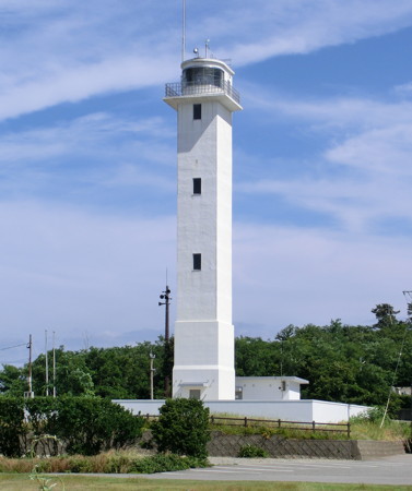
1980. Active; focal plane 22 m (72 ft); white light, 3 s on, 3 s off. 16 m (52 ft) round cylindrical concrete tower with lantern and gallery. Entire lighthouse is white. A 2021 photo is at right, Trabas has a good photo, Lighthouse-Japan.com has a page with fine photos, FOAL's page has several photos, Lighthouse Visit has photos, Misty's Tour has a photo, and Google has a street view and a satellite view. This lighthouse guards the entrance to the harbor of Ataka, a suburb of the inland city of Komatsu. Located on the south side of the entrance; parking is available nearby. Site open, tower closed. . ARLHS JPN-030; JCG-1087; Admiralty M7236.4; NGA 2736.

Ataka Light, Komatsu, March 2021
Instagram photo by koro0621

Hakusan City Lighthouse
* Mikawa
Date unknown. Active; focal plane 25 m (82 ft); white flash every 4 s. 15 m (49 ft) round cylindrical concrete tower with lantern and gallery. Entire lighthouse is white. A 2020 photo is at right, FOAL's page for the lighthouse has several good photos, Lighthouse Visit has photos, Trabas has a closeup, a 2019 closeup is avilable, and Google has a street view and a satellite view. Southern Ishikawa is one of the very few places in Japan with a long, straight, level coast and coastal roads parallel to the beach. This lighthouse is beside the Hokuriku Expressway in Mikawa. Accessible by a walk of about 500 m (0.3 mi) on the beach; parking is available at a small park north of the lighthouse. Site open, tower closed. . ARLHS JPN-351; JCG-1088; Admiralty M7236; NGA 2740.

Kanazawa City Lighthouses
Kanazawa Kō West Breakwater
Date unknown. Active; focal plane 13 m (43 ft); red flash every 4 s. 10 m (33 ft) concrete post attached to a square 1-story equipment shelter. Entire lighthouse is red. Trabas has a closeup photo, Lighthouse Visit has a photo, FOAL has photos, and Google has a satellite view. Located near but not at the end of the west breakwater of Kanazawa. Accessible only by boat; this pier is closed to walkers. Site and tower closed. ARLHS JPN-1220; JCG-1089; Admiralty M7234; NGA 2744.
* Kanazawa Kō East Breakwater
1976. Active; focal plane 13 m (43 ft); green light, 3 s on, 3 s off. 9.5 m (31 ft) concrete post attached to a square 1-story equipment shelter. Entire lighthouse is white. Trabas has a closeup photo, Lighthouse Visit has a photo, FOAL has photos, Matsumoto-pota Masa has a photo, and Google has a satellite view. Located near at the end of the original east breakwater of Kanazawa. Accessible by walking the pier. Site open, tower closed. ARLHS JPN-1219; JCG-1090; Admiralty M7234.4; NGA 2748.

Mikawa Light, Hakusan, June 2020
Google Maps photo by system 7
* Ōno (Kanazawa)
1934. Active; focal plane 34 m (112 ft); white flash every 10 s. 26 m (85 ft) square cylindrical concrete tower with lantern and gallery, rising from the landward end of a large 1-story Coast Guard office building. The lighthouse is white. A photo is at right, the Coast Guard has a page with a photo of an open house at the lighthouse, Lighthouses of Japan also has a page for the lighthouse, Lighthouse-Japan.com has a page with several photos, FOAL's page has photos, Trabas has a closeup, Wikimedia has Fujitani Yoshihide's 2013 photo, and Google has a street view and a good satellite view. According to the Coast Guard page, posts were used at the harbor entrance as early as 1884. Ōno is the seaport associated with the city of Kanazawa; it is both an industrial port and a large fishing port. The lighthouse is on the south side of the harbor entrance, behind a bridge that carries traffic onto an island in the entrance. Site open, tower closed. . ARLHS JPN-461; JCG-1091; Admiralty M7232; NGA 2752.
Ōno Kō Outer (West) Breakwater
Date unknown. Active; focal plane 13 m (43 ft); two red flashes every 6 s. 10 m (33 ft) concrete post attached to a square 1-story equipment shelter. Entire lighthouse is red. Lighthouse Visit has a photo, FOAL has a distant view (second photo on the page), Trabas has a closeup, and Google has a satellite view. Located near but not at the end of the west breakwater of Ōno. Accessible only by boat (this is not a walkable breakwater). Site status unknown. ARLHS JPN-1229; JCG-1092; Admiralty M7233; NGA 2760.
Ōno Kō West (Inner) Breakwater
Date unknown. Active; focal plane 11 m (36 ft); red flash every 3 s. 9.5 m (31 ft) concrete post attached to a square 1-story equipment shelter. Entire lighthouse is red. FOAL has photos (halfway down the page), Lighthouse Visit has a photo, Trabas has a closeup, and Google has a satellite view. Located on a short spur of the west breakwater of Ōno. Site and tower closed (breakwater is fenced). ARLHS JPN-1228; JCG-1093; Admiralty M7233.2; NGA 2756.
* #Ōno East Breakwater (1)
Date unknown. Replaced about 2015. This was an 8.5 m (28 ft) round hourglass-shaped concrete tower. Entire lighthouse was white. The light is missing from Google's satellite view and Lighthouse Visit's 2016 photos show that the lighthouse was replaced by a smaller light (focal plane 11 m (36 ft); green flash every 3 s). Located on a corner of the quay on the east side of the entrance to Ōno. Site open, tower closed. Active light: JCG-1094; Admiralty M7232.4; NGA 2764.
Ōno Light
Ōno Light, Kanazawa, June 2012
ex-Panoramio Creative Commons photo by yuzy0826

Kahoku City Lighthouse
* Shiroo
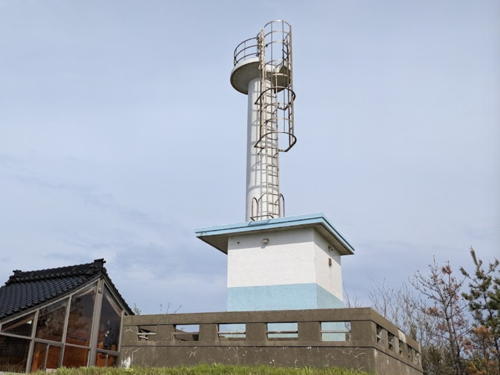
Date unknown (station established 1914). Inactive since 2018. 10 m (33 ft) concrete post attached to a square 1-story concrete equipment building. Lighthouse covered with tiles colored white with light blue trim. Hiroki Nakayama's 2023 photo is at right, Masahiro Hashimoto has a 2018 photo, Lighthouse-Japan.com has a page with several photos, FOAL's page has two closeup photos, Misty's Tour has a nighttime photo, Lighthouse Visit has photos, and Google has a 2023 street view and a satellite view. A Shinto shrine is adjacent to the lighthouse. According to the FOAL webmaster the lighthouse was sold to the town and will be preserved. This lighthouse is not located on a cape or at a harbor; it is on a bluff about 300 m (1/5 mi) north of the Noto Expressway's interchange with highway 56 in Kahoku. Parking is available nearby. Site open, tower closed. . ARLHS JPN-584; ex-JCG-1095; ex-Admiralty M7230; NGA 2768.

Note: The remaining lighthouses of Ishikawa Prefecture are on the thumb-shaped Noto Peninsula (Noto-Hantō), which projects almost 100 km (60 mi) northward into the Sea of Japan.

Hakui City Lighthouses
* Taki Kō Breakwater
Date unknown (station established 1930). Active; focal plane 12 m (39 ft); green light, 3 s on, 3 s off. 10 m (33 ft) concrete post light attached to a square 1-story concrete equipment building. Entire lighthouse is white. Trabas has a closeup photo, Lighthouses of Japan also has a page for the lighthouse, FOAL has a photo, Lighthouse Visit has a photo, Hải Nguyễn Thanh has a closeup street view, and Google has a satellite view and a distant street view. Located at the end of the main (west) breakwater at Takimachi. Accessible by walking the pier. Site open, tower closed. ARLHS JPN-619; JCG-1096; Admiralty M7225; NGA 2772.

Shiroo Light, Kahoku, April 2023
Google Maps photo by Hiroki Nakayama
* Taki Saki
1966. Active; focal plane 18 m (59 ft); white light occulting twice every 6 s. 10 m (33 ft) square cylindrical concrete tower, attached to a small 1-story concrete equipment shed. The lighthouse is white except for a broad light blue band at the base. Lighthouse-Japan.com has a page with good photos, FOAL's page has closeup photos, Lighthouse Visit has photos, Misty's Tour has a closeup photo, a 2019 photo is available, Trabas has a closeup drone view, and Google has a satellite view. Located on a promontory just north of Taki and about 20 km (13 mi) north of Takamatsu. Accessible by a short walking path. Site open, tower closed. . ARLHS JPN-620; JCG-1098; Admiralty M7224; NGA 2780.

Shika Town Lighthouses
Abuka Kō
Date unknown. Active; focal plane 11 m (36 ft); continuous green light with a more intense flash every 5 s. 8.5 m (28 ft) concrete post rising from a square 1-story equipment shelter. Entire lighthouse is white. Trabas has a closeup photo, FOAL has photos, Osamu Takada has a photo, and Google has a street view and a satellite view. Located at the end of the main breakwater at Abuka harbor about 10 km (6 mi) north of Taki Saki. Site status unknown. JCG-1100; Admiralty M7221.6; NGA 2788.
* Fukūra (Hukura) (3)
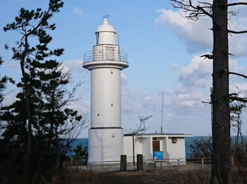
1954 (station established 1905). Active; focal plane 28 m (92 ft); white flash every 12 s. 16 m (52 ft) round cylindrical concrete tower with lantern and gallery, attached to a 1-story concrete equipment building. Entire lighthouse is white. Kensuke Shiraishi's photo is at right, Trabas has an excellent photo, Lighthouses of Japan also has a page for the lighthouse, FOAL has a page with photos, Lighthouse-Japan.com has a page with excellent photos, Misty's Tour has a photo, and Google has a street view and a satellite view. Located on a bluff near Fukūra; accessible by a short walk but some local knowledge may be needed to find the trail. Site open, tower closed. . ARLHS JPN-1211; JCG-1101; Admiralty M7220; NGA 2792.


Fukūra Light, Shika, February 2020
Google Maps photo by Kensuke Shiraishi

* Fukūra (Hukura) (1)
1876. Inactive since 1905. 5 m (17 ft) square pyramidal wood tower with lantern. Lighthouse painted white. Kazumi Yamamoto's photo is at right, FOAL has a page with a photo, Debutcho Kantoku has a 2018 photo, a 2010 closeup is available, Yutaka Ito has a closeup photo, and Google has a street view and a satellite view. This diminutive tower is a very rare survivor from the earliest days of Western-style lighthouses in Japan. It has been preserved in Fukūra village but has been reconstructed several times, most recently in 1938. Site open, tower closed. .
* Fukūra Kō (Mo Saki) Range Rear
1950. Active; focal plane 24 m (79 ft); continuous red light. 9 m (30 ft) white concrete post attached to a square 1-story white concrete equipment building. The light is provided by two vertical neon tubes. Trabas has a photo and Google has a satellite view. The front light (ARLHS JPN-1223, JCG-1102) is on a similar 13 m (43 ft) post but without the equipment building; it is across the street, 90 m (295 ft) due west of the rear light. Located on a bluff above the harbor, a short distance north of the main lighthouse. Site open, tower closed. JCG-1103; Admiralty M7221.1; NGA 2808.
Togi Kō
Date unknown. Active; focal plane 12 m (39 ft); two green flashes every 6 s. 9 m (30 ft) white concrete post attached to a square 1-story white concrete equipment building. Trabas has a closeup photo, FOAL has additional photos and Google has a street view and a satellite view. Located at the end of a detached breakwater at Togi, a small port about halfway between the Fukūra and Ama Saki lighthouses. Accessible only by boat. ARLHS JPN-1233; JCG-1104; Admiralty M7216; NGA 2816.
* Kazanasi Kō
1952. Active; focal plane 14 m (46 ft); green light, 3 s on, 3 s off. 9.5 m (31 ft) white concrete post attached to a square 1-story white concrete equipment building. Trabas has a closeup photo, FOAL's page has photos and Google has a satellite view. Located at the end of the south (main) breakwater of Kazanasi harbor, about 2 km (1.2 mi) southwest of the Togi lighthouse. Site open, tower closed. ARLHS JPN-1221; JCG-1106; Admiralty M7214; NGA 2812.

Old Fukura Lighthouse, Fukūra, August 2019
Google Maps photo by Kazumi Yamamoto
* Ama Saki
1953. Active; focal plane 28 m (92 ft); white light, 3 s on, 3 s off. 16 m (52 ft) round cylindrical concrete tower. Entire lighthouse is white. FOAL's page for the lighthouse has several closeup photos, Lighthouse-Japan.com has a page with several photos, Trabas has a closeup, a 2022 photo is available, Misty's Tour has additional photos, and Google has a satellite view. Ama Saki, the westernmost point of the Noto Peninsula, is a high promontory about 25 km (15 mi) north of Hakui. Located on the point of the cape. Accessible by a narrow service road. Site open, tower closed. . ARLHS JPN-016; JCG-1107; Admiralty M7213; NGA 2820.
* #Noto Akasaki Kō (1)
1976. Removed after earthquake damage. This was an 8.5 m (28 ft) white concrete post attached to a square 1-story white concrete equipment building. In May 2010 the lighthouse (like the breakwater) had a distinct lean caused by an earthquake. Sometime thereafter the lighthouse was removed, the pier was repaired, and a simple post was installed for the light (focal plane 12 m (39 ft); green flash every 3 s). FOAL has 2018 photos of the new light, Trabas also has a photo, and Google has a street view and a satellite view. Located at the end of the main breakwater at Akasaki, about 1 km (0.6 mi) north of Ama Saki. Accessible by walking the pier. Site open, tower closed. ARLHS JPN-1226. Active light: JCG-1108; Admiralty M7212.4; NGA 2824.

Information available on lost lighthouses:

Notable faux lighthouses:

Adjoining pages: North: Northern Ishikawa | South: Kyōto and Fukui

Return to the Lighthouse Directory index | Ratings key

Posted April 2, 2007. Checked and revised December 17, 2023. Lighthouses: 25. Site copyright 2023 Russ Rowlett and the University of North Carolina at Chapel Hill.