Lighthouses of Japan: Akita

The nation of Japan, known in Japanese as Nihon or Nippon (日本), occupies an archipelago off the east coast of Asia. The four main islands are Hokkaidō in the north, Honshū (the largest) in the center, Shikoku in the south, and Kyūshū in the southwest. The country includes thousands of other islands of all sizes; among them the Ryūkyū (Nansei) Islands are a long chain extending to the southwest and including the large island of Okinawa, and the Nanpō Islands are another long chain extending south into the Pacific Ocean. Much of Japan is mountainous but the coastal regions are densely populated and urbanized; the country's population is about 126 million.

Japan is divided into 47 prefectures. This page lists lighthouses of Akita Prefecture on the northwestern coast of Honshū. Akita Prefecture faces west on the Sea of Japan with a coastline about 100 km (60 m) in length. Much of the prefecture is mountainous.

In Japanese the word for a lighthouse is tōdai or toudai (灯台). The words saki and misaki are for capes and headlands, hana ("nose") is a promontory, hantō is a peninsula, shima (also spelled sima or jima) is an island, bae is a reef, iwa or shi is a rocky reef, amase or se is a shoal, wan is a bay, nada is a sound or basin, kaikyō is a strait, kawa is a river, and or minato is a harbor.

Lighthouses in Japan are operated and maintained by the Japanese Coast Guard's Maritime Safety Agency. On Honshū there is usually one Coast Guard Section Office in each prefecture. Lighthouses of Akita Prefecture are maintained by the Akita office.

A note on the Sea of Japan/East Sea controversy: The Directory takes no side in any international dispute; it makes use of the terminology, names, and spellings as they currently exist in each area covered. The sea between Japan and Korea is called the Sea of Japan on the pages for Japan and the East Sea on the pages for Korea.

ARLHS numbers are from the ARLHS World List of Lights. JCG numbers are the Japanese Coast Guard's light list numbers. Admiralty numbers are from volume M of the Admiralty List of Lights & Fog Signals. U.S. NGA List numbers are from Publication 112.


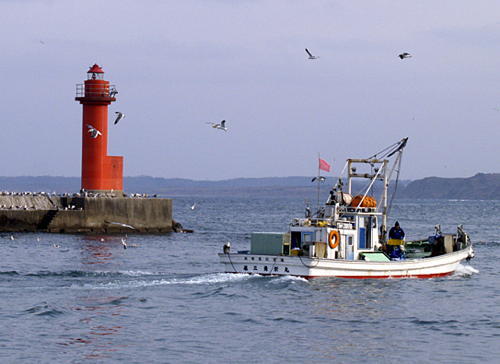
Nyūdō Saki Light, Oga, October 2016
Flickr Creative Commons photo by Sek Keung Lo

General Sources
Lighthouses in Japan - Akita
A site providing photos and data for most major Japanese lighthouses.
Lighthouses-Japan.com - Akita
Another comprehensive site with photos and notes from visits to many lighthouses.
Lighhouses - Akita
Another site with many photos and notes from visits to lighthouses; cited below as FOAL.
Lighthouse Visits
This site has photos for many lighthouses in this area.
Misty's Japanese Lighthouse Tour - Akita
Photos and brief notes in English for lighthouses in all parts of the country.
Kiso's Lighthouses
This site has many excellent photos of Japanese lighthouses.
Second Region Lighthouse Story
Posted by the Coast Guard region office in Aomor, an interactive map linking to information on the major lighthouses.
Akita Section Lighthouse Information
Information and photos posted by the Akita office of the Japanese Coast Guard.
Lighthouses in Akita Prefecture
Photos by various photographers available from Wikimedia.
Online List of Lights - Japan
Photos by various photographers posted by Alexander Trabas.
Navionics Charts
Navigation chart for Akita.

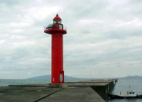
Kitaura Kō Detached Breakwater Light, Oga, July 2007
Wikimedia (ex-Panoramio) Creative Commons photo by Ryuetsu Kato
Nikaho City Lighthouse
* Konoura (Gimpo) Kō
1938. Active; focal plane 18 m (59 ft); white flash every 4 s. 11 m (36 ft) concrete post rising from a a square 1-story concrete equipment room. Entire lighthouse is white. A Coast Guard photo is at right, Atsushi Taguchi has a 2021 photo, a 2007 closeup photo is available, FOAL has several photos, and Google has a street view and a satellite view. Located on the waterfront of Konoura. Accessible by an arched footbridge. Site open, tower closed. . ARLHS JPN-1037; JCG-1390; Admiralty M7072; NGA 3520.
* Konoura (Gimpo) Kō North Breakwater
Date unknown. Active; focal plane 14 m (46 ft); two green flashes every 6 s. 8.5 m (28 ft) concrete post rising from a a square 1-story concrete equipment room. Entire lighthouse is white. FOAL has photos (near the bottom of the page) and Google has a satellite view. Located on a breakwater at Konoura. Site open, tower closed. ARLHS JPN-1038; JCG-1389; Admiralty M7072.4; NGA 3524.
#Hirasawa Kō West Jetty
1962. Inactive since 2009 and subsequently demolished. This was an 8.5 m (28 ft) concrete post rising from a a square 1-story concrete equipment room. Entire lighthouse is red. Bing has an indistinct satellite view of the location. The Hirasawa breakwaters were extended and the lights were replaced by the simple post lights seen in FOAL's 2015 photos. Hirasawa Kō is the harbor of Nikaho City. Located at the end of the west inner breakwater. Site status unknown. ARLHS JPN-1032; ex-JCG-1392; ex-Admiralty M7071; ex-NGA 3532.
#Hirasawa Kō East Breakwater
Date unknown. Inactive since 2009 and subsequently demolished. This was an 11 m (36 ft) concrete post rising from a a square 1-story concrete equipment room. Entire lighthouse was white. Bing has an indistinct satellite view of the former location of the light. The active light (focal plane 12 m (39 ft); green flash every 4 s) was moved to a post at the end of the extended breakwater. Located at the original end of the west breakwater. Site status unknown. ARLHS JPN-1031. Active light: JCG-1391; Admiralty M7070; NGA 3528.
Konoura Light
Konoura Kō Light, Nikaho
Japanese Coast Guard Akita Office photo

Yurihonjō City Lighthouses
Honjō (Yurihonjō) Breakwater
Date unknown. Active; focal plane 14 m (46 ft); green light, 2 s on, 2 s off. 14 m (46 ft) concrete post rising from a a square 1-story concrete equipment room. Entire lighthouse is white. Lighthouse Visits has a page for the light, Atsushi Taguchi has a 2021 photo, and Google has a satellite view. Located at an elbow of the main breakwater at Yurihonjō, marking the north side of the entrance to the Koyoshi River and the south side of the entrance to the port. Site and tower closed. ARLHS JPN-1033; JCG-1393; Admiralty M7069.6; NGA 3540.
#Honjō (Honzyo, Yurihonjō)
1968. Inactive since 2009 and Google's satellite view shows that the lighthouse has been removed. This was an 11 m (36 ft) octagonal hourglass-shaped white concrete tower. Lighthouse of Japan has a page with photos, Lighthouse-Japan.com also has a photo, and a 1985 photo is available. The light was deactivated in November 2009. Located on a bluff about 2 km (1.25 mi) northeast of the Honjō waterfront. Site open, tower closed. ARLHS JPN-776; ex-JCG-1394; ex-Admiralty M7069.4; ex-NGA 3536.
#Matsuga Saki
1958. Inactive since 2017 and later removed. 11 m (36 ft) round cylindrical concrete tower mounted on a square concrete equipment building; no lantern. Lighthouse of Japan has a page with photos taken in 2008, Lighthouse-Japan.com also has a photo, and FOAL's page has 2015 photos. Google's satellite view and October 2019 street view confirm the removal of the lighthouse following its deactivation in December 2017. Matsuga Saki means Pine Cape. Located on a bluff about 8 km (5 mi) north of Honjō. Site open, tower closed. ARLHS JPN-777; ex-JCG-1395; ex-Admiralty M7069; NGA 3544.

Akita City Lighthouses
The prefectural capital of Akita is a city of about 300,000 residents.
Akita Kō South Breakwater
1986. Active; focal plane 19 m (62 ft); two red flashes every 5 s. 16 m (52 ft) round cylindrical concrete tower with lantern and gallery, painted bright red. FOAL's page has a distant view and Google has a satellite view. The breakwater has been extended and there is a new light (JCG-1395.6; Admiralty M7066.8) at the end of the extension. Bing's satellite view shows the new breakwater but not the new light. Located on the outer breakwater of Akita. Site and tower closed. ARLHS JPN-1026; JCG-1395.8; Admiralty M7066.5; NGA 3548.
Akita Kō South Breakwater Inner Head
Date unknown. Active; focal plane 15 m (49 ft); red flash every 5 s. 11 m (36 ft) concrete post rising from a square 1-story concrete equipment room. Entire lighthouse is red. FOAL's page has distant views (near the bottom of the page) and Google has a satellite view. Located at the end of the original south breakwater of Akita. Site status unknown. ARLHS JPN-1028; JCG-1397; Admiralty M7066; NGA 3552.
Akita Kō East Inner Breakwater
Date unknown. Active; focal plane 13 m (43 ft); green light, 3 s on, 3 s off. 11 m (36 ft) concrete post rising from a a square 1-story concrete equipment room. Entire lighthouse is white. FOAL's page has photos (third and fourth rows, left) and Google has a satellite view. Located at the end of the original east (really north) breakwater of Akita. Site status unknown. ARLHS JPN-1027; JCG-1396; Admiralty M7067; NGA 3556.
Akita South Breakwater Light
Akita South Breakwater Light, Akita
Japanese Coast Guard Akita Section photo

Oga City Lighthouses
Funagawa South Breakwater
Date unknown. Active; focal plane 15 m (49 ft); green light, 2 s on, 2 s off. 14 m (46 ft) round cylindrical concrete tower with lantern and gallery. Entire lighthouse is white. FOAL's page has a photo (bottom of the page) and Google has a satellite view and a very distant street view. Located at the end of the outer breakwater at the Akita National Oil Terminal. Site and tower closed. ARLHS JPN-1029; JCG-1403; Admiralty M7062; NGA 3564.
Minamiheizawa (Minami-Hirasawa) Breakwater
Date unknown. Active; focal plane 16 m (52 ft); green flash every 3 s. 11 m (36 ft) round cylindrical concrete tower with a flared top. Entire lighthouse is white. FOAL's page has distant views (bottom of the page) and Google has a satellite view. Located at end of a detached breakwater extending about 2 km (1.25 mi) into the Sea of Japan to protect theAkita National Oil Terminal. Accessible only by boat. Site status unknown. ARLHS JPN-1039; JCG-1405.3; Admiralty M7061.7 (ex-M7062.7); NGA 3574.
* Uno Saki (Funagawa, Hunagawa)
Date unknown (station established 1869). Active; focal plane 49 m (161 ft); two white flashes every 8 s. 19 m (62 ft) round concrete tower with lantern and gallery. Tower painted with red and white horizontal bands; lantern is gray metallic. A 2018 photo is at right, Lighthouse-Japan.com has a page with excellent photos, FOAL's page has photos, a good 2006 photo and a 2010 photo are available, Atsushi Taguchi has a 2021 closeup, and Google has a street view and a satellite view. Located on Uno Saki, a promontory at Funagawa, on the south side of the Oga Peninsula. There is a path to the lighthouse, but it is not clearly marked and there's no parking nearby. Site open, tower closed. . ARLHS JPN-778; JCG-1406; Admiralty M7061; NGA 3560.
* Tsubaki Kō (2)
2016 (station esatblishment date unknown). Active; focal plane 12 m (39 ft); continuous green light with a more intense flash every 5 s. 10 m (33 ft) round concrete tower with a flared top. Entire lighthouse is white. Lighthouse Visit's 2017 page has a photo of the new light, Atsushi Taguchi has a 2021 view from the harbor, and Google has a satellite view and a distant street view. FOAL's 2020 page also has photos of the original light from a 2015 visit. The original light was on an inner breakwater; the new one is on a newly extended breakwater. Located on the extended west breakwater of Tsubaki, a fishing port about 10 km (6 mi) west of Uno Saki. Accessible by walking the pier. Site open, tower closed. ARLHS JPN-1047; JCG-1408; Admiralty M7060; NGA 3584.

Uno Saki Light, Oga, August 2018
Google Maps photo by 鉄仮面DR30
* Tateyama Saki
1930. Active; focal plane 48 m (157 ft); continuous white spotlight. 10 m (33 ft) semielliptical cylindrical concrete tower; the light is shown through a square window. The light illuminates Mitiguri Shima, a dangerous offshore reef. The Coast Guard has a page for the lighthouse, FOAL's page has closeup photos, Takeshi Yamada has a 2020 photo, Atsushi Taguchi has a 2022 closeup, and Google has a satellite view. Located on a bluff southwest of the harbor of Tsubaki Kō. Site open, tower closed. ARLHS JPN-1043; JCG-1409; Admiralty M7059.6; NGA 3588.
Shioga (Shiose) Misaki
1955. Active; focal plane 18 m (59 ft); white light, 4 s on, 4 s off. 9.5 m (31 ft) concrete post rising from a a square 1-story concrete equipment room. Entire lighthouse is white. Lighthouse-Japan.com has a page with good photos, FOAL's page also has photos, a 2019 photo and a 2016 closeup are available, and Google has a street view and a satellite view. Located on a rocky point at the southwestern tip of the Oga Peninsula. Site open, tower closed. . ARLHS JPN-1042; JCG-1410; Admiralty M7059.5; NGA 3592.
Toga
Date unknown. Active; focal plane 21 m (69 ft); white flash every 5 s. 10 m (33 ft) concrete post rising from a 1-1/2 story round equipment shelter. Entire lighthouse is white. The Coast Guard photo is at right, FOAL has photos (top of the page), a distant view is available, and Google has a satellite view and a very distant street view. Toga Wan is a semicircular bay at the west end of the Oga Peninsula. Located on a small island at the southern entrance to the bay. Accessible only by boat. Site open, tower closed. JCG-1411; Admiralty M7058.8; NGA 3600.
Toga Kō Breakwater
Date unknown. Active; focal plane 15 m (49 ft); two red flashes every 6 s. 11 m (36 ft) round concrete tower, flared at the top and attached to a small equipment shelter. Entire lighthouse is red. FOAL has photos (bottom of the page), a distant view is available, and Google has a satellite view and a very distant street view. Located at the north end of a detached breakwater that shelters Toga Wan. Accessible only by boat. Site open, tower closed. ARLHS JPN-1046; JCG-1412; Admiralty M7058.9; NGA 3596.

Toga Light, Oga
Japanese Coast Guard Akita Section photo
**** Nyūdō Saki
1898. Active; focal plane 57 m (187 ft); white flash every 15 s. 28 m (92 ft) round cylindrical concrete tower with lantern and gallery, painted with black and white horizontal bands; lantern is gray metallic. 2nd order Fresnel lens in use. The lighthouse also carries a continuous white spotlight that shines on the Mizu Shima reef about 1 km (0.6 mi) to the north. An adjoining building is a museum with exhibits on the history of the light station. A stone monument near the lighthouse marks latitude 40° north. Sek Keung Lo's photo is at the top of this page, Lighthouse-Japan.com has a page with good photos, Lighthouses in Japan has a photo, FOAL has a page with photos, Yasuhiro Sakuda has another good photo, Misty's Tour has additional photos, there's a web page for the lighthouse, and Google has a street view and a satellite view. This lighthouse guides ships around the Oga Hantō (peninsula), which projects some 30 km (20 mi) westward into the Sea of Japan. Volunteers from the Japan Lighthouse Society conduct guided tours of the lighthouse. Klaus Huelse has a historic postcard view of the original lighthouse, a square skeletal tower with central cylinder, lantern and gallery. Located on the extreme northwestern tip of the peninsula. Accessible by road; the entrance is well marked and parking is available. Site open, museum and tower open daily. . ARLHS JPN-441; JCG-1414 (main light) and 1415 (spotlight); Admiralty M7058; NGA 3604.
* Yunosiri Kō
Date unknown. Active; focal plane 12 m (39 ft); continuous red light with a more intense flash every 4 s. 11 m (36 ft) round cylindrical concrete tower with lantern and gallery. Entire lighthouse is red. Another photo is available, Lighthouse Visits has a page for the lighthouse, and Google has a street view and a satellite view. Located at the end of the west breakwater at Yunosiri, about 7 km (4 mi) southeast of Nyūdō Saki. Accessible by walking the pier. Site open, tower closed. ARLHS JPN-1049; JCG-1415.5; Admiralty M7057.4; NGA 3608.
* Kitaura Kō West Breakwater
Date unknown. Active; focal plane 11 m (36 ft); red light, 3 s on, 3 s off; also a continuous white spotlight illuminates the end of the east breakwater. 9.5 m (31 ft) concrete post rising from a a square 1-story concrete equipment room. Entire lighthouse is red. FOAL's page has photos and Google has a street view and a satellite view. Located at the end of the original west breakwater at Kitaura, about 10 km (6 mi) southeast of Nyūdō Saki. Accessible by walking the pier. Site open, tower closed. ARLHS JPN-1036; JCG-1416 (main light) and 1417 (spotlight); Admiralty M7057; NGA 3612.
Kitaura Kō Detached Breakwater
Date unknown. Active; focal plane 12 m (39 ft); red flash every 3 s. 11 m (36 ft) round cylindrical concrete tower with lantern and gallery. Entire lighthouse is red. Ryuetsu Kato's photo is at the top of this page, FOAL's page has photos, Atsushi Taguchi has a 2022 photo, and Google has a satellite view and a distant street view. Located at the east end of the long detached breakwater at Kitaura, about 10 km (6 mi) southeast of Nyūdō Saki. Accessible only by boat. Site status unknown. JCG-1418; Admiralty M7057.2; NGA 3620.

Noshiro City Lighthouses
Noshiro Kō South Breakwater
Date unknown. Active; focal plane 13 m (43 ft); two red flashes every 6 s. 11 m (36 ft) concrete post rising from a square 1-story concrete equipment room. FOAL's page has photos, Lighthouse Visits has a page for the light, and Google has a satellite view. Located at the end of the south breakwater at Noshiro. Site and tower closed. JCG-1419; Admiralty M7056.3; NGA 3622.
Noshiro Kō Inner Breakwater (Yoneshiro Gawa)
Date unknown. Inactive since 2022 at least and later removed. 11 m (36 ft) concrete post attached to a square 1-story concrete equipment room. FOAL's page has photos but Google's satellite view confirms the removal. Located at the end of the south breakwater at Noshiro. Site and tower closed. ARLHS JPN-1040; JCG-1418.85; ex-Admiralty M7056; NGA 3624.

Mitane Town Lighthouses
Hachimori Breakwater
Date unknown. Active; focal plane 15 m (49 ft); green flash every 3 s. 12 m (39 ft) round cylindrical concrete tower with lantern and gallery. Entire lighthouse is white. Google has a satellite view and a very distant street view. Located on the detached west breakwater of Hachimori. Accessible only by boat. Site open, tower closed. ARLHS JPN-1030; JCG-1420; Admiralty M7055.9; NGA 3628.
* Iwadate Kō
Date unknown. Active; focal plane 15 m (49 ft); continuous green light with a more intense flash every 5 s. 8.5 m (28 ft) concrete post rising from a a square 1-story concrete equipment room. Entire lighthouse is white. Google has a street view and a satellite view. Located at the end of the breakwater of Hachimori, a small port about 3 km (2 mi) southeast of Tigoki Saki. Accessible by walking the pier. Site open, tower closed. ARLHS JPN-1034; JCG-1421; Admiralty M7055.8; NGA 3632.
* Chigoki Saki (Tigoki Saki, Sugo Saki)
1954. Active; focal plane 47 m (154 ft); white flash every 5 s. 14 m (46 ft) square cylindrical concrete tower with semicircular lantern and gallery, all painted white. Yoji Kawamura's 2022 photo is at right, Wikimedia has a 2020 photo, Lighthouse-Japan.com has a page with good photos, FOAL's page has photos, Lighthouses in Japan also has a photo, Misty's Tour has a nighttime photo, and Google has a street view and a satellite view. Located on a promontory about 35 km (22 mi) north of Noshiro. Accessible by road, but the entrance to the lighthouse from highway 101 is unmarked. Site open, tower closed. . ARLHS JPN-642; JCG-1422; Admiralty M7055.5; NGA 3636.

Chigoki Saki Light, Matane, October 2022
Google Maps photo by Yoji Kawamura

Information available on lost lighthouses:

Notable faux lighthouses:

Adjoining pages: North: Aomori | South: Yamagata

Return to the Lighthouse Directory index | Ratings key

Posted August 15, 2006. Checked and revised May 24, 2023. Lighthouses: 27. Site copyright 2023 Russ Rowlett and the University of North Carolina at Chapel Hill.