Lighthouses of Japan: Northern Kōchi

The nation of Japan, known in Japanese as Nihon or Nippon (日本), occupies an archipelago off the east coast of Asia. The four main islands are Hokkaidō in the north, Honshū (the largest), Shikoku in the south, and Kyūshū in the southwest. The country includes thousands of other islands of all sizes; among them the Ryūkyū (Nansei) Islands are a long chain extending to the southwest and including the large island of Okinawa, and the Nanpō Islands are another long chain extending south into the Pacific Ocean. Much of Japan is mountainous but the coastal regions are densely populated and urbanized; the country's population is about 126 million.

Smallest of the Japanese main islands, Shikoku is divided into four prefectures. This page includes lighthouses of the northern portion of Kōchi Prefecture, which faces southeast on the Pacific Ocean. Rugged and scenic, the coast of this region curves around Tosa Bay, a broad, semicircular bight of the Pacific between Cape Muroto on the east and Cape Okitsu on the south.

In Japanese the word for a lighthouse is tōdai or toudai (灯台). The words saki and misaki are for capes and headlands, hana ("nose") is a promontory, hantō is a peninsula, shima (also spelled sima or jima) is an island, bae is a reef, iwa or shi is a rocky reef, amase or se is a shoal, wan is a bay, nada is a sound or basin, kaikyō is a strait, kawa is a river, and or minato is a harbor.

Lighthouses in Japan are operated and maintained by the Japanese Coast Guard's Maritime Safety Agency. There is at least one Coast Guard Section Office in each prefecture, often two or more. Kōchi Prefecture has a single section office at Kōchi city.

ARLHS numbers are from the ARLHS World List of Lights. JCG numbers are the Japanese Coast Guard's light list numbers. Admiralty numbers are from volume M of the Admiralty List of Lights & Fog Signals. U.S. NGA List numbers are from Publication 112.

General Sources
Lighthouses in Japan - Kōchi
This site covers most of the major lighthouses of Japan.
Lighthouse of Japan - Kōchi
Another comprehensive site, in Japanese, with pages for each prefecture.
Form of a Lighthouse - Kōchi
Another site with many photos of Japanese lighthouses, cited below as FOAL.
Lighthouse Visit
Another good source of lighthouse photos.
Online List of Lights - Japan
Photos posted by Alexander Trabas.
Misty's Japanese Lighthouse Tour - Kōchi
Photos and a few notes in English for lighthouses in all parts of the country.
Kōchi Aids to Navigation
Photos and information for six well-known lighthouses posted by the Kōchi Coast Guard Office.
Lighthouses in Kōchi Prefecture
Photos by various photographers available from Wikimedia.
Japan: Modern Lighthouses
Historic postcard views posted by Michel Forand.
Navionics Charts
Navigation chart for Shikoku.


Muroto Saki Light, Muroto, May 2023
Instagram photo by ch00ta
Tōyō Town Lighthouses
Hasu Bae (Kannoura Kō)
Date unknown. Active; focal plane 18 m (59 ft); red flash every 5 s. 14 m (46 ft) round concrete tower. Entire lighthouse is red. Trabas has a photo, FOAL has photos (third and fourth row), and Google has a satellite view. Located on a reef (connected to a nearby island by a short breakwater) in the entrance to Kannoura harbor. Accessible only by boat. Site open, tower closed. ARLHS JPN-2487; JCG-3018; Admiralty M5585; NGA 10064.
Kannoura
1884. Inactive since 2018. 8 m (26 ft) octagonal brick tower with lantern and gallery, painted white. A 1-story concrete equipment building has been built behind the historic lighthouse. Yukihiro Matsumura's 2023 photo is at right, Lighthouse-Japan.com has a page with several photos, Misty's Tour has additional photos, FOAL has a photo (bottom of the page), Forand has a historic postcard view, and Google has a satellite view. This is one of Shikoku's oldest and most historic lighthouses, but it is not very well known and it doesn't seem to be visited very often. It is located on a promontory just off the entrance to the harbor of Kannoura. It was deactivated in September 2018 and appeared to be endangered; a visitor in July 2020 has photos (2/3 the way down the page) showing it in deteriorating condition. Matsumura's photo at right shows that the lighthouse has been repainted. Accessible by a steep staircase leading up from the port; local guidance will be needed. Site open, tower closed. . ARLHS JPN-228; ex-JCG-3020; ex-Admiralty M5584; NGA 10056.
None Kō
Date unknown. Active; focal plane 13 m (43 ft); green flash every 3 s. 7 m (23 ft) concrete post rising from a square 1-story concrete equipment shelter. Trabas has a photo, FOAL has a page for the lighthouse, and Google has a satellite view and a distant street view. Located on a detached outer breakwater of the None harbor in Tōyō. Accessible only by boat. Site open, tower closed. JCG-3022.3; Admiralty M5585.3; NGA 10065.

Muroto City (Cape Muroto Area) Lighthouse
Sakihama Kō
Date unknown. Active; focal plane 15 m (49 ft); green flash every 3 s. 10 m (33 ft) round concrete tower with a flared top, attached to a small 1-story concrete equipment shelter. Entire lighthouse is white. FOAL has photos (top of the page), Lighthouse Visit has photos (last lighthouse on the page), Trabas has a closeup photo, and Google has a satellite view and a very distant street view. Located at the north end of a detached breakwater at the entrance to Sakihama harbor. Accessible only by boat. Site open, tower closed. ARLHS JPN-532; JCG-3024.3; Admiralty M5585.65; NGA 10066.

Kannoura Light, Tōyō, October 2023
Instagram photo by Yukihiro Matsumura
Sakihama Range Rear
1956. Active; focal plane 26 m (85 ft); white light, 6 s on, 2 s off. 7 m (23 ft) round concrete tower with gallery, centered on a round 1-story equipment room. The original lantern seems to have been replaced by a small modern lantern mounted off center on the gallery. Entire lighthouse is white. Trabas has a closeup photo, Lighthouse-Japan.com has a page with several photos, Lighthouse Visit has photos (second lighthouse on the page), and FOAL has additional photos (bottom of the page), but trees hide the light in Google's satellite view. The front light is on a post at the waterline; Google has a street view that includes both range lights. A steep stairway leads to the light. Located on a hillside 40 m (131 ft) west southwest of the front light in Sakihama. Site appears open, tower closed. ARLHS JPN-819; JCG-3024; Admiralty M5585.6; NGA 10072.
* Shiina Kō
1966. Active; focal plane 15 m (49 ft); red light, 3 s on, 3 s off. 10 m (33 ft) round concrete post attached to a square 1-story concrete equipment shelter. Entire lighthouse is red. Trabas has a closeup photo, FOAL has a page for the lighthouse, and Google has a street view and a satellite view. Located at the end of the north breakwater of Shiina, about 13 km (8 mi) north of Muroto Saki. Accessible by walking the pier. Site open, tower closed. ARLHS JPN-2512; JCG-3025; Admiralty M5585.7; NGA 10080.
Mitsu (Mitu) Kō
1964. Active; focal plane 13 m (43 ft); continuous red light with a more intense flash every 6 s. 10 m (33 ft) round concrete post attached to a square 1-story concrete equipment shelter. Entire lighthouse is red. FOAL has a page for the lighthouse, Trabas has a closeup photo, Lighthouse Visit also has a page, and Google has a street view and a distant satellite view. Located at the end of the north breakwater of Mitsu, about 10 km (6 mi) north of Muroto Saki. Accessible by walking the pier. Site open, tower closed. ARLHS JPN-2496; JCG-3026; Admiralty M5585.8; NGA 10076.
** Muroto Saki (Cape Muroto)
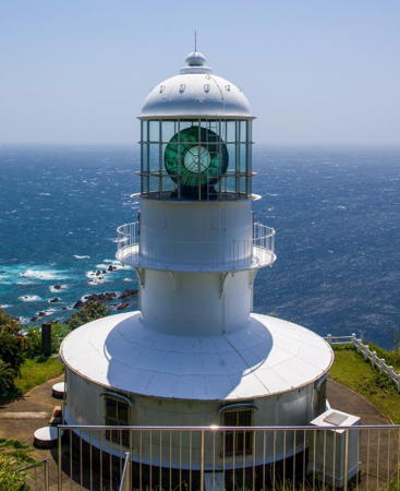
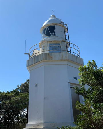
1899. Active; focal plane 155 m (508 ft); white flash every 10 s. 15 m (49 ft) round cylindrical cast iron tower with lantern and gallery, centered on a round 1-story cast iron keeper's house. Entire lighthouse painted white. The original 3rd order clamshell Fresnel lens remains in use, although the lens had to be repaired after being damaged when typhoon winds broke the lantern windows in 1934. A 1-story stone keeper's house is in use as a visitor center and museum. This is Japan's second-oldest cast iron lighthouse. The light, one of Japan's most powerful, has a range of 48 km (30 mi). A 2023 photo is at the top of this page, Lighthouse-Japan.com has a page with excellent photos, FOAL's page has many photos, Lighthouse Visit also has photos, Marta Nimlos has a fine closeup, Trabas has a closeup photo, Misty's Tour has additional photos of the lighthouse in operation, and Google has a street view and a satellite view. Muroto Saki is a sharp-pointed cape at the south end of the Anan Coast and the east entrance to Tosa Bay. The lighthouse guarding this prominent cape is one of Shikoku's best known and most important lights and a great historic treasure. Located on the point of the cape with a 300° panoramic view of the Pacific. Accessible by road and a short hiking trail; the entrance is well marked and parking is available. Site open, tower closed, but there is an observation platform behind the tower and above the level of the lens. . ARLHS JPN-380; JCG-3027; Admiralty M5586; NGA 10084.
Murotomisaki Kō West Breakwater Extension
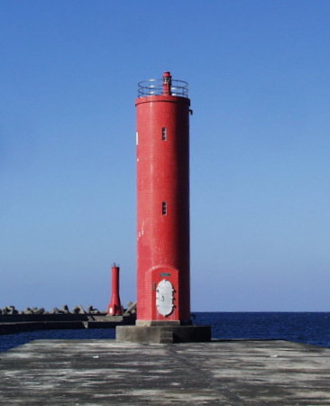
Date unknown. Active (?); focal plane 17 m (56 ft); continuous red light with a brighter flash every 4 s. 13 m (43 ft) round cylindrical concrete tower, painted red. A Coast Guard photo is at right, FOAL's page for the harbor lights has photos (third row and bottom row right), Trabas has a closeup photo, Lighthouse Visit has a photo (first lighthouse on the page), and Google has a satellite view and a distant street view. The Admiralty dropped this light in March 2023 but it remains on FOAL's list of active lights. Located at the end of a spur extending from the "west" (really south) breakwater of Murotomisaki, a port in the lee of Muroto Saki, about 2.5 km (1.5 mi) northwest of the point of the cape. Site and tower closed. ARLHS JPN-2500; JCG-3028; ex-Admiralty M5587.2; NGA 10092.
Murotomisaki Kō Outer Breakwater
Date unknown. Active; focal plane 20 m (66 ft); continuous green light with a brighter flash every 4 s. 16 m (52 ft) round tapered concrete tower, painted red. Trabas has a closeup photo, FOAL's page for the harbor lights has photos (second row left and fourth row right), Lighthouse Visit has a photo (last lighthouse on the page), and Google has a satellite view and a distant street view. Located at the end of the detached outer breakwater of Murotomisaki. Accessible only by boat. Site and tower closed. ARLHS JPN-2498; JCG-3029.5; Admiralty M5587.4; NGA 10098.
Murotomisaki Breakwater Lights
Murotomisaki West Breakwater Extension Light (foreground)
and Outer Breakwater Light, Muroto
Japanese Coast Guard Fifth Region photo (no longer online)
Murotomisaki Kō South Breakwater
Date unknown. Active; focal plane 14 m (46 ft); red flash every 3 s. 16 m (52 ft) round cylindrical concrete tower, painted white. FOAL's page for the harbor lights has photos (second row right and bottom row left), Lighthouse Visit has a photo (second lighthouse on the page), Trabas has a closeup photo, and Google has a satellite view and a distant street view. Located at the end of the south breakwater of Murotomisaki. Site and tower closed. ARLHS JPN-2499; JCG-3029; Admiralty M5587.3; NGA 10096.
#Murotomisaki Kō South Inner Breakwater
Date unknown. Deactivated and demolished in 2012. This was a 14 m (46 ft) round tapered concrete tower, painted white. No photo available. Located at the end of the main inner breakwater of Murotomisaki. Google's satellite view confirms the removal of the lighthouse. Site status unknown. ARLHS JPN-2501; ex-JCG-3030; ex-Admiralty M5587; ex-NGA 10088.
[Tosamurotsu Kō South Breakwater]
Date unknown. Active; focal plane 19 m (62 ft); two red flashes every 6 s. 17 m (56 ft) round tapered concrete tower. Entire lighthouse is red. Trabas has a closeup photo, Lighthouse Visit has photos (top half of the page), and Google has a satellite view. Located at the end of the south (main) breakwater of Muroto, a port in the lee of Muroto Saki, about 5 km (3 mi) northwest of the point of the cape. Accessible only by boat. Site and tower closed. JCG-3031 Admiralty M5589; NGA 10100.
* Tosamurotsu Kō (North Jetty)
Date unknown. Active; focal plane 11 m (36 ft); green light, 3 s on, 3 s off. 8.5 m (28 ft) round hourglass-shaped concrete tower. Entire lighthouse is white. Trabas has a closeup photo, Lighthouse Visit has photos (lower half of the page) and Google has a satellite view. Located at the end of the north inner breakwater of Muroto. Accessible only by boat. Site and tower closed. ARLHS JPN-2497; JCG-3032; Admiralty M5590; NGA 10104.
* Hane Saki
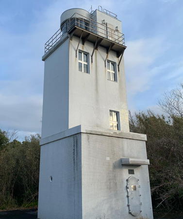
1953. Active; focal plane 78 m (256 ft); two white flashes every 20 s. 11 m (36 ft) rectangular cylindrical concrete tower with lantern and gallery. The lighthouse is unpainted white concrete. Yukihiro Matsumura's photo is at right, Lighthouse-Japan.com has a page with several good photos, FOAL's page has good photos, Misty's Tour has another photo, a 2022 photo is available, Trabas has a distant view, and Google has a satellite view. Located on a promontory about 10 km (6 mi) northwest of Muroto. Accessible by road; the entrance from the coastal road is on the east side of the cape. Some local guidance may be needed, however. Site open, tower closed. . ARLHS JPN-086; JCG-3033; Admiralty M5591; NGA 10108.

Hane Saki Light, Muroto, October 2023
Instagram photo by Yukihiro Matsumura

Nahari Town Lighthouses
* Nahari Kō East Breakwater
Date unknown. Active; focal plane 14 m (46 ft); red flash every 3 s. 10 m (33 ft) concrete post attached to a square 1-story concrete equipment shelter. Entire lighthouse is red. FOAL has a photo (second row left), Lighthouse Visit has a photo (first lighthouse on the page), Trabas has a photo, and Google has a satellite view. Located at the end of the east breakwater of Nahari harbor. Accessible by walking the pier. Site open, tower closed. ARLHS JPN-2504; JCG-3034; Admiralty M5592.2; NGA 10112.
* Nahari Kō West Breakwater
Date unknown. Active; focal plane 12 m (39 ft); green flash every 3 s. 9.5 m (31 ft) round concrete tower, flared at the top. Entire lighthouse is white. Trabas has a photo, FOAL has a photo (bottom row right), Lighthouse Visit has a photo (last lighthouse on the page), and Google has a satellite view. Located at the end of the west breakwater of Nahari harbor. Accessible by walking the pier. Site open, tower closed. ARLHS JPN-2503; JCG-3035; Admiralty M5592.3; NGA 10116.
Nahari Kō Detached Breakwater
Date unknown. Active; focal plane 16 m (52 ft); two red flashes every 6 s. 8.5 m (28 ft) round concrete tower, flared at the top and attached to a small equipment shelter. Entire lighthouse is red. FOAL has a photo (bottom row left), Lighthouse Visit has a photo (second lighthouse on the page), Trabas has a photo, and Google has a satellite view. Located at the west end of a detached breakwater of Nahari harbor. Accessible only by boat. Site open, tower closed. ARLHS JPN-2505; JCG-3034.3; Admiralty M5592.4; NGA 10118.

Yasuda Town Lighthouses
* Tonohama (Karahama)
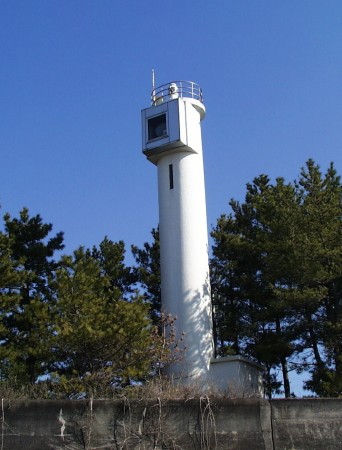
1969. Active; focal plane 24 m (79 ft); continuous white spotlight shown over a narrow arc over nearby shoals. 17 m (56 ft) round concrete tower with a boxlike lantern for the sector light. Entire lighthouse is white. The Coast Guard's photo is at right, Lighthouse Visit has a page for the light, FOAL's page has good photos, Misty's Tour has a photo, Trabas has a photo, and Google has a street view and a satellite view. A main light (JCG-3036), formerly shown from a small gallery at the top of the tower, was discontinued in March 2013. Located on a promontory on the east side of Yasuda and about 8 km (5 mi) southeast of Aki. Accessible by road, but limited parking is available. Site open, tower closed. ARLHS JPN-2518; JCG-3037; Admiralty M5592.5; NGA 10120.
Tonohama
Tonohama Light, Yasuda
Japanese Coast Guard Fifth Region photo (no longer online)
* Yasuda Kō
1982. Active; focal plane 15 m (49 ft); red flash every 5 s. 9.5 m (31 ft) round cylindrical red concrete tower. FOAL's page for the lighthouse has photos, Lighthouse Visit has a page for the light, Trabas has a closeup photo, and Google has a satellite view. Located at the end of the breakwater in Yasuda. Accessible by walking the pier. Site open, tower closed. ARLHS JPN-2523; JCG-3038; Admiralty M5592.55; NGA 10124.

Kōnan City Lighthouse
* Tei Saki
1958. Active; focal plane 29 m (95 ft); white light, 4 s on, 2 s off. 11.5 m (38 ft) round vase-shaped concrete tower with gallery and four ribs mounted on a 1-story equipment room. Entire lighthouse is white. Trabas has an excellent photo, Lighthouse-Japan.com has a page with good photos, FOAL's page has photos, Lighthouse Visit also has a page for the lighthouse, Misty's Tour also has a photo, and Google has a street view and a good satellite view. The ribs are unusual for a Japanese lighthouse. Located on a promontory near the northernmost point of Tosa Bay, about 12 km (7.5 mi) west of Aki. Accessible by road and parking is available nearby. Site open, tower closed. . ARLHS JPN-638; JCG-3041; Admiralty M5593; NGA 10136.

Kōchi City Lighthouses
Kōchi is the capital of the prefecture; its population of about 320,000 is nearly half the population of the prefecture. Urado Bay, the city's harbor, is a small sheltered basin connected to the Pacific by a narrow inlet.
* Kōchi Tanezaki Breakwater
1968. Active; focal plane 12 m (39 ft); red light, 3 s on, 3 s off. 10 m (33 ft) concrete post attached to a square 1-story concrete equipment shelter. Entire lighthouse is red. Trabas has a photo, Lighthouse Visit has photos (lower half of the page), FOAL has photos (fourth and eighth rows, left), a 2021 photo is available, and Google has a distant street view and a satellite view. Located on a short breakwater pier on the north side of the entrance to Kōchi harbor. Accessible by walking the pier. Site open, tower closed. ARLHS JPN-2516; JCG-3046; Admiralty M5594.8; NGA 10160.
Kōchi Entrance
Date unknown. Active; focal plane 16 m (52 ft); green light, 3 s on, 3 s off. 11 m (36 ft) square skeletal tower, painted white. A adjacent square equipment building may be the base of an earlier light. Trabas has a closeup photo, FOAL has two photos (fourth and seventh rows), a view from the harbor is available, and Google has a satellite view and a closeup street view. Located at the end of the breakwater on the west side of the entrance to Kōchi harbor. May be accessible by walking the pier. Site open, tower closed. JCG-3045; Admiralty M5595; NGA 10156.
* Kōchi (Ryuzu Saki) (2)
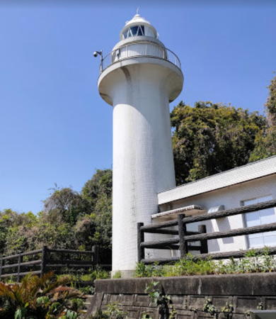
1971 (station established 1883). Active; focal plane 50 m (164 ft); white flash every 5 s. 15.5 m (50 ft) round concrete tower with lantern and gallery, attached to a 1-story service building. Entire lighthouse is white. A photo is at right, Trabas has a fine closeup photo, Lighthouse-Japan.com has a page with good photos, FOAL's page also has photos, Lighthouse Visit also has a page, Misty's Tour has another photo, a 2009 photo is available, Hisatomo Tatsuki has a street view, and Google has a satellite view. We do not know the fate of the original lighthouse. Kōchi is the principal port on the south side of Shikoku, with a large estuary forming its harbor. This lighthouse is located on Ryuzu Saki, a hilly promontory on the southwest side of the harbor entrance. Despite its urban location this lighthouse is not so easy to find; it is hidden from the road by trees and the entrance is cryptically marked. Site open, tower closed. . ARLHS JPN-2493; JCG-3044; Admiralty M5594; NGA 10152.

Susaki City Lighthouses
Usa Kō (East Breakwater)
Date unknown. Active; focal plane 13 m (43 ft); two red flashes every 6 s. 9.5 m (31 ft) round concrete tower with a flared top, attached to a small equipment shelter. Entire lighthouse is red. Trabas has a closeup photo, Lighthouse Visit has a photo (last lighthouse on the page), and Google has a satellite view. Located at the end of the east (main) breakwater of Usa, at the mouth of the Niyodo River. Site status unknown; may be accessible by walking the pier. ARLHS JPN-2521; JCG-3068.5; Admiralty M5596.25; NGA 10190.

Kōchi (Ryuzu Saki) Light, Kōchi, April 2021
Google Maps photo by さんけろ (Sankero)
Usa Kō Training Wall (Detached Breakwater)
Date unknown. Active; focal plane 11 m (36 ft); green flash every 3 s. 9.5 m (31 ft) concrete post attached to a square 1-story concrete equipment room. Entire lighthouse is white. Trabas has a closeup photo, FOAL has a photo (at the bottom of the page), Lighthouse Visit has photos, another photo (#3069, also near the bottom of the page) is available, a 2021 photo is available, and Google has a satellite view. Located at the east end of the detached breakwater of Usa harbor. Accessible only by boat. Site open, tower closed. ARLHS JPN-2522; JCG-3069; Admiralty M5596.2; NGA 10192.
* Shirono (Sirono) Hana
1953. Active; focal plane 57 m (187 ft); white light, 3 s on, 3 s off. 7.5 m (25 ft) square cylindrical concrete tower, rising from one corner of a square 1-story concrete equipment building. Entire lighthouse is white. Lighthouse-Japan.com has a page with photos, FOAL's page has closeup photos, Misty's Tour has two additional photos, Kazutaka Chosokabe has a 2023 closeup, Trabas has a distant view, and Google has an indistinct satellite view. Located at the tip of a peninsula on the south side of the entrance to the Niyodo River estuary, about 8 km (5 mi) southeast of Tosa. Accessible by a hiking trail; a small parking area is provided but the trail is unmarked. Site open, tower closed. ARLHS JPN-583; JCG-3068; Admiralty M5596.3; NGA 10188.
Yamazaki Hana
Date unknown. Active; focal plane 68 m (223 ft); three white flashes every 13 s; in addition, a spotlight (JCG-3073) illuminates a beacon on a nearby shoal. 11 m (36 ft) round concrete post, adjoining a small equipment cabinet. Entire lighthouse is white. Kazutaka Chosokabe has a closeup 2023 photo, Brian Lottino has a remarkable distant photo of the lighthouse in action, Trabas has a view, and Google has an indistinct satellite view. Located on a sharp, steep promontory on the east side of the entrance to Susaki harbor. This site appears to be inaccessible to the public. ARLHS JPN-752; JCG-3072; Admiralty M5596.4; NGA 10196.

Nakatosa Town Lighthouses
* Kure Kō (Tosakure, Hutana Shima)
Date unknown. Active; focal plane 35 m (115 ft); two white flashes every 7 s; in addition, a spotlight (JCG-3076) illuminates a nearby reef. 9.5 m (31 ft) round concrete tower with gallery. Entire lighthouse is white. Lighthouse-Japan.com has a page with a closeup photo, Aya Airy's good drone view is at right, FOAL's page has good photos, Lighthouse Visit has photos (second lighthouse on the page), Misty's Tour has additional photos, Trabas has a photo, and Google has a satellite view. Located atop a huge rock in the entrance to Kure Kō, the harbor associated with the town of Nakatosa, about 7 km (4.5 mi) south of Susaki. The rock is joined to land by a causeway. Site open but difficult to reach; the rock is accessible by walking the causeway, but most visitors don't try climbing to the light. Tower closed. ARLHS JPN-308; JCG-3075; Admiralty M5596.6; NGA 10208.

Kure Kō Light, Nakatosa, May 2019
Google Maps photo by Aya Airy
Ishibae Se (Ishigabae, Ishi Bae, Isshibase)
1953. Active; focal plane 21 m (69 ft); two white flashes every 5 s. 21 m (69 ft) concrete tower, painted black with one red horizontal band. A Coast Guard photo appears at right, Trabas has a photo, and Lighthouse Visit has photos (first lighthouse on the page), but the lighthouse is not shown in Bing's satellite view. Located on a shoal about 6 km (3.5 mi) east of Kure harbor. Accessible only by boat. Site open, tower closed. JCG-3071; Admiralty M5596.5; NGA 10204.
Kaminokae Kō
Date unknown. Active; focal plane 9.5 m (31 ft); green flash every 3 s. 8 m (26 ft) round concrete tower adjoining a square 1-story concrete equipment shelter. Entire lighthouse is white. This light differs from most Japanese pierhead lights in that the tower is not actually attached to the equipment shelter. Trabas has a closeup photo, FOAL's page has photos, Lighthouse Visit also has a page, Kazutaka Chosokabe has a closeup 2023 photo, and Google has a street view and a satellite view. Located on the south breakwater of Kaminokae harbor. Probably accessible by walking the pier. Site open, tower closed. ARLHS JPN-2491; JCG-3077; Admiralty M5597; NGA 10212.

Information available on lost lighthouses:

Notable faux lighthouses:


Ishibae Se Light, Nakatosa
Japanese Coast Guard Kōchi Office photo

Adjoining pages: East: Tokushima | South: Southern Kōchi

Return to the Lighthouse Directory index | Ratings key

Posted April 23, 2007. Checked and revised February 2, 2024. Lighthouses: 30. Site copyright 2024 Russ Rowlett and the University of North Carolina at Chapel Hill.