Lighthouses of Japan: Tokushima

The nation of Japan, known in Japanese as Nihon or Nippon (日本), occupies an archipelago off the east coast of Asia. The four main islands are Hokkaidō in the north, Honshū (the largest), Shikoku in the south, and Kyūshū in the southwest. The country includes thousands of other islands of all sizes; among them the Ryūkyū (Nansei) Islands are a long chain extending to the southwest and including the large island of Okinawa, and the Nanpō Islands are another long chain extending south into the Pacific Ocean. Much of Japan is mountainous but the coastal regions are densely populated and urbanized; the country's population is about 126 million.

Smallest of the Japanese main islands, Shikoku is divided into four prefectures. This page includes lighthouses of Tokushima Prefecture, occupying the eastern end of the island. Tokushima faces mostly east on the Kii Strait, which connects the Seto Inland Sea to the Pacific Ocean. The southernmost part of the prefecture faces the open Pacific Ocean.

In Japanese the word for a lighthouse is tōdai or toudai (灯台). The words saki and misaki are for capes and headlands, hana ("nose") is a promontory, hantō is a peninsula, shima (also spelled sima or jima) is an island, bae is a reef, iwa or shi is a rocky reef, amase or se is a shoal, wan is a bay, nada is a sound or basin, kaikyō is a strait, kawa is a river, and or minato is a harbor.

Lighthouses in Japan are operated and maintained by the Japanese Coast Guard's Maritime Safety Agency. There is at least one Coast Guard Section Office in each prefecture, often two or more. Tokushima Prefecture has a single office at Tokushima city.

ARLHS numbers are from the ARLHS World List of Lights. JCG numbers are the Japanese Coast Guard's light list numbers. Admiralty numbers are from volume M of the Admiralty List of Lights & Fog Signals. U.S. NGA List numbers are from Publication 112.

General Sources
Lighthouses in Japan - Tokushima
This site covers most of the major lighthouses of Japan.
Lighthouse of Japan -Tokushima
Another comprehensive site, in Japanese, with pages for each prefecture.
Form of a Lighthouse - Tokushima
Another site with many photos of Japanese lighthouses; this source is cited below as FOAL.
Lighthouse Visit
Another good source of lighthouse photos.
Online List of Lights - Japan
Photos by various photographers posted by Alexander Trabas.
Misty's Japanese Lighthouse Tour - Tokushima
Photos and a few notes in English for lighthouses in all parts of the country.
Lighthouses in Tokushima Prefecture
Photos by various photographers available from Wikimedia.
Navionics Charts
Navigation chart for Shikoku.

Komatsushima Light
Komatsushima Light, Komatsushima
Japanese Coast Guard Fifth Region photo
Naruto and Kii Strait Lighthouses

Naruto City Lighthouses
Naruto is at the northeastern corner of Shikoku. To the north is Harima Bay, the easternmost basin of the Seto Inland Sea, and to the east is the Kii Strait, which connects the Seto Inland Sea to the Pacific. The city has a population of about 55,000.

*
Awa Kō (Kitadomari)
1996. Active; focal plane 11 m (36 ft); red flash every 4 s. 8.5 m (28 ft) concrete post attached to a square 1-story concrete equipment shelter. Entire lighthouse is red. Trabas has a closeup photo, FOAL's page for the lighthouse has several photos, Lighthouse Visit also has a page for the light, Kazuaki Nakano has a street view, and Google has a satellite view. Located at the end of the main breakwater at Awa, a small boat harbor on Harima Bay about 6 km (3.5 mi) west of the Naruto Strait. Accessible by walking the pier. Site open, tower closed. ARLHS JPN-2536; JCG-3969.1; Admiralty M5551; NGA 7994.
Kameura Kō
Date unknown. Active; focal plane 12 m (39 ft); red flash every 5 s. 10 m (33 ft) concrete light attached to a square 1-story concrete equipment shelter. Entire lighthouse is red. Trabas has a closeup photo, Lighthouse Visit has a page for the light, and Google has a satellite view and a distant street view. Located at the east end of the detached breakwater of Kameura, about 3 km (2 mi) west of the Naruto Strait. Accessible only by boat. Site open, tower closed. ARLHS JPN-2535; JCG-3968; Admiralty M5551.3; NGA 7988.
* Mago Saki (Sonzaki) (2)
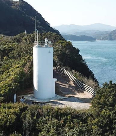
2019 (?) (station established 1951). Active; focal plane 51 m (167 ft); white flash every 5 s. 11 m (36 ft) round cylindrical concrete tower. Entire lighthouse is white. Hiroshi Sakamoto has the drone view at right, Yuuichi Sugimoto has a closeup photo, and Google has a street view and a satellite view. The 1951 lighthouse was a square cylindrical concrete tower with double gallery, attached to a small concrete equipment room. Trabas has a closeup photo of the earlier light, Lighthouse-Japan.com has a page with several 2010 photos, FOAL's page has excellent 2013 photos, Lighthouse Visit has a page, and Misty's Tour has additional photos. This lighthouse marks the south side of the Naruto-Kaikyō (Naruto Strait), which separates Shikoku from the island of Awaji in Hyōgo Prefecture. The strait is very dangerous; its tidal current is the fastest in Japan and fourth-fastest in the world, and whirlpools form regularly. The Ōnaruto Bridge, a link in the Kōbe-Awaji-Naruto Expressway (E28) linking Shikoku and Honshū, crosses the strait just east of the lighthouse. The site commands a broad view of Harima Bay, the easternmost basin of the Inland Sea. Located on the point of the cape; accessible by a short walk from the tourist developments at the south end of the bridge (the entrance is not very well marked). Site open, tower closed. . ARLHS JPN-326; JCG-3455; Admiralty M5551.5; NGA 7168.

Mago Saki Light, Naruto, 2020
Google Maps photo by Hiroshi Sakamoto
Naruto Tobi Shima
Date unknown. Active; focal plane 32 m (105 ft); white flash every 3 s. 22.5 m (74 ft) round cylindrical concrete tower with gallery. Trabas has a photo, Lighthouse-Japan.com has a page with several photos, FOAL has additional photos (near the bottom of the page), Lighthouse Visit also has photos (bottom of the page), Misty's Tour has a view from Mago Saki, and Google has a distant street view from the Ōnaruto Bridge and a satellite view of the lighthouse. This lighthouse is located on a rocky reef in the middle of the Naruto Strait just south of the Ōnaruto Bridge. Accessible only by boat in famously dangerous waters. Site and tower closed. ARLHS JPN-404; JCG-3454; Admiralty M5551.75; NGA 7164.
Naka Se (Nakase)
1946. Active; focal plane 11 m (36 ft); one short and one long red flash every 8 s. 10 m (33 ft) round cylindrical concrete tower, mounted on a round concrete pier. Entire lighthouse is red. A Coast Guard photo is at right, Trabas has a photo, Misty's Tour has a photo, FOAL has additional photos (halfway down the page), Lighthouse Visit also has photos (bottom of the page), and Google has a street view from shore and a satellite view. Located on a rocky shoal in the entrance to Muya harbor. Accessible only by boat. Site and tower closed. JCG-3450; Admiralty M5552; NGA 7148.
Ōiso Saki
1967. Active; focal plane 38 m (125 ft); four white flashes every 15 s. 10.5 m (35 ft) round cylindrical concrete tower with double gallery. In addition, the tower carries a spotlight (JCG-3449) that illuminates a reef 600 m (3/8 mi) offshore. Lighthouse-Japan.com has a page with several photos, Lighthouse Visit also has photos, Trabas has a photo, Misty's Tour has photos, FOAL has additional photos (lower half of the page), and Google has a satellite view. Located on a sharp promontory pointing into the Kii Strait on the east side of Muya. Accessible by a walk along the shore; parking is limited at the entrance to the surrounding park. Site open, tower closed. . ARLHS JPN-455; JCG-3448; Admiralty M5551.8; NGA 7144.

Naka Se Light, Naruto
Japanese Coast Guard Tokushima Office photo (no longer online)

Matsushige Town Lighthouse
* Imagire Kō
1963. Active; focal plane 11 m (36 ft); continuous red light with a more intense flash every 6 s. 9 m (30 ft) round hourglass-shaped concrete tower. Entire lighthouse is red. Trabas has a closeup photo, FOAL has a page for the lighthouse, Lighthouse Visit has a page, and Google has a street view and a satellite view. Located at the end of the north breakwater of Imagire harbor in Matsushige, on the north side of Tokushima. Accessible by walking the pier (a rather long walk). Site open, tower closed. JCG-3445; Admiralty M5554; NGA 7132.

Tokushima City Lighthouses
The prefectural capital of Tokushima is a city of about 260,000 residents located on the Kii Strait at the mouth of the Yoshino River, one of the largest rivers of Shikoku.
Tokushima (Okinosu) North Training Wall East End
1970. Active; focal plane 11 m (36 ft); red flash every 4 s. 9.5 m (31 ft) round cylindrical concrete tower attached to a small entryway. Trabas has a closeup photo, FOAL has another photo (2/3 the way down the page), Lighthouse Visit has a photo (top of the page), and Google has a satellite view. This light appears to be active, although it was dropped from the Admiralty list. Located at the east end of the training wall on the north side of the entrance to Tokushima harbor. Probably accessible only by boat. Site and tower closed. JCG-3437; ex-Admiralty M5556; NGA 7120.
Tokushima (Tuda) Outer Breakwater East Head
Date unknown. Active; focal plane 13 m (43 ft); green flash every 3 s. 9.5 m (31 ft) concrete light attached to a square 1-story concrete equipment shelter. Entire lighthouse is white. A Coast Guard photo is at right, Trabas has a closeup photo, FOAL has another photo (1/3 the way down the page), Lighthouse Visit has a photo (bottom of the page), and Google has a satellite view. Located at the east end of the outer breakwater south of the entrance to Tokushima harbor. Accessible only by boat. Site open, tower closed. JCG-3435; Admiralty M5560; NGA 7112.
Tokushima (Tuda) Outer Breakwater South Head
Date unknown. Active; focal plane 12 m (39 ft); three red flashes every 12 s. 10 m (33 ft) round hourglass-shaped concrete tower. Entire lighthouse is red. Lighthouse Visit has a photo (middle of the page), Trabas has a closeup photo, FOAL has a photo (bottom of the page, on the left), and Google has a satellite view. Located at the south end of the outer breakwater south of the entrance to Tokushima harbor. Accessible only by boat. Site open, tower closed. JCG-3436; Admiralty M5559; NGA 7116.
Okame Iso (Okame Se)
Date unknown. Active; focal plane 17 m (56 ft); two white flashes every 5 s. 17 m (56 ft) concrete post with gallery rising from a round base. Lighthouse painted black with a red horizontal band. Trabas has a photo and FOAL has a photo (1/3 the way down the page, on the right), but the light is not shown in Bing's satellite view. Located on a rock about 5 km (3 mi) southeast of Tokushima harbor and the same distance northeast of Komatsushima harbor. Accessible only by boat. Site open, tower closed. JCG-3420; Admiralty M5555; NGA 7088.
Tokushima Outer Breakwater East Head Light
Outer Breakwater East Head Light, Tokushima
Japanese Coast Guard Tokushima Office photo (no longer online)

Komatsushima City Lighthouses
* Komatsushima
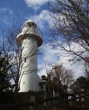
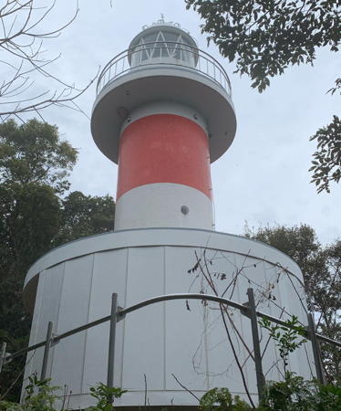
1977. Active; focal plane 92 m (302 ft); white light, 4 s on, 4 s off. 12 m (39 ft) round cylindrical concrete tower with lantern and gallery, attached to a small concrete equipment room. Entire lighthouse is white. The Coast Guard's photo is at the top of this page, Trabas has a photo, Lighthouse-Japan.com has a page with a good photo, FOAL's page for the Komatsushima lights has several good photos, Lighthouse Visit has good photos, a 2022 closeup is available, Misty's Tour has additional photos, and Google has a satellite view. There is also a distant street view from the Komatsushima waterfront. The lighthouse serves as a landfall light for both Tokushima and Komatsushima, two ports separated by a high ridge. Located on the ridge overlooking the harbor of Komatsushima to the south. Accessible by a steep mountain trail, but some local knowledge may be needed; the trail entrance is unmarked at the end of a side street. Site open, tower closed. . ARLHS JPN-283; JCG-3433; Admiralty M5561; NGA 7104.
Taka Sone
Date unknown. Active; focal plane 10 m (33 ft); one short and one long red flash every 8 s. 10 m (33 ft) round concrete tower mounted on a round pier. Entire lighthouse is red. Trabas has a closeup photo, FOAL has two photos (halfway down the page), Lighthouse Visit has a photo (bottom of the page), and Google has a satellite view. Located on a reef about 300 m (330 yd) off a promontory in Komiko, on the south side of Komatsushima. Accessible only by boat. JCG-3434; Admiralty M5562; NGA 7108.
Komatsushima Kō (East Breakwater North End)
Date unknown. Active; focal plane 12 m (39 ft); green flash every 4 s. 13 m (43 ft) round concrete tower with lantern and gallery. Entire lighthouse is white. A Coast Guard photo is at right, Trabas has a good photo, FOAL has another photo (2/3 the way down the page), and Google has a satellite view. Lighthouse-Japan.com has a page with photos of the much smaller South End Light, and the north end lighthouse can be seen in the background. Located at the north end of the detached breakwater protecting the harbor of Komatsushima. Accessible only by boat. Site and tower closed. ARLHS JPN-2538; JCG-3431; Admiralty M5565.4; NGA 7100.
Komatsushima Kō East Breakwater South End
Date unknown. Active; focal plane 9 m (30 ft); red light, 3 s on, 3 s off. 8.5 m (28 ft) round cylindrical concrete tower. Entire lighthouse is red. Trabas has a closeup photo, FOAL has a photo (2/3 the way down the page), Lighthouse-Visit has a photo (halfway down the page), and Google has a satellite view. Located at the south end of the detached breakwater protecting the harbor of Komatsushima. Accessible only by boat. Site and tower closed. ARLHS JPN-2539; JCG-3430; Admiralty M5565; NGA 7096.
Komatsu Breakwater Light
Komatsushima Breakwater North End Light, Komatsushima
Japanese Coast Guard Fifth Region photo
 
* Komatsushima South Breakwater
1953. Active; focal plane 10 m (33 ft); green light, 3 s on, 3 s off. 8.5 m (28 ft) concrete post attached to a square 1-story concrete equipment shelter. Entire lighthouse is white. Trabas has a closeup photo, FOAL's page for the Komatsushima lights has two photos (near the bottom of the page), Lighthouse Visit also has a photo (bottom of the page), and Google has a satellite view. Located at the end of the breakwater; accessible by walking the pier. Site open, tower closed. ARLHS JPN-2540; JCG-3429; Admiralty M5564; NGA 7092.
* [Wadanohana]
2011. Active; focal plane 14 m (46 ft); white light, 3 s on, 3 s off. 9.5 m (31 ft) round cylindrical white fiberglass tower. Trabas has a closeup photo, FOAL has a page for the light, Lighthouse Visit has a photo, Masaaki Katsumata has a 2020 photo, and Google has a street view and a satellite view. Located beside the coastal road on a promontory sheltering the south side of Komatsushima harbor. Site open, tower closed. ARLHS JPN-2552; JCG-3418; Admiralty M5568; NGA 7080.

Anan City Lighthouses
Nakajima (Nakazima) Kō (?)
Date unknown. Active; focal plane 12 m (39 ft); green flash every 3 s. 9.5 m (31 ft) concrete light attached to a square 1-story concrete equipment shelter. Entire lighthouse is white. Trabas has a closeup photo, Lighthouse Visit has a page for the light, a 2021 closeup is available, and Google has a satellite view. Located at the end of the south breakwater of Nakajima harbor, just north of the mouth of the Naka River. Site status unknown. ARLHS JPN-2545; JCG-3417; Admiralty M5571; NGA 7076.
Ao Shima
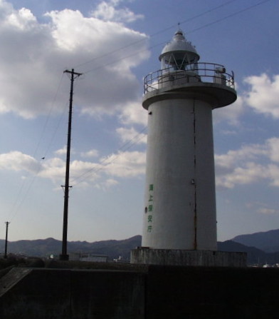
Date unknown. Active; focal plane 58 m (190 ft); two white flashes every 7 s. 12 m (39 ft) round concrete tower attached to a square concrete equipment room. Entire lighthouse is white. The Coast Guard's photo is at right, Trabas has a distant view, FOAL has a distant view (third row, on the right), and Google has a satellite view. Ao Shima is a small island off the entrance to the harbor of Tomioka; it's not known if there is public access to the island. Located on the highest point of the island. Site status unknown. ARLHS JPN-022; JCG-3415; Admiralty M5574; NGA 7068.
Funa Iso
Date unknown. Active; focal plane 17 m (56 ft); two white flashes every 5 s. 14 m (46 ft) round concrete tower with gallery, painted black with a red horizontal band. Trabas has a photo, Lighthouse Visit has a photo, a 2022 closeup is available, and Bing has an indistinct satellite view. Located on a reef off Tachibana harbor. Accessible only by boat. Site open, tower closed. JCG-3414; Admiralty M5575; NGA 7064.
#Tachibana (Tatibana)
Date unknown. Inactive since 2014 and apparently demolished. This was a 10.5 m (35 ft) round hourglass-shaped concrete tower. Entire lighthouse was white. Google's satellite view no longer shows the lighthouse. Fromerly located at the east end of Naga Shima, a steep island that forms a natural breakwater protecting the harbor of Tachibana. Accessible only by boat. Site status unknown. ARLHS JPN-633; ex-JCG-3407; ex-Admiralty M5575.4; ex-NGA 7060.
Ao Shima Light
Ao Shima Light, Anan
Japanese Coast Guard Fifth Region photo
* Karimata Saki
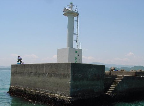
1965. Active; focal plane 22 m (72 ft); white light, 2 s on, 1 s off, 2 s on, 3 s off. 9.5 m round hourglass-shaped concrete tower. Entire lighthouse is white. A Coast Guard photo is at right, Lighthouse-Japan.com has a page with good photos, Trabas has a photo, FOAL's page for the lighthouse has several photos, Lighthouse Visit has a photo, and Google has a closeup street view, but the tower is hard to distinguish in Google's satellite view. Located at the tip of a rocky promontory 3 km (2 mi) northwest of Kamoda Saki. Accessible by a short hiking trail; parking is limited at the trailhead. Site open, tower closed. . ARLHS JPN-233; JCG-3406; Admiralty M5575.6; NGA 7056.
* Kamoda Misaki (2)
1972 (station established 1924). Active; focal plane 48 m (158 ft); white flash every 3 s. 11.5 m (38 ft) round concrete tower with gallery. In addition to the main light, a spotlight (JCG-3404) is shown through a square window to iluminate a nearby and dangerous rock. Entire lighthouse is white. Lighthouse-Japan.com has a page with several photos, FOAL's page has good photos, Trabas has a closeup photo, Lighthouse Visit also has a page, a 2021 photo is available, Jon Elliott has a photo of the pathway to the lighthouse, and Google has a satellite view. Kamoda Misaki (Cape Kamoda) is the easternmost point of Shikoku. The site is accessible by road and parking is provided. Site open, tower closed. . ARLHS JPN-219; JCG-3403; Admiralty M5577; NGA 7052.
Ishima Kō West Breakwater (?)
Date unknown. Active; focal plane 14 m (46 ft); continuous red light with a more intense flash every 3 s. 9.5 m (31 ft) concrete post attached to a square 1-story concrete equipment shelter. Entire lighthouse is red. FOAL has additional photos (bottom of the page), and Google has a satellite view. A height change in March 2019 may signal replacement of this lighthouse. I Shima (Ishima) is an island about 5 km (3 mi) due east of Kamoda Misaki. Located at the elbow of a detached breakwater in the entrance to Ishima harbor. Accessible by boat, although there are good views from ferries arriving at the island. Site open, tower closed. ARLHS JPN-2534; JCG-3402; Admiralty M5576.4; NGA 7048.

Karimata Saki Light, Anan
Japanese Coast Guard Tokushima Office photo (no longer online)
I Shima
1956. Active; focal plane 144 m (472 ft); white flash every 10 s. 22 m (72 ft) square concrete tower with lantern and gallery, rising from a 1-story concrete equipment building. Entire lighthouse is white. Lighthouse-Japan.com has a page with a good photo, FOAL's page for the I Shima lights has photos, Trabas has a distant view, Lighthouse Visit has a distant view, and Google has a satellite view. This important and powerful lighthouse marks the southern entrance to the Kii Strait and Inland Sea. The light has a range of 54 km (33 mi). Located on the highest point of the island of I Shima. Accessible by a hiking trail, but some local guidance will be needed. Site open, tower closed. . ARLHS JPN-153; JCG-3401; Admiralty M5576; NGA 7044.

Pacific Coast Lighthouses

The east coast of Shikoku, from Kamoda Misaki in Tokushima Prefecture to Muroto Saki in Kōchi Prefecture, has a rugged beauty similar to the coast of Oregon. Most of the coast is protected as the Muroto-Anan Kaigan Quasi-National Park, and most of the light stations are in the park.

Minami Town Lighthouses
* Yuki Kō East Breakwater
1961. Active; focal plane 10 m (33 ft); continuous red light with a more intense flash every 3 s. 8.5 m (28 ft) round hourglass-shaped concrete tower. Entire lighthouse is red. Trabas has a closeup photo, FOAL's page for the light has photos, Lighthouse Visit has a photo, and Google has a satellite view and a distant street view across the harbor. Located on the east breakwater of Yuki harbor. Accessible by walking the pier. Site open, tower closed. ARLHS JPN-2554; JCG-3001.5; Admiralty M5577.2; NGA 9988.
* Kiki (Yuki) Kō
1978. Active; focal plane 69 m (226 ft); two continuous white lights. 9 m (30 ft) semicircular tile-covered concrete tower with a hexagonal lantern and a small gallery. Entire lighthouse is white. FOAL's page for the light has photos (lower half of the page), Lighthouse Visit also has photos (lower half of the page), Trabas has a closeup photo, a 2020 photo is available, and Google has a street view and a satellite view. This tower carries two spotlights that illuminate the breakwaters of Kiki harbor, about 2.5 km (1.5 mi) southwest of Yuki harbor and about 2 km (1.2 mi) north of Asebino Hana. Located on a steep hill south of the harbor. Accessible by a twisting mountain road but there's no parking at the light. Site open, tower closed. JCG-3004 and 3004.3; Admiralty M5578.2.
* Asebino Hana
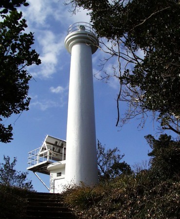
1952. Active; focal plane 160 m (525 ft); white flash every 5 s. 12 m (39 ft) round concrete tower with lantern and gallery. Entire lighthouse is white. Shiyoki Dachiu's 2023 photo is at right, Trabas has a good photo, Lighthouse-Japan.com has a page with several photos, FOAL's page has good photos, Misty's Tour has additional photos, Lighthouse Visit has a good photo, Tomio Tatsumi has a closeup, and Google has a satellite view. Located on a high promontory jutting into the Pacific at the eastern entrance to Hiwasa Bay, about 20 km (13 mi) southwest of Kamoda Misaki. Accessible by a short hiking trail; the entrance is poorly marked. Site open, tower closed. . ARLHS JPN-026; JCG-3005; Admiralty M5578.5; NGA 10000.
* Hiwasa Kō North Breakwater
1966. Active; focal plane 10 m (33 ft); continuous red light with two more intense flashes every 10 s. 8.5 m (28 ft) concrete post attached to a square 1-story concrete equipment shelter. Entire lighthouse is red. Trabas has a closeup photo, FOAL has additional photos, Lighthouse Visit's page has photos, and Google has a street view and a satellite view. Located at the end of the short north breakwater of Hiwasa. Accessible by walking the pier. Site open, tower closed. ARLHS JPN-2532; JCG-3006; Admiralty M5578.8; NGA 10004.


Asebino Hana Light, Minami, November 2023
Instagram photo by Shiyoki Dachiu

#Hiwasa Kō South Breakwater (1)
Date unknown. Replaced. Originally this was an 8.5 m (28 ft) concrete post attached to a square 1-story concrete equipment shelter. Entire lighthouse was white. Sometime between 2010 and 2013 this light was replaced by the smaller beacon (focal plane 13 m (43 ft); green flash every 3 s) seen in Trabas's photo, at the bottom of FOAL's page for the Hiwasa lights and in Google's street view and satellite view. Located at the north end of the detached outer breakwater of Hiwasa. Accessible only by boat. Site open, tower closed. ARLHS JPN-2533. Active light: JCG-3008; Admiralty M5578.6; NGA 10012.

Mugi Town Lighthouses
* Mugi Kō Old Harbor East Breakwater
Date unknown. Active; focal plane about 14 m (46 ft); light characteristic unknown. Approx. 7 m (23 ft) concrete post attached to a square 1-story concrete equipment shelter. Entire lighthouse is red. Trabas has a photo, Lighthouse Visit has a page for the light, and Google has a satellite view and a distant street view. Located on the east breakwater of the port, about 2.5 km (1.5 mi) east of the modern harbor of Mugi. Accessible by walking the pier. Site open, tower closed. JCG-3008.5; Admiralty M5579.4; NGA 10016.
Mugi Kō
1993. Active; focal plane 48 m (157); continuous white spotlight. 7.5 m (25 ft) square cylindrical concrete tower; the light is shown through a square window. Entire lighthouse is white. Trabas has a closeup photo, FOAL's page for the lighthouse has good photos, Lighthouse Visit has photos (bottom of the page), and Google has a satellite view. Located on a promontory on the east side of the entrance to Mugu harbor. Accessible by a footpath but local guidance will be needed. Site open, tower closed. JCG-3013; Admiralty M5580.
* Mugi Kō East Breakwater
Date unknown. Active; focal plane 13 m (43 ft); red light, 3 s on, 3 s off. 11 m (36 ft) round hourglass-shaped red concrete tower. FOAL's page has photos (upper half of the page), Trabas has a photo, Lighthouse Visit has a photo (top of the page), and Google has a satellite view. Located at the end of the east breakwater at Mugi. Accessible by walking the pier. Site open, tower closed. ARLHS JPN-2541; JCG-3011; Admiralty M5579.6; NGA 10024.
* Mugi Kō West Breakwater
1981. Active; focal plane 14 m (46 ft); white light, 3 s on, 3 s off. 9.5 m (31 ft) round concrete post attached to a square 1-story concrete equipment shelter. Entire lighthouse is white. Trabas has a photo, Lighthouse Visit has a photo (middle of the page), FOAL's page has photos (lower half of the page), and Google has a street view and a satellite view. Located at the end of the west breakwater at Mugi. Accessible by walking the pier. Site open, tower closed. ARLHS JPN-2542; JCG-3012; Admiralty M5579.7; NGA 10028.
Deba (Ewa, Teba) Shima
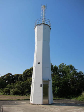
1959. Active; focal plane 87 m (285 ft); two white flashes every 10 s. 11 m (36 ft) octagonal hourglass-shaped concrete tower with gallery, formerly attached to a 1-story concrete equipment building. Entire lighthouse is white. The lighthouse was being rebuilt in January 2010, when the Lighthouse-Japan.com webmaster visited. The photo at right shows that the equipment building was removed and the light was elevated 2 m (6 ft) on a mast atop the tower. Fujisawa Urū has a 2022 photo, FOAL's page for the lighthouse also has 2013 photos, Trabas has a distant view, and Google has a satellite view. Located at the south end of a high island about 6 km (3.5 mi) east of Asakawa harbor. Accessible only by boat. Site open, tower closed. ARLHS JPN-637(=2529); JCG-3009; Admiralty M5581; NGA 10032.

Deba Shima (Tebashima) Light, Mugi, May 2013
ex-Google Plus photo by ごんごん

Kaiyō Town Lighthouses
Shishikui Kō
Date unknown. Active; focal plane 11 m (36 ft); continuous green light with a more intense flash every 5 s. 9.5 m (31 ft) round hourglass-shaped concrete tower. Entire lighthouse is white. Trabas has a closeup photo, Lighthouse Visit's page has a good photo, and Google has a satellite view and a distant street view. Located at the end of the short south breakwater of Shishikui harbor. Site status unknown. ARLHS JPN-2548; JCG-3016; Admiralty M5581.6; NGA 10048.
* Awa Takega Shima
1974. Active; focal plane 97 m (318 ft); white flash every 8 s. 13 m (43 ft) round concrete tower with lantern and gallery, centered on a round 1-story equipment building. Tower painted white with one red horizontal band. Yukihiro Matsumura's 2023 closeup photo is at right, FOAL's page has excellent photos, Lighthouse Visit's page also has good photos, Misty's Tour has additional photos, a 2020 closeup is available, and Google has a satellite view. Takega Shima is an island about 1 km (0.6 mi) long, separated from the mainland of Shikoku by a narrow channel. The island is accessible by bridge. Located at the southeastern tip of the island; accessible by a hiking trail. Site open, tower closed. ARLHS JPN-035; JCG-3017; Admiralty M5581.8; NGA 10052.

Information available on lost lighthouses:

Notable faux lighthouses:


Awa Takega Shima Light, Kaiyō, October 2023
Instagram photo by Yukihiro Matsumura
 

Adjoining pages: North: Awaji Shima | East: Wakayama | South: Northern Kōchi | West: Kagama

Return to the Lighthouse Directory index | Ratings key

Posted April 23, 2007. Checked and revised January 25, 2024. Lighthouses: 36. Site copyright 2024 Russ Rowlett and the University of North Carolina at Chapel Hill.