Lighthouses of Japan: Sakishima Islands

The nation of Japan, known in Japanese as Nihon or Nippon (日本), occupies an archipelago off the east coast of Asia. The four main islands are Hokkaidō in the north, Honshū (the largest), Shikoku in the south, and Kyūshū in the southwest. The country includes thousands of other islands of all sizes; among them the Ryūkyū (Nansei) Islands are a long chain extending to the southwest and including the large island of Okinawa, and the Nanpō Islands are another long chain extending south into the Pacific Ocean. Much of Japan is mountainous but the coastal regions are densely populated and urbanized; the country's population is about 126 million.

Okinawa Prefecture, one of the 47 prefectures of Japan, includes the southern half of the Nansei (or Ryūkyū) Islands (Nansei-shotō or "southwest islands" in Japanese. There are two main groups of islands: the Okinawa Islands, including the principal island of Okinawa itself, and the Sakishima Islands to the southwest. This page includes lighthouses of the Sakishima Islands and there is a separate page for the lighthouses of the Okinawa Islands.

Okinawa was the home of the Ryūkyū Kingdom, established in the early 1400s. In 1609 the islands were conquered by Japan, and thereafter the Ryūkyū Kingdom paid tribute to both Japan and China. Japan annexed the islands in 1879 over Chinese protests; U.S. President Ulysses Grant, called in as arbitrator, ruled in favor of Japan. At the end of World War II in 1945 the Ryūkyū Islands from the Tokara group southward came under U.S. control, at first under a Military Government and then after 1950 under a Civilian Administration. The Okinawa and Sakishima Islands remained under U.S. control until the U.S. ceded sovereignty over all of the Ryūkyūs back to Japan in 1972.

In Japanese the word for a lighthouse is tōdai or toudai (灯台). The words saki and misaki are for capes and headlands, hana ("nose") is a promontory, hantō is a peninsula, shima (also spelled sima or jima) is an island, bae is a reef, iwa or shi is a rocky reef, amase or se is a shoal, wan is a bay, nada is a sound or basin, kaikyō is a strait, kawa is a river, and or minato is a harbor.

Lighthouses in Japan are operated and maintained by the Japanese Coast Guard's Maritime Safety Agency. The Eleventh Coast Guard Region covers Okinawa Prefecture and the Coast Guard Office at Ishigaki is responsible for lights in the Sakishima Islands.

ARLHS numbers are from the ARLHS World List of Lights. JCG numbers are the Japanese Coast Guard's light list numbers. Admiralty numbers are from volume M of the Admiralty List of Lights & Fog Signals. U.S. NGA List numbers are from Publication 112.

General Sources
Lighthouses in Japan - Okinawa
This site has data and photos for nearly all of Japan's major lighthouses.
Lighthouse of Japan - Okinawa
This large and expanding site currently has photos and accounts for lighthouses of the Sakishima Islands.
Lighthouse Visits - 7000-7300
Another excellent source of photos of Japanese lighthouses.
Lighthouses of Okinawa Prefecture
Photos by various photographers available from Wikimedia.
Milestones of the Sea - Miyako and Ishigaki
Posted by the Eleventh Coast Guard Region office, these pages have interactive maps that link to data pages with smaller photos of all the lights in the region.
Online List of Lights - Japan
Photos by various photographers posted by Alexander Trabas. Darlene Chisholm and Jonathon Post (Selector Jonathon Photography) have contributed several photos from Ishigaki.
Navionics Charts
Navigation chart for the islands.


Henna Saki Light, Miyakojima, August 2014
Wikimedia Creative Commons photo
by Paipateroma

Miyako Islands Lighthouses

The Miyako Islands are named for Miyakojima, by far the largest island of the group. The islands have a population of about 55,000. Between the Miyako Islands and the Okinawa Islands is a 250 km (155 mi) wide passage known as the Miyako Strait or Kerama Gap, the widest gap in the Ryūkyū archipelago. This passage is the principal entrance to the East China Sea for international shipping to and from the ports of northern China.

Miyakojima City Lighthouses
Fude (Hude) Iwa
1972. Active; focal plane 16 m (52 ft); white flash every 3 s. 11 m (36 ft) round concrete tower with a flared top. Entire lighthouse is white. Wikimedia has a distant view from the sea and Google has a distant satellite view. Located on an isolated, rocky islet about 15 km (9 mi) northeast of Ikema Shima. Accessible only by boat. Site open, tower closed. JCG-7160; Admiralty M4739; NGA 13500.
* Ikema Shima (3)
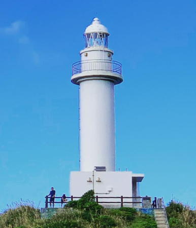
1963 (station established 1940). Active; focal plane 42 m (138 ft); white flash every 12 s. 26 m (85 ft) round cylindrical concrete tower with lantern and gallery. Entire lighthouse is white. A photo is at right, Lighthouse-Japan.com has a page with good photos, the Coast Guard has both a page and an aerial photo, Adachi Takuma has a 2022 photo, T. Hayashi has a 2021 photo, and Google has a street view and a satellite view. This lighthouse is intended as a landfall light for Miyako Shima for vessels arriving from Okinawa or Japan proper. The original lighthouse was destroyed during World War II. It was replaced by a small emergency light in 1950 and then by the present lighthouse in 1963. Ikema Shima is a small island off the northeastern tip of Miyako Shima, connected to the mainland by a 1.6 km (1 mi) long bridge. Located at the northern end of the island. Accessible by road but there's no parking at the lighthouse. A paved sidewalk connects the lighthouse to parking available about 1.2 km (3/4 mi) to the east. Site open, tower closed. . ARLHS JPN-158; JCG-7167; Admiralty M4738; NGA 13504.
**** Henna Saki (Hennazaki, Agari-Henna Saki, Miyako)
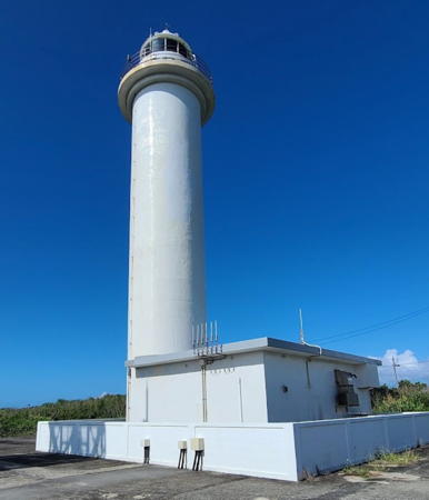
1967. Active; focal plane 43 m (141 ft); flash every 10 s, alternately red and white. 25 m (82 ft) octagonal cylindrical concrete tower with lantern and gallery, attached to a 1-story concrete service building. Entire lighthouse is white. Marton Haesemeyer's photo is at the top of this page, Lighthouse-Japan.com has a page with a portfolio of photos, Wikipedia has a good photo, Nagamu Asakura has a 2021 photo, a more distant view shows the picturesque site, and Google has a closeup street view, a satellite view and a street view from the parking area. The attached building, converted into a lighthouse museum and visitor center, has become one of the principal tourist attractions of Miyakojima. This lighthouse marks the southwestern edge of the Miyako Strait. Located on a sharp promontory at the southeastern tip of Miyako Shima, about 20 km (13 mi) southeast of Hirara. Accessible by road and a walk of about 500 m (0.3 mi) from the parking area. Site open, museum open and tower open for climbing but we do not know the schedule. . ARLHS JPN-105; JCG-7169; Admiralty M4737; NGA 13516.
* [Hirara Kō North Breakwater]
1997. Active; focal plane 12 m (39 ft); two red flashes every 7 s. 7 m (23 ft) fiberglass post surrounded by an octagonal pavilion with benches and a small observation platform. The light tower is red; the pavilion is unpainted gray concrete with a red tile roof. A 2018 closeup photo is available, and Google has a satellite view and a distant street view. Lighthouse-Japan.com has a 2009 photo that shows the pavilion being rebuilt. Located at the end of the west breakwater of Makoto Kō, the harbor of Hirara, the largest town of Miyako Shima, on the west side of the island. Parking is about 600 m (3/8 mi) west of the light, but it's a pleasant walk. Site open, tower closed. JCG-7180.55; Admiralty M4737.52.

Ikema Shima Light, Miyakojima, September 2007
Wikimedia Creative Commons photo
by Paipateroma
Hirara (Taira) Kō
1992. Active; focal plane 8.5 m (28 ft); red flash every 4 s. 8 m (26 ft) concrete post attached to a square 1-story concrete equipment room. Entire lighthouse is red. Lighthouse-Japan.com has a page with photos, Lighthouse Visits has a photo (fourth lighthouse on the page), and Google has a satellite view. Located at the northwest end of a detached breakwater off Hirara. Accessible only by boat. Site open, tower closed. JCG-7180.52; Admiralty M4737.48.
#Sarahama (Ikemasoe) Kō (1)
1989. Replaced in 2020. This was a 9.5 m (31 ft) concrete post centered on a square 1-story concrete equipment shelter. Entire lighthouse is red. Lighthouse-Japan also has a page for the lighthouse, and Google has a satellite view and a distant 2019 street view across the harbor. In 2020 the lighthouse was replaced by a post light (focal plane 14 m (46 ft); two red flashes every 6 s.); Lighthouse Visits has a July 2020 photo. Sarahama is a port at the east end of Irabu Shima, a smaller island just west of Miyako Shima. Located at the south end of the detached main breakwater of Sarahama. Accessible only by boat, but there are good views from ferries arriving from Hirara on Miyako Shima. Site open, tower closed. ARLHS JPN-2619. Active light: JCG-7180.8; Admiralty M4737.7; NGA 13513.

Tarama Village Lighthouses
Miyako Minna Shima
1972. Active; focal plane 22 m (72 ft); white flash every 4 s. 13 m (43 ft) round cylindrical concrete tower mounted on a large concrete base. Entire lighthouse is white. Google has a satellite view. This lighthouse is built on a small island about halfway between Miyako and Ishigaki. Located at the southeastern tip of the island. Accessible only by boat. Site open, tower closed. ARLHS JPN-2611; JCG-7187; Admiralty M4736; NGA 13524.

Yaeyama Islands Lighthouses

Ishigaki City Lighthouses
Ishigaki Shima is an island at the eastern end of the Yaeyama Islands. Organized as a city, Ishigaki has a population of about 50,000 and is readily accessible by air.
Ishigaki Kō (West Outer Breakwater)
1986. Active; focal plane 17 m (56 ft); two green flashes every 8 s. 16 m (52 ft) round cylindrical concrete tower with lantern and gallery. Entire lighthouse is white. Lighthouse-Japan.com has a page with a good photo, Trabas has Chisholm's closeup photo, a 2012 photo is available, Eiki Tsunoda has a 2022 photo, the Coast Guard also has a page for the lighthouse, and Google has a distant satellite view. Located at the northwest end of the detached outer breakwater of Ishigaki, on the southwest side of Ishigaki Shima. Accessible only by boat. Site and tower closed. ARLHS JPN-179(=2601); JCG-7192.5; Admiralty M4734.4; NGA 13548.
Ishigaki Kō (North Breakwater)
1981. Active; focal plane 12 m (39 ft); green flash every 3 s. 9.5 m (31 ft) concrete post attached to a square 1-story concrete equipment shelter. Entire lighthouse is white. Trabas has Chisholm's closeup photo, the Coast Guard also has a page for the lighthouse, and Google has a distant satellite view. Located at the south end of the original north breakwater of Ishigaki. Accessible only by boat. Site and tower closed. ARLHS JPN-2603; JCG-7193; Admiralty M4734.3; NGA 13544.
* Kannon Saki (Ryūkyū Kannon Saki)
1953 (built during the U.S. military administration). Active; focal plane 20 m (66 ft); white light, 3 s on, 3 s off. 11 m (36 ft) square cylindrical concrete tower with gallery, attached to a 2-story concrete equipment building. Entire lighthouse is white. Lighthouse-Japan.com has a page with good photos, Trabas has Post's closeup photo, the Coast Guard also has a page for the lighthouse, a 2023 closeup photo is available, Wikimedia has photos, and Google has a street view and a distant satellite view. Located at the southwestern tip of Ishigaki Shima, about 8 km (5 mi) northwest of Ishigaki city. Accessible by road; parking provided. Site open, tower closed. . ARLHS JPN-515; JCG-7192; Admiralty M4732; NGA 13536.
* Ogan Saki (Ogan Misaki)
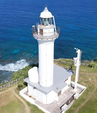
1983. Active; focal plane 62 m (103 ft); white flash every 10 s. 17 m (56 ft) round cylindrical concrete tower with lantern and gallery, rising from a 1-story concrete equipment building. Entire lighthouse is white. Trabas has Post's closeup photo (also seen at right), Lighthouse-Japan.com has a page with good photos, the Coast Guard has a page for the lighthouse, a 2014 photo and a 2021 closeup are available, and Google has a street view and a satellite view. Located at the northwestern tip of Ishigaki Shima. Accessible by road; parking available. Site open, tower closed. . ARLHS JPN-774; JCG-7191; Admiralty M4733; NGA 13532.

Ogan Saki Light, Ishigaki
photo copyright Selector Jonathon Photography; used by permission
* Hirakubo Saki
1972. Active; focal plane 74 m (243 ft); white light, 3 s on, 3 s off. 13 m (43 ft) round cylindrical concrete tower with gallery. Entire lighthouse is white. Lighthouse-Japan.com has a page with good photos, Trabas has Post's closeup photo, a good 2007 photo is available, Daisuke Aoki has a 2020 photo, Wikimedia has a photo, Hiroaki Kanematsu has a 2008 photo, the Coast Guard has a page for the lighthouse, and Google has a street view and a satellite view. This light marks the northern tip of Ishigaki Shima, at the end of 40 km (25 mi) long rocky ridge -- the name of the island means "Stone Wall Island" in Japanese. The site is famous for its spectacular view of the East China Sea. Accessible by road; parking available. Site open, tower closed. . ARLHS JPN-123; JCG-7190; Admiralty M4734; NGA 13528.

Taketomi Town (Iriomote Area) Lighthouses
Taketomi includes the large island of Iriomote and a number of smaller islands. The town has a population of about 2200.
Kuro Shima
1972. Active; focal plane 18 m (59 ft); white flash every 5 s. 11 m (36 ft) concrete post attached to a 1-story concrete equipment room. Entire lighthouse is white. A photo and a closeup photo are available, the Coast Guard has a page for the lighthouse, Lighthouses of Japan has a distant view, and Google has a distant satellite view. Kuro Shima is a small island about 20 km (13 mi) southwest of Ishigaki. The island is included in the Iriomote National Park. Located on the south (seaward) side of the island. Accessible only by boat. Site status unknown. . JCG-7224; Admiralty M4734.6.
* Hatoma Shima (Hatoma-jima)
1972. Active; focal plane 47 m (154 ft); white light, 4 s on, 4 s off. 16 m (52 ft) round cylindrical concrete tower with lantern and gallery. Entire lighthouse is white. A 2021 closeup photo is available, Coast Guard has a page for the light, Lighthouses of Japan has a distant view, Gotō Yōsuke has a closeup street view, and Google has a distant satellite view. Hatoma Shima is a small island about 6 km (3.5 mi) north of the northern tip of Iriomote Shima. Located on the highest point of the island. The island is accessible by ferry from Iriomote Shima. Site open, tower closed. . ARLHS JPN-092; JCG-7238; Admiralty M4730; NGA 13560.
* Hateruma Shima (2)
1986 (station established 1959). Active; focal plane 70 m (230 ft); white light, 3 s on, 3 s off. 16 m (52 ft) round cylindrical concrete tower with lantern and gallery. Entire lighthouse is white. Ryochi Hirata's photo is at right, Makoto Harada has a 2014 closeup, a wider view is available, Lighthouse-Japan.com has a page with good photos, Wikimedia has photos, the Coast Guard has a page for the lighthouse, and Google has a satellite view. This is Japan's southernmost lighthouse. Hateruma Shima is an island about 25 km (15 mi) due south of Iriomote Shima; the island has several popular resorts and permanent population of about 600. NGA misspells the name as "Haterumia." Located at the highest point of the island. Site open, tower closed. . ARLHS JPN-089; JCG-7250; Admiralty M4735; NGA 13568.
Funauki Kō
1969. Active; focal plane 24 m (79 ft); white flash every 6 s. 11 m (36 ft) round cylindrical concrete tower attached to a 1-story equipment building. Entire lighthouse is white. The Coast Guard has a page for the lighthouse, Shingo Sobukawa has a view from the sea, Kaoru Shigehisa has a 2019 view from the sea, and Google has a satellite view. Located on Saba Saki, a promontory on the rugged northwestern coast of Iriomote. Accessible only by boat. Site open, tower closed. ARLHS JPN-2597; JCG-7249; Admiralty M4731; NGA 13564.

Hateruma Shima Light, Taketomi, July 2020
Google Maps photo by Ryochi Hirata

Yonaguni Town Lighthouses
Yonaguni is the westernmost island of Japan, located only 108 km (67 mi) off the east coast of Taiwan. The island has a population of about 1700.
* Agari Saki (Yonaguni Shima, Yonaguni-jima)
1972. Active; focal plane 84 m (276 ft); white flash every 8 s. 10 m (33 ft) round cylindrical concrete tower with double gallery. Entire lighthouse is white. Lighthouse-Japan.com has a page with good photos, the Coast Guard has a page for the lighthouse, Shinsuke Kato has a 2023 photo, Toshimitsu Hayashi has a 2016 closeup, Aori Ika has a street view, and Google has a satellite view. Located on the eastern tip of the island. Site open, tower closed. . ARLHS JPN-003; JCG-7251; Admiralty M4728.4; NGA 13576.
* Iri (Irii) Saki (2)
1980 (station established 1957). Active; focal plane 75 m (246 ft); white flash every 5 s; also a continuous white spotlight illuminates a nearby reef. 20 m (66 ft) round cylindrical concrete tower with lantern and gallery, rising from a 1-story concrete equipment building. Entire lighthouse is white. A photo is at right, the Coast Guard has a page for the lighthouse, Lighthouse-Japan.com has a page with good photos, Kyozuka Madao has a 2022 photo, a closeup photo is available, Yoshinobu Ishiguro has a street view, and Google has a satellite view. This is Japan's westernmost lighthouse. Located at the western tip of Yonaguni Shima. Site open, tower closed. . ARLHS JPN-175; JCG-7252; Admiralty M4728; NGA 13580.
* Kubura Kō
1993. Active; focal plane 17 m (56 ft); green flash every 3 s. 10 m (33 ft) round cylindrical concrete tower with a flared top, attached to a small 1-story concrete equipment shelter. Entire lighthouse is white. Konishi Takashi has a photo, the Coast Guard has a page for the lighthouse, and Google has a satellite view. Located at the end of the breakwater of Kubara, a port just to the north of Iri Saki. Accessible by walking the pier. Site open, tower closed. ARLHS JPN-2626; JCG-7254; Admiralty M4728.3; NGA 13586.

Senkaku Islands Lighthouse

The Senkaku Islands are a small group located in the East China Sea 170 km (110 mi) north of Ishigaki and a similar distance northeast of Taiwan. The islands are the subject of an acrimonious dispute between Japan, China, and Taiwan, with all three countries claiming sovereignty. (China calls the group the Diàoyú Islands and Western navigators formerly called them the Pinnacle Islands.) Japan administers the islands as part of Ishigaki City, but to avoid exacerbating the dispute the central government has prohibited development of the five islands. In September 2012 the government purchased three of the islands from private owners. A chart of the islands is available.
Iri Saki Light
Iri Saki Light, Yonaguni, July 2006
Wikimedia Creative Commons photo by Metatron
Uotsuri Shima (Uotsurijima)
1988. Active; focal plane 17 m (56 ft); white flash every 5 s. 6 m (20 ft) square skeletal tower, painted white. A photo is available and Google has a distant satellite view. The lighthouse was built by the nationalist group Nihonseinensha without permission from the government but in 2005 it was accepted by the Japanese Coast Guard as an official light. Located at the western tip of Uotsuri Shima (known as Diàoyú Dǎo in China), the largest and westernmost island of the group. Site and tower closed. JCG-7300; Admiralty M4727.

Information available on lost lighthouses:

Notable faux lighthouses:

Adjoining pages: Northeast: Okinawa Islands | West: Northeastern Taiwan

Return to the Lighthouse Directory index | Ratings key

Posted August 27, 2007. Checked and revised March 23, 2023. Lighthouses: 20. Site copyright 2023 Russ Rowlett and the University of North Carolina at Chapel Hill.