Lighthouses of Kazakhstan

The Republic of Kazakhstan (Qazaqstan in Kazakh) the ninth largest country of the world, borders Russia to the north and Turkmenistan to the southwest. Known for its wide steppes and high mountains, Kazakhstan is rarely thought of as a maritime nation. However, at its western end Kazakhstan borders the northeastern quadrant of the Caspian Sea. The Caspian is landlocked, but it borders five countries and has a busy international trade.

Kazakhstan was one of the constituent republics of the Soviet Union, becoming independent when the Union collapsed in 1991.

The principal Kazakh ports are Atyrau (formerly Guryev), at the mouth of the Zhayyq (Ural) River near the north end of the Caspian, Aktau (formerly Shevchenko) on the Mangyshlak Peninsula, and a new port under development at Kuryk. Kazahkstan is expanding its ports to strengthen maritime connections with Azerbaijan and Iran, reducing its dependence on Russian routes for its international commerce.

Since 1940 the Kazakh language has been written in the Cyrillic script, but a Latin script similar to that used in Turkish is being phased in from 2023 to 2031. The new Kazakh alphabet lacks the Turkish letters C and Ç but has four additional letters: Ä, Ñ, Q and Ū. The Russian word for a lighthouse, mayak, is commonly used in Kazakhstan, although there is also a Kazakh word bağdarşırak. Mwyis is a cape and aral is an island.

Lighthouses in Kazakhstan are maintained by the Hydrographic Service within the Ministry of Defense. According to GlobalSecurity.org, the Hydrographic Service operates five lighthouses. A December 2014 article from Inform.kz identifies these lighthouses as Mys Peschannyy, Melovoy (Aqtau), Kyzyl-Ozen, and the two Tupkaragan lights. Other lights in the country are maintained by harbor authorities or are assumed to be inactive.

ARLHS numbers are from the ARLHS World List of Lights. Lighthouses on the landlocked Caspian are not included in international light lists.

General Sources
Kazakh Lighthouses
This Russian-language article by Elena Kalinina (no longer online, unfortunately) had valuable information on the history of the historic lighthouses.
List of Lighthouses in Kazakhstan
Partial data compiled by Wikipedia.
World of Lighthouses - Kazakhstan
Photos by various photographers available from Lightphotos.net.
Lighthouses in Kazakhstan
Photos by various photographers available from Wikimedia.
Lighthouses of the USSR - Caspian Sea
Nothing here yet, but hopefully this webmaster will be adding information on the lighthouses.

Tupkaragan Upper Range Rear Light, Bautino, January 2024
Google Maps photo by Ulan Zein
Karakiya District Lighthouses
Fetisovo (Kendirlinskiy)
Date unknown. Inactive; charted as a landmark. 7 m (23 ft) skeletal mast mounted on a square stone pyramid. Two adjoining 1-story buildings. No photo available but Google has a satellite view of the station. Located at the tip of the Kendirlinskiy sand spit enclosing the lagoon of Fetisovo. Site status unknown. ARLHS KAZ-001.
Mys Rakushechnyy
Date unknown. Inactive; charted as a landmark. Approx. 10 m (33 ft) square pyramidal stone tower. Geocaching.su has several photos and Bing has a fuzzy satellite view. Endangered; the tower has a damaged base and could collapse. Located on a prominent cape about 65 km (40 mi) southeast of Yeraliyev. Site open, tower closed. ARLHS KAZ-002.
Eralievo (Yeraliyev, Mys Zhilandy)
Date unknown. Inactive (?); charted as a landmark. Square cylindrical skeletal tower carrying a large slatted daymark. No photo available but Google has a satellite view of the station. Located atop a steep bluff at Mys Zhilandy, a headland about 8 km (5 mi) south of Eralievo (Yeraliyev). Site status unknown. ARLHS KAZ-003.
Ersai Port Range Front
Date unknown. Active; focal plane about 13 m (43 ft); light characteristics unknown. Approx. 10 m (33 ft) square skeletal tower mounted on a square equipment shelter and carrying a large rectangular daymark painted white with a black vertical stripe. A distant view shows both range lights and Google has a satellite view. Ersai is a company that fabricates components for the oil industry. This port serves its Caspian Yard manufacturing facility about 8 km (5 mi) west of the district capital of Quryq (Kuryk). Located on the west breakwater of the port. Site and tower closed. Operator: Ersai.
Ersai Port Range Rear
Date unknown. Active; focal plane about 25 m (82 ft); light characteristics unknown. Approx. 20 m (33 ft) square skeletal tower mounted on a square equipment shelter and carrying a large rectangular daymark painted white with a black vertical stripe. A distant view is at right and Google has a satellite view. Located about 800 m (1/2 mi) northwest of the front light. Site and tower closed. Operator: Ersai.

Ersai Port Range Rear Light, Quryq, August 2021
Google Maps photo by MalcolmQ
Quryq (Kuryk) Rail Ferry Pier
2017. Active; focal plane about 13 m (43 ft); white light, 2 s on, 2 s off. 10 m (33 ft) round white concrete tower. Lightphotos.net has a photo and Google has a satellite view. Quryq is a new port for shipping cargo to ports in Azerbaijan and Iran; in addition crude oil from the Kashagan field is to be shipped across the Caspian to Baku, Azerbaijan, where a pipeline can carry it through Turkey to the Mediterranean. Located at the end of the center pier of the port. Site and tower closed. Operator: Quryq Port.
Quryq (Kuryk) Car Ferry Pier
2017. Active; focal plane about 13 m (43 ft); blue light, 2 s on, 2 s off. 10 m (33 ft) round concrete tower painted with red and white horizontal bands. Lightphotos.net has a photo, Daulet Seiltaev has a view from shore, and Google has a satellite view. Ferries docking at this pier carry mostly trucks rather than cars. Located at the end of the west pier of the port. Site and tower closed. Operator: Quryq Port.
Quryq (Kuryk) Range Front
2017. Active; focal plane about 13 m (43 ft); red light, 2 s on, 2 s off. 10 m (33 ft) square white skeletal tower carrying a large rectangular daymark painted white with a black vertical stripe. Lightphotos.net has a photo and Google has a satellite view. Located at the base of the west breakwater of the port. Site and tower closed. Operator: Quryq Port.
Quryq (Kuryk) Range Rear
2017. Active; focal plane 23.5 m (77 ft); red light, 2 s on, 2 s off. 20 m (66 ft) square white skeletal tower carrying a large rectangular daymark painted white with a black vertical stripe. Lightphotos.net has a distant view and Google has a satellite view.Located 556 m (606 yd) northwest of the front light. Site and tower closed. Operator: Quryq Port.

Munaily District Lighthouses
* Mys Peschannyy
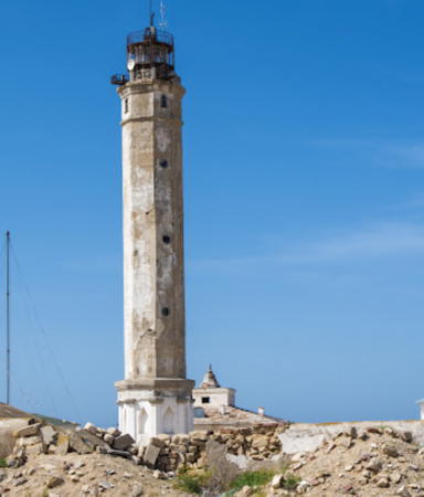
1954. Active; white light, pattern unknown. Approx. 30 m (98 ft) octagonal cylindrical tower with lantern and gallery. The station includes several buildings and a communications tower. A 2024 photo is at right, Ed Nitokshin has a 2012 photo, and Google has a good satellite view. The lighthouse marks Mys Peschannyy (Sandy Cape), a very prominent cape about 40 km (25 mi) south of Aqtau. Located about 1.2 km (3/4 mi) east of the beach and about 4 km (2.5 mi) north of the point of the cape. This area is slated for development of an oil terminal, where oil from Central Asia will be shipped across the Caspian. Site open, tower closed. ARLHS KAZ-004.

Mys Peschanny Light, April 2024
Google Maps photo by Alexey
* Aqtau (Aktau, Shevchenko, Melovoy) (2)
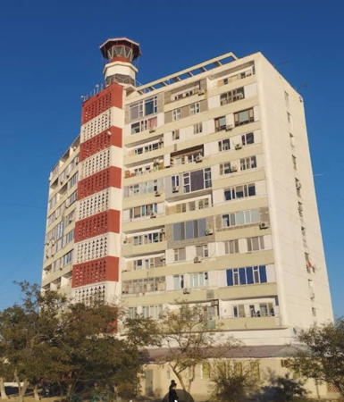
1974 (station established 1948). Active; focal plane 71 m (233 ft); one white flash followed by one red flash every 26 s. 10 m (33 ft) octagonal masonry tower with lantern and gallery centered atop a 12-story apartment building; the total height is 43 m (141 ft). Light tower painted white with one black horizontal band; lantern painted black (formerly red). The front of the building below the light tower is pained in red and white horizontal bands, creating a giant daymark for the light. A 2022 photo is at right, a 2023 photo is available, Anastassiya Lukyanova has a closeup of the light tower, Wikimedia has a good view from the sea, Lightphotos.net has a good photo as well as Eduard Sarkisov's view from the sea, Pedro Loza has a 2007 photo, and the building appears on a Google 2023 street view and satellite view. Lukyanova says that the light has a keeper who lives in a flat on the top floor of the building. Aktau (Aqtaý, formerly called Shevchenko) is Kazakhstan's principal port on the Caspian Sea and the site of former Soviet nuclear and chemical plants. Ferries carry rail traffic across the Caspian between Aktau and Makhachkala on the Russian coast. This is the landfall light for the port. The original light was on a 7.5 m (25 ft) tower close to the water. Located in Aktau on a promontory about 5 km (3 mi) northwest of the ferry port. Site open, tower closed. ARLHS KAZ-005.

Tüpqarağan District Lighthouses
Mys Karamandy
Date unknown. Inactive; charted by Navionics as a daybeacon. Approx. 7.5 m (25 ft) square solid stone tower. Yerzhan Silver has a 2020 photo, Ed Nitokshin has a photo labeled "View from the Lighthouse," and Google has a distant satellite view. Located on a headland about 30 km (19 mi) northwest of Aqtau. Site open.
Maykin Kugran (Mys Sagindik)
Date unknown. Inactive; charted by Navionics as a daybeacon. Approx. 7.5 m (25 ft) square solid stone tower. Elmira Jursalimova has a closeup photo, Dmitry Petrovich has aa 2023 photo, Yerzhan Silver has a street view, and Google has a distant satellite view. Located on a steep promontory about 65 km (40 mi) north of Aqtau. Site open. ARLHS KAZ-007.
Kyzyl-Ozen (Kyzylozen, Shugla) (2?)
Date unknown (station established around 1900). Active (?); charted with a red light. This site includes a 7 m (23 ft) steel post, presumably the original location of the light, and an approx. 20 m (66 ft) square skeletal observation tower. Photos of both towers are available (nearly halfway down the page) and Google has a satellite view. The light was probably moved atop the observation tower but it's not clear whether there is an active light there today. Located about 90 km (55 mi) northeast of Aqtau on the south side of the Tupkaragan Peninsula. Site open, tower closed.


Aktau (Aqtau) Light, Aqtau, October 2022
Google Maps photo by Fourty Seven

Aralda
Date unknown. Inactive; charted as a daybeacon. Approx. 20 m (66 ft) skeletal tower. No photo available but Google has a satellite view. No information has been found about this beacon, although this seems like an appropriate location for a light. Located on a cape about 50 km (30 mi) south of Bautino. Site status unknown.
Tüpqarağan (Tupkaragan, Bautino) Lower Range Front
Date unknown. Active; focal plane about 8 m (26 ft); continuous (?) white light. Approx. 7 m (23 ft) square white concrete tower topped by a short mast. The tower is at the lower left in Levent Sonmez's photo and Google has a satellite view. Located near the waterfront in Bautin (Bautino). Site status unknown.
* Tüpqarağan (Tupkaragan, Bautino) Lower Range Rear
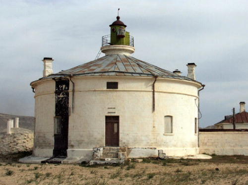
1863. Active; focal plane 16 m (52 ft); continuous red light visible only on and near the range line. Approx. 12 m (39 ft) lantern centered at the peak of a round brick building with a conical metal roof. Building painted white, lantern green. A photo is at right, another closeup photo is available, and Google has a satellite view. Located in downtown Bautino, the port district of Fort Shevchenko. Site open, tower closed. ARLHS KAZ-008.
Tüpqarağan (Tupkaragan) Upper Range Front
Date unknown. Active; focal plane about 15 m (49 ft); white light, pattern unknown. Square white concrete tower, probably similar to the Lower Range Front light (see above). No photo available but Google has a satellite view. This is an approach range. Located about 400 m (1/4 mi) west northwest of the front light. Site status unknown.
* Tüpqarağan (Tupkaragan) Upper Range Rear (2)
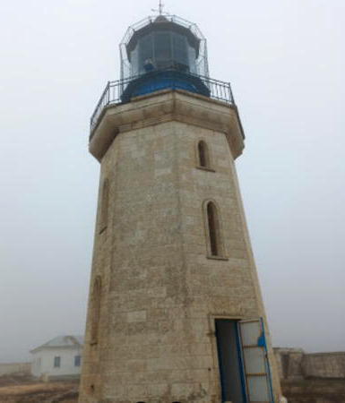
1863 (station established 1851). Active; focal plane unknown; white light, pattern unknown. Approx. 18 m (59 ft) octagonal masonry tower with lantern and gallery, painted white; lantern painted black. Clamshell Fresnel lens in use. Ulan Zein's 2024 photo is at the top of this page, a historic photo of the light in action was posted by SovietMuseum.ru, and the light station can be seen in a Google satellite view. The first lighthouse was built too close to the cliff; it collapsed after a few years. In recent years the lighthouse has been the rear light of a northbound range. This lighthouse is near the westernmost point of Kazakhstan, on the Tupkaragan Peninsula projecting into the northeastern Caspian Sea. Located about 4 km (2.5 mi) south of the northwest point of the peninsula and about 10 km (6 mi) north of Fort Shevchenko. Site status unknown, probably open; tower closed. ARLHS KAZ-009.


Tüpqarağan Lower Range Rear Light
Inform.kz photo

Kulaly Aral (Ostrov Kulaly) (?)
Date unknown. Inactive. No photo available but a Bing satellite view shows the station. Kulaly, the largest and westernmost of the Tyuleniy Islands, is a 25 km (15 mi) long, curving sandbar of an island located about 13 km (8 mi) northwest of the Tupkaragan Peninsula. According to Wikipedia, the island has "a meteorological station with a lighthouse and a Kazakh border guard post." However, the available photos do not reveal a light. Accessible only by boat. Site status unknown.
Zhygylgan (Zhigylganskiy)
Date unknown. Inactive; previously listed with focal plane 170 m (558 ft); white flash every 7 s. 7 m (23 ft) square pyramidal stone tower. Alexander Zazdravnykh has a 2021 photo and Google has an indistinct satellite view. Located on a promontory at Zhygylgan, on the north side of the Tupkaragan Peninsula. Site open, tower closed. ARLHS KAZ-010.

Atyrau City Lighthouses
Atyrau, a city of about 160,000 residents in the delta of the Ural River, is the largest city on the Kazakh Caspian coastline and an important port although large ships cannot navigate the shallow waters at the northern end of the sea..

Ostrov Nordvestinskiy
Date unknown. Active (?); focal plane unknown; white light, pattern unknown. No description available; distant photos appear to show a substantial masonry tower, upper half painted black and lower half white. Paul Reynolds has a very distant view and Bing has an indistinct satellite view. Ostrov Nordvestinskiy is a long sandbar in the northern end of the Caspian Sea, to the east of the entrance channel for Atyrau. Accessible only by boat. Site status unknown.

Information available on lost lighthouses:

Notable faux lighthouses:

Adjoining pages: South: Turkmenistan | West: Russian Caspian Sea

Return to the Lighthouse Directory index | Ratings key

Posted March 12, 2007. Checked and revised August 3, 2024. Lighthouses: 22. Site copyright 2024 Russ Rowlett and the University of North Carolina at Chapel Hill.