Lighthouses of Turkmenistan

Turkmenistan (officially Türkmenistan), a country of west central Asia, borders Iran to the south and Kazakhstan to the north. With a large area and a population of about 6 million it is the most sparsely populated of the central Asian countries. 80% of its area is occupied by the Karakum Desert. However it also has a coastline facing the southeastern quadrant of the Caspian Sea. The Caspian is landlocked, but it has a busy international trade. Turkmenistan was one of the constituent republics of the Soviet Union, becoming independent when the Union collapsed in 1991.

The only Turkmen port of any size is Türkmenbaşy (or Turkmenbashi, known as Krasnovodsk under Russian and Soviet rule). Accessible by air and also by ferry from Bakı (Baku) in Azerbaijan, Türkmenbaşy is the country's main point of contact with Europe.

The entire Caspian coastline is included in Balkan Province, the westernmost of the five provinces into which Turkmenistan is divided.

Since the fall of the Soviet Union the Turkmen language is written in a modified Latin script using an alphabet similar to that of Turkish. The Turkmen word for a lighthouse, maýak, is adopted from Russian. Ada is the word for an island, ýarym ada is a peninsula, burun is a cape, and duralga is a harbor. In Turkmen the Caspian Sea is called Hazar deňzi.

Aids to navigation in the country are presumably maintained by the State Service for Maritime and River Transport.

Former Russian names for the lighthouses are shown in curly brackets {}.

Since lighthouses on the Caspian are not included in international light lists not much is known about them. Further information, especially photos, would be welcome.

ARLHS numbers are from the ARLHS World List of Lights.

General Sources
World of Lighthouses - Turkmenistan
Photos by various photographers available from Lightphotos.net.
Lighthouses of the USSR - Caspian Sea
Nothing here yet, but hopefully this webmaster will be adding information on the lighthouses.
Navionics Charts
Navigation chart for Turkmenistan.

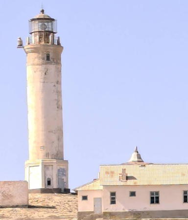
Cheleken Light
Çeleken Light, Hazar, December 2006
ex-Panoramio photo copyright MACTAK; used by permission

Hazar (Çeleken) Area Lighthouses
Hazar is a town of about 30,000 residents located in an oil-producing area south of Türkmenbaşy. The town was formerly called Çeleken in Turkish and Cheleken in Russian.

Ogurja Ada {Ostrov Ogurchinskiy}
1963. Active(?); focal plane about 32 m (105 ft); white light, pattern unknown. 31 m (102 ft) round cylindrical concrete tower with lantern and gallery. Lighthouse painted white, lantern black. Nearby buildings are probably a Turkmen border post. Wikimapia has a very distant aerial view and Google has a satellite view. Ogurja is a 47 km (29 mi) long, sandy island oriented north to south and lying southwest of the Çeleken peninsula. Formerly a pirate hangout and then a leper colony, the island is now an uninhabited nature reserve. The light station is located near the southern tip of the island. Accessible only by boat. Site status unknown. ARLHS TKM-001.
Dervish Ýarymada (Polusostrov Dervish, Dervish Peninsula)
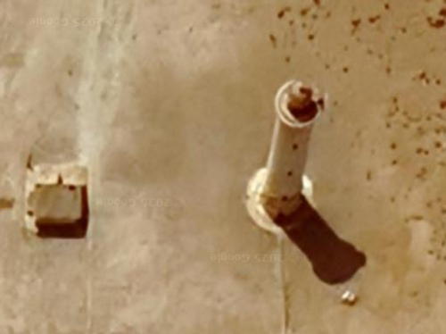
Date unknown. Believed to be inactive. Approx. 10 m (33 ft) brick tower with gallery. No photo available; Wikimapia has a page for the site , describing the lighthouse as abandoned, and Google has a satellite view. Located on the Dervish Peninsula, a sand spit projecting southward from Çeleken, about 25 km (15 mi) south of the Çeleken lighthouse. Site status unknown. ARLHS TKM-002.
Hazar South Breakwater
Date unknown. Active; focal plane about 12 m (39 ft); green light, pattern unknown. Approx. 10 m (33 ft) round concrete tower. No photo available, but Google has an indistinct satellite view. Located at the west end of a detached breakwater protecting the harbor of Hazar (Çeleken). Accessible only by boat. Site status unknown.
Hazar North Breakwater
Date unknown. Active; focal plane about 12 m (39 ft); red light, pattern unknown. Approx. 10 m (33 ft) round concrete tower. No photo available, but Google has an indistinct satellite view. Located at the west end of the north breakwater protecting the harbor of Hazar (Çeleken). Accessible only by boat. Site status unknown.
* Çeleken {Cheleken}
1965. Active; focal plane about 45 m (148 ft); a weak continuous white light is shown. Approx. 40 m (131 ft) round concrete tower with lantern and double gallery. Lighthouse painted white, lantern red. Keeper's house and other light station buildings. A photo is at the top of this page, Wikimapia has several photos, a 2009 photo is available, and Google has a satellite view. Arent van der Veen reported in 2012 that the light is too weak to be useful for navigation. We don't know the height of this lighthouse, but it must be more than 30 m (98 ft). Prior to the 1930s Çeleken was an island; the falling level of the Caspian Sea joined it to the mainland. Located on a prominent cape on the south side of the bay of Kyzyl-Su or Krasnovodsk, about 3 km (2 mi) northwest of the city of Çeleken. Site apparently open, tower closed. ARLHS TKM-003.

Türkmenbaşy (Krasnovodsk) Area Lighthouse
Türkmenbaşy is a city of about 90,000 residents located on the Türkmenbaşy Bay, an inlet of the Caspian Sea. It is Turkmenistan's only international port, linked by ferry to Baki, Azerbaijan, and by rail to the country's capital and points east. The city was founded by Russians as Krasnovodsk in 1869; previously the location had been called Kyzyl-Su ("Red Waters").

Kyzyl-Su (Gyzylsuw) {Bekovicha}
1956. Active(?); focal plane about 30 m (98 ft); white light, pattern unknown. 29 m (95 ft) round or octagonal cylindrical tower with lantern and gallery. A photo is at right and Google has a good satellite view of the station. Türkmenbaşy Bay is partially enclosed by a chain of barrier islands, and the light station is built at one of the highest points in this barrier. The light apparently serves as a landfall light, since it doesn't mark an entrance through the barrier. It replaced a pair of small range lighthouses built in 1908. Accessible only by boat. Site status unknown. ARLHS TKM-004.

Kyzyl-Su Light, Kyzyl-Su
Ashgabad.net (Turkmenistan government) public domain photo
Vufra Burnu
Date unknown. Active; focal plane about 20 m (66 ft); charted by Navionics with a yellow light. No description available but Google has a distant satellite view. Located on the point of Vufra Burnu on the east side of Türkmenbaşy Bay. This is possibly a middle light for the Türkmenbaşy First Reach Range. Site status unknown.
Türkmenbaşy First Reach Range Rear
Date unknown. Active; focal plane unknown; continuous (?) yellow light. Tall skeletal tower apparently carrying a black and white striped daymark. No photo available but Google has a distant satellite view. The range guides vessels through a dredged pass in the Kyzyl-Su barrier and across Türkmenbaşy Bay. The front light is offshore in the bay. Located on the heights of Cape Vufra east of Türkmenbaşy. Site status unknown.
Türkmenbaşy International Seaport Range Front
Date unknown. Active; focal plane unknown; white light, pattern unknown. Tall skeletal tower apparently carrying several daymark panels. No photo available but Google has a satellite view. The range guides vessels into the Türkmenbaşy International Seaport north of Cape Vufra. Located in an industrial area within the port. Site status unknown.
Türkmenbaşy International Seaport Range Rear
Date unknown. Active; focal plane unknown; white light, pattern unknown. Tall skeletal tower apparently carrying several daymark panels. No photo available but Google has a satellite view. Located about 1 km (0.6 mi) northeast of the front light. Site status unknown.
* Türkmenbaşy Range Front
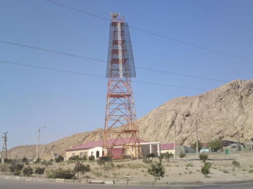
Date unknown. Active; white light, pattern unknown. Approx. 30 m (98 ft) square pyramidal skeletal tower, painted red. The upper portion of the tower carries a trapezoidal slatted daymark painted black with a white vertical stripe. Wikimapia has a photo (also seen at right) and Google has a satellite view. This is the front light of a range guiding vessels into the traditional harbor of Türkmenbaşy. Located across the street from the football stadium in Türkmenbaşy. Site open, tower closed.

Range Front Light, Türkmenbaşy
unattributed Wikimapia photo
* Türkmenbaşy Range Rear
Date unknown. Active; white light, pattern unknown. Approx. 30 m (98 ft) square pyramidal skeletal tower, painted red. The upper portion of the tower carries a trapezoidal slatted daymark painted black with a white vertical stripe. No photo available but Google has a satellite view. Located about 800 m (1/2 mi) northwest of the front light. Site open, tower closed. ARLHS TKM-005.
* Avaza East Breakwater
2010 (?). Active (?); light characteristic unknown. 8 m (26 ft) round white concrete tower with gallery. This is the tower on the right in Andrew Nikitin's photo of the two lighthouses, in a distant view, and in Google's indistinct satellite view. The lights mark the entrance to a small basin, presumably a ferry landing. Located in the Avaza resort development on the Caspian shore about 12 km (7.5 mi) west of Türkmenbaşy. Site open, tower closed. ARLHS TKM-006.
* Avaza West Breakwater
2010 (?). Active (?); light characteristic unknown. 8 m (26 ft) round white concrete tower with gallery. This is the tower on the left in Andrew Nikitin's photo of the two lighthouses, in a distant view, and in Google's indistinct satellite view. Located in the Avaza resort development on the Caspian shore about 12 km (7.5 mi) west of Türkmenbaşy. Site open, tower closed. ARLHS TKM-007.
** Tarta
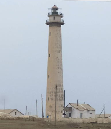
1963. Inactive; charted with a white light. Approx. 17 m (56 ft) hexagonal stone tower with gallery, mounted on a square stone base. The tower was probably painted white originally, but little paint remains. Oleg Storozhenko's photo is at right, Lightphotos.net has Boris Klyavin's 2017 photo, and Google has a satellite view of the lighthouse. Storozhenko reports that the tower was abandoned when he was there in 2007. Located at Tarta Burun, a cape about 5 km (3 mi) northwest of Avaza and 20 km (13 mi) west of Türkmenbaşy. Site open; tower open. ARLHS TKM-011.
#Guvlymayak (Guwly Mayak) {Kuulinskiy} (1)
1897. Inactive since 1953 and demolished by 2017. This was an approx. 40 m (131 ft) square pyramidal cast iron skeletal tower with lantern, gallery, and central cylinder; the central cylinder rises from a square 1-story equipment room. No photo available and the lighthouse has vanished in Google's current satellite view. Guvlymayak means "Swan Lighthouse." Formerly located next to the newer lighthouse (next entry). Site open, tower closed. ARLHS TKM-008.
Tarta Light
Tarta Light, Türkmenbaşy, June 2007
photo copyright Oleg Storozhenko; used by permission
Guvlymayak (Guwly Mayak) {Kuulinskiy} (2)
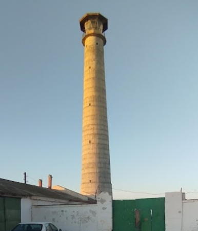
1953 (station established 1897). Active; white light, pattern unknown. Approx. 40 m (131 ft) round concrete tower with lantern and gallery. The 2020 photo at right shows a lighthouse of a typical Soviet design of the 1950s. Bayram Allaberdiyev has a 2021 Facebook photo of this lighthouse "on the shore of Caspian Sea," a 2022 sunset photo is available, and Google has a satellite view. Located on a promontory about 40 km (25 mi) north of Türkmenbaşy. Site open, tower closed. ARLHS TKM-009.

Garabogaz (Bekdaş) Area Lighthouses
The Garabogazköl ("Black Strait Gulf") is a shallow, highly-saline lagoon in the northwestern corner of Turkmenistan. Water from the Caspian tumbles into the lagoon through a very narrow passage through a narrow ridge and mostly evaporates, giving the lagoon a salinity of about 35%, similar to that of the Dead Sea. The town of Garabogaz, called Bekdaş (or Bekdash) until 2002, is at the north end of the ridge.

Karshi {Mys Karasenger}
Date unknown. Probably inactive (appears abandoned); charted with a white light. White concrete tower perhaps 10 m (33 ft) tall. No photo available but Bing has a satellite view. Located on a headland about 30 km (18 mi) south of the Garabogazköl lagoon entrance. Site status unknown.
 

Guvlymayak Light, Guvlymayak, October 2020
Instgram photo by kuli_maya.k
Kara-Ada (Karaada, Bekdaş, Bekdash) {Karaadskiy}
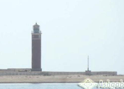
1955. Active(?); focal plane 49 m (161 ft); two white flashes every 13 s. 29 m (95 ft) round cylindrical masonry tower with lantern and gallery. Oleg Guchgeldiyev has the view from the sea seen at right, Lightphotos.net has a photo, Alla Kurbansakhatova has a distant view from shore, and Google has a satellite view of this historic light station. The lighthouse was reported inactive in 2006. Kara Ada is a small island about 2.5 km (1.5 mi) southwest of Bekdaş near the northwestern corner of Turkmenistan. Accessible only by boat. Site status unknown. ARLHS TKM-010.
Bekdaş Range Front
Date unknown. Active; focal plane about 17 m (56 ft); continuous green light. 15 m (49 ft) triangular skeletal tower. Lightphotos.net has a distant view and Google has a satellite view. Located at the end of the main pier at Bekdaş. Site status unknown.
Bekdaş Range Rear
Date unknown. Active; focal plane about 23 m (75 ft); continuous green light. Approx. 20 m (66 ft) square skeletal tower. No photo available but Bing has a satellite view. Located onshore about 250 m (820 ft) northeast of the front light. Site status unknown.

Information available on lost lighthouses:

Notable faux lighthouses:


Kara Ada Light, Bekdaş, June 2005
Google Maps photo by Oleg Guchgeldiyev

Adjoining pages: North: Kazakhstan | West: Northern Iran

Return to the Lighthouse Directory index | Ratings key

Posted April 28, 2008. Checked and revised July 19, 2023. Lighthouses: 21. Site copyright 2023 Russ Rowlett and the University of North Carolina at Chapel Hill.