Lighthouses of Cambodia

The Kingdom of Cambodia (Kampuchea in Khmer) has a rather short coastline facing the Gulf of Thailand between Vietnam and Thailand. Colonized by France as part of French Indochina from 1863 to 1953, Cambodia suffered greatly from the warfare in Vietnam (1955-75) plus the misrule of the Khmer Rouge insurgency (1975-79). However, the country later stabilized and reopened for Western tourism.

During the French colonial period Cambodia had no major salt water ports; it was served by ships sailing the Mekong River through Vietnam. Development of the modern port of Sihanoukville (Kampong Som) on the Gulf of Thailand began only in 1955.

In the Khmer language spoken in Cambodia a lighthouse is called bangkol phleung hvar (បង្គោលភ្លើងហ្វារ, literally "fire on a pole"); koh or kaoh is an island, and kampong phe is a harbor. In Khmer the Gulf of Thailand is called Chhoung Samut Siem (" Gulf of Siam").

The lighthouses in Cambodia are maintained by the Port Autonome de Sihanoukville (PAS).

ARLHS numbers are from the ARLHS World List of Lights. Admiralty numbers are from volume F of the Admiralty List of Lights & Fog Signals. U.S. NGA List numbers are from Publication 112.

General Sources
Online List of Lights - Cambodia
Photos by various photographers posted by Alexander Trabas.
World of Lighthouses - Cambodia
Photos by various photographers available from Lightphotos.net.
Navionics Charts
Navigation chart for Cambodia.


Koh Rung Samloen Light, Sihanoukville, October 2017
ex-Google Plus photo by Lars-Eric Ebert
Preah Sihanouk Province (Gulf of Thailand) Lighthouses
Kaoh Wai (Poulo Wai)
Date unknown. Active (?); focal plane 82 m (269 ft); white light, 2 s on, 2 s off. No description and no photo available but Google has a satellite view that may show the station. The two Wai Islands are located in the Gulf of Thailand about 100 km (60 mi) southwest of Kampong Som. The islands were claimed by Thailand and Vietnam as well as Cambodia. Vietnamese troops occupied the islands briefly in the summer of 1975 but withdrew in favor of Cambodia. Ecotours to the islands are available. Accessible only by boat. Site status unknown. Admiralty F3021; NGA 20496.
Kaoh Rung Samloen
Early 1900s. Apparently inactive but listed with focal plane 120 m (394 ft); two white flashes every 10 s. 18 m (59 ft) round concrete tower with gallery, attached to a small 1-story keeper's cottage or equipment building. Lantern removed. Lars-Eric Ebert's 2017 photo above shows the lighthouse being used as a communications tower and a 2017 street view from the top does not show any light. The lighthouse was originally painted white with one red horizontal band but all the paint has worn off. Dror Miler has a January 2019 photo, a 2023 photo is available, Oli Bryant has a 2010 photo, a 2018 drone view is available, and Google has a satellite view of the station. The Jenkins 1904 light list mentions this light as "intended." The communications gear was added in the summer of 2017; it is not seen in Prum Seng's April 2017 photo. The island of Rung Samloen lies on the west side of the entrance to the bay of Kampong Saom, about 15 km (9 mi) west southwest of Sihanoukville. Located on the south point of the island, about 25 km (15 mi) southwest of Kampong Saom. Site open, and apparently the tower is also open. ARLHS CAB-005; Admiralty F3014; NGA 20532.
Kaoh Koang Kang (Kaoh Tas, Kaoh Kong Kang) (2?)
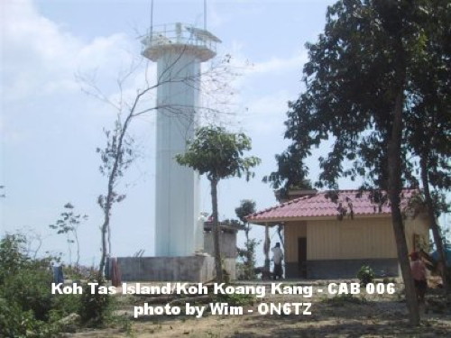
Date unknown. Active; focal plane 14 m (46 ft); white light occulting twice every 9 s. 9 m (30 ft) octagonal cylindrical tower with gallery, painted white. Wim ON6TZ's photo is at right, Dan Baldini has a view from the sea, and Google has a satellite view. NGA lists a skeletal tower for this light. Located at the eastern point of Tas Island, 8 km (5 mi) west of Kampong Saom. Accessible only by boat. Site open, tower closed. ARLHS CAB-006; Admiralty F3015; NGA 20536.
Kaoh Dek Koul (Rocher Dekol)
Date unknown. Active; focal plane 24 m (79 ft); green light, 1.5 s on, 4.5 s off. Listed by NGA as a 9 m (30 ft) skeletal tower, but the only possible location for this light is atop the Buddhist temple that crowns the island. Google has a sea view, a 2023 sea view is available, and an indistinct satellite view. Located on a tiny island off the Kampong Saom waterfront. Accessible only by boat, but passeneger ferry service is available. Site open, tower closed. ARLHS CAB-003; Admiralty F3016; NGA 20540.
Koh Tas Light
Koh Koang Kang (Koh Tas) Light, Sihanoukville
photo copyright Wim ON6TZ/XU7TZG courtesy of
Amateur Radio Lighthouse Society
Kaoh Moul (Kaoh Kon, Îlot Cône)
Date unknown. Active; focal plane 19 m (62 ft); continuous white light. 9 m (30 ft) skeletal tower, according to NGA. No photo available and the light is not seen in Google's satellite view. The forested island of Koh Moul is connected tenuously to the mainland by a sandbar. Located on the north side of the northern entrance to Koh Kong Bay and the port of Krong Khemarak Phoumin (Koh Kong). Site status unknown. Admiralty F3012; NGA 20548.

Siem Reap Province (Tonlé Sap) Lighthouse
Tonlé Sap is a large fresh water seasonal lake. During the dry season it is relatively small and shallow, but during the monsoon (June through October) the Mekong River backs up into the lake, greatly increasing its size. Navigation on the lake is limited to small craft.

Chong Khneas
Date unknown. Active (?); focal plane and light characteristic unknown. Approx. 15 m (49 ft) square skeletal tower with gallery, painted white. The tower carries instruments, probably including an automatic weather station; it appears that a light is shown from a mast. Lightphotos.net has a photo and Google has a distant satellite view. Located about 3.2 km (2 mi) south of Chong Khneas, a boat launching area at the end of highway 63, about 18 km (11 mi) south of Siem Reap. Accessible only by boat. Site open, tower closed.

Information available on lost lighthouses:

Notable faux lighthouses:

Adjoining pages: East: Southern Vietnam | West: Eastern Thailand

Return to the Lighthouse Directory index | Ratings key

Posted August 11, 2007. Checked and revised March 31, 2024. Lighthouses: 6. Site copyright 2024 Russ Rowlett and the University of North Carolina at Chapel Hill.