Lighthouses of Eastern Thailand

Most of the Kingdom of Thailand faces south onto the Gulf of Thailand, an arm of the South China Sea. The country also includes the northern section of the long and narrow Malay Peninsula, which faces both east on the Gulf of Thailand and west on the Andaman Sea, an arm of the Indian Ocean. This page includes lighthouses of the eastern Gulf of Thailand coast; lighthouses of the greater Bangkok area are on the Central Thailand page and lighthouses of the Malay Peninsula are on Southern Thailand: East Coast and Southern Thailand:West Coast pages.

Thailand is unique among southeast Asian nations in having maintained its independence throughout the colonial period. As a result the country's lighthouse history is also independent from all of the European traditions. Many of the country's historic lighthouses were built during or shortly after the reign of King Chulalongkorn (1868-1910), who was successful in modernizing the country while avoiding European penetration.

In the Thai language the word for a lighthouse is prap̣hākhār (ประภาคาร), ko is an island, hin is a rock or reef, laem is a cape, ao is a bay, and maenam is a river.

Coastal lighthouses in Thailand are operated and maintained by the Hydrographic Department of the Royal Thai Navy; lighthouses in the Bangkok area are operated and maintained by the Port Authority of Thailand.

ARLHS numbers are from the ARLHS World List of Lights. THN numbers, where available, are from the Thai Navy's light list. Admiralty numbers are from volume F of the Admiralty List of Lights & Fog Signals. U.S. NGA List numbers are from Publication 112.

General Sources
Leuchttürme in Thailand
Photos taken by Andreas Köhler.
Online List of Lights - Thailand - Gulf of Thailand
Photos by various photographers posted by Alexander Trabas. The photos for Thailand are by Köhler, by Douglas Cameron, or by Rainer Arndt.
Lighthouses in Thailand
Photos by various photographers available from Wikimedia.
World of Lighthouses - Thailand
Photos by various photographers available from Lightphotos.net.
Navionics Charts
Navigation chart of the Thai coast.


Laem Ngop Light, Laem Ngop, January 2020
photo copyright Andreas Köhler; used by permission
Trat Province Lighthouses
Ko Kut (Laem Thian)
Date unknown. Active; focal plane 139 m (456 ft); white flash every 10 s. 30 m (98 ft) square pyramidal skeletal tower, painted white. Panuwat Wundondang has a closeup photo and Google has a satellite view of the station. Ko Kut is a large, mountainous, sparsely populated island in the Gulf of Thailand about 50 km (30 mi) off the southeastern corner of the country. Located at the southern tip of the island. Site status unknown. Admiralty F3010; NGA 20552.
Khlong Yai (2)
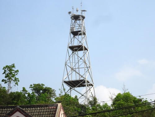
2010(?). Active; focal plane 58 m (190 ft); two white flashes every 5 s. 32 m (105 ft) skeletal tower, painted white. Trabas has Köhler's 2020 photo ( a wider version is at right), Köhler also has a more distant view, and Google has a street view and a satellite view. NGA misspells the name "Khiong Yai." The original tower was similar but its focal plane was only 43 m (141 ft). Located on a hillside behind the waterfront of Khlong Yai, a port in the far southeast of Thailand. Site open, tower closed. ARLHS THA-015; Admiralty F3008; NGA 20556.
Laem Ko Pu Range Front
Date unknown. Active; focal plane 17 m (56 ft); yellow flash every 3 s. 17 m (56 ft) round white tower with lantern and gallery. Trabas has Köhler's 2020 photo and Google has a satellite view. Located in the entrance to the harbor of Laem Ko Pu. Accessible only by boat. Admiralty F3006.5; NGA 20564.5.
Laem Ko Pu Range Rear
Date unknown. Active; focal plane 21 m (69 ft); yellow light, 2 s on, 2 s off. 21 m (69 ft) round white tower with lantern and gallery. Trabas has Köhler's 2020 photo, Google has a distant street view, and Bing has a satellite view. Around 2019 this light was relocated about 110 m (130 yd). Located about 390 m (1/4 mi) north of the front light. Accessible only by boat. Admiralty F3007; NGA 20564.6.

Khlong Yai Light, Khlong Yai, January 2020
photo copyright Andreas Köhler; used by permission
* Laem Ko Pu
Date unknown. Active; focal plane 14 m (46 ft); white flash every 3 s. 12 m (39 ft) triangular concrete skeletal tower. The light tower was formerly painted with red and white horizontal bands but it is all white in a 2018 photo by Khatawut Chaemchamras. Trabas has Köhler's 2020 photo, a 2021 photo is available, and Google has a street view and a satellite view. Located on a marshy point about 15 km (9 m) north of the Laem Nam cape. Accessible by road. Site open, tower closed. Admiralty F3006; NGA 20564.
* Laem Nam (Laem Sok, Cape Sok) (2?)
Date unknown. Active; focal plane 19 m (62 ft); two white flashes every 15 s. 16 m (52 ft) square concrete skeletal tower, painted white (formerly painted with red and white horizontal bands). Trabas has Köhler's 2020 photo (also seen at right), Sitha Opaspimonthum has a street view, and Google has a satellite view and a closeup street view. NGA lists a tripod tower. The lighthouse marks the west side of the entrance to Ao Trat (Trat Bay). Located at the base of the ferry pier on the Laem Nam (or Laem Sok) cape about 25 km (15 mi) south of Trat, in the southeastern corner of Thailand. Accessible by road. Site open, tower closed. ARLHS THA-064; Admiralty F3004; NGA 20560.
Khlong Nam Chiao Range Front
Date unknown. Active; focal plane 13 m (43 ft); yellow flash every 5 s. 10 m (33 ft) tapered round tower, painted white, mounted on a concrete pier. The tower also carries a diamond-shaped slatted daymark, painted white. Trabas has Köhler's 2020 photo, a 2010 photo is available, and Google has a satellite view. This range guides vessels in an estuary east of Laem Ngob. Located in the entrance to the estuary.. Accessible only by boat. Site open, tower closed. Admiralty F3003; NGA 20567.
Khlong Nam Chiao Range Rear
Date unknown. Active; focal plane 16 m (52 ft); yellow light, 2 s on, 2 s off. 13 m (43 ft) tapered round tower, painted white, mounted on a concrete pier. The tower also carries a diamond-shaped slatted daymark, painted white. Trabas has Köhler's 2020 photo, a 2010 photo is available, and Google has a satellite view. Located about 300 m (0.2 mi) northeast of the front light. Accessible only by boat. Site open, tower closed. Admiralty F3003.5; NGA 20567.5.
* Laem Ngop (Laem Ngob) (3?)
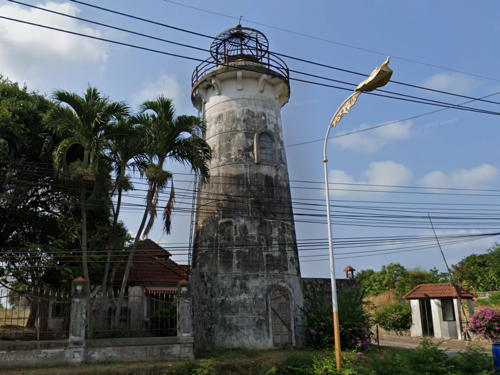
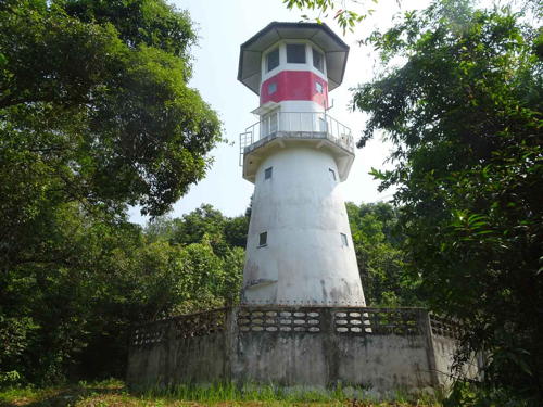
2008 (station established 1911). Active; focal plane 14 m (46 ft); white light, 2 s on, 1 s off. 16 m (52 ft) round concrete tower with lantern and gallery, painted white with two narrow red horizontal bands. Trabas has Köhler's 2020 photo (also seen at the top of this page), Vera Pari has a closeup, another photo is available, and Google has a street view and a satellite view. Laem Ngop is a fishing port and district capital. Located in a roundabout at the base of the pier in Laem Ngop. Site open, tower closed. ARLHS THA-065; Admiralty F3002; NGA 20568.

Laem Nam Light, Laem Nam, January 2020
photo copyright Andreas Köhler; used by permission
Hin Khi Chang
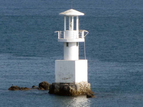
Date unknown. Active; focal plane 14 m (46 ft); three white flashes every 12 s. 11 m (36 ft) square white skeletal tower. Trabas has Köhler's 2020 photo and Google has a distant satellite view. Located on an isolated rock in the center of the strait separating Ko Chang from the mainland west of Laem Ngop. Accessible only by boat. Site open, tower closed. Admiralty F3000; NGA 20572.
Ko Chang (Trat)
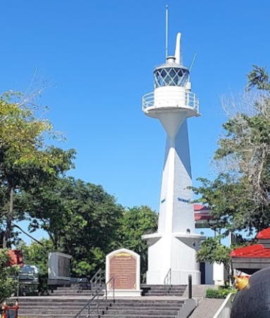
Date unknown. Active; focal plane 91 m (399 ft); three white flashes every 10 s. 17 m (56 ft) round concrete tower with lantern and gallery, painted white with one narrow red horizontal band. Trabas has Köhler's 2020 photo (also seen at right), Alexander Fraser has a similar photo, and Google has a satellite view. Ko Chang, Thailand's third largest island, lies off northern Trat Province and is accessible by ferry from Laem Ngop. Located in dense forest on the western side of the island; accessible by a hiking trail. Site open, tower closed. Admiralty F3001; NGA 20570.

Chanthaburi Province Lighthouses
Ko Chik Nok
Date unknown. Active; focal plane 18 m (59 ft); white flash every 3 s. 8 m (26 ft) "tripod," probably with lantern and gallery. No photo available but Google has a distant satellite view. Ko Chik Nok is an inhabited island in the entrance to the Welu estuary at the southern border of Chanthaburi Province. Accessible only by boat. Site status unknown. Admiralty F2998; NGA 20576.

Ko Chang Light, Trat, January 2020
photo copyright Andreas Köhler; used by permission
Laem Sing
Date unknown. Active; focal plane 83 m (272 ft); white flash every 7 s. 6 m (20 ft) square skeletal tower with lantern and gallery painted white. Thanachard Kanjanachopipat has a 2017 photo (seen at right), Trabas has Köhler's photo, Teeraphong Suthiwaraphirak has a 2019 photo, Suthipong Meechandee has a 2023 photo, Ichsarut Yauvasuta has a closeup street view, and Google has a distant satellite view. Located on a forested headland on the west side of the entrance to Laem Sing. Accessible by a popular hiking trail. Site open, tower closed. ARLHS THA-066; Admiralty F2996; NGA 20580.

Rayong Province Lighthouses
Prasae Range Front
Date unknown. Active; focal plane about 11 m (36 ft); light characteristic unknown. 10 m (33 ft) tapered round tower, painted white, mounted on a concrete pier. The tower also carries a diamond-shaped slatted daymark, painted white. Köhler has a 2020 photo, this light is on the right in a sea view of both range lights, and Google has a distant satellite view. Located about 500 m (0.3 mi) off the end of the east breakwater at Mae Nam Prasae. Accessible only by boat. Not listed by the Admiralty.
* Prasae Range Rear (2?)
Date unknown. Active; focal plane about 22 m (72 ft); light characteristic unknown. 21 m (69 ft) tapered round tower, painted white, mounted on a concrete pier. The tower also carries a diamond-shaped slatted daymark, painted white. Köhler has a 2020 photo, this light is on the left in a sea view of both range lights, a 2018 street view from shore also shows both range lights, and Google has a satellite view. This light was relocated about 350 m (0.22 mi) north around 2016. Located beside the end of the east breakwater at Mae Nam Prasae. Accessible by walking the pier. Not listed by the Admiralty.

Laem Sing Light, Laem Sing, December 2017
Google Maps photo by Thanachard Kanjanachopipat
* Mae Nam Prasae (Prasae River)
Date unknown. Active; focal plane 15 m (49 ft); white flash every 3 s. 16 m (52 ft) triangular skeletal tower. The tower also carries a circular white vertically slatted daymark. Trabas has Köhler's 2020 photo and Google has a street view and a distant satellite view. Located near the waterfront at Noen Kho. Site open, tower closed. Admiralty F2992; NGA 20584.
Ko Man Nok (Ko Mun Nok)
Date unknown. Active; focal plane 47 m (154 ft); white flash every 6 s. 22 m (72 ft) skeletal tower, painted white. Tom Krittapas has a closeup photo and Bing has an indistinct satellite view. Located atop a small, privately owned resort island at the end of a long north-south shoal about 15 km (9 mi) south of Pak Nam Prasae. Accessible only by boat. Site status unknown. Admiralty F2994; NGA 20592.
Ko Samet
Date unknown. Active; focal plane 78 m (256 ft); flash every 5 s, white, red or green depending on direction. 15 m (49 ft) white skeletal tower. In a February 2016 photo the lighthouse was under construction and missing its top. Google has a satellite view. Ko Samet is a popular resort island just off the coast about 30 km (20 mi) southeast of Rayong. Most the island is a national park. Located on heights near the northern end of the island. Site status unknown. THN-115; Admiralty F2990; NGA 20596.
* Rayong (2)
2010(?) (station establishment date unknown). Active; focal plane 15 m (56 ft); three white flashes every 15 s. 16 m (52 ft) round white concrete tower with lantern and gallery. Google's 2022 street view is at right, Okuda Sueji has a 2015 photo, Trabas has Köhler's closeup photo, a 2021 photo is available, and Google has a satellite view. Located on the west side of the harbor entrance at Rayong, a provincial capital east of Sattahip. Site status unknown. ARLHS THA-067; THN-114; Admiralty F2988; NGA 20600.
Map Ta Phut Range Front (2)
Date unknown. Active; focal plane 31 m (102 ft); green flash every 4 s. 30 m (98 ft) robust steel post, painted white with two red bands near the top and carrying a diamond-shaped daymark painted red with a white vertical stripe. Trabas has Köhler's 2020 photo and Google has a satellite view. The original light was on a square or triangular cylindrical skeletal tower. Map Ta Phut is a large petrochemical industrial park with an artificial harbor about 16 km (10 mi) west of Rayong. Located near the waterfront of Map Ta Phut harbor. Site and tower closed. Admiralty F2986.1; NGA 20601.

Rayong Light, Rayong, January 2022
Google Maps street view
Map Ta Phut Range Rear (2)
Date unknown. Active; focal plane 51 m (167 ft); flash every 4 s, white, red or green depending on direction. 30 m (98 ft) robust steel post, painted white with two red bands near the top and carrying a diamond-shaped daymark painted red with a white vertical stripe. Trabas has Köhler's 2020 photo and Google has closeup street view and a satellite view. The original light was on a square or triangular skeletal tower. Located 1.6 km (1 mi) north northwest of the front light. Site and tower closed. Admiralty F2986.11; NGA 20601.1.
* Ban Chang
Early 1900s? Inactive since about 1990. Approx. 12 m (39 ft) round white concrete tower with lantern and gallery. Google's street view is at right, a photo is available and Google has a satellite view. We need information on the history and status of this lighthouse. Located on Nam Rin Road about halfway between Rayong and Phla (Phala) Beach. Site open, tower closed. Owner/site manager: unknown.

Chonburi Province: Sattahip District Lighthouses
Sattahip is a city of about 160,000 residents on a peninsula at the southeastern entrance to the Bay of Bangkok. The city is the home port of the Royal Thai Navy.

Ko Chuang (Ko Chang, Phahurat)
1898. Active; focal plane 144 m (472 ft); two white flashes every 20 s; also a continuous red light, shown over a nearby shoal. 22 m (72 ft) brick tower with lantern and gallery. WiJarn SingCum has a distant view and Google has a satellite view. Located on an island about 25 km (15 mi) south of Sattahip. ARLHS THA-018; THN-113; Admiralty F2982; NGA 20612.
 

Ban Chang Light, Rayong, March 2023
Google Maps street view
 
Ko Chorakhe (Chorake, Ko Nang Ram)
Date unknown. Active; focal plane 58 m (190 ft); two white flashes every 10 s. 5 m (17 ft) (?) round white concrete (?) tower. No photo available but Google has a satellite view. NGA describes this light as a "white round metal pipe"; since the light is set among trees a taller height seems more likely. Located atop a small island about 2 km (1.25 mi) south southeast of the entrance to Sattahip. Accessible only by boat. Site status unknown. ARLHS THA-017; Admiralty F2973.5; NGA 20616.
Hin Chula (2)
Date unknown. Active; focal plane 10 m (33 ft); white flash every 3 s. 10 m (33 ft) round concrete tower with lantern and gallery, mounted on a square concrete base. Entire lighthouse is white. Trabas has Köhler's photo (also seen at right), Suchart Chantrawong has a 2010 photo, and Google has an indistinct satellite view. This lighthouse replaced a round tower painted with black and white bands (as still described by NGA); a photo of that lighthouse is available. Located on a rocky reef off the point of Laem Samaesan, a cape about 15 km (9 mi) southeast of Sattahip, marking a narrow channel between the cape and neighboring islands. Accessible only by boat. Site status unknown. ARLHS THA-008; Admiralty F2976; NGA 20608.
Sattahip Ko Mu Breakwater (2)
Date unknown. Active; focal plane 14 m (46 ft); two white flashes every 5 s. 7 m (23 ft) square cylindrical white concrete tower. Trabas has Köhler's photo, a closeup is available, and Google has a satellite view. A 2010 photo shows a very different tower. Located at the end of a breakwater extending southeast from Ko Mu, an island in the entrance to Sattahip harbor. Accessible only by boat. Site status unknown. Admiralty F2975.4; NGA 20620.

Hin Chula Light, Samaesan, November 2015
photo copyright Andreas Köhler; used by permission
* Sattahip Range Front
Date unknown. Active; focal plane 21 m (69 ft); quick-flashing yellow light. 17 m (56 ft) triangular skeletal tower, painted white; the tower carries a daymark painted red with a white vertical stripe. KaewKarn Manomaya has a 2021 photo, Phuwadol Srimongkol has a 2022 photo, Damrong Naris's 2023 view shows both range lights near the right edge, and Google has a satellite view. This light was moved 50 m (164 ft) north in 2019; a photo and a second photo (tower at the right edge) show the original location at the edge of the wharf. Located at the south end of the Chuksamed Pier at Sattahip. Site open, tower closed. Admiralty F2975; NGA 20628.
Sattahip Range Rear
Date unknown. Active; focal plane 29 m (95 ft); yellow light, 2 s on, 2 s off. 26 m (85 ft) triangular skeletal tower, painted white; the tower carries a daymark painted red with a white vertical stripe. Wasin Sinchai has a photo and Google has a satellite view. Located near the Chuksamed Pier of the naval pier at Sattahip. Site and tower closed. Admiralty F2975.1; NGA 20632.
[Sattahip Ko Tao Mo Breakwater]
Date unknown. Active; focal plane 11 m (36 ft); two white flashes every 6 s. 6 m (20 ft) concrete post with gallery. Entire lighthouse is white. A photo is available and Google has a satellite view. Located at the end of the breakwater extending from Tao Mo Island, at the west entrance to Sattahip harbor. Site status unknown. Admiralty F2974; NGA 20634.
Laem Pu Chau (Laem Pu Cho, Chumphon Khet Udomsak) (2)
Date unknown. Active; focal plane 168 m (551 ft); three white flashes every 15 s. 15 m (49 ft) triangular concrete tower with lantern and gallery. A 2022 photo is at right, Chanyut Chimdee also has a photo, another photo is available, and Google has a street view and a satellite view. The original light was a triangular steel pylon with a lantern attached to one side. Located on a promontory at Sattahip, the site of Thailand's main naval base. Site and tower closed; the light is on the naval base. ARLHS THA-049; THN-110; Admiralty F2973; NGA 20640.
Hin Khi Sua
Date unknown. Active; focal plane 7 m (23 ft); white flash every 5 s. 7 m (23 ft) round tower with gallery, painted black with a red horizontal band. A photo (halfway down the page) and a second photo are available and Google has a satellite view. Located on a rocky reef about 5 km (3 mi) northeast of the Laem Pu Chau lighthouse. Accessible only by boat. Site open, tower closed. ARLHS THA-009; Admiralty F2970; NGA 20644.
Hin Rang Kwian (Ko Rang Kwian)
Date unknown. Active; focal plane 15 m (49 ft); white flash every 3 s. 7 m (23 ft) triangular white concrete skeletal tower, lower half enclosed. A photo and a second photo are available and there's a more distant view but Google has only a fuzzy satellite view of the reef. Located on a rock about 20 km (13 mi) north of Sattahip. Accessible only by boat. Site open, tower closed. Admiralty F2968; NGA 20648.

Laem Pu Chao Light, Sattahip, August 2022
Google Maps photo by AmyLoveMaToom


Information available on lost lighthouses:

Notable faux lighthouses:

Adjoining pages: East: Cambodia | West: Central Thailand

Return to the Lighthouse Directory index | Ratings key

Posted February 28, 2006. Checked and revised April 7, 2024. Lighthouses: 35. Site copyright 2024 Russ Rowlett and the University of North Carolina at Chapel Hill.