Lighthouses of South Korea: Sokcho Area (Northern Gangwon)

For most of its history Korea was an independent kingdom, or at least an autonomous kingdom under Chinese influence. This came to an end in 1910 when Japan annexed all of Korea. At the end of World War II in 1945 the 38° parallel was established as the dividing line between U.S. and Soviet zones of occupation, and in 1948 separate civil administrations were established in the two halves of the country. The Korean War (1950-53) ended in a draw with the armistice line falling close to the prewar 38° line. The Republic of Korea (ROK), commonly called South Korea (Daehan Minguk in Korean), occupies the Korean peninsula south of the armistice line.

South Korea is divided into nine provinces and eight province-level cities. This page covers lighthouses of the northern part of South Korea's east coast in the province of Gangwon (Gangwon-do), including Goseong County (Goseong-gun) and the city of Sokcho (Sokcho-si). This coast faces the East Sea (commonly called the Sea of Japan in the West). Most of it is rugged and scenic but there are some sandy beaches between the headlands.

Navigational aids in the ROK are regulated by the Ministry of Oceans and Fisheries (MOF). Management of lighthouses in Gangwon is the responsibility of the Donghae Regional Office of Oceans and Fisheries, with branch offices in the ports of Mukho, Sokcho, and Samcheok. The Korean Hydrographic and Oceanographic Administration (KHOA) publishes notices to mariners.

In 2000 South Korea adopted a Revised Romanization System to replace systems formerly used in the West. In the Revised System, the word for a lighthouse is deungdae (등대); dan (formerly tan) is a cape, seom (som) or do (to) is an island, am or amseog is a rock, man is a bay, and hang is a harbor. Some place names may be more familiar to Westerners in the spellings of older systems.

The name Korea, used internationally, is a Western version of Goryeo or Koryŏ (고려), the name of a kingdom that unified the country in the tenth century. From 1392 to 1897 the kingdom was known instead as Joseon or Chosŏn (조선). Today South Koreans usually call their country Hanguk (한국, literally "one country") and the official name of the Republic of Korea is Daehan Minguk (대한민국).

ARLHS numbers are from the ARLHS World List of Lights. KR numbers, where available, are from the Korean light list. Admiralty numbers are from volume M of the Admiralty List of Lights & Fog Signals. U.S. NGA List numbers are from Publication 112.

General Sources
Donghae Regional Office - Navigation Aids Office
Information on four major lighthouses of Gangwon Province.
Online List of Lights - Korea
Photos by various photographers posted by Alexander Trabas.
Navionics Charts
Navigation chart for Korea.


Daejin Light, Daejin, October 2020
Google Maps photo by Jo Hakuzan

Goseong County Lighthouses

Before the Korean War Goseong County was entirely in North Korea. The armistice line split the county, so North Korea continues to have a county of the same name on the other side of the Demilitarized Zone.

Hyeonnae Township Lighthouses
* Geojin (Jeojin) Border Range Front
Date unknown. Active; focal plane 29 m (95 ft); continuous green light. 24 m (79 ft) round metal tower painted white. No photo available but Google has a satellite view. This range and the next one mark the edges of a maritime exclusion zone adjoining the Demilitarized Zone between the two Koreas. Located across the street from the office of the border control agency. Site open, tower closed. KR-1202.1; Admiralty M 4460.2.
Geojin (Jeojin) Border Range Rear
Date unknown. Active; focal plane 48 m (157 ft); continuous green light. 39 m (128 ft) round metal tower painted white. No photo available but Google has a satellite view. Located 605 m (3/8 mi) due west of the front light. Site status unknown.KR-1202.2; Admiralty M 4460.21.
* Geojin (Jeojin, Chojin) Dan Range Front
1991(?). Active; focal plane 62 m (203 ft); continuous white light. 35 m (115 ft) square concrete skeletal tower with lantern and gallery. Lighthouse painted white, lantern and gallery red. Fog horn (4 blasts every 60 s). A Coast Guard photo is at right and Google has a satellite view. This range and the previous one mark the edges of a maritime exclusion zone adjoining the Demilitarized Zone between the two Koreas. Geojin Dan is a cape about 8 km (5 mi) south of the armistice line. Located on the cape, accessible by road; parking provided. Site open, tower closed. ARLHS SKR-004; Admiralty M4460; NGA 16365.
Geojin (Jeojin, Chojin) Dan Range Rear
1991(?). Active; focal plane 115 m (377 ft); continuous white light. 20 m (66 ft) square concrete skeletal tower with lantern and gallery. Lighthouse painted white, lantern and gallery red. The tower is in the distance in the photo at right and Google has a satellite view. Located about 1 km (0.6 mi) due west of the front light. Site status unknown. ARLHS SKR-005; Admiralty M4460.1; NGA 16365.1.

Geojin Dan Range Lights
Korean Coast Guard photo
* Daejin (Taejin) (2)
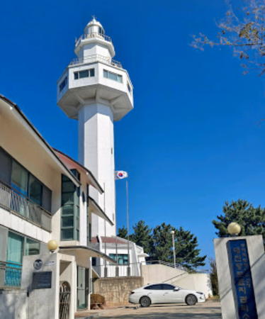
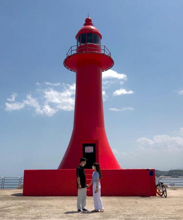
1993 (station established 1973). Active; focal plane 61 m (200 ft); white flash every 12 s. 31 m (102 ft) octagonal white concrete tower with lantern, gallery, and an observation room surrounding the tower about 2/3 of the way up, rising from the center of a 1-story octagonal administration building. Jo Hakuzan's photo is at the top of this page, a similar 2020 photo and a closeup are available, Kim Jin-Woo has a closeup 2016 photo, and Google has a street view and a satellite view. Located on heights above the base of the north breakwater of Daejin harbor. Site open, tower closed. . ARLHS SKR-037; KR-1203; Admiralty M4459.9; NGA 16369.
* Daejin North Breakwater (2)
2010 (station establishment date unknown). Active; focal plane 16 m (52 ft); red flash every 5 s. 10 m (33 ft) vase-shaped concrete tower, painted red. Kim Suyeong has the 2020 closeup photo seen at right, several photos (halfway down the page) are available, Yongho Row has a 2022 view, Kim Cheonjin has a distant view, and Google has a street view and a satellite view. The original lighthouse was apparently removed in 2007-08, probably due to storm damage. Located at the end of the north breakwater of Daejin. Accessible by walking the pier. Site open, tower closed. KR-1206; Admiralty M4459.75; NGA 16374.
* Daejin South Breakwater (2)
Date unknown. Active; focal plane 14 m (46 ft); green flash every 5 s. 11 m (36 ft) round cylindrical concrete tower, painted white. Google has a street view and a satellite view. NGA formerly listed a square steel tower on the breakwater. Located at the end of the north breakwater of Daejin. Accessible by walking the pier. Site open, tower closed. KR-1205; Admiralty M4459.7; NGA 16376.
* Chodo Hang Breakwater (2)
2018(?). Active; focal plane 14 m (46 ft); red flash every 4 s. 12 m (39 ft) round cylindrical red concrete tower with lantern and gallery. Jang Byung-tae has a 2018 photo, 2021 photo is available and Google has a satellite view. The original light, seen in a 2014 street view, was a red skeletal tower. Located on the breakwater of Chodo village, about 1.6 km (1 mi) south of Daejin. Accessible by walking the pier. Site open, tower closed. KR-1206.5; Admiralty M4459.65; NGA 16387.

Daejin North Breakwater Light, Daejin, September 2020
Google Maps photo by Kim Suyeong

Geojin Town Lighthouses
#Geojin-ri (Kojin-ni) (1)
1965. Inactive since 2008. 12 m (39 ft) round concrete tower with lantern and gallery, painted white. A photo is available. This lighthouse was replaced and apparently it has been demolished. Located on a promontory about 5 km (3 mi) south of Daejin. Site open, tower closed.
* Geojin-ri (Kojin-ni) (2)
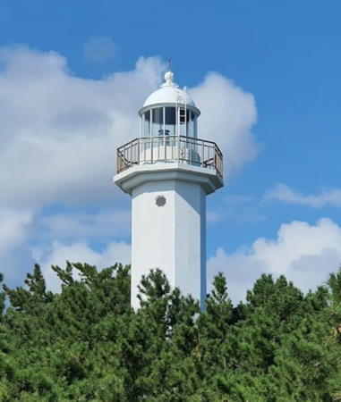
2008 (station established 1965). Active; focal plane 90 m (295 ft); flash every 16 s, alternately red and white. 13 m (42 ft) round concrete tower with lantern and gallery, painted white. Lee Sang-hoon has a 2019 closeup (also seen at right), another good photo is available, and Google has a street view and a satellite view. The area surrounding the lighthouse is a park, the Geojin Lighthouse Sports Park. Located on a promontory about 5 km (3 mi) south of Daejin. Site open, tower closed. . ARLHS SKR-013; KR-1207; Admiralty M4459.5; NGA 16388.
Geojin-ri East Breakwater (2)
Date unknown. Active; focal plane 16 m (52 ft); red flash every 4 s. 8.5 m (28 ft) octagonal cylindrical concrete tower with gallery, painted red. A 2019 photo and another photo are available, a third photo shows both breakwater lights, and Google has a satellite view and a street view from the beach. Located at the end of the east breakwater of Geojin-ri. Site status unknown. KR-1208; Admiralty M4459.6; NGA 16392.
* Geojin-ri West Breakwater
Date unknown. Active; focal plane 11 m (36 ft); green flash every 5 s. 10 m (33 ft) round hourglass-shaped concrete tower, painted white. A 2022 photo and another photo (second photo on the page) are available, a second photo shows both breakwater lights, and Google has a satellite view and a closeup street view. Located at the end of the west breakwater of Geojin-ri. Accessible by walking the pier. Site open, tower closed. KR-1209; Admiralty M4459.54; NGA 16396.
* Banam Hang
2021. Active; focal plane 14 m (46 ft); red flash every 6 s. 9 m (30 ft) round red concrete tower. An August 2021 photo of the new lighthouse is available but it is not yet seen in Google's fuzzy satellite view of the port. Located on the breakwater of a small harbor about 2.5 km (1.5 mi) south of Geojin harbor. Site open, tower closed. KR-1209.2; Admiralty M4459.47.

Geojin-ri Light, Geojin, May 2019
Google Maps photo by Lee Sang-hoon

Jugwang Township Lighthouses
* Gajin (Kajin) Hang East Breakwater
Date unknown. Active; focal plane 16 m (52 ft); red flash every 5 s. 10 m (33 ft) round cylindrical concrete tower painted red. Lee Chun Woo has a 2019 photo of both lights and Google has a satellite view. Located on the end of the east breakwater at Gajin. Accessible by walking the pier. Site open, tower closed. KR-1209.5; Admiralty M4459.45; NGA 16376.5.
* Gajin (Kajin) Hang West Breakwater (2)
Date unknown. Active; focal plane 16 m (52 ft); green flash every 5 s. 10 m (33 ft) round cylindrical concrete tower, painted white. Lee Chun Woo has a 2019 photo of both lights and Google has a street view and a satellite view. Located on the end of the west breakwater at Gonghyeonjin. Accessible by walking the pier. Site open, tower closed. KR-1209.8; Admiralty M4459.46.
* Gonghyeonjin Hang East Breakwater (2)
Date unknown. Active; focal plane 14 m (46 ft); red flash every 4 s. 10 m (33 ft) round cylindrical concrete tower, painted red. Kei Unggaro has a street view of both lights, Kwang Lee has a street view from the south breakwater, and Google has a satellite view. The previous light, described as a "red post,"was only 6 m (20 ft) in height. Located on the end of the east breakwater at Gonghyeonjin. Accessible by walking the pier. Site open, tower closed. KR-1209.3; Admiralty M4459.43; NGA 16377.
Gonghyeonjin Hang West Breakwater (2)
Date unknown. Active; focal plane 14 m (46 ft); green flash every 4 s. 10 m (33 ft) round cylindrical concrete tower, painted white. Kei Unggaro has a street view of both lights, Kwang Lee has a closeup street view, and Google has a satellite view. Located on the end of the west breakwater at Gonghyeonjin. Accessible by walking the pier. Site open, tower closed. KR-1209.4; Admiralty M4459.44.

Northern Toseong Township Lighthouses
Oho Ri (2?)
Date unknown. Active; focal plane 27 m (89 ft); white flash every 5 s. 10 m (33 ft) (?) octagonal white concrete tower, probably with lantern and gallery. Kim Hyung-dong's photo is at right, Kim So-Ra has a 2018 view across the harbor, and Google has a satellite view and a street view through trees. NGA lists a 10 m (33 ft) round tower; the present tower appears to be taller. Located atop a promontory sheltering Oho-ri harbor. Site status unknown. Admiralty M4459.3; NGA 16378.
Oho Hang East Breakwater
Date unknown. Active; focal plane 13 m (43 ft); red flash every 5 s. 10 m (33 ft) round cylindrical concrete tower, painted red. Doo Won Lee has a 2021 photo and Google has a satellite view and a distant street view. Located on the end of the east breakwater at Oho-ri. Site status unknown. KR-1211; Admiralty M4459.4; NGA 16379.
Oho Hang West Breakwater (2)
2021 (?). Active; focal plane 12 m (39 ft); green light, pattern unknown. 10 m (33 ft) round cylindrical concrete tower, painted white. Jaeryong Choi has a 2021 photo. Google's satellite view shows the earlier skeletal tower. Located on the end of the west breakwater at Oho-ri. Site status unknown. Admiralty M4459.405.

Jugwang Township Lighthouses
Munam Hang North Breakwater
Date unknown. Active; focal plane 12 m (39 ft); red flash every 4 s. 10 m (33 ft) round cylindrical concrete tower, painted red. Na Sang-cheol's photo shows both breakwater lights and Google has a street view and a satellite view. Located at the end of the north (main) breakwater of Munam harbor, about 25 km (15 mi) southeast of Daejin. Site status unknown. KR-1212; Admiralty M4459.2; NGA 16386.
Munam Hang West Breakwater
Date unknown. Active; focal plane 12 m (39 ft); green flash every 4 s. 10 m (33 ft) round cylindrical concrete tower, painted white. Na Sang-cheol's photo shows both breakwater lights and Google has a street view and a satellite view. Located at the end of the west breakwater of Munam harbor, about 25 km (15 mi) southeast of Daejin. Site status unknown. KR-1212.1; Admiralty M4459.22.
Munam Hang South
2020 (?). Active; focal plane 8 m (26); green flash every 6 s. 5 m (16.5 ft) bulbous round concrete white tower. A 2021 photo is available and Google has a satellite view. A 2014 street view shows no light here. Located on a pier on the south side of Munam harbor. Site status unknown. KR-1212.8; Admiralty M4459.26.

Oho Ri Light, Gonghyeonjin, October 2020
Google Maps photo by Kim Hyung-dong
Gyoam Hang North Breakwater
Date unknown. Active; focal plane about 14 m (46 ft); red light, pattern unknown. 10 m (33 ft) octagonal cylindrical red concrete tower. J.O. Hur has a photo showing both breakwater lights, Yoon-Jeong Lee has a 2021 photo of both lights, and Google has a satellite view. Located on the north (main) breakwater at Gyoam, about 3 km (2 mi) south of Oho. Site status unknown. Admiralty M4459.281.
Gyoam Hang South Breakwater
Date unknown. Active; focal plane about 14 m (46 ft); green light, pattern unknown. 10 m (33 ft) octagonal cylindrical white concrete tower. J.O. Hur has a photo showing both breakwater lights, Yoon-Jeong Lee has a 2021 photo of both lights, and Google has a satellite view. Located on the short south breakwater at Gyoam. Site status unknown. Admiralty M4459.282.
Gyoam Hang South (2)
Date unknown. Active; focal plane about 12 m (39 ft); yellow light, pattern unknown. Approx. 12 m (39 ft) round yellow concrete tower with gallery. Yaekyum Lee has a 2020 photo and Google has a satellite view. A 2014 street view shows a skeletal tower. Located off the beach at Munamjin. Accessible only boat. Site open, tower closed. Admiralty M4459.28.
 

Southern Toseong Township Lighthouses
Ayajin Northeast Shoal
Date unknown. Active; focal plane 13 m (43 ft); three quick white flashes every 10 s. 16 m (52 ft) round cylindrical concrete tower, painted black with one yellow horizontal band. Google has a very distant street view from shore and a distant satellite view. Located on a shoal about 2 km (1.25 mi) northeast of Ayajin. Accessible only by boat. Site open, tower closed. KR-1214; Admiralty M4459.18.
* Ayajin (Ayajin-ni)
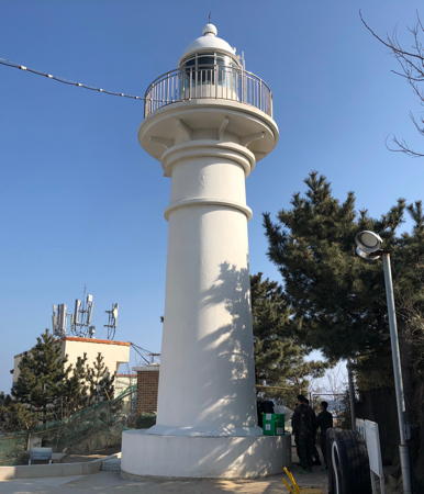
1958. Active; focal plane 23 m (75 ft); white flash every 6 s. 15 m (49 ft) round concrete tower with lantern and gallery. Entire lighthouse is white. An MOF photo is at right, a view from the waterfront is available and Google has a street view and a satellite view. Located on a hillside above the foot of the north breakwater at Ayajin. Site open, tower closed. ARLHS SKR-030; KR-1213; Admiralty M4459; NGA 16380.
* Ayajin North Breakwater (2)
Date unknown. Active; focal plane 17 m (56 ft); red flash every 5 s. 10 m (33 ft) round concrete tower with eight fins, like a rocket. Entire lighthouse is red. Hye Sook Kim has a closeup photo, a 2023 closeup is available, J.K. Youngman has a photo, and Google has a street view and a satellite view. Photos of the original breakwater lighthouses are also available. Located on the north (main) breakwater at Ayajin, about 8 km (5 mi) north of Sokcho. Accessible by walking the pier. Site open, tower closed. . ARLHS SKR-031; KR-1215.1; Admiralty M4459.16; NGA 16384.
* Ayajin South Breakwater (2)
Date unknown. Active; focal plane 13 m (43 ft); green flash every 5 s. 10 m (33 ft) round concrete tower with eight fins, like a rocket. Entire lighthouse is white. A closeup, a 2022 closeup, and another photo (fifth photo on the page) are available and Google has a street view and a satellite view. Located on the south breakwater at Ayajin. Accessible by walking the pier. Site open, tower closed. ARLHS SKR-032; Admiralty M4459.15; NGA 16385.
* Bongpo (Pongpo) North Breakwater (2)
Date unknown. Active; focal plane 15 m (49 ft); red flash every 5 s. 10 m (33 ft) round concrete tower with lantern and gallery. Entire lighthouse is red. Yeonju Im has 2023 photo. Jeonjae Jeon has a closeup photo of the earlier light, another closeup is available, and Google has a street view and a satellite view. Located on the north (main) breakwater at Bongpo, about 4 km (2.5 mi) north of Sokcho. Accessible by walking the pier. Site open, tower closed. KR-1215.5; Admiralty M4458.7; NGA 16376.7.

Ayajin Light, Ayajin
Donghae Oceans and Fisheries photo

Sokcho City Lighthouses

Sokcho is a city of about 90,000 residents. It is about 25 km (15 mi) north of latitude 38°, so prior to the Korean War the city was in North Korea. An ususual feature of the city is that it has two brackish lakes, Yeongrangho and Cheongchoho, each connected to the sea by narrow channels.

Jangsa Ward Lighthouses
Sajin (Jangsa) Hang Groin
Date unknown. Active; focal plane 12 m (39 ft); green flash every 5 s. 10 m (33 ft) round cylindrical concrete tower painted white. DongWoon Yoo has a distant 2022 view and Google has a 2018 street view and a satellite view. The north breakwater is marked by a red skeletal tower. Located on the south breakwater at Sajin-ri, a fishing harbor at the entrance to the Yeongrangho lake on the north side of Sokcho. Accessible by walking the pier. Site open, tower closed. KR-1215.9; Admiralty M4458.64; NGA 16397.
Yeongnangho South Breakwater
Date unknown. Active; focal plane 12 m (39 ft); four yellow flashes every 8 s. 10 m (33 ft) round cylindrical concrete tower painted white. Google has a street view and a satellite view. Located on a breakwater immediately to the south of the Jangsa breakwaters. Accessible by walking the pier. Site open, tower closed. KR-1215.12; Admiralty M4458.61.

Sokcho Harbor Lighthouses
*** Sokcho (2)
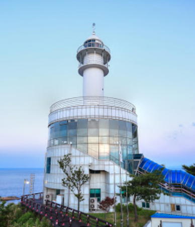
2006 (station established 1957). Active; focal plane 48 m (157 ft); four white flashes every 45 s. 10 m (33 ft) round cylindrical concrete tower rising from a circular 1-story building; a round museum building has been wrapped around the lower half of the tower, and there is an observation deck atop the museum. Entire lighthouse is white. Fog horn (one 5 s blast every 45 s). Jaewoo Park's photo is at right, a view from the harbor is available, J. Riu has a 2021 closeup, and Google has a street view and a satellite view. A closeup photo of the original lighthouse is available. Apparently the new lighthouse was built during 2005 (there are several references to the light being closed that year). The light station includes a popular museum of navigational aids. Located atop a steep hill just north of the harbor of Sokcho. Limited parking is available in the beachfront commercial area. Site open, museum and observation deck open daily. . ARLHS SKR-025; Admiralty M4458; NGA 16404.
Sokcho East
Date unknown. Active; focal plane 16 m (52 ft); quick-flashing white light. 20 m (66 ft) square cylindrical tower with a round equipment structure at the top. Lower half of the tower painted yellow, upper half black. A photo shows this light and the north breakwater light (next entry), BoBae Jung has a distant street view from the shore and Google has a satellite view. Located about 800 m (1/2 mi) east northeast of the north breakwater lighthouse (next entry). Accessible only by boat. Site open, tower closed. KR-1218.5; Admiralty M4458.1; NGA 16406.

Sokcho Light and Observatory, Sokcho, June 2021
Google Maps photo by Jaewoo Park
* Sokcho North Breakwater (2)
2009 (station establishment date unknown). Active; focal plane 18 m (59 ft); red flash every 4 s. 11 m (36 ft) tapered round concrete tower with lantern and gallery, painted red. Je Xun's photo is at right, Brian Wolff has a closeup street view, another photo also shows the Sokcho East light, and Google has a satellite view. There's also a photo of the original light. Located at the end of the north (outer) breakwater of Sokcho. Probably accessible by walking the pier. Site open, tower closed. . KR-1217.8; Admiralty M4458.3; NGA 16408.
Sokcho Passenger Pier North
2020. Active; focal plane 8.5 m (28 ft); green flash every 4 s. 6 m (20 ft) round white steel tower. No photo available but Google has a satellite view. Located on the northeast corner of the cruise ship terminal in Sokcho harbor. Site and tower closed. KR-1218.3; Admiralty M4458.601.
Sokcho Passenger Pier South
2020. Active; focal plane 8 m (26 ft); green flash every 4 s. 6 m (20 ft) round white steel tower. No photo available but Google has a satellite view. NGA lists a similar light on the earlier pier at this location (ex-Admiralty M4458.6; NGA 16412). Located on the southeast corner of the cruise ship terminal in Sokcho harbor. Site and tower closed. KR-1218.2; Admiralty M4458.5.
* #Sokcho Sinsuro (South) Breakwater Middle
Date unknown. Active; focal plane 11 m (36 ft); green flash every 4 s. This was an 8 m (26 ft) round cylindrical white concrete tower; it has been replaced by a post light centered in Google's street view and satellite view. This is apparently the original south breakwater, now an inner breakwater of the harbor. Probably accessible by walking the pier. Site open, tower closed. Active light: KR-1220; Admiralty M4458.4; NGA 16409.5.
* Sokcho Sinsuro (South) Breakwater Head
Date unknown. Active; focal plane 18 m (59 ft); green flash every 4 s. 11 m (36 ft) tapered round concrete tower with lantern and gallery, painted white. H.J. Hys has a 2022 photo, a 2023 photo is available, Tae-Il Yoon has a closeup (but truncated) street view, and Google has a satellite view and a very distant street view. Located at the end of the south breakwater of Sokcho. Probably accessible by walking the pier. Site open, tower closed. KR-1220.7; Admiralty M4458.35.
 

Sokcho North Breakwater Light, Sokcho, May 2021
Instagram photo by Je Xun
Jodo (Cho Do)
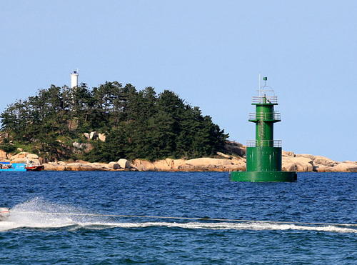
Date unknown. Active; focal plane 36 m (118 ft); white flash every 6 s. 15 m (49 ft) round cylindrical white concrete tower. Man Joong Kim has a photo, Jinho Jung has the distant view seen below right, and Google has a satellite view. Located atop a small island just southeast of the entrance to Sokcho harbor. Accessible only by boat. Site status unknown. KR-1219; Admiralty M4458.2; NGA 16414.
Jodo Approach West
Date unknown. Active; focal plane 14 m (46 ft); two green flashes every 10 s. 14 m (46 ft) round 2-stage concrete tower, painted green. The listed tower height of 25 m (82 ft) is clearly too high. Jinho Jung has the photo seen at right, Seop Yoon has a distant view, Shokiriy Janoplari has a street view from shore, and Google has a satellite view. Located about 500 m (0.3 mi) southeast of Jodo. Accessible only by boat. Site open, tower closed. KR-1220.5; Admiralty M4458.18; NGA 16418.
Jodo Approach East
Date unknown. Active; focal plane 16 m (52 ft); six quick white flashes followed by one long white flash, every 45s. 22 m (72 ft) beacon mounted on a square platform supported by four large piles. Lower half of the lighthouse painted black, upper half yellow. The light is on the right in Man Joong Kim's photo and Google has a satellite view. Located about 1 km (0.6 mi) east of the Jodo lighthouse. Accessible only by boat. Site open, tower closed. Admiralty M4458.15; NGA 16416.

Daepo Ward Lighthouses
* Daepo (Taep'o) Hang East Breakwater (2)
2009. Active; focal plane 18 m (59 ft); red flash every 5 s. 10 m (33 ft) round concrete tower with four ribs, lantern and gallery, painted red. A 2020 photo and a 2016 street view are available, Jeon Jongho has a closeup photo, and Google has a satellite view. The Daepo harbor was expanded considerably in 2008-09 and both breakwaters are new. Located on the east (main) breakwater at Daepo harbor, on the south side of Sokcho. Accessible by walking the pier. Site open, tower closed. KR-1221.10; Admiralty M4457.2.

Jodo Light (left) and Jodo Approach West Light, Sokcho, August 2008
ex-Flickr Creative Commons photo by Jinho Jung
* Daepo (Taep'o) Hang West Breakwater
2009. Active; focal plane 18 m (59 ft); green flash every 5 s. 10 m (33 ft) round concrete tower with four ribs, lantern and gallery, painted white. Nama Kim has a view from the east breakwater and Google has a street view and a satellite view. Located on the west breakwater at Daepo harbor. Accessible by walking the pier. Site open, tower closed. KR-1221.11; Admiralty M4457.3.
* Seorak Hang
2011. Active; focal plane 17 m (56 ft); red flash every 4 s. 10 m (33 ft) octagonal cylindrical concrete tower, painted red. A monument attached to the tower portrays a Korean ski jumper, as seen in closeup 2020 street view. Jun Lee also has a street view and Google has a satellite view. Located on the main breakwater at Seorak harbor, a short distance south of the Daepo harbor. Accessible by walking the pier. Site open, tower closed. KR-1221.12; Admiralty M4457; NGA 16420.

Information available on lost lighthouses:

Notable faux lighthouses:

Adjoining pages: North: North Korea | South: Gangneung Area

Return to the Lighthouse Directory index | Ratings key

Posted October 29, 2007. Checked and revised September 29, 2023. Lighthouses: 46. Site copyright 2023 Russ Rowlett and the University of North Carolina at Chapel Hill.