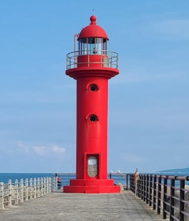
Lighthouses of South Korea: Gangneung Area (Central Gangwon)

For many centuries Korea was an independent kingdom or at least an autonomous kingdom under Chinese influence. This came to an end in 1910 when Japan annexed all of Korea. At the end of World War II in 1945 the 38° parallel was established as the dividing line between U.S. and Soviet zones of occupation, and in 1948 separate civil administrations were established in the two halves of the country. The Korean War (1950-53) ended in a draw with the armistice line falling close to the prewar 38° line. The Republic of Korea (ROK), commonly called South Korea, occupies the Korean peninsula south of the armistice line.

South Korea is divided into nine provinces and eight province-level cities. This page covers lighthouses of the northern part of South Korea's east coast in the province of Gangwon (Gangwon-do), including Yangyang County and the county-level city of Gangneung. This coast faces the East Sea (commonly called the Sea of Japan in the West). Most of it is rugged and scenic, but there are some sandy beaches between the headlands.

Navigational aids in the ROK are regulated by the Ministry of Oceans and Fisheries (MOF). Management of lighthouses in Gangwon is the responsibility of the Donghae Regional Office of Oceans and Fisheries, with branch offices in the ports of Mukho, Sokcho, and Samcheok. The Korean Hydrographic and Oceanographic Administration (KHOA) publishes notices to mariners.

In 2000 South Korea adopted a Revised Romanization System to replace systems formerly used in the West. In the Revised System, the word for a lighthouse is deungdae (등대); dan (formerly tan) is a cape, seom (som) or do (to) is an island, am or amseog is a rock, man is a bay, and hang is a harbor. Some place names may be more familiar to Westerners in the spellings of older systems.

The name Korea, used internationally, is a Western version of Goryeo or Koryŏ (고려), the name of a kingdom that unified the country in the tenth century. From 1392 to 1897 the kingdom was known instead as Joseon or Chosŏn (조선). Today South Koreans usually call their country Hanguk (한국, literally "one country") and the official name of the Republic of Korea is Daehan Minguk (대한민국).

ARLHS numbers are from the ARLHS World List of Lights. KR numbers, where available, are from the Korean light list. Admiralty numbers are from volume M of the Admiralty List of Lights & Fog Signals. U.S. NGA List numbers are from Publication 112.

General Sources
Donghae Regional Office - Navigation Aids Office
Information on major lighthouses of Gangwon Province.
Online List of Lights - Korea
Photos by various photographers posted by Alexander Trabas.
Navionics Charts
Navigation chart information for this area.
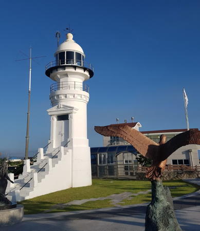

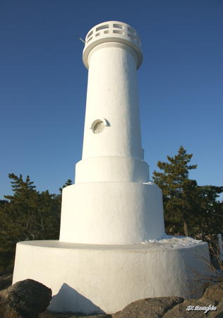
Jumunjin Light, Gangneung, July 2018
Google Maps photo by Chang Sung Park
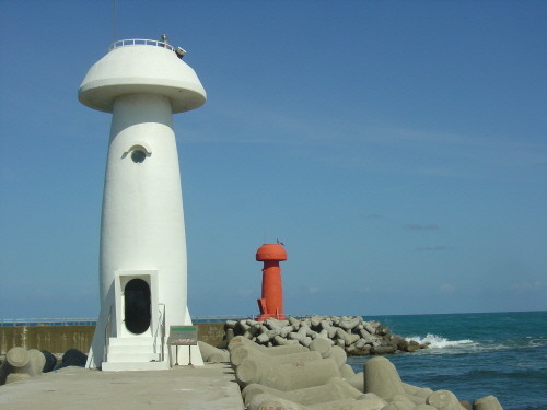
Yangyang County Lighthouses

Ganghyeon Township Lighthouses
* Mulchi Hang North Breakwater (2?)
Date unknown. Active; focal plane 14 m (46 ft); red flash every 5 s. 11 m (36 ft) round mushroom-shaped concrete tower, painted red. A photo is at right, Chunglae Seon has another photo of both lighthouses, Moonsoo Park has a street view along the pier, and Google has a satellite view. Located on the north breakwater of Mulchi harbor, about 7 km (4 mi) south of Sokcho. Accessible by walking the pier. Site open, tower closed. KR-1221.5; Admiralty M4456.9; NGA 16421.
* Mulchi Hang South Breakwater (2?)
Date unknown. Active; focal plane 15 m (49 ft); green flash every 5 s. 11 m (36 ft) round mushroom-shaped concrete tower, painted white. A photo is at right, Chunglae Seon has another photo of both lighthouses, Moonsoo Park has a street view from the north breakwater, and Google has a satellite view. Located on the south breakwater of Mulchi harbor, about 7 km (4 mi) south of Sokcho. Accessible by walking the pier. Site open, tower closed. KR-1221.6; Admiralty M4456.93; NGA 16422.
* Hujin Hang (2)
Date unknown. Active; focal plane about 15 m (49 ft); red flash every 4 s. Approx. 12 m (39 ft) round concrete tower with lantern and gallery. Entire lighthouse is red. A 2022 closeup is available, Hyeran Lee has a 2021 photo, Park Jung-seo has a distant 2019 street view, and Google has satellite view. This lighthouse replaced a shorter skeletal tower seen in Google's 2014 street view. Located at the end of the main breakwater of Hujin harbor, about 1.5 km (1 mi) southeast of Mulchi Hang. KR-1221.8; Admiralty M4456.85; NGA 16423.
* Jeonjin Hang North Breakwater
Date unknown. Active; focal plane 16 m (52 ft); red flash every 5 s. 11 m (36 ft) octagonal concrete tower painted red. A 2018 closeup photo is available and Google has a street view and a satellite view. Michael Yang's street view is taken from the base of the lighthouse. Located on the north breakwater of Jeonjin harbor. Accessible by walking the pier. Site open, tower closed. Admiralty M4456.8; NGA 16423.1.
Mulchi Hang Lights
Mulchi Hang Breakwater Lights, Yangyang, October 2008
Yangyang County photo (no longer online)

Sonyang Township Lighthouses
Susan Dan
Date unknown. Active; focal plane 73 m (240 ft); white flash every 5 s. 16 m (52 ft) round cylindrical concrete tower with gallery, painted white. Binnam Lee has a distant view (lighthouse atop the headland at right), a view from the harbor is available, and Google has a satellite view and a distant street view. Located on a hilltop north of Susan harbor. Site and tower closed. KR-1222; Admiralty M4456.5; NGA 16424.
* Susan Dan North Breakwater
Date unknown. Active; focal plane 17 m (56 ft); red flash every 4 s. 10 m (33 ft) round cylindrical concrete tower, painted red. Jongryong Kim has a street view and Google has a satellite view. Located at the end of the north breakwater of Susan harbor. Accessible by walking the pier. Site open, tower closed. KR-1222.2; Admiralty M4456.55.
* Susan Dan North Breakwater Spur
Date unknown. Active; focal plane 18 m (59 ft); two red flashes every 5 s. 10 m (33 ft) round cylindrical concrete tower, painted red. Jongryong Kim has a closeup street view and Google has a satellite view. Located at the end of a north-south spur attached to the north breakwater of Susan harbor. Accessible by walking the pier. Site open, tower closed. KR-1222.4; Admiralty M4456.555.
* Susan Dan South Breakwater
Date unknown. Active; focal plane 15 m (49 ft); green flash every 4 s. 10 m (33 ft) round cylindrical concrete tower, painted white. Jongryong Kim has a street view and Google has a satellite view. Located at the end of the south breakwater of Susan harbor. Accessible by walking the pier. Site open, tower closed. KR-1222.3; Admiralty M4456.56.

Hyeonbuk Township Lighthouses
* Gisamun Dan (Hajodae Beach)
Date unknown. Active; focal plane 32 m (105 ft); white flash every 6 s. 10 m (33 ft) round cylindrical concrete tower with gallery, painted white. Seongbin Im has the closeup photo seen at right, Park Geun Sung has a 2018 photo, Younghoon Jeong has a street view, and Google has a satellite view. Located on a promontory about 8 km (5 mi) southeast of Susan harbor. Accessible by a paved trail; parking provided. Site open, tower closed. . KR-1223; Admiralty M4456; NGA 16428.
* Gisamun Hang (2)
Date unknown. Active; focal plane 16 m (52 ft); red flash every 6 s. 11 m (36 ft) round mushroom-shaped concrete tower. Lighthouse painted red; formerly is was beige with the round mushroom top painted red. Lee Jeong-geun has a 2023 street view, Hunjung Park has a 2018 street view, and Google has a satellite view. Located on the breakwater of the small harbor sheltered by the cape of Gisamun Dan. Accessible by walking the pier. Site open, tower closed. KR-1223.1; Admiralty M4456.2; NGA 16429.

Gisamun Dan Light, Hajodae, January 2009
Flickr Creative Commons photo by Seongbin Im

Hyeonnam Township Lighthouses
* Dongsan Hang South Breakwater
Date unknown. Active; focal plane 15 m (49 ft); green flash every 4 s. 10 m (33 ft) round cylindrical concrete tower, painted white. Google has a satellite view and a distant street view. Located at the end of the south breakwater of Dongsan harbor. Accessible by walking the pier. Site open, tower closed. KR-1223.3; Admiralty M4455.61.
* [Namae Hang North Breakwater (3)]
2020. Active'; focal plane 15 m 949 ft); four yellow flashes every 8 s. 8 m (26 ft) round steel tower attached to a small equipment shelter. Tae-young Jang has a 2022 closeup, Jeong Hoekeun has a distant view and Google has a satellite view. Located on a new breakwater warning ships away from rocks on the north side of Namae. A graceful pedestrian bridge provides access to the breakwater. Site open, tower closed. KR-1225.2; Admiralty M4455.43.
* Namae Hang East Breakwater (3)
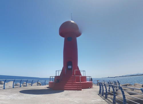
2008 (station establishment date unknown). Active; focal plane 19 m (59 ft); red flash every 4 s. 12 m (39 ft) round mushroom-shaped concrete tower, painted red. Kye Wondae's street view is at right, a closeup is available and Google has a street view and a satellite view. The first lighthouse was a skeletal tower seen in Dringe Augh's closeup photo. Located at the end of a breakwater on the north side of the entrance to the Namae River, about 4 km (2.5 mi) north of Jumunjin. The pier is at the south end of the popular Jumunjin beach, one of the longest sand beaches of Korea's east coast. Accessible by walking the pier. Site open, tower closed. Admiralty M4455; NGA 16432.
* Namae Hang South Breakwater
Date unknown. Active; focal plane 11 m (36 ft); green flash every 4 s. 6 m (20 ft) round cylindrical concrete tower, painted white. A photo is available and Google has a street view and a satellite view. Located at the end of the south breakwater of Namae harbor. Accessible by walking the pier. Site open, tower closed. KR-1225; Admiralty M4455.4; NGA 16433.

Namae Hang East Breakwater Light, Gangneung, September 2017
Google Maps street view by Kye Wondae

Gangneung (Kangnung) City Lighthouses

Jumunjin Town Lighthouses
* Uamjin (Sodol) Hang
Date unknown. Active; focal plane 15 m (49 ft); red flash every 5 s. 10 m (33 ft) round cylindrical concrete tower painted red. Joonho Sun has a 2020 photo and Google has a street view and a satellite view. Located on the north (main) breakwater of Uamjin harbor, on the north side of Jumunjin. Accessible by walking the pier. Site open, tower closed. KR-1225.5; Admiralty M4449.9; NGA 16435.1.
* Jumunjin (Chumujin Dan)
1918. Active; focal plane 40 m (131 ft); white flash every 7.5 s. 10 m (33 ft) round brick tower with lantern and gallery. 1-story brick keeper's house. Fog siren (one 5 s blast every 60 s). Chang Sung Park's photo is at the top of this page, J.G. Jeon has a 2019 closeup, Dongwon Kang has a 2022 closeup, a nice 2021 photo is available, and Google has a street view and a satellite view. The lighthouse was repaired after being damaged during fighting early in the Korean War. When the lighthouse was renovated in 2002 a public observation tower was built atop one of the auxiliary buildings. The station is a staffed communications facility. Located on a sharp promontory about 2.5 km (1.5 mi) north of Jumunjin. Site open, observation tower open daily, lighthouse tower closed. . ARLHS SKR-006; Admiralty M4450; NGA 16436.
* Jumunjin East Breakwater
Date unknown. Active; focal plane 14 m (46 ft); red flash every 4 s. 10 m (33 ft) round cylindrical concrete tower, painted red. Dringe Augh has a closeup photo that also shows the south breakwater light in the distance, Stuart Fraser has a photo of the east and south breakwater lights, a closeup photo is available, and Google has a satellite view and a distant street view. Located at the end of the east (outer) breakwater of Jumunjin. Accessible by walking the pier. Site open, tower closed. Admiralty M4452; NGA 16440.
* Jumunjin West Breakwater
Date unknown. Active; focal plane 14 m (46 ft); green flash every 4 s. 10 m (33 ft) round hourglass-shaped white concrete tower. Google has a satellite view and a distant street view. Located at the end of the west (inner) breakwater of Jumunjin. Accessible by walking the pier. Site open, tower closed. KR-1229; Admiralty M4452.5; NGA 16444.
* Jumunjin South Breakwater (No. 2 Jetty)
Date unknown. Active; focal plane 11 m (36 ft); green flash every 4 s. 8.5 m (28 ft) round cylindrical concrete tower, painted white. Matthew Pate has a photo, and Stuart Fraser has a closeup and a photo of the east and south breakwater lights, and Google has a satellite view and a distant street view. Located at the end of the original south breakwater of Jumunjin. Accessible by walking the pier. Site open, tower closed. KR-1230; Admiralty M4453; NGA 16448.
Jumunjin Outer Breakwater North End
Date unknown. Active; focal plane about 15 m (49 ft); four yellow flashes every 8 s. 12 m (39 ft) round concrete tower rising from a pyramidal base. Entire lighthouse is yellow. Jong-Yeol Lee has the photo at right and Google has a satellite view and a very distant street view. The outer breakwater, just outside the harbpr entrance, was added sometime after Google's 2014 street views. Accessible only by boat. Site open, tower closed. KR-1228.2; Admiralty M4451.8.

Jumunjin Outer Breakwater North End Light, Gangneung, November 2018
Google Maps photo by Jong-Yeol Lee
Jumunjin Outer Breakwater South End
Date unknown. Active; focal plane about 15 m (49 ft); red flash every 4 s. 12 m (39 ft) round concrete tower painted red. A 2021 photo is available and Google has a satellite view. Accessible only by boat. Site open, tower closed. KR-1228.1; Admiralty M4451.9.

Yeongok Township Lighthouse
* Yeongjin Hang
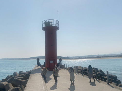
Date unknown. Active; focal plane 16 m (52 ft); red flash every 6 s. 10 m (33 ft) round cylindrical concrete tower painted red. Lee Hyun Woo has the street view at right and Google has a street view and a satellite view. Located on the east (main) breakwater of Yeongjin harbor, about 2.5 km (1.5 mi) southeast of Jumanjin. Accessible by walking the pier. Site open, tower closed. KR-1230.3; Admiralty M4449.88.

Sacheon Township Lighthouses
* Sacheon (Sach'onjin) North Breakwater (2)
2021. Active; focal plane 15 m (49 ft); red flash every 5 s. 10 m (33 ft) round cylindrical concrete tower with lantern and gallery, painted red. Ji Ho-young has a 2022 view of the three breakwater lighthouses and Google has a satellite view. The breakwater was extended about 100 m (330 ft) in 2020 and a new light was installed; Hee Tae Chang has a 2013 photo of the earlier light and Google has a fuzzy 2015 street view. Located near (but not at) the end of the north breakwater of Sacheon harbor in Gangneung. Accessible by walking the pier. Site open, tower closed. KR-1231; Admiralty M4449.8; NGA 16451.
* Sacheon (Sach'onjin) Inner Breakwater
2021. Active; focal plane 12 m (39 ft); green light, pattern unknown. 10 m (33 ft) round cylindrical concrete tower with lantern and gallery, painted white. This light is on the left in Ji Ho-young's 2022 view and Google has a satellite view. Located at the end of the south breakwater of Sacheon harbor in Gangneung. Accessible by walking the pier. Site open, tower closed. Admiralty M4449.86.

Yeongjin Hang East Breakwater Light, Gangneung, February 2021
Google Maps street view by Lee Hyun Woo
* Sacheon (Sach'onjin) South Breakwater (2)
2020. Active; focal plane 12 m (39 ft); green flash every 5 s. 10 m (33 ft) round cylindrical concrete tower with lantern and gallery, painted white. Dae-y Lee has a November 2020 photo (also showing the original North Breakwater light), this light is on the right in Ji Ho-young's 2022 view, and Google has a satellite view. A 2020 photo of the original light is available and Google has a fuzzy street view. Located at the end of the south breakwater of Sacheon harbor in Gangneung. Accessible by walking the pier. Site open, tower closed. KR-1232; Admiralty M4449.85; NGA 16451.5.
Sandaewol-ri
Date unknown. Active; focal plane about 10 m (33 ft); three quick white flashes every 10 s. 10 m (33 ft) round cylindrical concrete tower painted black with a yellow horizontal band. Google has a distant street view and Bing has an indistinct satellite view. Located about 300 m (0.2 mi) offshore about 1.5 km (1 mi) southeast of Sacheon harbor. Accessible only by boat. Site open, tower closed. KR-1232.1; Admiralty M4449.78.

Gangneung City Lighthouses
Gaiam South
Date unknown. Active; focal plane about 10 m (33 ft); two white flashes every 5 s. Approx. 10 m (33 ft) round cylindrical concrete tower painted black with a red horizontal band. Jongyeol Lee has a street view from the beach and Google has an indistinct satellite view. Located about 300 m (0.2 mi) offshore at Haean-Ro on the north side of Gangneung. Accessible only by boat. Site open, tower closed. KR-1231.6; Admiralty M4449.77.
* Gangneung (Anmok) North Breakwater
Date unknown. Active; focal plane 18 m (59 ft); red flash every 5 s. 10 m (33 ft) round cylindrical concrete tower, painted red. Hyungjun Kim's photo is at right, another photo is available, Rae Gwak has a street view, and Google has a satellite view. Located at the end of the north breakwater of Anmok harbor in Gangneung. Accessible by walking the pier. Site open, tower closed. KR-1232.3; Admiralty M4449.7; NGA 16451.6.
* Gangneung (Anmok) South Breakwater
Date unknown. Active; focal plane 18 m (59 ft); green flash every 5 s. 10 m (33 ft) round cylindrical concrete tower, painted white. Rae Gwak has a street view and Google has a satellite view. Located at the end of the south breakwater of Anmok harbor in Gangneung. Accessible by walking the pier. Site open, tower closed. KR-1232.4; Admiralty M4449.75; NGA 16451.65.

Anmok Hang North Breakwater Light, Gangneung, August 2021
Google Maps photo by Hyungjun Kim

Gangdong Township Lighthouses
Aninhwaryeok Breakwater North End
2022. Active; focal plane 21 m (69 ft); four yellow flashes every 8 s. 14 m (46 ft) yellow concrete tower. No photo available but Google has a satellite view. Located at the north end of a new detached outer breakwater at Aninjin. Accessible only by boat. Site status unknown. KR-1233.2; Admiralty M4449.58.
* Aninjin Breakwater
2014. Active; focal plane 15 m (49 ft); red flash every 4 s. 10 m (33 ft) round cylindrical concrete tower, painted red. Jinkyo Jung has a 2019 photo, a photo of both breakwater lights is available, and Google has a street view and a satellite view. Located at the end of the north breakwater of Aninjin harbor. Accessible by walking the pier. Site open, tower closed. KR-1232.5; Admiralty M4449.6; NGA 16451.7.
* Aninjin Groyne
2014. Active; focal plane 15 m (49 ft); green flash every 4 s. 10 m (33 ft) round cylindrical concrete tower, painted white. A photo and a photo of both breakwater lights are available, and Google has a street view and a satellite view. Located at the end of the south breakwater of Aninjin harbor. Accessible by walking the pier. Site open, tower closed. Admiralty M4449.65; NGA 16451.8.
Jeongdongjin (Chongdongjin) Dan
Date unknown. Active; focal plane 89 m (292 ft); white flash every 8 s. 10 m (33 ft) round white concrete tower. No closeup photo available but Google has a distant satellite view and a very distant street view. Located on a prominent headland about 12 km (7.5 mi) southeast of Gangneung. Site status unknown. Admiralty M4449.5; NGA 16452.
* Simgok Hang (2)
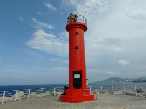
Date unknown. Active; focal plane about 16 m (52 ft); red flash every 4 s. Approx. 12 m (39 ft) round cylindrical concrete tower with lantern and gallery. Entire lighthouse is red. Seong-Gi Park's photo is at right and Google has a 2018 street view and a satellite view. The first light was a skeletal tower seen in a 2015 street view. Located at the end of the breakwater at Simgok, about 1 km (0.6 mi) south of Jeongdongjin Dan. Accessible by walking the pier. Site open, tower closed. KR-1233.5; Admiralty M4449.4; NGA 16453.

Okgye Township Lighthouses
* Geumjin Hang Breakwater
Date unknown. Active; focal plane 16 m (52 ft); red flash every 5 s. 10 m (33 ft) round cylindrical concrete tower, painted red. Dongwoo Seo has a photo of both breakwater lights and Google has a street view and a satellite view. Located at the end of the north breakwater of Geumjin harbor, about 16 km (10 mi) north of Donghae. Accessible by walking the pier. Site open, tower closed. KR-1234; Admiralty M4449.3; NGA 16449.

Simgok Hang Breakwater Light, Gangneung, July 2021
Google Maps photo by Seong-Gi Park
* Geumjin Hang Groyne
Date unknown. Active; focal plane 12 m (39 ft); green flash every 5 s. 10 m (33 ft) round cylindrical concrete tower, painted red. Go Hyeong-seok has a 2023 photo, Dongwoo Seo has a photo of both breakwater lights, and Google has a street view and a satellite view. Located at the end of the south breakwater of Geumjin harbor, about 16 km (10 mi) north of Donghae. Accessible by walking the pier. Site open, tower closed. KR-1235; Admiralty M4449.35; NGA 16450.
* Okgye Hang North Breakwater
Date unknown. Active; focal plane 15 m (49 ft); red flash every 4 s. 10 m (33 ft) round cylindrical concrete tower, painted red. No photo available but Google has a satellite view and a very distant street view. YongJin Na has an aerial view of this industrial harbor. Located at the end of the north breakwater of Okgye harbor, about 11 km (7 mi) north of Donghae. Accessible by walking the pier. Site open, tower closed. Admiralty M4449.1; NGA 16454.
* Okgye Hang South Breakwater
Date unknown. Active; focal plane 15 m (39 ft); green flash every 4 s. 10 m (33 ft) round cylindrical concrete tower, painted red. Taekjoo Jin has a distant view and Google has a satellite view and a very distant street view. Located at the end of the south breakwater of Okgye harbor, about 11 km (7 mi) north of Donghae. Accessible by walking the pier. Site open, tower closed. Admiralty M4449.2; NGA 16454.1.
 

Information available on lost lighthouses:

Notable faux lighthouses:

Adjoining pages: North: Sokcho Area | South: Donghae and Samcheok

Return to the Lighthouse Directory index | Ratings key

Posted October 29, 2007. Checked and revised October 6, 2023. Lighthouses: 38. Site copyright 2023 Russ Rowlett and the University of North Carolina at Chapel Hill.