Lighthouses of South Korea: Changwon

For most of its history Korea was an independent kingdom, or at least an autonomous kingdom under Chinese influence. This came to an end in 1910 when Japan annexed all of Korea. At the end of World War II in 1945 the 38° parallel was established as the dividing line between U.S. and Soviet zones of occupation, and in 1948 separate civil administrations were established in the two halves of the country. The Korean War (1950-53) ended in a draw with the armistice line falling close to the prewar 38° line. The Republic of Korea (ROK), commonly called South Korea, occupies the Korean peninsula south of the armistice line.

The name Korea, used internationally, is a Western version of Goryeo or Koryŏ (고려), the name of a kingdom that unified the country in the tenth century. From 1392 to 1897 the kingdom was known instead as Joseon or Chosŏn (조선). Today South Koreans usually call their country Hanguk (한국, literally "one country") and the official name of the Republic of Korea is Daehan Minguk (대한민국).

South Korea is divided into nine provinces and eight province-level cities. This page covers lighthouses of the city of Changwon in Gyeongsangnam (South Gyeongsang) province on South Korea's south coast, west of the major port of Busan. In July 2010 Changwon, the capital of Gyeongsangnam, merged with the seaport cities of Jinhae (Chinhae) and Masan to form the Unified City of Changwon. The combined city has a population of more than one million.

Navigational aids in the ROK are regulated by the Ministry of Oceans and Fisheries (MOF). Management of lighthouses in Changwon is the responsibility of the Masan Regional Office of Oceans and Fisheries. The Korean Hydrographic and Oceanographic Administration (KHOA) publishes notices to mariners.

In 2000 South Korea adopted a Revised Romanization System to replace systems formerly used in the West. In the Revised System, the word for a lighthouse is deungdae (등대); dan (formerly tan) is a cape, seom (som) or do (to) is an island, am or amseog is a rock, man is a bay, and hang is a harbor. Some place names may be more familiar to Westerners in the spellings of older systems.

ARLHS numbers are from the ARLHS World List of Lights. KR numbers, where available, are from the Korean light list. Admiralty numbers are from volume M of the Admiralty List of Lights & Fog Signals. U.S. NGA List numbers are from Publication 112.

General Sources
Online List of Lights - Korea
Photos by various photographers posted by Alexander Trabas.
Lighthouses to Visit
Information on three lighthouses provided by the Masan Office of Oceans and Fisheries.
KHOA - Notices to Mariners
Notices provided by the Korea Hydrographic and Oceanographic Agency.
Navionics Charts
Navigation chart for the Changwon area.
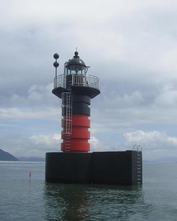
Songnaedo Light
Songnaedo Light, Masan, 2008
Masan Regional Office of Oceans and Fisheries photo
Jinhae District Lighthouses

Busan Sin Hang (Busan New Port) Lighthouses (see also Southern Busan)
These lights serve new port facilities being developed at the western edge of the Busan municipality. The port itself straddles the line between Busan and Jinhae, but the approach is through channels mostly within Jinhae.

Jangmal South Breakwater (2)
Date unknown. Active; focal plane 13 m (43 ft); red flash every 10 s. 10 m (33 ft) round concrete tower, painted red. No photo available but Google has a satellite view. Located at the end of a breakwater at the southwestern corner of the new port development. Site status unknown. KR-2071.9; Admiralty M4351.2; NGA 16781.
* Angolpo Breakwater (?)
Date unknown. Active (?); focal plane 13 m (43 ft); red flash every 5 s. 11 m (36 ft) octagonal cylindrical concrete tower with gallery, painted red. Jang Ho-gun's 2018 photo is at right, a closeup is available, and Google has a fuzzy satellite view. This light has been dropped from the Admiralty list but it is listed by NGA and charted by Navionics. Located on the breakwater of a recreational harbor at the west end of the New Port development area. Accessible by walking the pier. Site open, tower closed. KR-2072.40; ex-Admiralty M4351.15; NGA 16781.5.
Busan New Port Exit (Leading) (?)
2019. Active; focal plane 40 m (131 ft); continuous light, white, red or green depending on direction. 36 m (118 ft) robust steel mast. No photo available but Bing has a satellite view. The lights leads ships departing the harbor. This light was removed from the Korean list in 2019 but it is still listed by the Admiralty and charted as active by Navionics. Located at the west end of Busan Sin Hang. Site status unknown. ex-KR-2071.1; Admiralty M4351.12.

Angolpo Breakwater Light, Jinhae, December 2018
Google Maps photo by Jang Ho-gun
Busan New Port Range Front
Date unknown. Active; focal plane 105 m (344 ft); continuous green light. 100 m (328 ft) square pyramidal skeletal tower. Sergey Petrov has a drone view and Google has a satellite view. This is the entrance range for Busan Sin Hang. Located at the northeast corner of Yeondo. Site status unknown. KR-2070.8; Admiralty M4351.1; NGA 16789.
Busan New Port Range Rear
Date unknown. Active; focal plane 194 m (636 ft); continuous green light. 42 m (138 ft) square pyramidal skeletal tower. Junsik Kim has a photo, Jae Hong Park has a view, and Google has a satellite view. Located on a ridge about 2.5 km (1.5 mi) north northwest of the front light. Site status unknown. KR-2070.9; Admiralty M4351.11; NGA 16789.1.
Yeondo
2007. Active; focal plane 129 m (423 ft); white flash every 4 s. 29 m (95 ft) round white concrete tower. No closeupo photo available but Seong-Hoon Kim has a very distant view, Sergey Petrov has a drone view, and Google has a satellite view. Located on a small but high island in the entrance to Busan New Port. Accessible only by boat. Site status unknown. KR-2072.25; Admiralty M4351.28.
Gadeokdo West Breakwater (2)
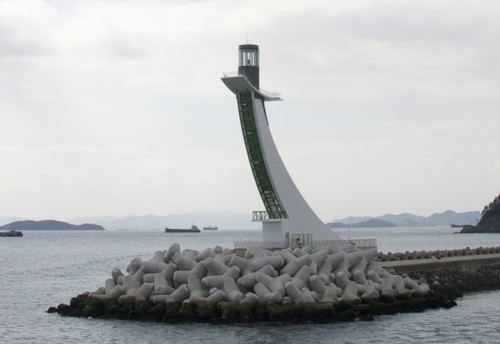
2008 (station establishment date unknown). Active; focal plane 38 m (125 ft); green flash every 4 s. 27 m (89 ft) square concrete tower with lantern and gallery, painted white with a green vertical stripe; lantern painted green. The tower sweeps upward in a 1/4-circle arc. Kim Cheol Hwan's photo is at right, Jinnyeon Kim has a view along the breakwater, and Google has a satellite view. The East Breakwater Light is described on the Southern Busan page. Located at the end of the breakwater, which extends southeastward from Yeondo. Site status unknown. KR-2071.6; Admiralty M4351.3; NGA 16783.
Gadeokdo West Breakwater Light
Gadeokdo West Breakwater Light, Jinhae, October 2010
ex-Panoramio Creative Commons photo by Kim Cheol Hwan

Jinhae Harbor Lighthouses
Gotdo Breakwater
2007. Active; focal plane 23 m (75 ft); green flash every 4 s. 20 m (66 ft) round cylindrical concrete tower with lantern and gallery. Entire lighthouse is white. Park Sang-yong has a view across the harbor and Google has a satellite view. Gotdo is an island at the southeastern end of Jinhae harbor, about 3 km (1.8 mi) northwest of Yeondo. Located at the end of a breakwater enclosing a small harbor on the northwest side of the island. Site status unknown. Admiralty M4345.31.
Jedeongman
Date unknown (recent). Active; focal plane 17 m (56 ft); two white flashes every 5 s. 19 m (62 ft) round cylindrical concrete tower with lantern and gallery, upper half painted yellow and lower half black. Kim Cheol Bong has a photo and Google has a satellite view. Located on a reef northwest of Gotdo. Accessible only by boat. Site status unknown. KR-2077.10; Admiralty M4345.35; NGA 16793.
* Sampo Hang
2019. Active; focal plane 11 m (36 ft); green flash every 4 s. 9 m (30 ft) octagonal cylindrical white concrete tower. A 2021 closeup photo and a second photo are available and Google has a satellite view. Located on a short breakwater at Sampo. Accessible by walking the pier. Site open, tower closed. KR-2077.32; Admiralty M4345.37.
* Myeongdong Marina
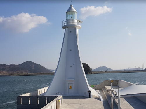
2017. Active; focal plane 20 m (66 ft); two green flashes every 6 s. 15 m (49 ft) round white concrete tower with lantern and gallery and three sweeping buttresses. Kang Chun Hui has the closeup photo seen at right and Google has a satellite view. Located at the end of a breakater sheltering small boat harbors on Udo island in the Myeong Ward (Myeongdong). Accessible by walking the pier. Site open, tower closed. Admiralty M4345.38; NGA 16806.
Sogodo (Umjido) (?)
Date unknown. Active; focal plane 11 m (36 ft); two white flashes every 5 s. 13 m (43 ft) concrete post with gallery, mounted on a round concrete base and painted black with one red horizontal band. Lee Byungsoo has a street view and Google has a satellite view. This light was removed from the Korean list in 2019 but it is still listed by the Admiralty and charted as active by Navionics. Located on an isolated rock off the west side west of Umji island. Accessible only by boat. Site open, tower closed. ex-KR-2077.11; Admiralty M4345.3; NGA 16805.
 

Myeongdong Marina Light, Jinhae, December 2017
Google Maps photo by Kang Chun Hui
 
Tokkiseom (Doggi Seom, Toggi Seom) (2)
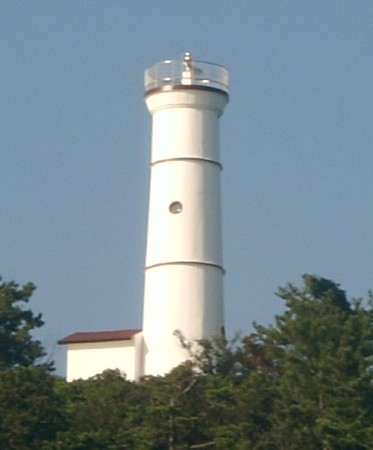
2005 (station establishment date unknown). Active; focal plane 68 m (223 ft); white flash every 4 s. 15 m (49 ft) round cylindrical concrete tower with gallery, attached to a small 1-story service building. Lighthouse painted white. A photo is at right and Google has a satellite view. Located on a small but high island southwest of Udo island in the entrance to the harbor of Jinhae. Accessible only by boat. Site status unknown. Admiralty M4345; NGA 16792.
Chorido (Ch'ori Do) (2?)
Date unknown. Active; focal plane 49 m (161 ft); white flash every 6 s. 12 m (39 ft) round cylindrical concrete tower, painted white. Kim Cheol Bong has a very distant view and Google has a satellite view. Located on the west end of an island about 2.5 km (1.5 mi) west of the Doggi Seom light. Accessible only by boat. Site status unknown. KR-2081; Admiralty M4344; NGA 16796.
Dochinyeo (Che Roe Channel Reef)
Date unknown. Active; focal plane 10 m (33 ft); two white flashes every 5 s. 12 m (39 ft) round tower with gallery, painted black with one red horizontal band. No photo available but Google has a satellite view. Located on a reef on the east side of the entrance to the harbor of Jinhae, about 1.2 km (3/4 mi) west of the Chorido light. Accessible only by boat. Site open, tower closed. KR-2091; Admiralty M4343; NGA 16808.
Dotumariam (Dotumariseom) (2)
2007 (station establishment date unknown). Active; focal plane 14 m (46 ft); red flash every 4 s. 14 m (46 ft) round hourglass-shaped concrete tower with lantern and gallery, plus four piles supporting the gallery. Lighthouse painted black with one red horizontal band. Kim Cheol Bong has a photo and Google has a satellite view. Located at the east end of a reef on the west side of the entrance to Jinhae harbor. Accessible only by boat. Site status unknown. KR-2093; Admiralty M4346; NGA 16804.
Madangseo (Budo Sudo, Pudo Suido, Changwon)
Date unknown. Active; focal plane 14 m (46 ft); two white flashes every 5 s. 13 m (43 ft) round tower with lantern and gallery, painted black with one red horizontal band. No photo available but Google has a satellite view. Located on an isolated rock in the entrance to Haengam Bay, the inner harbor of Jinhae. Accessible only by boat. Site status unknown. KR-2094; Admiralty M4347; NGA 16800.
Jungjukdo (Chungjukdo, Chungjuk To)
Date unknown. Active; focal plane 14 m (46 ft); two white flashes every 5 s. 14 m (46 ft) octagonal hourglass-shaped tower with gallery, painted black with one red horizontal band. Kim Cheol Bong has a photo, Lee Chung Hee has a very distant street view and Google has a satellite view. Located on an isolated rock in the very center of Jinhae harbor. Accessible only by boat. Site status unknown. Admiralty M4347.5; NGA 16802.
Tokkiseom
Tokkiseom Light, Jinhae
Masan Maritime Affairs and Port Office photo
* Jinhae Hang Breakwater
Date unknown. Active; focal plane 12 m (39 ft); green flash every 4 s. 10 m (33 ft) round cylindrical white concrete tower with gallery. Kim Jong Min has a photo, Kim Cheol Bong has a closeup, and Google has a satellite view. The breakwater was extended in recent years and the lighthouse was relocated to the new endpoint. Located at the end of a breakwater on the west side of Jinhae's inner harbor. Accessible by walking the pier. Site open, tower closed. KR-2099.1; Admiralty M4347.7; NGA 16803.

Masanhappo District Lighthouses

Masan Harbor Lighthouses
Makgaedo (Maggaedo, Makkae Do) (2)
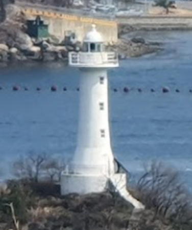
Date unknown (early 2010s). Active; focal plane 25 m (82 ft); white flash every 6 s. 15 m (49 ft) round white concrete tower with lantern and gallery. Youngmin Joo's 2021 photo is at right, Inho Kim has a 2018 photo, Gong Eulho has a 2015 view, and Google has a satellite view. The earlier tower was 10 m (33 ft) tall and had no lantern. Makgaedo is a small island in the main channel of Masan Bay about 6 km (3.5 mi) south of the city of Masan. Located on the highest point of the island. Accessible only by boat. Site status unknown. KR-2107; Admiralty M4348; NGA 16816.
* Masan Hang East Breakwater East Head
Date unknown. Active; focal plane 8.5 m (28 ft); green flash every 4 s. 6.5 m (21 ft) round white concrete tower. No photo available but Google has a satellite view. Located at the east end of a T-shaped pier at the east end of Masan harbor. Accessible by walking the pier. Site open, tower closed. KR-2112; Admiralty M4349.7; NGA 16811.
* Masan Hang East Breakwater West Head
Date unknown. Active; focal plane 8.5 m (28 ft); red flash every 4 s. 6.5 m (21 ft) round red concrete tower. No photo available but Google has a satellite view. Located at the west end of a T-shaped pier at the east end of Masan harbor. Accessible by walking the pier. Site open, tower closed. KR-2113; Admiralty M4349.8; NGA 16812.
Masan Hang Detached Breakwater East End
Date unknown. Active; focal plane 11 m (36 ft); green flash every 6 s. 10 m (33 ft) round white concrete tower. Cài Shànghuà has a distant view, Michael Black has a distant 2023 view, and Google has a satellite view. Located at the east end of the detached breakwater protecting the central section of the Masan waterfront. Accessible only by boat. Site status unknown. KR-2114; Admiralty M4349.2; NGA 16813.
Masan Hang Detached Breakwater West End
Date unknown. Active; focal plane 11 m (36 ft); red flash every 6 s. 10 m (33 ft) round red concrete tower. Vincent Lee has a view across the harbor, Michael Black has a 2023 view, and Google has a satellite view. Located at the east end of the detached breakwater protecting the central section of the Masan waterfront. Accessible only by boat. Site status unknown. KR-2115; Admiralty M4349.3; NGA 16814.
* Masan Hang West Breakwater East Head
Date unknown. Active; focal plane 10 m (33 ft); green flash every 4 s. 8 m (26 ft) white metal tower. This light is at the left in a 2020 photo and Google has a satellite view. Located at the east end of a T-shaped pier at the west end of Masan harbor. Accessible by walking the pier. Site open, tower closed. KR-2116; Admiralty M4348.8; NGA 16815.

Makgaedo Light, Masan, March 2021
Google Maps photo by Youngmin Joo
* Masan Hang West Breakwater West Head
Date unknown. Active; focal plane 10 m (33 ft); red flash every 4 s. 8 m (26 ft) red metal tower. The light is seen in the center of a 2020 photo and at the lower left in Kim Young-do's photo, and Google has a satellite view. Located at the west end of a T-shaped pier at the west end of Masan harbor. Accessible by walking the pier. Site open, tower closed. KR-2117; Admiralty M4348.9; NGA 16815.5.
* Masan Hang South Breakwater
Date unknown. Active; focal plane 13 m (43 ft); green flash every 4 s. 10 m (33 ft) round white concrete tower. This light is at the right in a 2020 photo, Ju Hyun Jin has a photo, Vincent Lee has a view along the pier, Kim Young-do has a photo, and Google has a distant satellite view. Located at the end of the south breakwater, marking the entrance to the inner harbor of Masan. Accessible by walking the pier. Site open, tower closed. KR-2117.1; Admiralty M4348.7; NGA 16815.9.

Gusan Ward Lighthouses
Wonjeon Hang Detached Breakwater East End
2007(?). Active; focal plane 13 m (43 ft); green flash every 4 s. 9 m (30 ft) round concrete tower with gallery, painted white. Kim Cheol Bong's photo of the two breakwater lighthouses is at right and Google has a satellite view. The breakwater has been extended and the lighthouse may be relocated. Wonjeon Hang is a small-craft harbor on the southwest side of Jinhae Bay, northwest of the Dotumariam reef. Located at the east end of the detached breakwater. Accessible only by boat. Site open, tower closed. KR-2101.3; Admiralty M4342.51; NGA 16817.4.
Wonjeon Hang Detached Breakwater West End
2007(?). Active; focal plane 13 m (43 ft); red flash every 4 s. 9 m (30 ft) round concrete tower with gallery, painted red. Kim Cheol Bong's photo of the two breakwater lighthouses is at right and Google has a satellite view. Located at the west end of the detached breakwater. Accessible only by boat. Site open, tower closed. KR-2101.4; Admiralty M4342.52; NGA 16817.5.
* Wonjeon Hang West Breakwater (2)
2007(?). Active; focal plane 13 m (43 ft); green flash every 4 s. 9 m (30 ft) round concrete tower with gallery, painted white. Kim Cheol Bong has a closeup, Kim Bo-jung has a more distant view, and Google has a satellite view. There were many improvements to Wonjeon harbor in 2007; these included an extension of the west breakwater at a sharp angle with the original, plus construction of a detached breakwater (see previous entries). Located at the end of the west breakwater. Accessible by walking the pier. Site open, tower closed. KR-2101.5; Admiralty M4342.5; NGA 16817.3.
Beugam (Paegam)
Date unknown. Active; focal plane 14 m (46 ft); green flash every 5 s. 13 m (43 ft) hexagonal concrete tower, painted green. Kim Cheol Bong has a distant photo and Google has a satellite view. Located on a rocky reef off the northern tip of Geojedo, in the northern entrance to the bay of Tongyeong. Accessible only by boat. Site status unknown. KR-2134; Admiralty M4342.4; NGA 16818.
Wonjeon Hang Breakwater Lights
Wonjeon Hang Breakwater Lights, Masan, February 2014
ex-Panoramio photo copyright Kim Cheol Bong; used by permission
Heugam (Hugam)
Date unknown. Active; focal plane 11 m (36 ft); two white flashes every 5 s. 13 m (43 ft) round concrete tower, painted black with one red horizontal band. Kim Cheol Bong has a distant view and Google has a satellite view. Located on a reef in western Tongyeong Bay about 3 km (1.8 mi) north of Hwangdeokdo. Accessible only by boat. Site open, tower closed. KR-2135; Admiralty M4342; NGA 16819.
Bokjingaeyeo
Date unknown. Active; focal plane 7 m (23 ft); green flash every 4 s. 8 m (26 ft) round green concrete tower. Y.B. Kim has a photo, Kim Cheol Bong has a closeup, and Google has a satellite view. Located on a reef just off the east coast of the large island of Jeodo. Accessible only by boat but there's a good view from shore. Site open, tower closed. KR-2136; Admiralty M4341.7; NGA 16820.5.
Sogyedo
Date unknown. Active; focal plane 9 m (30 ft); two white flashes every 5 s. 12 m (39 ft) round concrete tower, painted black with one red horizontal band. Kim Cheol Bong has a photo and Google has a satellite view. Located on a reef in the northeastern corner of Myeongju Bay. Accessible only by boat. Site open, tower closed. Admiralty M4341.9.
Songnaedo (2?)
2008 (station establishment date unknown). Active; focal plane 15 m (49 ft); two white flashes every 5 s. 16 m (52 ft) round cylindrical concrete tower with lantern and gallery, mounted on a concrete pier. Lighthouse painted black with a red horizontal band. An MOF photo is at the top of this page and Google has an indistinct satellite view. NGA incorrectly lists this light as Suu-do. Located on a reef in the entrance to the northwestern corner of Myeongju Bay, about 16 km (10 mi) southwest of the city's waterfront. Accessible only by boat. Site open, tower closed. KR-2135.8; Admiralty M4340.984; NGA 16821.2.

Bokjingaeyeo Light, Masan, February 2014
Google Maps photo by Kim Cheol Bong

Western Jindong Ward Lighthouses
Suudo
Date unknown. Active; focal plane 10 m (33 ft); three quick white flashes every 10 s. 13 m (43 ft) concrete tower painted black with one yellow horizontal band. No photo available but Google has a satellite view. Located off the eastern tip of an island about 2 km (1.25 mi) east of Gwangam. Accessible only by boat. Site open, tower closed. KR-2135.19; Admiralty M4340.986.
* Gwangam Hang Breakwater
Date unknown. Active; focal plane 12 m (39 ft); red flash every 4 s. 7 m (23 ft) round cylindrical concrete tower. Entire lighthouse is red. Ganghyun Choi has a closeup photo, Kim Cheol Bong has a photo, and Google has a satellite view. Located on the main breakwater of the Gwangham harbor in Masanhappo. Accessible by walking the pier. Site open, tower closed. KR-2137; Admiralty M4340.98; NGA 16821.
* Jindong Hang East Breakwater
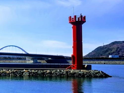
Date unknown. Active; focal plane 10 m (33 ft); red flash every 6 s. 8 m (26 ft) round hourglass-shaped concrete tower. Entire lighthouse is red. Kim Cheol Bong has a closeup photo (also seen at right) and Google has a satellite view. Located on the east breakwater of the Jindong small boat harbor. Accessible by walking the pier. Site open, tower closed. KR-2137.2; Admiralty M4340.978; NGA 16820.9.
* Jindong Hang West Breakwater
Date unknown. Active; focal plane 10 m (33 ft); green flash every 4 s. 8 m (26 ft) round hourglass-shaped concrete tower. Entire lighthouse is white. Kim Cheol Bong has a closeup photo and Google has a satellite view. Located on the west breakwater of the Jindong small boat harbor. Accessible by walking the pier. Site open, tower closed. KR-2137.1; Admiralty M4340.979; NGA 16820.93.

Jindong Hang East Breakwater Light, Masanhappo, February 2014
Google Maps photo copyright Kim Cheol Bong; used by permission

Information available on lost lighthouses:

Notable faux lighthouses:

Adjoining pages: East: Southern Busan | South: Geoje

Return to the Lighthouse Directory index | Ratings key

Posted December 4, 2007. Checked and revised December 19, 2023. Lighthouses: 39. Site copyright 2023 Russ Rowlett and the University of North Carolina at Chapel Hill.