Lighthouses of South Korea: Southern Busan

For most of its history Korea was an independent kingdom, or at least an autonomous kingdom under Chinese influence. This came to an end in 1910 when Japan annexed all of Korea. At the end of World War II in 1945 the 38° parallel was established as the dividing line between U.S. and Soviet zones of occupation, and in 1948 separate civil administrations were established in the two halves of the country. The Korean War (1950-53) ended in a draw, with the armistice line falling close to the prewar 38° line. The Republic of Korea (ROK), commonly called South Korea, occupies the Korean peninsula south of the armistice line.

The name Korea, used internationally, is a Western version of Goryeo or Koryŏ (고려), the name of a kingdom that unified the country in the tenth century. From 1392 to 1897 the kingdom was known instead as Joseon or Chosŏn (조선). Today South Koreans usually call their country Hanguk (한국, literally "one country") and the official name of the Republic of Korea is Daehan Minguk (대한민국).

South Korea is divided into nine provinces and eight province-level cities. This page covers lighthouses of the southern part of the province-level city of Busan on South Korea's southeast coast. With a population of more than 3.5 million, Busan (formerly spelled Pusan) is Korea's second largest city and largest port. The city faces the Korea Strait, which connects the East Sea (commonly called the Sea of Japan in the West) to the East China Sea. It stands on an intricate and rocky coast, with numerous islands of all sizes offshore.

Navigational aids in the ROK are regulated by the Ministry of Oceans and Fisheries (MOF). Management of lighthouses in Busan is the responsibility of the Busan Regional Oceans and Fisheries Administration. The Korean Hydrographic and Oceanographic Administration (KHOA) publishes notices to mariners.

In 2000 South Korea adopted a Revised Romanization System to replace systems formerly used in the West. In the Revised System, the word for a lighthouse is deungdae (등대); dan (formerly tan) is a cape, seom (som) or do (to) is an island, am or amseog is a rock, man is a bay, and hang is a harbor. Some place names may be more familiar to Westerners in the spellings of older systems.

ARLHS numbers are from the ARLHS World List of Lights. KR numbers, where available, are from the Korean light list. Admiralty numbers are from volume M of the Admiralty List of Lights & Fog Signals. U.S. NGA List numbers are from Publication 112.

General Sources
Kiso's Lighthouses - Korea
Photos posted by a Japanese lighthouse fan.
Lighthouses in South Korea
Photos by various photographers available from Wikimedia.
KHOA - Notices to Mariners
Notices provided by the Korea Hydrographic and Oceanographic Agency.
World of Lighthouses - South Korea
Photos by various photographers available from Lightphotos.net.
Online List of Lights - Korea
Photos by various photographers posted by Alexander Trabas.
Navionics Charts
Navigational chart for Busan.


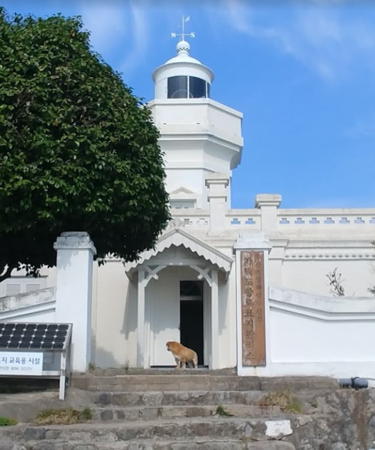
1909 Gadeokdo Light, Gangseo, May 2019
Google Maps photo by Kangkang

Seo-gu (West District) Lighthouses
Dudo (Tudo)
Date unknown. Active; focal plane 54 m (177 ft); white flash every 7 s. 8 m (26 ft) round concrete tower with gallery, painted white. Dong Moon has a distant view of this light (atop the island) and the next one, and Google has a satellite view. Dudo is an island just southeast of the entrance to Gamcheon Harbor (see below). Accessible only by boat. Site status unknown. KR-2039; Admiralty M4355; NGA 16764.
Dudo (Tudo) South
Date unknown. Active; focal plane 18 m (59 ft); two red flashes every 6 s. 18 m (59 ft) round concrete tower with gallery, mounted on a circular concrete pier. Lighthouse painted red. Kwon Tae-jun has a photo, Dong Moon has a distant view of this light (to the right of the island) and the previous one, and Google has a satellite view. Located just off the southwest side of Dudo. Accessible only by boat. Site status unknown. Admiralty M4355.1; NGA 16765.
* Gamcheon (Kamchon) Hang East Breakwater
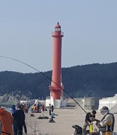
Date unknown. Active; focal plane 32 m (105 ft); two red flashes every 6 s. 30 m (98 ft) round concrete tower with lantern and gallery, painted red. A view down the length of the breakwater is at right, a view from the sea is available, Bosun Chung has a 2020 closeup, and Google has a satellite view. Located at the end of the east breakwater at the harbor entrance. Accessible by walking the pier from Amnam Park. Site open, tower closed. KR-2041; Admiralty M4355.4; NGA 16760.

Saha District Lighthouses
Gamcheon (Kamchon) Hang West Breakwater
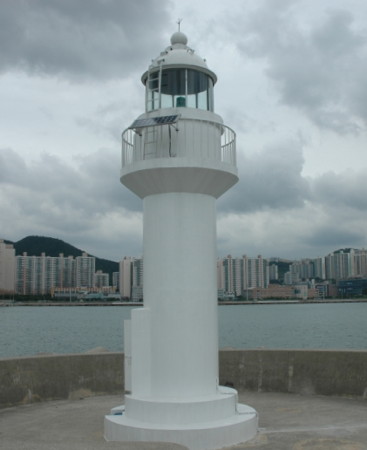
Date unknown. Active; focal plane 32 m (105 ft); two green flashes every 6 s. 30 m (98 ft) round concrete tower with lantern and gallery, painted white. Sungchull Lee has a 2023 closeup photo, this light is to the left of center in Sergey Muravskiy's photo of the harbor entrance, a 2019 photo is available, and Google has a satellite view. Located at the end of the west breakwater at the harbor entrance. Site and tower closed. KR-2042; Admiralty M4355.5; NGA 16760.5.

Gamcheon West Breakwater light, October 2017
Google Maps photo by 이진명
Gamcheon (Kamchon) Hang Outer Breakwater East End
2014. Active; focal plane 23 m (75 ft); two green flashes every 6 s. 18 m (59 ft) square white concrete tower, built in a graceful curve, with lantern and gallery. Moon Ik-cheol has a 2022 photo, this light is at the left in Choi Jun-yeol's photo of the breakwater and to the right of center in Sergey Muravskiy's photo of the harbor entrance, and Google has a satellite view. Gamcheon is a new harbor about 5 km (3 mi) southwest of the South Harbor (Busan Nam Hang). Located at the east end of a short outer breakwater. Accessible only by boat. Site status unknown. KR-2042.1; Admiralty M4355.7; NGA 16768.1.
Gamcheon (Kamchon) Hang Outer Breakwater West End
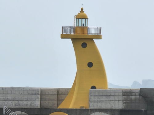
2014. Active; focal plane 19 m (62 ft); two yellow flashes every 6 s. 13 m (43 ft) square yellow concrete tower, built in a graceful curve, with lantern and gallery. Moon Ik-cheol has the 2022 photo seen at right, this light is at the right in Choi Jun-yeol's photo of the breakwater and at the far right in Sergey Muravskiy's photo of the harbor entrance, and Google has a satellite view. Located at the west end of a short outer breakwater. Accessible only by boat. Site status unknown. KR-2042.2; Admiralty M4355.6; NGA 16768.2.
Gamcheon Hang Entrance Range Front
2011. Active; focal plane 106 m (348 ft); continuous green light. 101 m (331 ft) square steel skeletal tower. Google has a street view and a satellite view. This is one of the tallest aids to navigation in the world. The Admiralty renumbered these range lights in 2016. Located in a wharf area on the west side of Gamcheon harbor. Site status unknown. KR 2048; Admiralty M4354.92 (ex-M4354.81); NGA 16763.
 

Gamcheon Outer Breakwater West End Light, Busan, August 2022
Google Maps photo by Moon Ik-cheol
 
Gamcheon Hang Entrance Range Rear
2011. Active; focal plane 162 m (531 ft); continuous green light. 39 m (128 ft) square pyramidal concrete (?) skeletal tower, probably used also as a communications tower. Lighthouse painted with red and white horizontal bands. Google has a satellite view and a distant street view. Located on a ridge northwest of Gamcheon harbor, 775 m (0.48 mi) northwest of the front light. Site status unknown. KR 2049; Admiralty M4354.921 (ex-M4354.82); NGA 16763.5.
Jadam Mal (Doseung, Adeulseom)
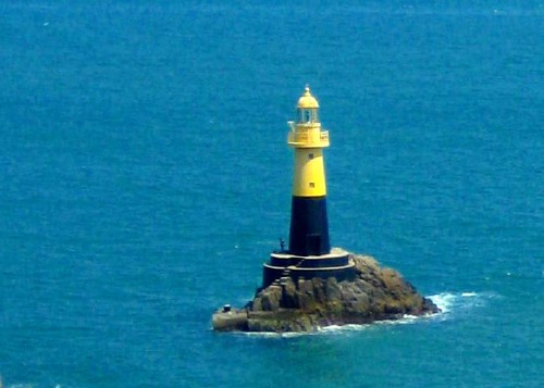
2005. Active; focal plane 19 m (62 ft); six quick white flashes followed by one long white flash every 15 s. 14 m (46 ft) round concrete tower with lantern and gallery; upper half of the lighthouse painted yellow, lower half black. Samuel Orchard's photo is at right, a 2019 closeup is available, the lighthouse is at left in a sunrise photo, and Google has a satellite view. Located on a rock off the end of the Doseung peninsula, about 1.2 km (3/4 mi) southwest of the Gamcheon Hang entrance. Accessible only by boat. Site status unknown. KR-2040; Admiralty M4354.7; NGA 16769.
Songdo
Date unknown. Active; focal plane 20 m (66 ft); red flash every 4 s. 15 m (49 ft) round concrete tower, painted red. The lighthouse is at right in a sunrise photo and Google has a satellite view. Located on a rock about 600 m (3/8 mi) west of the Jadam Mal light, marking the entrance to Dadaepo harbor. Accessible only by boat. Site status unknown. Admiralty M4354.6; NGA 16768.5.
Dadaepo Outer Breakwater
2016. Active; focal plane 17 m (56 ft); red flash every 4 s. 12 m (39 ft) round concrete tower painted red. Heo Jong-yeol has a distant view (red light in the distance) and Google has a satellite view. Located on a breakwater at the east side of the entrance to Dadaepo harbor. Site status unknown. KR-2052.3; Admiralty M4354.55; NGA 16771.8.

Jadam Mal Light, Saha District, May 2008
Wikimedia Creative Commons photo by Samuel Orchard
Dadaepo North Breakwater
Date unknown. Active; focal plane 10 m (33 ft); three red flashes every 8 s. 10 m (33 ft) round concrete tower with lantern and gallery, painted red. Jarn Godfrey has a photo, Choi Jin-ho has a street view, and Google has a satellite view. Located at the end of the L-shaped north breakwater of Dadaepo harbor. Site status unknown. KR-2052; Admiralty M4354.9; NGA 16771.5.
Dadaepo South Breakwater
Date unknown. Active; focal plane 10 m (33 ft); green flash every 10 s. 9 m (30 ft) round concrete tower with lantern and gallery, painted white. A Coast Guard photo is at right, Choi Jin-ho has a distant street view, and Google has a satellite view. Located at the end of the south breakwater of Dadaepo harbor. Site status unknown. KR-2054; Admiralty M4354.8; NGA 16771.
Dadaepo Detached Breakwater East End
2016. Active; focal plane 17 m (56 ft); green flash every 4 s. 10 m (33 ft) round concrete tower painted white. Heo Jong-yeol has a distant view (white light in center) and Google has a satellite view. Located at the east end of a detached breakwater of Dadaepo harbor. Accessible only by boat. Site status unknown. KR-2052.1; Admiralty M4354.53; NGA 16771.6.
Dadaepo Detached Breakwater West End
2016. Active; focal plane 16 m (52 ft); yellow flash every 4 s. 11 m (36 ft) round concrete tower painted yellow. Heo Jong-yeol has a distant view (yellow light in center) and Google has an indistinct satellite view. Located at the west end of a detached breakwater of Dadaepo harbor. Accessible only by boat. Site status unknown. KR-2052.2; Admiralty M4354.54; NGA 16771.7.
Gyeongdo (Kyungdo, Goraeseom)
Date unknown. Active; focal plane 41 m (135 ft); white flash every 5 s. 10 m (33 ft) octagonal concrete tower, painted white. Shin Myung-ho has a 2022 photo, a very distant view is available, Kei Unggaro has a very distant street view from shore, and Google has a satellite view. Located on an island on the west side of the entrance to Dadaepo harbor. Accessible only by boat. Site status unknown. KR-2057; Admiralty M4354.5; NGA 16770.
Molundae (Morundo)
2007. Active; focal plane 16 m (52 ft); two white flashes every 5 s. 15 m (49 ft) round cylindrical concrete tower, painted black with a broad red horizontal band. A distant photo is available, Kei Unggaro has a street view from shore, and Google has a satellite view. Located on a skerry about 2 km (1.2 mi) southwest of the Dadaepo harbor entrance. Accessible only by boat. Site status unknown. KR-2057.1; Admiralty M4354.3.
Dadaepo South Breakwater Light
Dadaepo South Breakwater Light, Saha District
Korean Coast Guard photo (no longer online)
Namuseom East
Date unknown. Active; focal plane 15 m (49 ft); three quick white flashes every 10 s. 12 m (39 ft) round concrete tower painted black with a red horizontal band. A photo is available and Google has an indistinct satellite view. Located on a reef about 700 m (0.45 mi) east of the Namuseom lighthouse (next entry). Accessible only by boat. Site status unknown. KR-2051.1; Admiralty M4353.2; NGA 16772.1.
Namuseom (Mokto, Mokdo)
Date unknown. Active; focal plane 69 m (226 ft); two white flashes every 6 s. 9 m (30 ft) round cylindrical concrete tower, painted white. A closeup 2023 street view is available, the Degree Confluence Project has a very distant view, and Google has a satellite view. Located atop a high island about 8 km (5 mi) south of Gamcheon. Accessible only by boat. Site status unknown. KR-2051; Admiralty M4353.5; NGA 16772.
Seodo (Sodo, So Do)
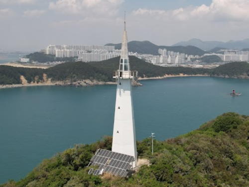
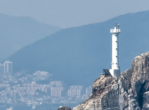
Date unknown. Active; focal plane 119 m (390 ft); white flash every 6 s. 36 m (118 ft) hexagonal white concrete tower with gallery, the tower rising to a very sharp peak. Ilya Lyapin's 2023 drone view is at right, Hyunwook Kim has a distant view, Lee Dong Heon has an extreme closeup, and Google has a satellite view. This light and the next two mark summits of the same mostly-submerged ridge. Located on a high island about 5 km (3 mi) southwest of Gamcheon. Accessible only by boat. Site status unknown. KR-2066; Admiralty M4354; NGA 16768.
Bukhyeongjedo (Pukyongjedo)
2003. Active; focal plane 50 m (164 ft); white flash every 4 s. 19 m (62 ft) round cylindrical concrete tower with lantern and gallery, painted white. Eugene Gladkykh's photo is at right, Chanwoo Seok has a 2022 view from the sea, and Google has a satellite view. The new light was repaired after being damaged by Typhoon Maemi only six months after it was built. Located on a skerry about 15 km (9 mi) southwest of Gamcheon. Accessible only by boat. Site status unknown. KR-2055; Admiralty M4353; NGA 16775.
Namhyeongjedo (Namyongjedo) (2?)
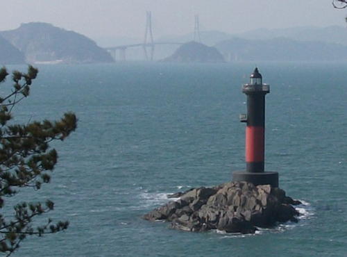
2007 (station establishment date unknown). Active; focal plane 33 m (108 ft); two white flashes every 5 s. Approx. 14 m (46 ft) round barbell-shaped tower painted black with one red horizontal band. Yonghwan Kim has a 2019 photo and Google has a satellite view of the reef. This lighthouse was restored or replaced after being damaged by Typhoon Maemi in September 2003. Located on an islet about 6 km (4 mi) south southwest of the Bukhyeongjedo lighthouse. Accessible only by boat. Site status unknown. KR-2056; Admiralty M4353.7; NGA 16775.5

Gangseo District Lighthouses
Haesu (Nakdong Hang)
Date unknown. Active; focal plane about 10 m (33 ft); yellow light, pattern unknown. 11 m (36 ft) lantern centered on a square 1-story equipment building, mounted on a square platform supported by robust piles. Lighthouse painted yellow with red trim; piles painted red. A very distant street view is available and Google has a satellite view. Located on the east side of the channel entering Nakdong Hang. Accessible only by boat. Site status unknown. Admiralty M4353.92.
* Sinjeoneo Hang South Breakwater
Date unknown. Active; focal plane 10 m (33 ft); red flash every 5 s. 8 m (26 ft) round cylindrical concrete tower with a lower gallery accessed by concrete stairs. Entire lighthouse is red. Google has a street view showing both breakwater lights and a satellite view. Located on the south breakwater of a small boat basin in Nakdong Hang. Accessible by walking the pier. Site open, and visitors can access the lower gallery. KR-2067.95; Admiralty M4353.953; ex-NGA 16773.5.


Seodo Light, Saha District, April 2023
Google Maps photo by Ilya Lyapin

Bukhyeongjedo Light
Bukhyeongjedo Light, Saha District, May 2012
ex-Panoramio Creative Commons photo by Eugene Gladkykh

* Sinjeoneo Hang North Breakwater
Date unknown. Active; focal plane 10 m (33 ft); green flash every 5 s. 8 m (26 ft) round cylindrical concrete tower with a lower gallery accessed by concrete stairs. Entire lighthouse is white. Google has a street view showing both breakwater lights and a satellite view. Located on the north breakwater of a small boat basin in Nakdong Hang. Accessible by walking the pier. Site open, and visitors can access the lower gallery. KR-2067.96; Admiralty M4353.954; ex-NGA 16773.51.
* Daehang (Taehang-ni) East
Date unknown. Active; focal plane 10 m (33 ft); green flash every 5 s. 9 m (30 ft) octagonal cylindrical concrete tower with gallery, painted white. Ryu Hae-chun has a photo, Kei Unggaro has a street view, and Google has a satellite view. Located at the end of the breakwater of a small boat harbor on the east side of the island of Gadeokdo. Accessible by walking the pier. Site open, tower closed. KR-2066.5; Admiralty M4352.5; NGA 16775.7.
** Gadeokdo (Tongdu Mal) (1)
1909. Inactive since 2002. Approx. 14 m (46 ft) octagonal masonry tower attached to a small keeper's house. Entire lighthouse is white. A photo is at the top of this page, Chunwoo Charlie Park has a 2019 closeup, a photo showing both lighthouses is available, the older light can be seen hiding in the middle of the complex in the photo at right, and Google has a satellite view. The keeper's house has been renovated as a meeting and conference center. Located on the southern tip of Gadeokdo, an island about 8 km (5 mi) long about 15 km (9 mi) west southwest of Gamcheon. The site is part of a naval base, so visitors must call to register before visiting the light station. .
** Gadeokdo (Tongdu Mal) (2)
2002 (station established 1909). Active; focal plane 105 m (344 ft); white flash every 12 s. 40.5 m (133 ft) octagonal concrete tower with lantern, gallery, and eight ribs, rising from a 3-story harbor control building. Entire structure painted white. The photo at right is from the Port of Busan's blog, Yun Byeong-yong has a closeup 2018 photo, another photo showing both lighthouses is available, and Google has a satellite view. Located adjacent to the historic lighthouse. ARLHS SKR-043; Admiralty M4352; NGA 16776.
* Daehang (Taehang) North Breakwater South Head
Date unknown. Active; focal plane 14 m (46 ft); green flash every 5 s. 10 m (33 ft) round cylindrical concrete tower with gallery, painted white. Google has a satellite view and a street view showing both breakwater lights. It appears that decorative designs in light blue are painted on the tower. Located at the south end of a T-shaped breakwater at Daehang, on the west side of Gadeokdo. Accessible by walking the pier. Site open, tower closed. KR-2067.3; Admiralty M4352.3; NGA 16779.

Gadeokdo Lights, Gangseo, 2019
Port of Busan photo
* Daehang (Taehang) North Breakwater North Head
Date unknown. Active; focal plane 16 m (52 ft); red flash every 5 s. 12 m (39 ft) round cylindrical concrete tower with gallery, painted red. A 2020 photo is available and Google has a satellite view and a street view showing both breakwater lights. Located at the north end of a T-shaped breakwater at Daehang, on the west side of Gadeokdo. Accessible by walking the pier. Site open, tower closed. KR-2067.1; Admiralty M4352.31; NGA 16779.1.
Gamsuseo (Gabsuseodo)
2007. Active; focal plane 17 m (56 ft); two white flashes every 5 s. 17 m (56 ft) round cylindrical concrete tower with lantern and gallery, painted black with one red horizontal band. Kim Cheol Bong's photo is at right, Google has a satellite view. Located on a reef almost over the east end of the Geoga Tunnel, part of the Busan-Geoje Fixed Link. Accessible only by boat. Site status unknown. KR-2067.12; Admiralty M4351.6.
Daejugdo (Daejukdo, Hodo)
Date unknown. Active; focal plane 19 m (62 ft); white flash every 6 s. 14 m (46 ft) round strongly-conical white stone tower mounted on a robust round concrete pier. Google has a satellite view. Located on an islet southeast of Daejugdo, a small island crossed by the Busan-Geoje Fixed Link in the center of the entrance to Masan Bay (Masan-man). Accessible only by boat. Site status unknown. KR-2075; Admiralty M4351.8; NGA 16778.
Gadeokdo East Breakwater East End (2?)
Date unknown. Active; focal plane 22 m (72 ft); yellow flash every 6 s. 21 m (69 ft) octagonal cylindrical tower, painted yellow. No photo available but Google has a satellite view. Located at the east end of a detached breakwater on the east side of Gadeokdo, north of Daehang. Accessible only by boat. Site status unknown. KR-2071.8; Admiralty M4351.5; NGA 16782.1.
Gadeokdo East Breakwater West End (2)
Date unknown. Active; focal plane 38 m (125 ft); red flash every 4 s. 27 m (89 ft) square concrete tower with lantern and gallery, painted red. The tower sweeps upward in a 1/4-circle arc. No photo available but Google has a satellite view. Located at the west end of the detached breakwater on the east side of Gadeokdo. Accessible only by boat. Site status unknown. KR-2071.7; Admiralty M4351.4; NGA 16782.

Gamsuseo Light, Gangseo, January 2011
Google Maps photo by Kim Cheol Bong

Busan Sin Hang (Busan New Port) Lighthouses
(see also Changwon)
These lights serve new port facilities being developed at the western edge of the Busan municipality. The port itself straddles the line between Busan and the Jinhae District of Changwon, and the approach is through channels mostly within Jinhae.

Horando (Holando)
2006. Active; focal plane 38 m (125 ft); two red flashes every 6 s. 35 m (115 ft) round cylindrical concrete tower with lantern and gallery, painted red. Anthon Anthoniussen has a distant view (red light on the left) and Google has a satellite view. This light and the Todo light (next entry) were about 500 m (0.3 mi) apart; the channel around the north side of Gadeokdo passes between them. Located on a small island off the northwestern side of Gadeokdo. Accessible only by boat. Site status unknown. KR-2072.10; Admiralty M4351.25.
#Todo
2006. Removed in 2018. This was a 35 m (115 ft) round cylindrical concrete tower with lantern and gallery, painted green. Anthon Anthoniussen has a 2008 distant view (green light on the right) and Google has a very distant 2010 street view. Formerly located off the southern tip of a small island off the northwestern side of Gadeokdo. Google's satellite view shows that the entire island has been removed. ex-Admiralty M4351.24.
Busan New Port Multipurpose Terminal (Leading)
Date unknown. Active; focal plane 30 m (98 ft); white, red or green light, depending on direction, occulting once every 6 s. 27 m (89 ft) octagonal white concrete tower. No photo available but Google has a satellite view. Located at the east end of the Busan Sin Hang (Busan New Port) basin. Site and tower closed. Admiralty M4351.255.
Busan New Port Range Front
Date unknown. Active; focal plane 104 m (341 ft); continuous green light. 101 m (331 ft) square skeletal tower. Google has a street view and a satellite view. This range guides ships making the turn into the harbor basin. These range lights are among the tallest navigtional aids in the world. Located on the north side of the harbor facilities. Site and tower closed. Admiralty M4351.26; NGA 16774.1.
Busan New Port Range Rear
Date unknown. Active; focal plane 146 m (479 ft); continuous green light. 101 m (331 ft) square skeletal tower. Google has a street view and a satellite view. Located on a steep hill about 800 m (1/2 mi) northeast of the front light. Site and tower closed. Admiralty M4351.261; NGA 16774.11.

Information available on lost lighthouses:

Notable faux lighthouses:

Adjoining pages: North: Busan Harbor | South: Tsushima | West: Changwon

Return to the Lighthouse Directory index | Ratings key

Posted December 4, 2007. Checked and revised December 11, 2023. Lighthouses: 39. Site copyright 2023 Russ Rowlett and the University of North Carolina at Chapel Hill.