Lighthouses of South Korea: Goseong Bay

For most of its history Korea was an independent kingdom, or at least an autonomous kingdom under Chinese influence. This came to an end in 1910 when Japan annexed all of Korea. At the end of World War II in 1945 the 38° parallel was established as the dividing line between U.S. and Soviet zones of occupation, and in 1948 separate civil administrations were established in the two halves of the country. The Korean War (1950-53) ended in a draw with the armistice line falling close to the prewar 38° line. The Republic of Korea (ROK), commonly called South Korea, occupies the Korean peninsula south of the armistice line.

The name Korea, used internationally, is a Western version of Goryeo or Koryŏ (고려), the name of a kingdom that unified the country in the tenth century. From 1392 to 1897 the kingdom was known instead as Joseon or Chosŏn (조선). Today South Koreans usually call their country Hanguk (한국, literally "one country") and the official name of the Republic of Korea is Daehan Minguk (대한민국).

South Korea is divided into nine provinces and eight province-level cities. The lighthouse on this page are in southwestern Gyeongsangnam (South Gyeongsang) Province on South Korea's south coast. Tongyeong (formerly called Chungmu) is a seaport at the end of the blunt Goseong Peninsula, separated from the island of Namhaedo to the west by the island-strewn waters of Goseong Bay. This page covers the lighthouses of Goseong Bay, including the lighthouses of the Saryang and Yokjim townships of the city of Tongyeong and Goseong County on the north shore of the bay.

In 2000 South Korea adopted a Revised Romanization System to replace systems formerly used in the West. In the Revised System, the word for a lighthouse is deungdae (등대); dan (formerly tan) is a cape, seom (som) or do (to) is an island, am or amseog is a rock, man is a bay, and hang is a harbor. Some place names may be more familiar to Westerners in the spellings of older systems.

Navigational aids in the ROK are operated by the Ministry of Oceans and Fisheries (MOF). Management of lighthouses in Goseong County and Tongyeong is the responsibility of the Masan Regional Oceans and Fisheries Administration.

Special thanks to Kim Cheol Bong for permission to present his photos on this page.

ARLHS numbers are from the ARLHS World List of Lights. KR numbers, where available, are from the Korean light list. Admiralty numbers are from volume M of the Admiralty List of Lights & Fog Signals. U.S. NGA List numbers are from Publication 112.

General Sources
Online List of Lights - Korea
Photos by various photographers posted by Alexander Trabas.
Navionics Charts
Navigational chart information for the Goseong Bay area.
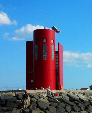

Pogyo Hang Light, Goseong County, October 2014
ex-Panoramio photo copyright Kim Cheol Bong; used by permission
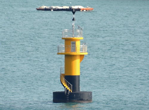
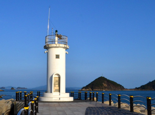
Goseong County Lighthouses

Samsan Township (Northeastern Goseong Bay) Lighthouses
Bangjangyeo
2006. Active; focal plane about 12 m (39 ft); six quick white flashes followed by one long white flash every 15 s. 14 m (46 ft) tower, upper half painted yellow and lower half painted black. Kim Cheol Bong has a photo and Google has a distant satellite view. Located on a reef in the northern portion of the Goseong Bay about 11 km (7 mi) southwest of Goseong city and 1 km (0.6 mi) south of Pogyo, marking the eastern entrance to Jaran Bay. Accessible only by boat. Site open, tower closed. KR-2256.6; Admiralty M4321.545.
Daeseo (Dotumariyeo)
2006. Active; focal plane 10 m (33 ft); two white flashes every 5 s. 12 m (39 ft) tower, painted black with a red horizontal band. This light is on the right in Kim Cheol Bong's photo of the Bangjangyeo Light and Bing has a satellite view. Located on a reef in the northern portion of the Goseong Bay about 12 km (7.5 mi) southwest of Goseong city and 500 m (0.3 mi) south of Pogyo. Accessible only by boat. Site open, tower closed. KR-2235.10; Admiralty M4321.54.
* Pogyo Hang
2006. Active; focal plane 10 m (33 ft); red flash every 4 s. 8 m (26 ft) round cylindrical concrete tower attached to an equipment structure. Lighthouse painted red. Kim Cheol Bong's 2014 photo is at the top of this page, Ellie Choi has a 2022 photo, the lighthouse is near the left edge of Yun Ji Nam's photo of the harbor, and Google has a satellite view. Located at the end of the breakwater at Pogyo on the north shore of Goseong Bay. Accessible by walking the pier. Site open, tower closed. KR-2235.11; Admiralty M4321.538.
Hadaegudo (Hadaehodo, Hadaeho Do)
Date unknown. Active; focal plane 47 m (154 ft); white flash every 6 s. 12 m (39 ft) round concrete tower, painted white. Kim Cheol Bong has a 2021 closeup and a view from the sea and Google has a satellite view. Located on a small island in the northern portion of the bay about 16 km (10 mi) southwest of Goseong city. Accessible only by boat. Site status unknown. Admiralty KR-2236; M4321.55; NGA 16962.
Heukseo
Date unknown. Active; focal plane about 12 m (39 ft); red light, pattern unknown. Approx. 10 m (33 ft) round cylindrical concrete tower with lantern and gallery. Lighthouse painted black with a red horizontal band. No photo available but Google has a satellite view. Located on a reef off Samcheon in the northernmost part of Goseong Bay. Accessible only by boat. Site open, tower closed. Admiralty M4321.53.

Hail Township Lighthouses
Garyoungpo
2014. Active; focal plane 12 m (39 ft); six quick white flashes followed by one long white flash every 15 s. 14 m (46 ft) round concrete tower, upper half painted yellow and lower half painted black. Kim Cheol Bong's photo is at right and Google has a satellite view. Located on a reef in Jaran Bay, off a promontory of the mainland. Accessible only by boat. Site open, tower closed. Admiralty M4321.528.

Garyoungpo Light, Goseong County, February 2016
Google Maps photo by Kim Cheol Bong; used by permission
Jangjinseo (Jaranman, Jalanman) (West)
2011. Active; focal plane 10 m (33 ft); two white flashes every 5 s. 11 m (36 ft) round concrete tower with lantern and gallery, painted black with a red horizontal band. Kim Cheol Bong has a photo and Google has a satellite view. Located on a reef in Jaran Bay, about 1.6 km (1 mi) southeast of Limpo village. Accessible only by boat. Site open, tower closed. Admiralty M4321.525.
Myoseo
Date unknown. Active; focal plane 14 m (46 ft); two white flashes every 5 s. 11 m (36 ft) round concrete tower, painted black with a red horizontal band. No photo available but Google has a satellite view. This light marks a reef in a narrow passage north of Saryangdo. Located on a skerry about 2.5 km (1.5 mi) north of Sangdo. Accessible only by boat. Site open, tower closed. KR-2255; Admiralty M4321.51; ex-NGA 17006.
* Maekjeonpo Hang East (Inner) Breakwater (2)
Date unknown. Active; focal plane 12 m (39 ft); red flash every 6 s. 8.5 m (28 ft) octagonal tower with gallery, painted red. Kim Cheol Bong has a photo, Kang-lyeol Lee has a drone view, and Google has a satellite view. Located at the end of the east (inner) breakwater of Maekjeonpo. Accessible by walking the pier. Site open, tower closed. KR-2252; Admiralty M4321.83; NGA 16963.5.
* Maekjeonpo Hang West (Outer) Breakwater (2)
Date unknown. Active; focal plane 12 m (39 ft); green flash every 6 s. 7 m (23 ft) round white concrete tower with gallery. Kim Cheol Bong's photo is at right, Kang-lyeol Lee has a drone view, and Google has a satellite view. Located at the end of the west (outer) breakwater of Maekjeonpo. Accessible by walking the pier. Site open, tower closed. KR-2251; Admiralty M4321.8; NGA 16963.
Maekjeonpo Outer Breakwater Light
Maekjeonpo Hang West Breakwater Light, Goseong County, April 2012
ex-Panoramio photo copyright Kim Cheol Bong; used by permission

Hai Township Lighthouse
Yulpomal (Yulpo Mal)
Date unknown. Active; focal plane 32 m (105 ft); white flash every 6 s. 5 m (17 ft) round white concrete tower. No photo available but Google has an indistinct satellite view. Located on a headland marking the northern entrance to Sacheon harbor to the west. The lighthouse is within a station of unknown function. Site status unknown. KR-2253; Admiralty M4321; NGA 16964.

Tongyeong City: Saryang Township Lighthouses

The Saryang Township includes a number of islands in the center of Goseong Bay. Hado ("lower island"), the easternmost island, is separated from Sangdo ("upper island") by a narrow channel. The two islands together are often called Saryangdo. The third and smallest of the principal islands, Suudo, is about 3 km (2 mi) to the west southwest of Sangdo. The islands have a permanent population of about 1750.

Suudo Lighthouses
Suudo
Date unknown. Active; focal plane 16 m (52 ft); white flash every 7 s. 10 m (33 ft) round cylindrical white concrete tower with gallery. No photo available but Bing has a satellite view. Located at the western tip of Suudo, an island at the west end of the Saryangdo group. Probably accessible only by boat. Site open, tower closed. KR-2254; Admiralty M4321.4; NGA 17020.
Badayeo
Date unknown. Active; focal plane 15 m (49 ft); two white flashes every 5 s. 16 m (52 ft) tower, painted black with a red horizontal band. Kim Cheol Bong's photo is at right, he also has a view from shore, W.Y. Han has a more distant view, and Google has a satellite view. Located on a reef about 400 m (1/4 mi) off the northern tip of Suudo. Accessible only by boat. Site open, tower closed. KR-2254.1; Admiralty M4321.43.

Sangdo Lighthouses
* Dongji Hang Breakwater
Date unknown. Active; focal plane 9 m (30 ft); green flash every 6 s. 8 m (26 ft) round hourglass-shaped concrete tower, painted white. Kim Cheol Bong has a closeup photo, a distant view is available,and Google has a satellite view. Located on the breakwater of a small fishing harbor on the southwest side of Sangdo. Accessible by walking the pier. Site open, tower closed. KR-2245.1; Admiralty M4321.495; NGA 17008.1.
* Sangdo
Date unknown. Active; focal plane 15 m (49 ft); white flash every 5 s. 10 m (33 ft) round white concrete tower. There's a photo (a little over halfway down the page) in which the light is partially hidden by trees, and Bing has an indistinct satellite view. Located on the northern tip of Sangdo. Site open, tower closed. Admiralty M4321.5; NGA 17008.
* [Jinchong Hang (Geumpyeong)]
Date unknown. Active; focal plane about 12 m (39 ft); green light, pattern unknown. Approx. 7 m (23 ft) post. KIm Cheol Bong has a photo and Google has an indistinct satellite view. Located on the breakwater of a small posrt at the eastern end of Sangdo. Accessible by walking the pier. Site open, tower closed. Admiralty M4321.515.
Badayeo Light
Badayeo Light, Saryang District, June 2013
ex-Panoramio photo by Kim Cheol Bong; used by permission

Hado Lighthouses
Tonggang
Date unknown. Active; focal plane 60 m (197 ft); white flash every 4 s. 7.5 m (25 ft) round white concrete tower. Kim Cheol Bong has a view from the sea, Kang-lyeol Lee has a very distant aerial view, and Google has a satellite view. Located on the northern tip of Hado, marking the northern entrance to the passage between Sangdo and Hado. Site status unknown, but it appears that the light might be accessible from a nearby highway. KR-2256; Admiralty M4321.52; NGA 17008.5.
Baekseo (Paek So)
Date unknown. Active; focal plane 15 m (49 ft); two white flashes every 5 s. 11 m (36 ft) octagonal concrete tower, painted with black and red horizontal bands. No photo available but Bing has a satellite view. Located on a skerry about 3 km (2 mi) southeast of Hado. Accessible only by boat. Site open, tower closed. KR-2248; Admiralty M4322.95; NGA 17016.
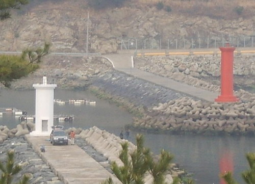
* Yangji Hang (Neunryang) East Breakwater
Date unknown. Active; focal plane 12 m (39 ft); red flash every 6 s. 9.5 m (31 ft) round cylindrical concrete tower, painted red. Kim Cheol Bong has a photo, his photo of both breakwater lights is at right, and Google has a satellite view and a foggy 2023 street view. Located on the east breakwater of a protected harbor on the southeast side of Hado. Accessible by walking the pier. Site open, tower closed. KR-2267; Admiralty M4321.59; NGA 17010.5.
* Yangji Hang (Neunryang) West Breakwater
Date unknown. Active; focal plane 10 m (33 ft); green flash every 6 s. 7.5 m (25 ft) round cylindrical concrete tower, painted white. Kim Cheol Bong has a closeup photo, his photo of both breakwater lights is at right and Google has a satellite view. Located on the west breakwater of a protected harbor on the southeast side of Hado. Accessible by walking the pier. Site open, tower closed. KR-2268; Admiralty M4321.58; NGA 17010.
Nammudo
Date unknown. Active; focal plane 19 m (62 ft); quick-flashing white light. 17 m (56 ft) tower. The upper half of the tower is painted black, lower half yellow. Kim Cheol Bong has a closeup 2013 photo; at that time the tower was painted black with one red horizontal band. Google has a satellite view. Located on a rock about 4 km (2.5 mi) south southwest of Hado. Accessible only by boat. Site status unknown. KR-2266; Admiralty M4321.47; NGA 17013.
Yangji Hang Breakwater Lights
Yangji Hang West (left) and East Breakwater Lights, Saryangdo, January 2011
ex-Panoramio photo copyright Kim Cheol Bong; used by permission
Mokseokdo (Moksokto)
Date unknown. Active; focal plane 19 m (62 ft); red flash every 4 s. 10 m (33 ft) octagonal concrete tower, painted red. Kim Cheol Bong has a photo and Google has a satellite view. Located on a small island off the southwest corner of Hado, marking the southern entrance to the passage between Sangdo and Hado. Accessible only by boat. Site status unknown. KR-2249; Admiralty M4321.45; NGA 17012.
Hoseong
Date unknown. Active; focal plane 6 m (20 ft); red flash every 4 s. 10 m (33 ft) round red concrete tower. No photo available but Google has a satellite view. Located on a shoal just south of the village of Eupdeok on the west coast of Hado. Accessible only by boat. Site open, tower closed. KR-2246; Admiralty M4321.513.
 

Tongyeong City: Yokjim Township Lighthouses

The Yokjim Township includes a scattering of rather small islands across the entrance to Goseong Bay from the Korea Strait. Yogjido is by far the largest of the islands. The permanent population of the district is about 2300.

Dumido Lighthouse
Dumido (Tumido)
Date unknown. Active; focal plane 21 m (69 ft); white flash every 6 s. 12 m (39 ft) round cylindrical white concrete tower. Kim Cheol Bong has a closeup photo and a very distant view and Bing has an indistinct satellite view. Located on the northwest coast of Dumido, an island about 10 km (6 mi) northwest of Yogjido, 30 km (19 mi) southwest of Tongyeong and a similar distance southeast of Namhae. Site open, tower closed. KR-2241.2; Admiralty M4322.37.

Nodae Area Lighthouses
Nodae is the largest of a group of islands about 8 km (5 mi) north of Yogjido.

Saidoyeo
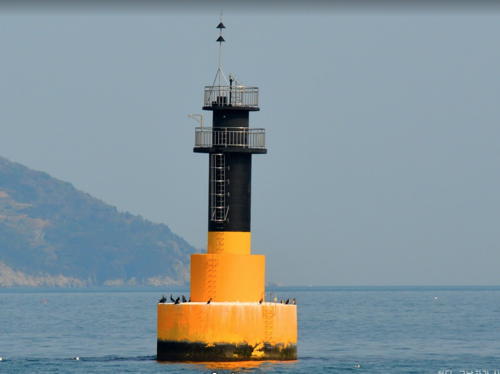
Date unknown. Active; focal plane 12 m (39 ft); quick-flashing white light. 16 m (52 ft) round concrete tower, painted yellow with a black band at the top. Kim Cheol Bong has a closeup photo (also seen at right) and Google has a satellite view. Located on a shoal east of Nodae and about 5 km (3 mi) north of Yogjido. Accessible only by boat. Site open, tower closed. KR-2237.7; Admiralty M4322.45.
Kachiyeo
2012. Active; focal plane about 16 m (52 ft); light characteristic unknown. Approx. 16 m (56 ft) round concrete tower, painted black with a red horizontal band. Kim Cheol Bong has a photo and Google has a satellite view. Located on a reef off the northeastern tip of Nodae. Accessible only by boat. Site open, tower closed. KR-2237.1; Admiralty M4322.44.
Haseo
2012. Active; focal plane 16 m (52 ft); two white flashes every 10 s. 20 m (66 ft) round concrete tower, painted black with a red horizontal band. Kim Cheol Bong has a distant view and Google has a satellite view. Located on a reef about 5 km (3 mi) northeast of Nodae. Accessible only by boat. Site open, tower closed. KR-2237.2; Admiralty M4322.43.
Gyoboncho (Kyobon-cho)
2001. Active; focal plane 14 m (46 ft); two white flashes every 5 s. 14 m (46 ft) tower, painted black with one red horizontal band. Kim Cheol Bong has a photo and Bing has a satellite view. The red band has faded away in Kim's photo. Located on a shoal in the bay about 10 km (6 mi) northeast of Nodae. Accessible only by boat. Site open, tower closed. KR-2237.5; Admiralty M4322.71; NGA 16953.5.

Saidoyeo Light,Yokjim Township, May 2014
Google Maps photo by Kim Cheol Bong; used by permission
Yogjido Area Lighthouses
Yogjido is an irregularly shaped island about 5 km (3 mi) long by 3 km (2 mi) wide about 30 km (19 mi) southwest of Tongyeong.
Heukcho
2002(?). Active; focal plane 14 m (46 ft); two white flashes every 5 s. 14 m (46 ft) tower, painted black with one red horizontal band. Yeong Cheol has a 2020 photo and Google has a satellite view. Located on a shoal off the south side of Yogjido. Accessible only by boat. Site open, tower closed. KR-2241.3; Admiralty M4322.42; NGA 16961.
Heukcho South
2021. Active; focal plane 58 m (186 ft); four yellow flashes every 8 s. 58 m (186 ft) triangular tower. No photo available and the light is too new to appear in Bing's satellite view. Announced by the Admiralty in Septenber 2021, the function of this tower is unknown. Located about 6 km (3.5 mi) south of the Heukcho Light. KR-2241.5; Admiralty M4322.41.
Yogjido (Yogji Do, Yokji Do) (2?)
Date unknown (station established 1961). Active; focal plane 195 m (640 ft); white flash every 6 s. 13 m (43 ft) round cylindrical concrete tower with lantern and gallery. Entire lighthouse is white. Kim Cheol Bong has a very distant view and Google has a satellite view. Located on a mountainous peninsula on the southwest side of Yogjido Site status unknown. KR-2241; Admiralty M4322.4; NGA 16960.
* Yogjido West Breakwater
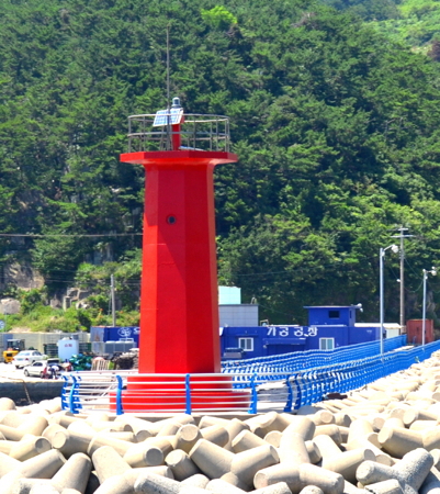
Date unknown. Active; focal plane 14 m (46 ft); red flash every 4 s. 8 m (26 ft) octagonal concrete tower. Entire lighthouse is red. Kim Cheol Bong's 2013 photo is at right, he also has a 2018 photo, Seongwoo Kim has a 2022 photo, and Google has a satellite view. Located at the end of the breakwater on the northwest side of the harbor of Yogjido, on the northeast side of the island. Accessible by walking the pier. Site open, tower closed. KR-2239; Admiralty M4322.6; NGA 16956.
* Yogjido South Breakwater
Date unknown. Active; focal plane 11 m (36 ft); two yellow flashes every 6 s. 8 m (26 ft) octagonal concrete tower. Entire lighthouse is yellow. Kim Cheol Bong has a photo, I.M. Sangbin has a photo, and Google has a satellite view. Located at the end of the breakwater on the south side of the harbor of Yogjido. Accessible by walking the pier. Site open, tower closed. KR-2240; Admiralty M4322.65; NGA 16956.5.
* Yogjido East Breakwater
Date unknown. Active; focal plane 12 m (39 ft); green flash every 4 s. 8 m (26 ft) octagonal concrete tower. Entire lighthouse is white. Kim Cheol Bong has a photo, I.M. Sangbin has a distant photo, and Google has a satellite view. Located at the end of the breakwater on the east side of the harbor of Yogjido. Accessible by walking the pier. Site open, tower closed. KR-2238; Admiralty M4322.62; NGA 16956.3.

Yogjido West Breakwater Light, Yogjido, July 2013
ex-Panoramio photo copyright Kim Cheol Bong; used by permission
Yeonhwado Area Lighthouses
Yeonhwado is a smaller island lying northeast of Yokjido. The island is a tourist attraction, famous as the site of a historic Buddhist temple.
Bongdo (Bong Do)
Date unknown. Active; focal plane 107 m (351 ft); white flash every 6 s. 11 m (36 ft) round cylindrical white concrete tower. The light is barely visible in Kim Cheol Bong's distant view of the island; Google has a satellite view. Located on the highest point of a small island about 5 km (3 mi) northwest of Yeonhwado. Site status unknown. Admiralty M4322.5; NGA 16954.
Useo
2006. Active; focal plane 22 m (72 ft); two white flashes every 5 s. 10 m (33 ft) tower, painted black with one red horizontal band. Kim Cheol Bong has a photo and Bing has a satellite view. Located on an islet about 3 km (2 mi) north of Yeonhwado. Accessible only by boat. Site status unknown. KR-2234.5; Admiralty M4322.52.
Napjangnyeo (Napjakyeo)
2003(?). Active; focal plane 13 m (43 ft); two white flashes every 5 s. 14 m (46 ft) tower, painted black with one red horizontal band. Kim Cheol Bong has a closeup photo and Google has a satellite view. Located on a shoal off the northwest coast of Yeonhwado . Accessible only by boat. Site open, tower closed. KR-2241.4; Admiralty M4322.55; NGA 16958.
Yeonhwa Hang
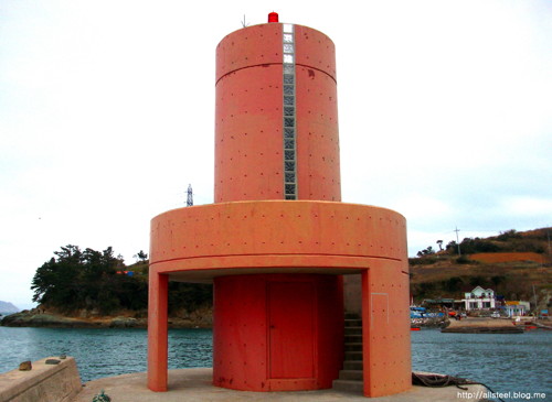
2007. Active; focal plane 10 m (33 ft); red flash every 4 s. 8 m (26 ft) round cylindrical tower; the lower portion of the tower is surrounded by a round observation platform. Entire lighthouse is red. Kim Cheol Bong's photo is at right, he also has a view across the harbor, and Google has a satellite view. Located on the breakwater of Yeonhwado harbor. Accessible by walking the pier. Site open, and visitors can climb an external stairway to the observation platform. KR-2247.1; Admiralty M4322.54.
Yeonhwado Light
Yeonhwa Hang Light, Yeonhwado, December 2012
ex-Panoramio photo copyright Kim Cheol Bong; used by permission
Jwasarido Area Lighthouses
These lighthouses mark the ends of a dangerous reef system in the Korea Strait about 9 km (15 mi) south of Yeonhwado.
Oejangdeogam
Date unknown. Active; focal plane 18 m (59 ft); two white flashes every 5 s. 12 m (39 ft) tower, painted black with one red horizontal band. No photo available but Bing has a satellite view. Located on a rocky islet about 5 km (3 mi) south of Yeonhwado. Accessible only by boat. Site open, tower closed. KR-2235.5; Admiralty M4322.703.
Jwasarido (Chwarasido, Chwasari Do) (2)
2007 (station established 1983). Active; focal plane 58 m (190 ft); white flash every 4 s. 13 m (43 ft) octagonal concrete tower with a gallery framed by eight ribs. Entire lighthouse is white. A view from the sea is available and Google has a satellite view. Located on an island about 35 km (22 mi) south of Tongyeong. Accessible only by boat. Site open, tower closed. KR-2235; Admiralty M4322.7; NGA 16868.

Gukdo and Goamdo Lighthouses
Gukdo
2018. Active; focal plane 227 m (745 ft); white flash every 5 s. 9 m (30 ft) round white concrete tower with lantern and gallery centered on a rectangular building. The roof of the building and the dome of the lighthouse are painted so that from the air they display an image of the flag of South Korea. No photo available but Bing has an indistinct satellite view. Located on the highest point of Gukdo, an island about 10 km (6 mi) southeast of Yeonhwado. Site status unknown. KR-2217.6; Admiralty M4332.8.
Goam (Koam, Go Am Island)
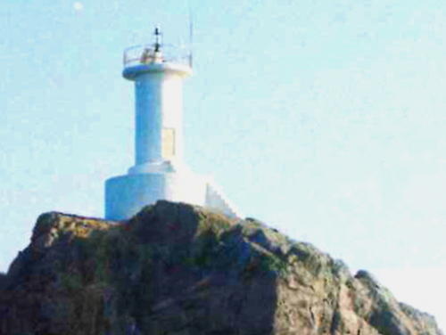
Date unknown. Active; focal plane 31 m (102 ft); white flash every 6 s. 14 m (46 ft) octagonal white concrete tower. Kim Cheol Bong has a photo and Bing has a satellite view. Goamdo is an island about 2 km (1.25 mi) in length located far out into the Korea Strait, about 15 km (9 mi) south southwest of Somaemuldo. Located on the highest point of the island. Accessible only by boat. Site status unknown. KR-2173; Admiralty M4333; NGA 16874.

Goam Light, Yokjim, July 2013
ex-Panoramio photo copyright Kim Cheol Bong; used by permission
Information available on lost lighthouses:

Notable faux lighthouses:

Adjoining pages: East: Tongyeong | Southwest: Namhae | Northwest: Sacheon

Return to the Lighthouse Directory index | Ratings key

Posted December 4, 2007. Checked and revised January 21, 2024. Lighthouses: 41. Site copyright 2024 Russ Rowlett and the University of North Carolina at Chapel Hill.