Lighthouses of South Korea: Tongyeong

For most of its history Korea was an independent kingdom, or at least an autonomous kingdom under Chinese influence. This came to an end in 1910 when Japan annexed all of Korea. At the end of World War II in 1945 the 38° parallel was established as the dividing line between U.S. and Soviet zones of occupation, and in 1948 separate civil administrations were established in the two halves of the country. The Korean War (1950-53) ended in a draw with the armistice line falling close to the prewar 38° line. The Republic of Korea (ROK), commonly called South Korea, occupies the Korean peninsula south of the armistice line.

The name Korea, used internationally, is a Western version of Goryeo or Koryŏ (고려), the name of a kingdom that unified the country in the tenth century. From 1392 to 1897 the kingdom was known instead as Joseon or Chosŏn (조선). Today South Koreans usually call their country Hanguk (한국, literally "one country") and the official name of the Republic of Korea is Daehan Minguk (대한민국).

South Korea is divided into nine provinces and eight province-level cities. This page covers lighthouses in the city of Tongyeong in southwestern Gyeongsangnam (South Gyeongsang) province on South Korea's south coast. Tongyeong (formerly called Chungmu) is a seaport at the end of the blunt Goseong Peninsula, separated from the island of Geojedo to the east by the island-strewn waters of Goeje Bay and from the island of Namhaedo to the west by the island-strewn waters of Goseong Bay.

Tongyeong administers many islands south of the urban area and extending into the Korea Strait. This broad area includes close to 100 lighthouses. There is a page for lighthouses of the Hansan township to the southeast and the Goseong Bay page includes lighthouses of the Saryang and Yokjim townships to the southwest.

Navigational aids in the ROK are regulated by the Ministry of Oceans and Fisheries (MOF). Management of lighthouses in Tongyeong is the responsibility of the Masan Regional Maritime Affairs and Port Office. The Korean Hydrographic and Oceanographic Administration (KHOA) publishes notices to mariners.

In 2000 South Korea adopted a Revised Romanization System to replace systems formerly used in the West. In the Revised System, the word for a lighthouse is deungdae (등대); dan (formerly tan) is a cape, seom (som) or do (to) is an island, am or amseog is a rock, man is a bay, and hang is a harbor. Some place names may be more familiar to Westerners in the spellings of older systems.

Special thanks to Kim Cheol Bong for permission to present his photos on this page.

ARLHS numbers are from the ARLHS World List of Lights. KR numbers, where available, are from the Korean light list. Admiralty numbers are from volume M of the Admiralty List of Lights & Fog Signals. U.S. NGA List numbers are from Publication 112.

General Sources
Online List of Lights - Korea
Photos by various photographers posted by Alexander Trabas.
Lighthouses to Visit
Information on three lighthouses provided by the Masan Office of Oceans and Fisheries.
Navionics Charts
Navigational chart for the Tongyeong area.
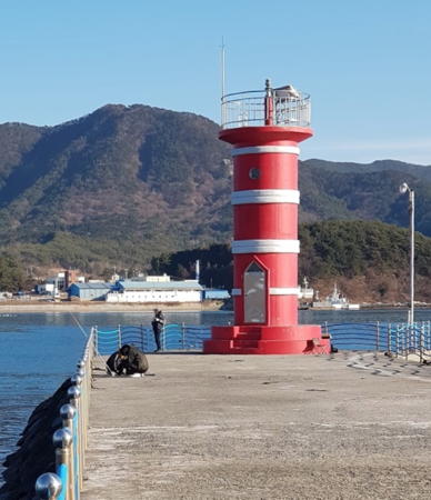

Haegan Hang Light, Tongyeong, January 2019
Google Maps photo by Kwang Rae Cho
Eastern Goseong County Lighthouse

For other lighthouses of Goseong County, see the Goseong Bay page.

Hoehwa Township Lighthouse
Danghangpo (Donghang)
Date unknown. Active; focal plane 10 m (33 ft); two white flashes every 5 s. 11 m (33 ft) octagonal cylindrical concrete tower with gallery, mounted on a round concrete pier. Lighthouse painted black with a broad red horizontal band. Kim Cheol Bong has a closeup photo, HoonSik Jung has a distant view, and Google has a satellite view. Located on a reef just off Donghang harbor, on the east side of Goseong County north of Tongyeong. Accessible only by boat. Site open, tower closed. KR-2036.6; Admiralty M4340.995.

Georyu Township Lighthouse
* Dangdong Hang
Date unknown. Active; focal plane about 14 m (46 ft); red light, pattern unknown. Approx. 10 m (33 ft) round red concrete tower. Kim Cheol Bong has a closeup photo and Google has a satellite view. Located on the pier at Dangdong village. Accessible by walking the pier. Site open, tower closed. Admiralty M4340.974.

Northern Tongyeong Lighthouses

Gwangdo Township (Northern Tongyeong) Lighthouses
Anjeong Hang
Date unknown. Active; focal plane 15 m (49 ft); red flash every 6 s. 11 m (36 ft) round cylindrical concrete tower with lantern and gallery, painted red. No closeup photo available but Google has a satellite view. The lighthouse is visible just left of center in Kim Cheol Bong's distant view of the harbor. Located on a breakwater pier at the giant Sungdong shipyard on the east side of the Goseong peninsula in the northeastern corner of Tongyeong. Site and tower closed. KR-2217.1; Admiralty M4340.975; NGA 16931.
* Yepo Hang
Date unknown. Active; focal plane 11 m (36 ft); green flash every 4 s. 8.5 m (36 ft) round cylindrical concrete tower, painted white. A photo is available and Google has a satellite view. Located on a pier of the Yepo fishing harbor, just south of the Sungdong shipyard. Accessible by walking the pier. Site open, tower closed. KR-2218.2; Admiralty M4340.973; NGA 16929.9.
Kojedo
Date unknown. Active; focal plane 10 m (33 ft); two white flashes every 5 s. 10 m (33 ft) round cylindrical concrete tower with lantern and gallery, painted black with one red horizontal band. A very distant view (lighthouse right of center) is available but Google has an indistinct satellite view. The Admiralty lists this light as Anjeong Hang Approach. Located about 2 km (1.25 mi) east of Yepo Hang. Accessible only by boat. Site open, tower closed. KR-2204; Admiralty M4340.97; NGA 16930.

Yongnam Township (Northeastern Tongyeong) Lighthouses
Gamuyeo (Gamuseo)
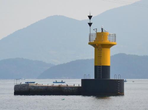
Date unknown. Active; focal plane 9.5 m (31 ft); six quick white flashes followed by one long white flash every 15 s. 11 m (36 ft) round cylindrical concrete tower, upper half painted yellow, lower half black. Kim Cheol Bong has the photo at right and Google has a satellite view. Located in the channel between the island of Jido and the mainland. Accessible only by boat. Site open, tower closed. KR-2207; Admiralty M4329.2; NGA 16933.
* Gyeonyu Hang East Breakwater
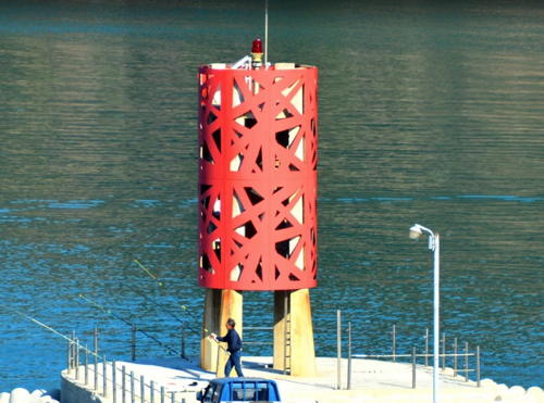
Date unknown. Active; focal plane 9 m (30 ft); red flash every 6 s. Approx. 10 m (33 ft) round hourglass-shaped concrete tower. Entire lighthouse is red. Kim Cheol Bong has a photo, Dong Kim has a 2021 closeup, and Google has a satellite view. Located at the end of the Gyeongyu east breakwater. Accessible by walking the pier. Site open, tower closed. KR-2210; Admiralty M4328.2.
* Gyeonyu Hang South Breakwater
Date unknown. Active; focal plane 9 m (30 ft); green flash every 6 s. Approx. 10 m (33 ft) round hourglass-shaped concrete tower. Entire lighthouse is white. Bong-hee Lee has a photo and Google has a satellite view. Located at the end of the Gyeongyu south breakwater. Accessible by walking the pier. Site open, tower closed. KR-2209; Admiralty M4328.1.
Gyeonnaeryang (Kyonnaeryang)
Date unknown. Active; focal plane 12 m (39 ft); green flash every 4 s. 10 m (33 ft) round cylindrical concrete tower, painted green. A view is available, the light is seen under the Geoje Bridge at far left in a distant view and a second distant view and Google has a satellite view. Located in the narrow channel between Geoje and Tongyeong, about 5 km (3 mi) northeast of Tongyeong city. Accessible only by boat. Site open, tower closed. KR-2206; Admiralty M4328; NGA 16936.

Gamuyeo Light, Tongyeong, November 2013
Google Maps photo by Kim Cheol Bong
* Yeongi Hang
2016. Active; focal plane 12 m (39 ft); red flash every 5 s. 7 m (23 ft) round concrete tower painted red with white trim. Youngdeuk Jo has a 2022 closeup photo, Eom Dong Hyun has a photo, and Google has a satellite view. Located on the north breakwater of a small boat harbor on the east side of Tongyeong. Accessible by walking the pier. Site open, tower closed. Admiralty M4327.3.
* Haegan Hang
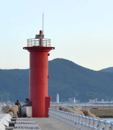
2016. Active; focal plane 12 m (39 ft); red flash every 5 s. 8 m (26 ft) round concrete tower painted red with white trim. Kwang Rae Cho has a photo (also seen at the top of this page), Donghyun Lee also has a photo, and Google has a satellite view. Located on the north breakwater of a small boat harbor on the east side of Tongyeong. Accessible by walking the pier. Site open, tower closed. KR-2212.2; Admiralty M4327.2.

Tongyeong Harbor North Side Lighthouses
Tongyeong Harbor is the narrow strait separating the mainland (the south end of the Goseong Peninsula) from Mireuk Island.There are harbor facilities on both sides of the strait.
Saseo (Sado, Saso)
Date unknown. Active; focal plane 18 m (56 ft); white flash every 6 s. 10 m (33 ft) round cylindrical concrete tower with gallery, painted white. Kim Cheol Bong has a photo and Google has a satellite view. Located on an island in northern Geoje Bay about 2.5 km (1.5 mi) northeast of the entrance to Tongyeong harbor. Accessible only by boat. Site open, tower closed. KR-2214; Admiralty M4327; NGA 16928.
Daeseokseo
Date unknown. Active; focal plane 10 m (33 ft); three quick white flashes every 10 s. 10 m (33 ft) round cylindrical concrete tower with gallery, painted black with one yellow horizontal band. Seonghan Park has a distant 2022 view, Kyungim Kim also has distant view, and Bing has a satellite view. Located on a shoal off a pier southwest of Saseo. Accessible only by boat. Site open, tower closed. KR-2216.4; Admiralty M4326.6; NGA 16928.5.
Tongyeong (Chungmu) Approach (Jinhaeseo)
Date unknown. Active; focal plane 15 m (49 ft); green flash every 5 s. 11 m (36 ft) round hourglass-shaped concrete tower with gallery, painted green. The light is near the right edge of Seo Ji-young's distant view and Google has a satellite view. Located on a reef about 1 km (0.6 mi) northeast of the Tongyeong harbor entrance. Accessible only by boat. Site open, tower closed. KR-2217; Admiralty M4326.3; NGA 16929.
Dongho Hang North Breakwater
Date unknown. Active; focal plane 13 m (43 ft); red flash every 4 s. 10 m (33 ft) round cylindrical concrete tower with gallery, painted red. Kim Cheol Bong's photo is at right, Sanghong Park has a distant view, and Google has a satellite view. Located at the end of the short north breakwater of Tongyeong's traditional harbor. Site status unknown. KR-2226; Admiralty M4325.9; NGA 16918.
Dongho Hang South Breakwater
Date unknown. Active; focal plane 13 m (43 ft); green flash every 4 s. 10 m (33 ft) round cylindrical concrete tower with gallery, painted white. This light is at the left in Kim Cheol Bong's photo and Google has a satellite view. Located at the end of the south breakwater of Tongyeong's traditional harbor. Site status unknown. KR-2225; Admiralty M4325.85; NGA 16918.5.
Jangseo
Date unknown. Active; focal plane 12 m (39 ft); six quick white flashes and one longer white flash every 15 s. 13 m (43 ft) round cylindrical concrete tower with double gallery; upper portion of the tower painted yellow, lower portion black. Kim Cheol Bong has a photo and Google has a satellite view. Located just offshore and west of the entrance to Tongyeong's traditional harbor. Accessible only by boat. Site status unknown. KR-2218; Admiralty M4326.5; NGA 16916.
Tongyeong North Breakwater Light
Tongyeong North Breakwater Light, Tongyeong, August 2011
ex-Panoramio photo copyright Kim Cheol Bong; used by permission
* Dongho-dong Breakwater
Date unknown. Active; focal plane 12 m (39 ft); red flash every 5 s. 7 m (23 ft) round cylindrical red concrete tower. Kim Cheol Bong has a photo and Google has a satellite view. Located on a quay on the Tongyeong waterfront. Accessible by walking the pier. Site open, tower closed. KR-2222.5; Admiralty M4326.55; NGA 16919.
Tongyeong Beacon #7
Date unknown. Active; focal plane 8 m (26 ft); green flash every 5 s. 16 m (52 ft) round green concrete tower. Kim Myung-nim has a view from the waterfront, a photo of beacons 7 and 8 is available, Jeasung Park has a drone view of the two lights, and Google has a satellite view. This light and its companion Beacon #8 bracket the channel about 2.5 km (1.5 mi) west of the Donam Hang lights. Accessible only by boat. Site and tower closed. KR-2227; Admiralty M4323.6; NGA 16920.
Tongyeong Beacon #8
Date unknown. Active; focal plane 8 m (26 ft); red flash every 5 s. 14 m (46 ft) round red concrete tower. Kim Cheol Bong's photo is at right and Google has a satellite view. Accessible only by boat. Site and tower closed. KR-2228; Admiralty M4323.8; NGA 16924.
* Pyeongnim Hang West Breakwater
Date unknown. Active; focal plane 14 m (46 ft); red flash every 6 s. 10 m (33 ft) round red concrete tower. Kim Cheol Bong has a closeup photo and a photo of both breakwater lighthouses and Google has a satellite view. Located at the end of the west breakwater of a small boat harbor on the northwest side of Tongyeong. Accessible by walking the pier. Site open, tower closed. KR-2230.3; Admiralty M4323.055; NGA 16953.
* Pyeongnim Hang East Breakwater
Date unknown. Active; focal plane 14 m (46 ft); flash every 6 s. 10 m (33 ft) round white concrete tower. A 2021 photo is available, this light is on the right in Kim Cheol Bong's 2018 photo, and Google has a satellite view. Located at the end of the east breakwater of a small boat harbor on the northwest side of Tongyeong. Accessible by walking the pier. Site open, tower closedn. KR-2230.4; Admiralty M4323.06.

Beacon #8, Tongyeong, May 2013
Google Maps photo by Kim Cheol Bong
Dongdo (Pildo, Pil To)
Date unknown. Active; focal plane 13 m (43 ft); white flash every 4 s. 9 m (30 ft) round cylindrical white concrete tower with gallery. Kim Cheol Bong has aa 2012 photo and a small 2018 photo and Google has a satellite view. Located on the west end of an island about 5 km (3 mi) west of Pyeongnim Hang. Accessible only by boat. Site open, tower closed. KR-2232; Admiralty M4323; NGA 16952.

Dosan Township (Northwestern Tongyeong) Lighthouse
Sangyangji
2016. Active; focal plane 18 m (59 ft); green flash every 5 s. 18 m (59 ft) round green concrete tower on a round pier. A 2021 photo is available and Google has a satellite view. Located on the west side of the entrance to the harbor of Yangji. Accessible only by boat. Site open, tower closed. KR-2230.2; Admiralty M4323.02.

Mireuk Island and Southern Islands Lighthouses

Mireuk Island (Mireukdo) is a mountainous island roughly 10 km (6 mi) in diameter, with a long, ragged peninsula pointing off its northwestern side into Goseong Bay. The island is separated from the southern tip of the Goseong Peninsula by the narrow strait of Tongyeong Harbor.

Tongyeong Harbor South Side Lighthouses
Sirammal (Shirammal)
Date unknown. Active; focal plane 17 m (56 ft); white flash every 6 s. 11 m (36 ft) square concrete tower, painted white. A very distant view (across the bay on the left, behind the small island) is available but the light is not seen in Bing's satellite view. Located on a promontory on the south side of the approach to Tongyeong harbor from the west. Site status unknown. Admiralty M4323.1; NGA 16942.
* Yultongyeongunha (Misu Hang)
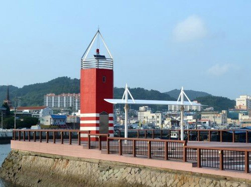
2011. Active; focal plane about 10 m (33 ft); red light, characteristic unknown. Approx. 8 m (26 ft) octagonal cylindrical concrete tower, painted red with four narrow white bands near the base. Kim Cheol Bong's photo is at right, Inho Lee has a closeup photo, and Google has a satellite view. Located on a pier on the south side of Tongyeong harbor about 150 m (165 ft) east of the Tongyeong Bridge. Accessible by walking the pier. Site open, tower closed. KR-2229.2; Admiralty M4323.5.
Donam (Tonam) Hang Central Breakwater West End
Date unknown. Active; focal plane 10 m (33 ft); four green flashes every 8 s. 9 m (30 ft) round cylindrical concrete tower, painted white. Dmitriy Naroditskiy has a photo of the breakwater and both lighthouses, a view from shore is available, and Google has a satellite view. Donam Hang is a basin on the south side of Tongyeong harbor. Located at the east end of a detached breakwater a short distance west of the West Breakwater Light (see below). Accessible only by boat. Site and tower closed. KR-2222.4; Admiralty M4325.62.
Donam (Tonam) Hang Central Breakwater East End
Date unknown. Active; focal plane 10 m (33 ft); four red flashes every 8 s. 9 m (30 ft) square cylindrical concrete tower, painted red. Dmitriy Naroditskiy has a photo of the breakwater and both lighthouses and Google has a satellite view. Located at the east end of a detached breakwater a short distance west of the West Breakwater Light (next entry). Accessible only by boat. Site and tower closed. KR-2222.3; Admiralty M4325.6.

Yultongyeongunha Light, Tongyeong, April 2018
ex-Google Plus photo copyright Kim Cheol Bong; used by permission
Donam (Tonam) Hang West Breakwater
Date unknown. Active; focal plane 12 m (39 ft); two red flashes every 6 s. 8 m (26 ft) octagonal cylindrical concrete tower with gallery, painted yellow. Kim Cheol Bong has a photo (also showing the Jangseo lighthouse in the background) and Google has a satellite view and a very distant street view. Located at the end of the west breakwater at Tonam Hang. Site status unknown. KR-2222; Admiralty M4325.55; NGA 16915.5.
Donam (Tonam) Hang Detached Breakwater West Head
Date unknown. Active; focal plane 12 m (39 ft); two green flashes every 6 s. 8 m (26 ft) octagonal cylindrical concrete tower with gallery, painted white. Kim Cheol Bong has a photo of the breakwater and its two lighthouses, and Google has a satellite view as well as a street view of the two breakwater lights. Located at the west end of a detached breakwater sheltering Tonam Hang. Accessible only by boat. Site and tower closed. KR-2224; Admiralty M4325.8; NGA 16915.
Donam (Tonam) Hang Detached Breakwater East Head
Date unknown. Active; focal plane 12 m (39 ft); red flash every 4 s. 8 m (26 ft) octagonal cylindrical concrete tower with gallery, painted red. Kim Cheol Bong has a photo of the breakwater and its two lighthouses, and Google has a street view and a satellite view. Located at the east end of a detached breakwater sheltering Tonam Hang. Accessible only by boat. Site and tower closed. KR-2223; Admiralty M4325.7; NGA 16914.
* Donam (Tonam) Hang East Breakwater ("Pencil Lighthouse") (2)
1986. Active; focal plane 19 m (62 ft); green flash every 4 s. 17 m (56 ft) round white concrete tower with a conical top; the light is shown from a pyramidal lens at the tip of the tower. The tower is covered with reflective panels. Kim Cheol Bong's photo is at right, Aiden Park has a photo, Chae Pilsu has a photo, and Google has a satellite view and a closeup street view. The original lighthouse was 6 m (20 ft) tall. Located at the end of the east breakwater at Tonam Hang. Accessible by walking the pier. Site status unknown. KR-2221; Admiralty M4325.5; NGA 16915.7.

Donam Hang East Breakwater ("Pencil") Light, April 2018
ex-Google Plus photo copyright Kim Cheol Bong; used by permission

Sanyang Town: Mireuk Island East Coast Lighthouses
* Sanseo
Date unknown. Active; focal plane about 15 m (49 ft); green light, pattern unknown. Approx. 15 m (49 ft) round hourglass-shaped green concrete tower. Kim Cheol Bong has a 2015 closeup photo and Google has a satellite view. Since 2015 a pier or walkway has been extended to the lighthouse. Located on a shoal off a pierhead on the northeast coast of Mireuk Island. Probably accessible by walking the pier. Site open, tower closed. KR-2199; Admiralty M4325.2.
* Iun Hang
Date unknown. Active; focal plane 12 m (39 ft); green flash every 4 s. 8 m (26 ft) round cylindrical concrete tower with gallery. Entire lighthouse is white. Kim Cheol Bong has a photo, Jootae Jeong has a 2017 view from the sea, Jeong Seung-il has a street view, and Google has a satellite view. Located on the breakwater of Iun harbor, on the central east coast of Mireuk Island. Accessible by walking the pier. Site open, tower closed. KR-2184.8; Admiralty M4325.1; NGA 16882.

Sanyang Town: Mireuk Island Southwest Coast Lighthouses
Gamaseom (Budo)
Date unknown. Active; focal plane 45 m (148 ft); white flash every 5 s. 9 m (30 ft) round strongly conical white concrete tower with double gallery. Kim Cheol Bong has a photo and Google has a satellite view. Located on an island about 4 km (2.5 mi) southwest of Samdeok Hang. Accessible only by boat. Site status unknown. KR-2189; Admiralty M4322.9; NGA 16884.
* Yeonmyeong Hang
Date unknown. Active; focal plane about 12 m (39 ft); red light, pattern unknown. 8 m (26 ft) square concrete skeletal tower mostly enclosed by a red daymark. Kim Cheol Bong has the photo seen at right and Google has a satellite view. Located on the breakwater at Yeonmyeong, a small port at the southwestern corner of Mireuk. Accessible by walking the pier. Site open, tower closed. KR-2187.1; Admiralty M4322.88.
Tuguyeo
Date unknown. Active; focal plane 15 m (49 ft); two white flashes every 5 s. 11 m (36 ft) tower, painted black with one red horizontal band. Kim Cheol Bong has a photo and Google has a satellite view. The structures surrounding the light are for fish farming. Located on a rock about 800 m (1/2 mi) due south of Samdeok Hang. Accessible only by boat. Site open, tower closed. KR-2189.1; Admiralty M4322.942.
Samdeok Hang East Breakwater
Date unknown. Active; focal plane 15 m (49 ft); red flash every 4 s. 10 m (33 ft) round cylindrical red concrete tower. Kim Cheol Bong has a closeup photo, another photo is available and Google has a satellite view. Located at the end of the breakwater of a small boat harbor on the east side of Goseong Bay about 8 km (5 mi) southwest of Tongyeong. Site status unknown. KR-2189.2; Admiralty M4322.92.

Yeonmyeong Hang Light, Tongyeong, November 2018
Google Maps photo by Kim Cheol Bong

Sanyang Town: Southern Islands Lighthouses
These islands extend in a ragged chain southward from Mireuk into the Korea Strait.
Jodo (Jo Do) (2)
Date unknown (station established 1917). Active; focal plane 55 m (180 ft); white flash every 4 s. 16 m (52 ft) round concrete tower, painted white. Kim Cheol Bong has a small photo and Google has a satellite view. The original tower had a height of 7 m (23 ft). Jodo is an island off the southeastern tip of Mireuk Island. Located on the northeastern tip of the island, about 4 km (2.5 mi) north of the Ogokdo light (see below). Accessible only by boat. Site status unknown. KR-2188; Admiralty M4324; NGA 16892.
* Hangnim Hang (Haklimdo)
Date unknown. Active; focal plane 12 m (39 ft); green flash every 4 s. 8 m (26 ft) round cylindrical concrete tower with gallery. Entire lighthouse is white. Kim Cheol Bong's photo is at right and Google has an indistinct satellite view. Located on the east breakwater of Hangnim harbor on the north side of Haklimdo, an island connected to Jodo by an isthmus. Accessible by walking the pier. Site open, tower closed. KR-2184.9; Admiralty M4322.82; NGA 16886.5.
Ogokdo
Date unknown. Active; focal plane 61 m (200 ft); white flash every 6 s. 11 m (36 ft) hexagonal concrete tower, painted white. A 2023 closeup photo is available, Kim Cheol Bong has a view from the sea, and Google has a satellite view. Located on an island about 16 km (10 mi) south of Tongyeong, marking the beginning of the approach to the port from the south. Accessible only by boat. Site status unknown. KR-2193; Admiralty M4322.75; NGA 16893.
Yeondae Hang
Active; focal plane 12 m (39 ft); red light, pattern unknown. 7 m (23 ft) round concrete tower painted red with unpainted trim. KIm Cheol Bong has a closeup photo and Google has a distant satellite view. Located the breakwater of Yeondae, an island a short distance southwest of Hangnim. Accessible by walking the pier. Site open, tower closed. Admiralty M4322.77.
Hangnim Hang Light
Hangnim Hang Breakwater Light, Sanyang-eup, February 2012
ex-Panoramio photo copyright Kim Cheol Bong; used by permission
Manjido
Date unknown. Active; focal plane about 14 m (46 ft); light characteristic unknown. Approx. 15 m (49 ft) square concrete tower with lantern and gallery mounted on a round concrete pier. Lighthouse painted black with a red horizontal band. Kim Cheol Bong has a photo and Google has a satellite view. Located on a shoal off the northwest tip of Yeondae. Accessible only by boat. Site open, tower closed. KR-2188.1; Admiralty M4322.78.
Jeodo
Date unknown. Active; focal plane 11 m (36 ft); two white flashes every 5 s. 16 m (52 ft) round cylindrical concrete tower, with lantern and gallery, painted black with a red horizontal band. Kim Cheol Bong has a photo (also seen at right) and Google has an indistinct satellite view. Located on a shoal between two islands about 4 km (2.5 mi) south southwest of the southernmost tip of the Goseong peninsula. Accessible only by boat. Site open, tower closed. Admiralty M4322.8; NGA 16888.
Pyeongseo (P'yongso)
Date unknown. Active; focal plane 18 m (59 ft); green flash every 4 s. 13 m (43 ft) round green concrete tower. Kim Cheol Bong has a 2013 closeup photo and Google has a satellite view. Located on a skerry about 4 km (2.5 mi) south of Yeondae. Accessible only by boat. Site status unknown. KR-2175; Admiralty M4322.72; NGA 16894.
Chudo
Date unknown. Active; focal plane 142 m (466 ft); white flash every 6 s. 12 m (39 ft) round white concrete tower. No photo available but Google has a satellite view. This light was dropped from the Admiralty list but a Korean Notice to Mariners listed it as active in October 2020. Located on heights at the east end of Chudo, an island in Goseong Bay about 7 km (4 mi) southwest of Hansando. Site status unknown. KR-2192; ex-Admiralty M4322.85; NGA 16886.

Jeodo Light, Sanyang-eup, July 2016
Google Maps photo copyright Kim Cheol Bong; used by permission

Information available on lost lighthouses:

Notable faux lighthouses:

Adjoining pages: Northeast: Changwon | East: Geoje | Southeast: Hansan | West: Goseong Bay

Return to the Lighthouse Directory index | Ratings key

Posted December 4, 2007. Checked and revised January 13, 2024. Lighthouses: 45. Site copyright 2024 Russ Rowlett and the University of North Carolina at Chapel Hill.