Lighthouses of South Korea: Goheung County

For most of its history Korea was an independent kingdom, or at least an autonomous kingdom under Chinese influence. This came to an end in 1910 when Japan annexed all of Korea. At the end of World War II in 1945 the 38° parallel was established as the dividing line between U.S. and Soviet zones of occupation, and in 1948 separate civil administrations were established in the two halves of the country. The Korean War (1950-53) ended in a draw with the armistice line falling close to the prewar 38° line. The Republic of Korea (ROK; 대한민국, Daehan Minguk in Korean), commonly called South Korea, occupies the Korean peninsula south of the armistice line.

This page covers lighthouses of Goheung County in Jeollanam (South Jeolla) Province. The county includes the Goheung Peninsula and numerous small islands around the peninsula. This is an intricate coast, with countless small islands and reefs requiring the greatest care from navigators. Also included are two lighthouses in Boseong County just to the north of the Goheung Peninsula.

Navigational aids in the ROK are regulated by the Ministry of Oceans and Fisheries (MOF). Most of the lights on this page are maintained by the Yeosu Regional Office of Oceans and Fisheries.

In 2000 South Korea adopted a Revised Romanization System to replace systems formerly used in the West. In the Revised System, the word for a lighthouse is deungdae (등대); dan (formerly tan) is a cape, seom (som) or do (to) is an island, am or amseog is a rock, man is a bay, and hang is a harbor. Some place names may be more familiar to Westerners in the spellings of older systems.

ARLHS numbers are from the ARLHS World List of Lights. KR numbers, where available, are from the Korean light list. Admiralty numbers are from volume M of the Admiralty List of Lights & Fog Signals. U.S. NGA

General Sources
World of Lighthouses - South Korea
Photos by various photographers available from Lightphotos.net.
Online List of Lights - Korea
Photos by various photographers posted by Alexander Trabas.
Navionics Charts
Navigation chart for the Goheung area.
Geogeumdo Light
Geogeumdo Odongdo Light
Port of Yeosu photo
Eastern Boseong County Lighthouse

Beolgyo Town Lighthouse
Yeojaman Jangdo
Date unknown. Active; focal plane 10.5 m (31 ft); six quick white flashes followed a long white flash every 15 s. 10.5 m (31 ft) round concrete tower, upper half painted yellow, lower half black. No photo available but Google has a satellite view. Located off the southwestern tip of the island of Jangdo in the northwestern corner of Yeoja Bay. Accessible only by boat. Site open, tower closed. KR-2538.4; Admiralty M4305.44; NGA 17218.3.

Goheung County Lighthouse

Jeomam Township Lighthouses
Yeoho Hang Detached Breakwater North Head
Date unknown. Active; focal plane 10 m (33 ft); yellow flash every 4 s. 10 m (33 ft) round yellow concrete tower. S.U. Kim has a photo showing both breakwater lighthouses and Google has a satellite view. Located on the detached breakwater at Yeoho village on the east coat of the Goheung peninsula. Accessible only by boat. Site open, tower closed. Admiralty M4305.426.
Yeoho Hang Detached Breakwater South Head
Date unknown. Active; focal plane 10 m (33 ft); red flash every 4 s. 10 m (33 ft) round red concrete tower. S.U. Kim has a photo showing both breakwater lighthouses and Google has a satellite view. Located on the detached breakwater at Yeoho village on the east coat of the Goheung peninsula. Accessible only by boat. Site open, tower closed. KR-2475.6; Admiralty M4305.424.
* Yeoho Hang
Date unknown. Active; focal plane 12 m (39 ft); green flash every 4 s. 10 m (33 ft) round white concrete tower. S.U. Kim has a distant view and Google has a satellite view. Located on the main breakwater at Yeoho village. Accessible by walking the pier. Site open, tower closed. KR-2475.5; Admiralty M4305.42.

Dongil Township Lighthouses
The Dongil Township includes the island of Naenarodo, off the southeastern end of the Goheung Peninsula, and associated small islands. The population of the district is about 1800.

Narodo (Naenarodo, Eo Sudo)
1962. Active; focal plane 100 m (328 ft); white flash every 5 s. 5.5 m (18 ft) round white concrete tower. The port authority photo is at right and Google has a satellite view. Located on the heights at the southeastern corner of Naenarodo. Site status unknown. KR-2535; Admiralty M4304; NGA 17272.
Samam (Samamdo)
1990. Active; focal plane 13 m (43 ft); nine quick white flashes every 15 s. 12 m (39 ft) round concrete tower, painted yellow with one black horizontal band. No photo available but Google has a satellite view. Located on a reef just off the west point of Naenarodo. Accessible only by boat. Site status unknown. KR-2534; Admiralty M4300.3; NGA 17282.
 

Narodo Light, Dongil, Goheung
Yeosu Port Office photo
 

Bongrae Township Lighthouses
The Bongrae Township includes the island of Oenarodo, separated from Naenarodo by a narrow channel, and associated small islands. The population of the district is about 2300. Oenarodo is the site of the Naro Space Center, South Korea's satellite launching facility.

Juinyeo (Chuinyo)
1993. Active; focal plane 15 m (49 ft); two white flashes every 5 s. 9 m (30 ft) round concrete tower with gallery, painted black with one red horizontal band. No photo available but Google has a satellite view. Located on a rock about 3.2 km (2 mi) east of Oenarodo. Accessible only by boat. Site status unknown. KR-2431; Admiralty M4303; NGA 17231.
Taengmunam (Taekmunam)
2007. Active; focal plane 19 m (69 ft); two white flashes every 10 s. 21 m (69 ft) round concrete tower, painted black with a red horizontal band. No photo available and the light is not shown in Google's satellite view. Located on a shoal about 8 km (5 mi) east of Oenarodo. Accessible only by boat. Site status unknown. Admiralty M4302.5; NGA 17231.1.
Tanggeonyeo (Tanggeon Yeo) (2?)
Date unknown (station established 1927). Active; focal plane 52 m (171 ft); white flash every 10 s. 10 m (33 ft) octagonal white concrete tower. The port office has a closeup photo and Google has a satellite view. Located on a small but very steep island about 8 km (5 mi) south of Oenarodo. Accessible only by boat. Site status unknown. KR-2513; Admiralty M4302; NGA 17268.
Narodo West Breakwater
1967. Active; focal plane 17 m (56 ft); green flash every 6 s. 13 m (43 ft) octagonal white concrete tower with lantern and gallery mounted an an octagonal base. The lighthouse has "fins" attached to its lower section so that it resembles a rocket. A very distant 2023 view is available and Google has a satellite view. Located at the end of the west breakwater of Narodo. Site status unknown. KR-2529; Admiralty M4301; NGA 17284.
Aedo (Sayangdo (2))
2007. Active; focal plane 21 m (69 ft); white flash every 5 s. 10.5 m (34 ft) round white concrete tower with gallery. A photo is at right and Google has a satellite view. Located on the south side of the entrance to Sayang harbor. Site status unknown. KR-2532; Admiralty M4300; NGA 17280.

Aedo Light, Bongrae, Goheung, April 2021
Google Maps photo by 알데바란

Dohwa Township Lighthouses
Dohwa Township includes the coast at the southern end of the Goheung Peninsula. The district has a population of about 4800.
Balpo Hang
Date unknown. Active; focal plane about 22 m (72 ft); light characteristic unknown. Approx. 20 m (66 ft) round tower with lantern and gallery. No photo available but Google has a satellite view. Located on a shoal about 2 km (1.25 mi) south of Naebal Hang. Accessible only by boat. Site open, tower closed. KR-2541.2; Admiralty M4299.9.
* Naebal (Balpo) Hang
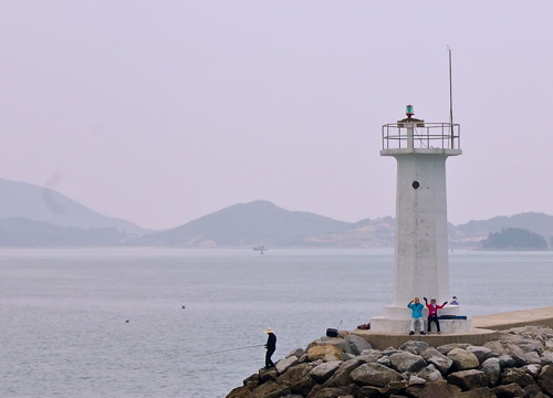
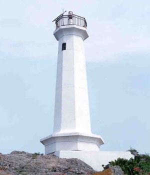
1998. Active; focal plane 11 m (36 ft); green flash every 5 s. 8 m (26 ft) octagonal white concrete tower. A photo is at right and Google has a distant satellite view. Located on the Naebal (west) breakwater of Balpo harbor. Accessible by walking the pier. Site open, tower closed. KR-2541; Admiralty M4299.75; NGA 17273.
Manyeo
2013. Active; focal plane 15 m (49 ft); nine quick white flashes every 15 s. 17 m (56 ft) round cylindrical concrete tower painted yellow with a black horizontal band. No photo available but Bing has a satellite view. Located on a reef about 1.5 km (1 mi) off the southern tip of the Goheung Peninsula. Accessible only by boat. Site open, tower closed. Admiralty M4299.73.
Jijukdo (Chijukdo, Chijuk-to, Seoraeyeo)
2002. Active; focal plane 16 m (52 ft); six quick white flashes followed by one long white flash, every 15 s. 21 m (69 ft) round tower, upper half painted yellow and lower half black. Leeho Kim has a photo, a distant view is available, and Google has a satellite view. The lighthouse marks an obstruction in a very narrow passage at the southern end of the Goheung peninsula. Located a short distance east of the bridge linking the mainland to the island of Jijukdo. Accessible only by boat. Site open, tower closed. KR-2548.2; Admiralty M4299.72; NGA 17227.
Geomdungyeo
2006. Active; focal plane 12 m (39 ft); nine quick white flashes every 15 s. 14 m (46 ft) round concrete tower, painted yellow with one black horizontal band. No photo available but Google has a satellite view. Located on a rock off the west side of the southernmost tip of the Goheung Peninsula. Accessible only by boat. Site open, tower closed. KR-2526.8; Admiralty M4299.69; NGA 17230.6.

Naebal Hang Light, Dongil, Goheung, October 2013
ex-Panoramio Creative Commons photo by §teve

Doyang District: Sisando Lighthouses
Sisando is an irregularly-shaped island about 15 km (9 mi) south of the Goheung Peninsula. The island is part of the Doyang district, although it is isolated from the rest of that district. The island is accessible by ferry.

Sisando North
1990. Active; focal plane 52 m (171 ft); white flash every 6 s. 8 m (26 ft) round white concrete tower with gallery. No photo available but Google has a distant satellite view. Located on the northwestern tip of Sisando. Site status unknown. KR-2526; Admiralty M4297.4; NGA 17230.
Sisan Hang Detached Breakwater North End
2009. Active; focal plane 13 m (43 ft); four yellow flashes every 8 s. 10 m (33 ft) round concrete tower. Entire lighthouse is yellow. All five of the Sisan Hang breakwater lights are visible in Hyungbae Park's aerial view of the harbor; this one is farthest in the distance. Google has a satellite view. Located at the north end of the detached breakwater protecting the northern entrance to Sisan harbor. Accessible only by boat. Site open, tower closed. Admiralty M4297.1.
Sisan Hang Detached Breakwater South End
2009. Active; focal plane 13 m (43 ft); two red flashes every 6 s. 10 m (33 ft) round concrete tower. Entire lighthouse is red. Visible in Hyungbae Park's aerial view of the harbor and Google has a satellite view. Located at the south end of the detached breakwater protecting the northern entrance to Sisan harbor. Accessible only by boat. Site open, tower closed. KR-2527.6; Admiralty M4297.12.
Sisan Hang Songdo West Breakwater
1998. Active; focal plane 9 m (30 ft); three green flashes every 7 s. 8 m (26 ft) round white concrete tower with gallery. Visible in Hyungbae Park's aerial view of the harbor and Google has a satellite view. Located on the breakwater on the west side of the island of Songdo in Sisan harbor. Accessible only by boat. Site open, tower closed. KR-2527; Admiralty M4297.2; NGA 17229.2.
Sisan Hang Songdo East Breakwater
1998. Active; focal plane 9 m (30 ft); red flash every 5 s. 8 m (26 ft) octagonal concrete tower with gallery, painted red. This is the red light in Kim Jong-gyu's photo, Kwang Sik Kim has a photo and Google has a satellite view. Located on the breakwater on the east side of the island of Songdo in Sisan harbor. Accessible only by boat. Site open, tower closed. KR-2528; Admiralty M4297.25; NGA 17229.5.
* Sisan Hang South Breakwater
2001. Active; focal plane 13 m (43 ft); green flash every 4 s. 10 m (33 ft) octagonal white concrete tower with gallery. This is the white light in Kim Jong-gyu's photo, and Google has a satellite view. Located on the breakwater at the entrance to the small boat harbor on the east side of Sisando. Accessible by walking the pier. Site open, tower closed. KR-2527.5; Admiralty M4297.3; NGA 17229.4.
 
Sisando (Shisando, Sisan Do)
1983. Active; focal plane 35 m (115 ft); white flash every 12 s. 6 m (20 ft) round white concrete tower with gallery. No photo available but Google has a satellite view. Located near the southern cape of a small island off the southern tip of Sisando. Accessible only by boat. Site status unknown. KR-2525; Admiralty M4297; NGA 17228.

Geumsan Township Lighthouses
Geumsan includes the relatively large island of Geogeumdo, about 16 km (10 mi) long and up to 8 km (5 mi) wide, separated from the southwest side of the Goheung Peninsula by a channel about 3 km (2 mi) wide. Bridges connect the island to the mainland. The population is about 5200.

Bugeunyeo
Date unknown. Active; focal plane about 16 m (52 ft); quick-flashing white light. Approx. 15 m (49 ft) tower, upper half painted black and lower half yellow. No photo available but Google has an indistinct satellite view. Located on a shoal just off the north coast of Geogeumdo. Accessible only by boat. Site open, tower closed. KR-2548.7; Admiralty M4298.3.
Gyedo (Kye Som)
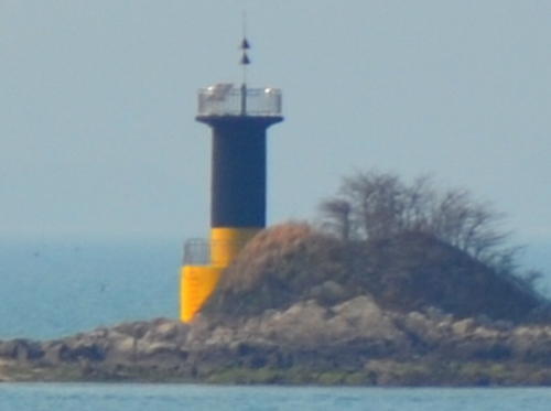
2000. Active; focal plane 12m (39 ft); six quick white flashes followed by one long white flash every 15 s. 12 m (39 ft) octagonal cylindrical concrete tower, the upper half of the tower is painted yellow and the lower half black. The Port Authority has the older photo at right showing the tower all white; the change in daymark and light characteristics was in 2020. Google has a satellite view. Located on the south point of a small island off the northeast corner of Geogeumdo. Accessible only by boat. Site open, tower closed. KR-2526.12; M4298.5; NGA 17272.5.
* Cheongseok Hang
Date unknown. Active; focal plane about 16 m (52 ft); green light, pattern unknown. Approx. 12 m (39 ft) white concrete tower. Lim Chung-shin has a 2019 photo, Soonduk Yeo has a drone view, and Google has a satellite view. Located on the breakwater of a small harbor on the east coast of Geogeumdo. Accessible by walking the pier. Site open, tower closed. KR-2548.4; Admiralty M4297.7; NGA 17225.
Monyeodo
2004. Active; focal plane 16 m (52 ft); two white flashes every 5 s. 19 m (62 ft) round concrete tower with gallery, painted black with one red horizontal band. Jeon Kyeong-ho has a 2022 photo and Google has a satellite view and a street view from shore. Located on a rock off the southeast coast of Geogeumdo. Accessible only by boat. Site open, tower closed. KR-2526.7; Admiralty M4297.5; NGA 17301.6.
Gyedo Light
Gyedo Light, Geumsan
Port of Yeosu photo
Jinmakgeum
Date unknown. Active; focal plane about 16 m (52 ft); quick-flashing white light. Approx. 15 m (49 ft) tower, upper half painted black and lower half yellow. No photo available but Google has an indistinct satellite view. Located on a shoal just off Hyeongjedo, a small island off the southwest coast of Geogeumdo. Accessible only by boat. Site open, tower closed. Admiralty M4297.58.
Odongdo (Geogeumdo Odongdo)
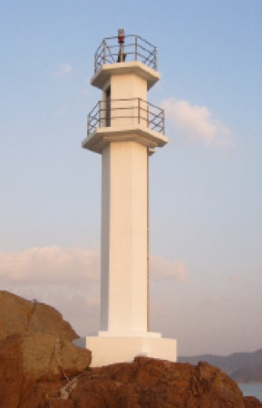
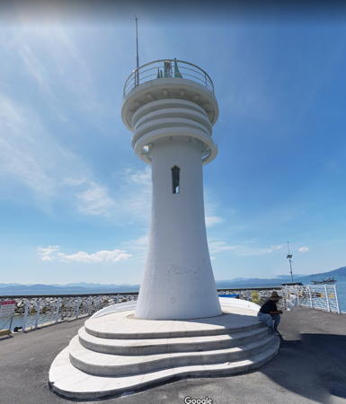
2001. Active; focal plane 39 m (128 ft); white flash every 5 s. 14 m (46 ft) octagonal concrete tower, painted white. Not to be confused with the much better known Odongdo Light at Yeosu (see the Yeosu page). A photo is at the top of this page and Google has an indistinct satellite view. This Odongdo is an island just off the western tip of Geogeumdo. The light guides vessels in the Geumdang Strait, the principal entrance to Deungnyang Bay, the bay on the west side of the Goheung peninsula. Site status unknown. KR-2553.5; Admiralty M4297.6; NGA 17301.5.
Yeonheungdo
2011. Active; focal plane 12 m (39 ft); quick-flashing white light. 11 m (36) round concrete tower, upper half painted black, lower half yellow. Suk Park has a 2019 view from the sea and Google has a satellite view. Located on a reef off the northwest tip of Geogeumdo. Accessible only by boat. Site status unknown. KR-2552.5; Admiralty M4297.65; NGA 17300.8.

Pungyang District Lighthouses
Pungyang district is on the mainland, on the southwest side of the Goheung Peninsula.

Pungnam West Breakwater (2)
2002. Active; focal plane 17 m (56 ft); green flash every 5 s. 13 m (43 ft) round cylindrical white concrete tower. Jihyun Kim has a very distant view across the harbor and Google has an indistinct satellite view. Located at the end of the main (really the south) breakwater of Pungnam, a harbor on the southwest side of the Goheung peninsula. Site status unknown. KR-2526.3; Admiralty M4298.6; NGA 17230.5.
Gamdeungseo
2005. Active; focal plane 12 m (39 ft); two white flashes every 5 s. 10 m (33 ft) round concrete tower with gallery, painted black with one red horizontal band. No photo available but Google has a satellite view. Located on a rock on the north side of the narrow channel on the north side of Geogeumdo, off Pungnam. Accessible only by boat. Site open, tower closed. KR-2526.6; Admiralty M4298.55; NGA 17230.2.

Doyang District: Nokdong and Sorokdo Lighthouses
Nokdong (formerly called Doyang) is a port at the southwestern tip of the Goheung Peninsula, sheltered by the large island of Sorokdo. The strait separating Sorokdo from Nokdong is roughly 400-500 m (1/4 mi) wide; it has been enclosed by breakwaters at both ends to create the harbor. The Sorok Bridge, completed in 2009, links Nokdong to Sorokdo.

Sorokdo (Sorok To)
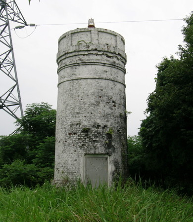
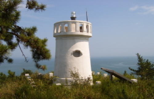
1937. Inactive since 2011. 7.5 m (25 ft) round brick tower, painted white. A photo is at right and Google has a distant satellite view. Sorokdo is an island about 3 km (1.8 mi) long located just off the port of Nokdong. The island was formerly a leper colony. During the Japanese occupation leprosy patients were forced to construct the lighthouse. Located on the southern tip of the island. Site status unknown. ex-Admiralty M4298; ex-NGA 17296.
Sorokdo West End
Date unknown. Active; focal plane 17 m (56 ft); nine quick white flashes every 15 s. 17 m (56 ft) round tower, painted yellow with one black horizontal band. No photo available but Google has a satellite view. Located just off the western tip of Sorokdo. Accessible only by boat. Site status unknown. KR-2548.1; Admiralty M4297.8; NGA 17294.
Sorokdo Light
Sorokdo Light, Nokdong
Korean Cultural Affairs Ministry photo
Sapyogido
2011. Active; focal plane 12 m (39 ft); quick-flashing white light. 11 m (36) round concrete tower, upper half painted black, lower half yellow. Kim Cheol Bong has a closeup (seen at right), a distant view is available, and Google has a satellite view. Located on a small island off the northwest coast of Sorokdo. Accessible only by boat. Site status unknown. KR-2552.4; Admiralty M4298.9; NGA 17295.
Nokdong Hang West Detached Breakwater South Head
1994. Active; focal plane 8 m (26 ft); green flash every 5 s. 8 m (26 ft) octagonal concrete tower with gallery, painted yellow. A photo of the two detached breakwater lights is available, this light is seen in the distance in Im Young Jae's photo of the Sorok Bridge (to the right of the bridge), and Google has a fuzzy satellite view. Located on the south end of a detached breakwater opposite the North Breakwater Light. Site status unknown. KR-2553; Admiralty M4299.5.
Nokdong Hang West Detached Breakwater North Head
1993. Active; focal plane 9 m (30 ft); two red flashes every 6 s. 8 m (26 ft) octagonal concrete tower with gallery, painted red. A photo of the two detached breakwater lights is available, this light is seen on the right in Im Young Jae's photo of the Sorok Bridge, a view under the bridge is available, and Google has a fuzzy satellite view. This light and the next one frame the western entrance to Nokdong harbor. Located on the north end of a detached breakwater opposite the North Breakwater Light. Site status unknown. KR-2552; Admiralty M4299.4; NGA 17299.
* Nokdong Hang North Breakwater
1999. Active; focal plane 10 m (33 ft); two green flashes every 6 s. 8 m (26 ft) octagonal white concrete tower with gallery. This light is seen under the bridge in Im Young Jae's photo of the Sorok Bridge, another photo is available, and Google has a fuzzy satellite view. Located on the breakwater in Nokdong at the northwestern entrance to the harbor. Accessible by walking the pier. Site open, tower closed. KR-2551; Admiralty M4299.2; NGA 17298.

Sapyogido Light, Sorokdo, March 2014
Google Maps photo by Kim Cheol Bong
* Nokdong Hang East Breakwater
Date unknown. Active; focal plane 9 m (30 ft); red flash every 5 s. 8 m (26 ft) concrete post rising from a round 1-story concrete equipment room. A closeup photo is available and Google has an indistinct satellite view. Located on a breakwater on the Nokdong waterfront. Site open, tower closed. KR-2553.1; Admiralty M4299.23.
Nokdong Hang South Breakwater
1993. Active; focal plane 8 m (26 ft); green flash every 5 s. 8 m (26 ft) octagonal white concrete tower with gallery. Mark Fearer's 2009 photo is at right, Park Hyeong-soon has a distant view, and Google has a satellite view. Located at the end of the breakwater extending from Sorokdo at the southwestern entrance to the harbor. Site open, tower closed. KR-2550; Admiralty M4299.6; NGA 17298.5.
Nokdong Hang Southeast Breakwater
1993. Active; focal plane 17 m (56 ft); red flash every 4 s. 12 m (39 ft) round concrete tower. Entire lighthouse is red. Jong-gyu Choi has a distant 2021 view and Google has a satellite view. Located at the south end of a detached breakwater southeast of Nokdong harbor. Accessible only by boat. Site open, tower closed. KR-2548.6; Admiralty M4299.61; NGA 17299.1.
Jangyekeunyeo
2006. Active; focal plane 9 m (30 ft); nine quick white flashes every 15 s. 16 m (52 ft) round cylindrical concrete tower with lantern, painted yellow with one black horizontal band. Google has a satellite view. Located on a shoal just off the western tip of the Goheung Peninsula. Accessible only by boat. Site open, tower closed. KR-2553.22; Admiralty M4299.65.
Hanyeo (Tungnyang Man, Sinhung)
2003. Active; focal plane 11 m (36 ft); two white flashes every 10 s. 15 m (49 ft) round cylindrical concrete tower with gallery, painted black with one red horizontal band. No photo available but Google has a satellite view. Located on a shoal off the western coast of the Goheung Peninsula. Accessible only by boat. Site open, tower closed. Admiralty M4299.68; NGA 17300.5.
Nokdong Southe Breakwater Light
Nokdong Hang South Breakwater Light, Nokdong, May 2009
ex-Panoramio photo copyright Mark Fearer; used by permission

Duwon District Lighthouses
Deungnyangman (Deungnyang Bay)
2008. Active; focal plane 9 m (30 ft); nine quick white flashes every 15 s. 14 m (46 ft) round cylindrical concrete tower with double gallery, painted black with one yellow horizontal band. Google has an indistinct satellite view. Located on a shoal off the northwestern coast of the Goheung Peninsula. Accessible only by boat. Site open, tower closed. KR-2553.23; Admiralty M4299.67.

Daeseo District Lighthouse
Daeseo is on the mainland just west of the base of the Goheung Peninsula, at the head of Deungnyang Bay.

Hayeo
2012. Active; focal plane 8 m (26 ft); two white flashes every 5 s. 12 m (39 ft) round cylindrical concrete tower painted black with one red horizontal band. No photo available but Google has an indistinct satellite view. This light guides vessels into a large sheltered bay on the northwest corner of the peninsula. Located on a shoal off the coast of the Daeseo District. Accessible only by boat. Site open, tower closed. KR-2553.25; Admiralty M4299.66.

Western Boseong County Lighthouse

Primarily an inland county, Boseong also has a coast on Deungnyang Bay opposite the northwest coast of the Goheung Peninsula.

Hoecheon Township Lighthouse
* Dorgyul Hang
Date unknown (2017?). Active; focal plane about 14 m (46 ft); green light, pattern unknown. Approx. 11 m (36 ft) round tapered white concrete tower. Part of a Google street view is at right and Google has a satellite view. Located on the west breakwater of Dorgyul harbor in Hoecheon Township. Accessible by walking the pier. Site open, tower closed. Admiralty M4299.655.

Information available on lost lighthouses:


Dorgyul Hang Light, Hoecheon, August 2017
Google Maps street view by CSL

Notable faux lighthouses:

Adjoining pages: East: Yeosu | South: Samsan Islands | West: Northern Wando Islands

Return to the Lighthouse Directory index | Ratings key

Posted January 9, 2008. Checked and revised March 5, 2024. Lighthouses: 46. Site copyright 2024 Russ Rowlett and the University of North Carolina at Chapel Hill.