Lighthouses of South Korea: Samsan Islands

For most of its history Korea was an independent kingdom, or at least an autonomous kingdom under Chinese influence. This came to an end in 1910 when Japan annexed all of Korea. At the end of World War II in 1945 the 38° parallel was established as the dividing line between U.S. and Soviet zones of occupation, and in 1948 separate civil administrations were established in the two halves of the country. The Korean War (1950-53) ended in a draw with the armistice line falling close to the prewar 38° line. The Republic of Korea (ROK; 대한민국, Daehan Minguk in Korean), commonly called South Korea, occupies the Korean peninsula south of the armistice line.

The name Korea, used internationally, is a Western version of Goryeo or Koryŏ (고려), the name of a kingdom that unified the country in the tenth century. From 1392 to 1897 the kingdom was known instead as Joseon or Chosŏn (조선). Today South Koreans usually call their country Hanguk (한국, literally "one country") and the official name of the Republic of Korea is Daehan Minguk (대한민국).

South Korea is divided into eight provinces and nine province-level cities. This page is one of three pages covering lighthouses of the municipal city of Yeosu, a major port in southeastern Jeollanam (South Jeolla) province. Yeosu is located in the central part of Korea's south coast. The city occupies the Yeosu peninsula and includes several hundred islands of all sizes, 49 of them inhabited.This page covers lighthouses of the Geomundo archipelago and other islands lying south of Goheung County and southwest of the Yeosu Peninsula in the Korea Strait. These islands are governed as the Samsan Township (Samsan-myeon) of Yeosu City.

In 2000 South Korea adopted a Revised Romanization System to replace systems formerly used in the West. In the Revised System, the word for a lighthouse is deungdae (등대); dan (formerly tan) is a cape, seom (som) or do (to) is an island, am or amseog is a rock, man is a bay, and hang is a harbor. Some place names may be more familiar to Westerners in the spellings of older systems.

Navigational aids in the ROK are regulated by the Ministry of Oceans and Fisheries (MOF). Most of the lights on this page are maintained by the Yeosu Regional Oceans and Fisheries Administration.

ARLHS numbers are from the ARLHS World List of Lights. Admiralty numbers are from volume M of the Admiralty List of Lights & Fog Signals. U.S. NGA

General Sources
World of Lighthouses - South Korea
Photos by various photographers available from Lightphotos.net.
Online List of Lights - Korea
Photos by various photographers posted by Alexander Trabas.
Navionics Charts
Navigation chart for the islands.


2006 Geomundo Light, Geoomundo, June 2021
Google Maps photo by Shin Hong-sik

Sonjukdo Area Lighthouses
Sonjukdo is an arrowhead-shaped island about 20 km (13 mi) south of the Goheung peninsula.
Daeduyeog (Taeduyok) Seo
Date unknown. Active; focal plane 34 m (112 ft); white flash every 5 s. 6 m (20 ft) round white concrete tower. The MOF photo is at right and Bing has an indistinct satellite view. Located on a skerry about 18 km (11 mi) east southeast of Sonjukdo. Accessible only by boat. Site status unknown. KR-2497; Admiralty M4300.6; NGA 17264.
Sonjukdo (Sonjuk Do)
1981. Active; focal plane 15 m (49 ft); white flash every 15 s. 10 m (33 ft) round cylindrical white concrete tower. No photo available but Google has a satellite view. Located on a skerry just off the northwestern tip of Sonjukdo. Accessible only by boat. Site status unknown. KR-2510; Admiralty M4300.4; NGA 17232.
Jimado (Chimado)
1998. Active; focal plane 24 m (79 ft); two white flashes every 6 s. 17 m (56 ft) round concrete tower, painted white. No photo available but Google has a satellite view. Located on an islet about 15 km (9 mi) southwest of Sayang and 5 km (3 mi) north of Sonjukdo. Accessible only by boat. Site status unknown. KR-2511; Admiralty M4300.5; NGA 17262.
Muhokdo
Date unknown. Active; focal plane 11 m (36 ft); white flash every 6 s. 10 m (33 ft) round white concrete tower. No photo available but Google has a satellite view. Located at the northern tip of an island about 4 km (2.5 mi) northwest of Sonjukdo. Accessible only by boat. Site status unknown. KR-2512; Admiralty M4300.55; NGA 17261.
 

Daeduyeog Seo Light, Sonjukdo, Yeosu
Yeosu Port Office photo

Chodo Area Lighthouses
Chodo is a substantial island about 6 km (3.5 mi) long and about 25 km (15 mi) south of the Goheung Peninsula and 15 km (9 mi) north of Geomundo.
Junggyeoldo (Chunggyolto, Podunaji)
2000. Active; focal plane 78 m (256 ft); two white flashes every 6 s. 10 m (33 ft) round cylindrical white concrete tower. No photo available but Google has a fuzzy satellite view. Located on a steep-sided island about 6 km (3.5 mi) north of the northern tip of Chodo. Accessible only by boat. Site status unknown. KR-2512.5; Admiralty M4296.8; NGA 17233.
Chodo East (Kkamagyeo)
2011. Active; focal plane 13 m (43 ft); three quick white flashes every 10 s. 11 m (36 ft) post mounted on a concrete pier. Lighthouse painted black with one yellow horizontal band. No photo available but Google has a satellite view. Located on a reef off the east side of Chodo. Accessible only by boat. Site status unknown. KR-2508.7; Admiralty M4295.2; NGA 17236.1.
* Uiseong Hang
Date unknown. Active; focal plane 12 m (39 ft); red flash every 5 s. 8 m (26 ft) round red concrete tower. No photo available but Google has a satellite view. Located on the breakwater of a small harbor on the southeast coast of Chodo. Accessible by walking the pier. Site open, tower closed. KR-2508.4; Admiralty M4295.1.
Chodo
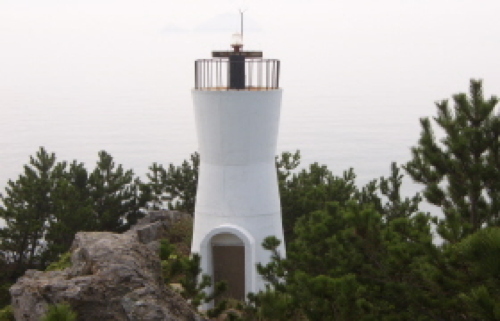
1982. Active; focal plane 55 m (180 ft); white flash every 6 s. 7 m (23 ft) round hourglass-shaped white concrete tower. The MOF photo is at right and Google has a satellite view. Located on a small island off the southeastern tip of Chodo. Accessible by walking the pier. Site open, tower closed. KR-2508; Admiralty M4295; NGA 17236.
* Chodo (Cho Do) North Breakwater
2002. Active; focal plane 18 m (59 ft); green flash every 5 s. 13 m (43 ft) octagonal concrete tower, painted white. Youngha Jae has a 2019 photo and Google has a satellite view. Located at the end of the north breakwater of Chodo harbor. Site status unknown. Admiralty M4295.3; NGA 17234.

Chodo Light, Chodo, Yeosu
Yeosu Port Office photo
Chodo West Breakwater
Date unknown. Active; focal plane about 13 m (43 ft); red light, pattern. Approx. 10 m (33 ft) round cylindrical metal tower. Entire lighthouse is red. Hee Yong Park has a very distant view and Google has a distant satellite view. Located on the detached west breakwater of Chodo harbor. Accessible only by boat but easily seen from shore. Site status unknown. KR-2508.8; Admiralty M4295.47.
[Chodo (Cho Do) South Breakwater (Inner Breakwater North End)]
2006. Active; focal plane 11 m (36 ft); red flash every 5 s. Approx. 10 m (30 ft) post attached to a small equipment cabinet. Lighthouse painted red. Jeongju Lee has a photo, the light is on the right in Youngha Jae's photo, and Google has an indistinct satellite view. Located at the north end of the inner breakwater of Chodo harbor. Accessible only by boat but easily seen from shore. KR-2508.2; Admiralty M4295.4; NGA 17234.1.
Chodo (Cho Do) Inner Breakwater South End
2006. Active; focal plane about 13 m (43 ft); green flash every 5 s. Approx. 10 m (30 ft) post rising from a round 1-story base, painted yellow. A distant photo is available and Google has an indistinct satellite view. Located at the south end of the inner breakwater of Chodo harbor. Accessible only by boat but easily seen from shore. Admiralty M4295.45.

Yeokmando Lighthouses
Yeokmando
Date unknown. Active; focal plane 21 m (69 ft); white flash every 9 s. 6 m (20 ft) round white concrete tower. No photo available but Google has a satellite view. Yeokmando is a small island about 10 km (6 mi) southeast of Chodo. Located at the northwestern tip of the island. Accessible only by boat. Site status unknown. KR-2507; Admiralty M4294.5; NGA 17240.
Yeokmando North
Date unknown. Active; focal plane 16 m (52 ft); four yellow flashes every 8 s. 13 m (43 ft) triangular metal tower. No photo available but Google has a fuzzy satellite view. Located on a reef off the northern tip of Yeokmando. Accessible only by boat. Site status unknown. KR-2507.1; Admiralty M4294.8.

Sangbaekdo Lighthouses
These lights are on a north-south chain of rocky islets and pinnacles about 25 km (15 mi) due east of Geomundo.

Munseo
2006. Active; focal plane 32 m (105 ft); white flash every 4 s. 18 m (59 ft) octagonal cylindrical white concrete tower with double gallery, mounted on an octagonal concrete base. No photo available but Google has a satellite view. Located on a rocky reef about 8 km (5 mi) north of Sangbaekdo. Accessible only by boat. Site status unknown. KR-2496.5; Admiralty M4294.3; NGA 17260.5.
Sangbaekdo (Habaegdo, Habaekdo, Habaeg Do) (2)
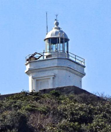
Date unknown (station established 1968). Active; focal plane 160 m (525 ft); white flash every 6 s. 7.5 m (25 ft) square cylindrical white concrete tower with lantern and gallery. Wikimapia has the photo seen at right, another photo (1/3 the way down the page) shows the top of the tower, and Google has a fuzzy satellite view. Located on a pinnacle about 25 km (15 mi) east of Geomundo. Accessible only by boat. Site status unknown. KR-2496; Admiralty M4294; NGA 17260.

Sanbaekdo Light, Geomundo Township, 2019
Wikimapia photo by steve46814

Geomundo Lighthouses
Geomundo (formerly called Komundo by Westerners) is a small group of islands in the Korea Strait about 40 km (25 mi) southeast of Wando and 60 km (37.5 mi) northeast of Jeju (Cheju). The two principal islands, Seodo on the west and Dongdo on the east, shelter a magnificent harbor between them. As a result the islands have strategic importance, and the British established a naval station called Port Hamilton on them in the 1880s. Today the islands are a popular tourist destination with the historic light station as a major attraction. The two islands are linked by a cable-stayed bridge completed in 2016. The islands are attached administratively to Yeosu City.

Sosambudo
2003. Active; focal plane 40 m (131 ft); white flash every 6 s. 13 m (43 ft) octagonal cylindrical white concrete tower with gallery. Two closeup photos are available and Google has a satellite view. Located at the eastern tip of a small island about 5 km (3 mi) northeast of the Geomundo lighthouses. Accessible only by boat. Site status unknown. KR-2497.5; Admiralty M4293.5; NGA 17243.
Ojiyeo
Date unknown. Active; focal plane about 15 m (49 ft); red light, pattern unknown. Approx. 12 m (39 ft) hexagonal red concrete tower. No photo available but Google has a satellite view. Located on a rock just off the southeastern tip of Dongdo. Accessible only by boat. Site open, tower closed. Admiralty M4293.3.
Banyeo (Pan Yeo)
1987. Active; focal plane 14 m (46 ft); two white flashes every 5 s. 15 m (49 ft) round cylindrical concrete tower with double gallery. Lighthouse painted black with one red horizontal band. No photo available but Google has an indistinct satellite view. Located on a shoal about 1.5 km (1 mi) north of Geomundo. Accessible only by boat. Site status unknown. KR-2509; Admiralty M4293; NGA 17246.
Ganyeo
Date unknown. Active; focal plane 17 m (56 ft); quick-flashing white light. 13 m (43 ft) round cylindrical concrete tower, upper half painted black and lower half yellow. Google has a satellite view and a distant street view. Located on a rock off the northern tip of Dongdo. Accessible only by boat. Site status unknown. KR-2506.1; Admiralty M4293.1.
* Noksangot (Nogsan Got) (2)
2005 (station established 1958). Active; focal plane 95 m (312 ft); white flash every 6 s. 9 m (30 ft) octagonal white concrete tower with gallery. Kim Otto's 2019 photo is at right, Jiyoen Hong has a 2021 photo, Kim Jong Hyen has a closeup photo, Minkyoung Kim has a panoramic view, and Google has a satellite view. Located on the northern point of Seodo. Site open, tower closed. KR-2506; Admiralty M4292; NGA 17248.
Dongdo North Breakwater
2000. Active; focal plane 15 m (49 ft); green flash every 5 s. 12 m (39 ft) octagonal cylindrical concrete tower with double gallery, painted white. This light and the next frame the north entrance to the protected harbor of Geomundo. Jo Joon-young has a view of both breakwater lighthouses and the bridge joining the islands, and Google has a drone view and a satellite view. Located at the end of a short breakwater at the northwestern point of Dongdo. Site status unknown. Admiralty M4292.5; NGA 17245.5.
Seodo North Breakwater
2000. Active; focal plane 15 m (49 ft); red flash every 5 s. 12 m (39 ft) octagonal cylindrical concrete tower with double gallery, painted red. A photo looking west has the Noksangot lighthouse in the background, Jo Joon-young has a view of both breakwater lighthouses and the bridge joining the islands, and Google has a drone view and a satellite view. Located at the end of a short breakwater at the northeastern point of Seodo. Site status unknown. KR-2499.6; Admiralty M4292.51; NGA 17245.
#Seodo Hang
1985. Removed around 2018. This was a 9 m (30 ft) octagonal white concrete tower with gallery. The 1-story building next to the lighthouse is probably a harbor master's office. A closeup photo is available but a 2019 drone view confirms the removal. Google has a satellite view of the location. Located on a pier in northern Seodo, a short distance inside the harbor entrance. Site open, tower closed. ex-KR-2500; ex-Admiralty M4291.

Noksangot Light, Geomundo, September 2018
Google Maps photo by Kim Otto
Geomundo Hang North Breakwater (Dongdo South Breakwater)
1989. Active; focal plane 12 m (39 ft); red flash every 4 s. 9 m (30 ft) octagonal concrete tower with gallery, painted red. A drone view is available and Google has a satellite view. This light and the next frame the southern entrance to the protected harbor of Geomundo. Located at the end of a 1 km (0.6 mi) long breakwater extending from the southwestern point of Dongdo. Site status unknown. KR-2502; Admiralty M4287; NGA 17252.
* Geomundo Hang East Breakwater
1996. Active; focal plane 12 m (39 ft); green flash every 4 s. 9 m (30 ft) round white concrete tower with gallery. Li-su Yu has a closeup street view, a drone view is available and Google has a satellite view. Located at the end of a short breakwater opposite the Dongdo South Breakwater. Accessible by walking the pier. Site open, tower closed. Admiralty M4286.5; NGA 17251.
* Geomundo Hang West Breakwater
Date unknown (recent; station established 1974). Active; focal plane 9 m (30 ft); green flash every 5 s. 7 m (23 ft) round concrete tower with lantern and gallery, painted white. Im Seongtaek has a photo, a drone view and a distant view are available, Li-su Yu has a distant street view from the East Breakwater, and Google has a satellite view. Located at the end of a short breakwater southwest of the East Breakwater. Accessible by walking the pier. Site open, tower closed. KR-2501; Admiralty M4290.2; NGA 17250.
* Geomundo (Seodo) (1)
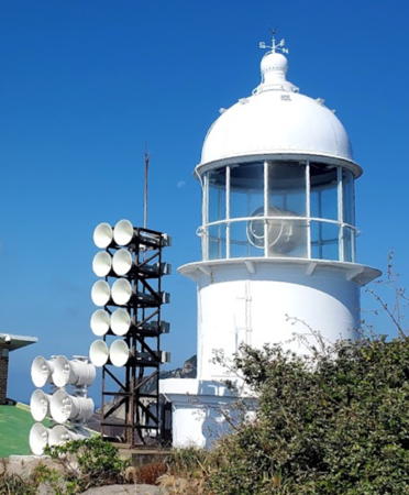
1905. Inactive since 2006. 6 m (20 ft) round concrete tower with lantern and gallery. Entire lighthouse painted white. Seonho Byeon's closeup 2022 photo is at right, the tower appears in JayHyuck Shin's photo at right, Robert Koehler's October 2007 photo shows the lens still mounted in the old tower, Baek Seung-guk has a photo of both lighthouses, and Google has a satellite view of the station. Robert Köhler also has a photo with a closeup of the fog siren, which is still active. Accommodations are available in a hostel at the station. Located at the southern tip of Seodo, the largest island of the group. Site open, tower closed. ARLHS SKR-007.
*** Geomundo (Seodo) (2)
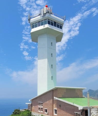
2006 (station established 1905). Active; focal plane about 95 m (312 ft); white flash every 15 s. 33 m (108 ft) hexagonal cylindrical concrete tower with lantern, gallery, and a large hexagonal observation deck. Fog siren (blast every 50 s). Entire lighthouse is white. Shin Hong-sik's 2021 photo is at the top of this page, Baek Seung-guk has a photo of both lighthouses, a 2006 photo also showing both lighthouses is available and there is a closeup of the new tower. This new lighthouse was completed in August 2006. It is clearly designed for public access, but we have no information on the schedule. Located adjacent to the historic lighthouse. Site open, tower open to the observation deck. . KR-2498; Admiralty M4286; NGA 17244.

1905 Geomundo Light, Geomundo, Yeosu, October 2022
Google Maps photo by Seonho Byeon

Information available on lost lighthouses:

Notable faux lighthouses:

Adjoining pages: North: Goheung County | Northeast: Yeosu | Southwest: Jeju | West: Chuja Islands

Return to the Lighthouse Directory index | Ratings key

Posted January 9, 2008. Checked and revised February 28, 2024. Lighthouses: 30. Site copyright 2024 Russ Rowlett and the University of North Carolina at Chapel Hill.