Lighthouses of South Korea: Southern Wando Islands

For most of its history Korea was an independent kingdom, or at least an autonomous kingdom under Chinese influence. This came to an end in 1910 when Japan annexed all of Korea. At the end of World War II in 1945 the 38° parallel was established as the dividing line between U.S. and Soviet zones of occupation, and in 1948 separate civil administrations were established in the two halves of the country. The Korean War (1950-53) ended in a draw with the armistice line falling close to the prewar 38° line. The Republic of Korea (ROK; 대한민국, Daehan Minguk in Korean), commonly called South Korea, occupies the Korean peninsula south of the armistice line.

South Korea is divided into nine provinces and eight province-level cities; the provinces are subdivided into counties and cities. This page covers lighthouses of the southern half of the island county of Wando located off South Korea's southwest coast. Wando is a county of Jeollanam Province in the region of southwestern Korea formerly known as Jeolla or Cholla. There is another page for the northern islands of the county.

In 2000 South Korea adopted a Revised Romanization System to replace systems formerly used in the West. In the Revised System, the word for a lighthouse is deungdae (등대); dan (formerly tan) is a cape, seom (som) or do (to) is an island, am or amseog is a rock, man is a bay, and hang is a harbor. Some place names may be more familiar to Westerners in the spellings of older systems.

Navigational aids in the ROK are regulated by the Ministry of Oceans and Fisheries (MOF). The lights on this page are maintained by the Mokpo Regional Oceans and Fisheries Administration.

ARLHS numbers are from the ARLHS World List of Lights. KR numbers, where available, are from the Korean light list. Admiralty numbers are from volume M of the Admiralty List of Lights & Fog Signals. U.S. NGA List numbers are from Publication 112.

General Sources
Port of Mokpo - Lighthouses
Photos and information in English for the major lighthouses of the area.
World of Lighthouses - South Korea
Photos by various photographers available from Lightphotos.net.
Online List of Lights - Korea
Photos by various photographers posted by Alexander Trabas.
Navionics Charts
Navigation chart for Wando.


Dangsado Light, Soan District, July 2021
Google Maps photo by J.G. Jeon
Cheongsan Township Lighthouses
Cheongsando is a round island, about 7 km (4.5 mi) in diameter, located in the Korea Strait about 18 km (11 mi) southeast of Wando Island. The island has a population of about 2600 and is a popular resort.
* Cheongsando (Chunsando, Chunsan To) South Breakwater (2)
2020. Active; focal plane 15 m (49 ft); red flash every 6 s. 8 m (26 ft) red post. Google has a 2021 street view from the north breakwater. The original light was a round concrete tower with gallery, painted red. Jongho Lim has a 2014 view of that light from the harbor and Google has a sea view and a satellite view. Located on the south breakwater of Cheongsando harbor, on the west side of the island. Accessible by walking the pier. Site open, tower closed. KR-2562; Admiralty M4283.4; NGA 17336.
* Cheongsando (Chunsando, Chunsan To) North Breakwater
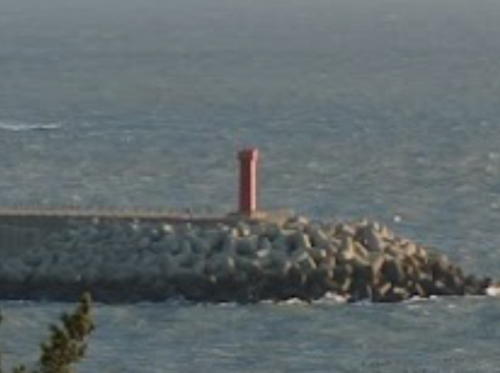
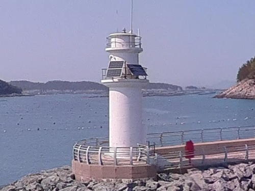
Date unknown. Active; focal plane 15 m (49 ft); green flash every 6 s. 13 m (43 ft) round concrete tower with gallery, painted white. Google has the sea view seen at right, Lee Jeong-mook has another photo, and Google has a street view and a satellite view. Accessible by walking the pier. Located on the north breakwater of Cheongsando harbor. Site open, tower closed. KR-2563; Admiralty M4283.6; NGA 17338.
Somodo (Stanley Island)
Date unknown. Active; focal plane 64 m (210 ft); white flash every 4 s. 8 m (26 ft) round white concrete tower. No photo available but Google has a distant satellite view.This light guides ships in the channel between and northern and southern Wando islands. Located at the highest point of Somodo, an island about 10 km (6 mi) west northwest of Cheongsando. Site status unknown. Admiralty M4280; NGA 17332.
* Yeoseodo West Breakwater
Date unknown. Active; focal plane 13 m (43 ft); red flash every 5 s. 8 m (26 ft) octagonal concrete tower with gallery, painted red. Núria Asghar Rafiq has a closeup photo, Dong-Hyun Han has a sunrise photo, a 2022 view showing both breakwater lighthouses is available, and Google has a satellite view. Located on the west breakwater of Yeoseodo harbor, on the north side of the island. Site open, tower closed. KR-2542.6; Admiralty M4285.1; NGA 17316.5.

Cheongsando North Breakwater Light, Cheongsan, May 2023
Google Maps photo copyright Kim Bong-sun; used by permission
* Yeoseodo East Breakwater
Date unknown. Active; focal plane 13 m (43 ft (?)); green flash every 5 s (?). 8 m (26 ft) round concrete tower with gallery, painted white. A 2022 view showing both breakwater lighthouses is available and Google has a satellite view. Located on the east breakwater of Yeoseodo harbor, on the north side of the island. Site open, tower closed. KR-2542.5; Admiralty M4285.
Yeoseodo (Yoso Do)
Date unknown. Active; focal plane 89 m (292 ft); white flash every 10 s. 8 m (26 ft) round concrete tower with gallery, painted white. A 2022 photo is at right, a closeup photo (3/4 the way down the page) is available and Google has a distant satellite view. Yeoseodo is an isolated island in the Korea Strait about 25 km (15 mi) south of Cheongsando. Located on heights above the west side of the harbor, on the north coast of the island. Site status unknown. KR-2542; Admiralty M4284; NGA 17316.

Soan Township Lighthouses
The remaining lighthouses of Wando County are in a group of closely-spaced islands lying about 20 km (13 mi) southwest of Wando itself. Soando is the easternmost of these islands.

Hoenggando
Date unknown. Active; focal plane 37 m (121 ft); white flash every 4 s. 5 m (16 ft) round white concrete tower. No photo available but Google has a satellite view. Hoenggando is a smaller island off the north coast of the larger island of Nohwado; despite its proximity to Nohwa it is governed as part of Soan Township. Located on a promontory at the northern tip of Hoenggando. Accessible only by boat. Site open, tower closed. KR-2582; Admiralty M4279.4; NGA 17320.

Yeoseodo Light, Cheongsan, October 2022
Google Maps photo by baeksun
Hoenggando East
Date unknown. Active; focal plane 21 m (69 ft); white flash every 5 s. 15 m (49 ft) white tower. No photo available but Google has a satellite view. Located on the eastern tip of Hoenggando, a smaller island off the north coast of Nohwado. Accessible only by boat. Site open, tower closed. KR-2582.1; Admiralty M4279.45.
Gaksiyeo (Gagsiseo, Kaksi So)
Date unknown. Active; focal plane 9 m (30 ft); two white flashes every 5 s. 8 m (26 ft) round concrete tower, painted black with one red horizontal band. No photo available but Google has a distant satellite view. Located on a reef about 1.6 km (1 mi) north of Soando. Accessible only by boat. Site open, tower closed. KR-2580; Admiralty M4279.5; NGA 17324.
 
Daeseo
Date unknown. Active; focal plane 12 m (39 ft); red flash every 5 s. 11 m (36 ft) round concrete tower, painted red. Li-su Yu has a very distant street view and Google has a satellite view. Located on a reef just off the northwestern tip of Soando. Accessible only by boat. Site open, tower closed. KR-2581.5; Admiralty M4279.6; NGA 17325.
Tanyeo
Date unknown. Active; focal plane 14 m (46 ft); two red flashes every 6 s. 20 m (66 ft) round cylindrical concrete tower with double gallery. Entire lighthouse is red. Hay Retona has a 2023 view, Jeongim Lee has a distant view, and Google has a satellite view. Located just off the southwestern coast of Soando. Accessible only by boat. Site open, tower closed. KR-2597; Admiralty M4279.88; NGA 17327.4.
Soan Hang West Breakwater
Date unknown. Active; focal plane 14 m (46 ft); red flash every 5 s. 8.5 m (28 ft) octagonal concrete tower, painted red. A closeup street view is available, Fatkur Rozi has a photo showing both breakwater lighthouses, and Google has a satellite view. Located on the west breakwater of Soan harbor. Accessible by walking the pier. Site open, tower closed. KR-2598; Admiralty M4279.8; NGA 17327.
Soan Hang North Breakwater
Date unknown. Active; focal plane 13 m (43 ft); green flash every 5 s. 8.5 m (28 ft) octagonal concrete tower, painted green. A closeup street view is available, Fatkur Rozi has a photo showing both breakwater lighthouses, and Google has a satellite view. Located on the north breakwater of Soan harbor. Accessible by walking the pier. Site open, tower closed. KR-2599; Admiralty M4279.85; NGA 17327.1.
*** Dangsado (Jagaedo, Chagaedo, Dongsado) (1)
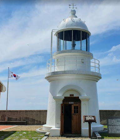
1909. Inactive since 2008. 8 m (26 ft) round concrete tower with lantern and gallery. Lighthouse painted white. J.G. Jeon's photo is at right, a 2022 photo is available, and Google has a satellite view of the station. 1-story coast guard station buildings. In 2008 plans were announced to restore the lighthouse and open the light station to visitors on the occasion of its 100th anniversary in 2009. One of the station buildings was renovated as a museum. Jagaedo (Dongsado) is a small island southwest of Soando and about 30 km (19 mi) southwest of Wando. There is ferry service from Wando to Bogildo, and transportation to Jagaedo is also available. Located on the southeastern point of the island. Site open, tower closed.
*** Dangsado (Jagaedo, Chagaedo, Dongsado) (2)
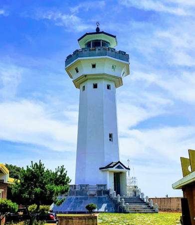
2008 (station esatblished 1909). Active; focal plane 109 m (358 ft); white flash every 20 s. 21 m (69 ft) octagonal concrete tower with lantern and gallery. Rotating aerobeacon. Lighthouse painted white; lantern roof is red. Fog siren (8 s blast every 48 s on request). J.G. Jeon's photo is at the top of this page, Jaeyean Whang has a 2022 photo, and Google has a satellite view of the station. Located on the southeastern point of the island. Site open; the tower is evidently open but we have no details. . Admiralty M4282; NGA 17340.

Old Dangsado Light, Soan District, July 2021
Google Maps photo by J.G. Jeon

Nohwa Town Lighthouses
Nohwado is an island about 5 km (3 mi) in diameter located northwest of Soando and north of Bogildo. The Nohwa District also includes a scattering of small islands to the northwest.

Seokdo (Sokto)
Date unknown. Active; focal plane 10 m (33 ft); three quick white flashes every 10 s. 11 m (36 ft) tower painted black with one yellow horizontal band. No photo available but Google has a satellite view. Located on a shoal about halfway between northern Soando and southern Nohwado. Accessible only by boat. Site open, tower closed. KR-2585; Admiralty M4279.7; NGA 17326.
Cheongri (Jungri, Chungri)
Date unknown. Active; focal plane 8 m (26 ft); green light, pattern unknown. 11 m (36 ft) round concrete tower, painted green. No photo available but Google has an indistinct satellite view. Located on the southernmost point of Nohwado. Site status unknown. KR-2600; Admiralty M4279.73.
Seoneobdo (Seoneopdo)
Date unknown. Active; focal plane 51 m (167 ft); white flash every 4 s. 11 m (36 ft) round white concrete tower. No photo available but Google has a satellite view. Located at the southwest end of Seoneobdo, an island about 5 km (3 mi) northwest of Bogildo. Site status unknown. Admiralty M4278.15; NGA 17531.
Jugguldo (Jukguldo, Chukkul Do) (2)
2019 (station established 1987). Active; focal plane 51 m (167 ft); white flash every 6 s. 12 m (39 ft) round white concrete tower with lantern and gallery. No photo available but Google has a satellite view. Located on a small island about 7 km (4 mi) northwest of Seoneobdo. Accessible only by boat. Site status unknown. KR-2604; Admiralty M4278.2; NGA 17530.
Milmaedo
Date unknown. Active; focal plane 54 m (177 ft); white flash every 4 s. 11 m (36 ft) round white concrete tower. No photo available but Google has a satellite view. Located on a small island, about 7 km (4 mi) northwest of Juggul. Accessible only by boat. Site status unknown. KR-2605; Admiralty M4278.3; NGA 17529.
Eoryongdo (Oryongdo)
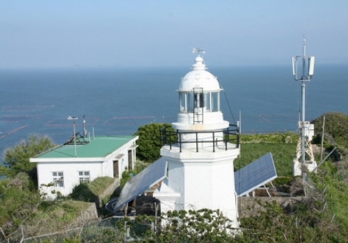
1910 (rebuilt after World War II). Active; focal plane 93 m (305 ft); white flash every 15 s. 8 m (26 ft) octagonal concrete tower with lantern and gallery. Lighthouse painted white. Fog horn (one blast every 40 s). Two 1-story concrete keeper's cottages. A photo is at right, a page for the lighthouse has many photos, and Google has a distant satellite view of the station. The lighthouse was destroyed by U.S. air raids late in World War II but was rebuilt with U.S. assistance after the war. Oryongdo is a high island about 8 km (5 mi) south of Oran. Located on the highest point of the island, near the northeast end. Accessible only by boat. Site status unknown. Admiralty M4278; NGA 17532.
Eoryongdo Light
Eoryongdo Light, Nohwa District
Korean Tourism Organization photo

Bogil Township Lighthouses
Bogildo is an island about 6.5 km (4 mi) in diameter connected by a bridge to Nohwado.

Churuncho (Wandocho)
Date unknown. Active; focal plane 20 m (66 ft); two white flashes every 10 s. 24 m (79 ft) square cylindrical metal tower, painted black with one red horizontal band, on a square platform supported by piles. No photo available but Bing has a satellite view. Located about 5 km (3 mi) south of the southern tip of Bogildo. Accessible only by boat. Site open, tower closed. KR-2597.2; Admiralty M4283; NGA 17341.
* Boog (Book) Hang South Breakwater
2010. Active; focal plane 15 m (49 ft); red flash every 4 s. 8 m (26 ft) round metal tower painted red. Hojin Ahn's distant view is at right, very distant view is available (this light is on the right), Jaeheung Ahn has an aerial view and a view from the waterfront (this light is on the left in both cases), and Google has a satellite view. Located on the south (main) breakwater of a small harbor on the southwestern coast of Bogildo. Accessible by walking the pier. Site open, tower closed. KR-2581.1; Admiralty M4283.2.
* Boog (Book) Hang North Breakwater
2010. Active; focal plane 11 m (36 ft); green flash every 4 s. 9 m (30 ft) round white concrete tower. Park In Bae has a view across the harbor, a very distant view is available (this light is on the left), Jaeheung Ahn has an aerial view and a view from the waterfront (this light is on the right in both cases), and Google has a satellite view. Located on the north breakwater of a small harbor on the southwestern coast of Bogildo. Accessible by walking the pier. Site open, tower closed. KR-2581.2; Admiralty M4283.3.
Pajanggak
2020. Active; focal plane 12 m (39 ft); nine quick white flashes every 15 s. 13 m (43 ft) round concrete tower colored yellow with one black horizontal band. No photo available but Google has a satellite view. Located just off the western tip of Bogildo. Accessible only by boat. Site open, tower closed. KR-2581.3; Admiralty M4283.31.
Cheongdongri (Jeongdongri)
Date unknown. Active; focal plane 9 m (30 ft); white flash every 6 s. 8 m (3266 ft) round concrete tower, painted white. No photo available but Google has a satellite view. Located on the northernmost point of Bogildo, marking the entrance to the strait separating Bogildo from Nohwado. Site status unknown. KR-2601; Admiralty M4279.75.

South Breakwater Light, Boog Hang, December 2015
Google Maps photo by Hojin Ahn
Yejakdo
Date unknown. Active; focal plane 10.5 m (34 ft); red flash every 5 s. 10.5 m (34 ft) round steel tower painted red. In a very distant 2024 view the light is near the left edge (use zoom) and Google has a distant satellite view. Located on a shoal in the narrow passage between the southwest coast of Bogildo and the island of Yejakdo. Accessible only by boat. Site open, tower closed. KR-2600.3; Admiralty M4283.33.

Information available on lost lighthouses:

Notable faux lighthouses:

Adjoining pages: North: Northern Wando | South: Chuja Islands

Return to the Lighthouse Directory index | Ratings key

Posted January 9, 2008. Lighthouses: 27. Checked and revised April 5, 2024. Site copyright 2024 Russ Rowlett and the University of North Carolina at Chapel Hill.