Lighthouses of Korea: Chuja Islands

For most of its history Korea was an independent kingdom, or at least an autonomous kingdom under Chinese influence. This came to an end in 1910 when Japan annexed all of Korea. At the end of World War II in 1945 the 38° parallel was established as the dividing line between U.S. and Soviet zones of occupation, and in 1948 separate civil administrations were established in the two halves of the country. The Korean War (1950-53) ended in a draw with the armistice line falling close to the prewar 38° line. The Republic of Korea, commonly called South Korea, occupies the Korean peninsula south of the armistice line.

The name Korea, used internationally, is a Western version of Goryeo or Koryŏ (고려), the name of a kingdom that unified the country in the tenth century. From 1392 to 1897 the kingdom was known instead as Joseon or Chosŏn (조선). Today South Koreans usually call their country Hanguk (한국, literally "one country") and the official name of the Republic of Korea is Daehan Minguk (대한민국).

South Korea is divided into eight provinces and nine province-level cities. Jeju (formerly spelled Cheju) is an island province located off the southwestern end of the Korean Peninsula. The island is divided administratively into two cities, Jeju on the north side and Seogwipo on the south side. Also a part of Jeju Province, Chuja is a group of islands located roughly halfway between Jeju and the mainland and roughly 40 km (25 mi) north northwest of Jeju city. The group includes two larger islands connected by a bridge, Hachujado (Lower Chuja) on the east and Sangchujado (Upper Chuja) on the west, as well as many islets nearby. The islands comprise a township (myeon) of Jeju City and are accessible by ferries from Jeju City and from Wando on the mainland.

Navigational aids in the ROK are regulated by the Ministry of Oceans and Fisheries (MOF). The lights on this page are maintained by the Jeju Oceans and Fisheries Management Division, a branch of the Busan Regional Oceans and Fisheries Administration.

In 2000 South Korea adopted a Revised Romanization System to replace systems formerly used in the West. In the Revised System, the word for a lighthouse is deungdae (등대); dan (formerly tan) is a cape, seom (som) or do (to) is an island, am or amseog is a rock, man is a bay, and hang is a harbor.

ARLHS numbers are from the ARLHS World List of Lights. Admiralty numbers are from volume M of the Admiralty List of Lights & Fog Signals. U.S. NGA List numbers are from Publication 112.

General Sources
World of Lighthouses - South Korea
Photos by various photographers available from Lightphotos.net.
Online List of Lights - Korea
Photos by various photographers posted by Alexander Trabas.
Navionics Charts
Navigational chart for the islands.


Sangchujado Light, Chuja, August 2016
Google Maps photo by Lee Hae-il
Sangchujado Lighthouses
* Chuja Hang Breakwater
Date unknown. Active; focal plane 16 m (52 ft); red flash every 4 s. 11 m (36 ft) round concrete tower. Entire lighthouse is red. A distant view and a drone view are available, there is a view (fifth photo on the page) of both Chuja Hang lighthouses, and Google has a distant satellite view. Located on the breakwater of Chuja harbor, on the north side of Sangchujado. Accessible by walking the pier. Site open, tower closed. Admiralty M4277; NGA 17352.
Chuja Hang
Date unknown. Active; focal plane 14 m (46 ft); green flash every 5 s. 12 m (39 ft) round concrete tower. Entire lighthouse is green. A drone view and a view from shore are available, there is a view (fifth photo on the page) of both Chuja Hang lighthouses, and Google has a satellite view. This is the station listed by NGA as "Chuja Kundo." Located on a rock in the entrance to Chuja harbor, on the east side of the entrance channel. Accessible only by boat. Site open, tower closed. KR-2607; Admiralty M4276; NGA 17348.
#Sangchujado (1)
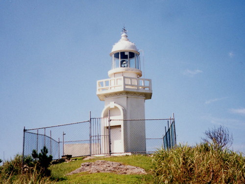
1980. Inactive since 2006 and apparently demolished in that year. 7 m (23 ft) hexagonal cylindrical concrete tower with lantern and gallery, painted white. A photo is at right.
*** Sangchujado (2)
2006. Active; focal plane 145 m (476 ft); white flash every 20 s. Fog horn (blast every 40 s). 20 m (66 ft) round cylindrical white concrete tower with lantern and gallery rising from a 2-story building. Lee Hae-il's photo is at the top of this page, W.Y. Han has a 2023 photo, Steve Oberhauser has a photo (halfway down the page), a portfolio of photos (second half of the page) is available, W.J. Cho has a closeup photo of the light tower, and Google has a satellite view of the station. The station includes a small lighthouse museum. Located on heights in the southeast of Sangchujado. Site and museum open, and visitors can enjoy the view from the roof of the building; tower closed. KR-2606; Admiralty M4277.5; NGA 17356.
Goryeoyeo
2008. Active; focal plane 13 m (43 ft); two white flashes every 10 s. 17 m (56 ft) round cylindrical concete tower, painted black with one red horizontal band. Chansu Park has a distant 2023 view and Google has a satellite view. Located on a reef about 800 m (1/2 mi) southwest of the southern entrance to the strait separating Hachujado and Sangchujado. Accessible only by boat. Site open, tower closed. Admiralty M4277.6; NGA 17357.
Chuja Kundo Light
1980 Sangchujado Light, Chuja, 2005 (later demolished)
Korean Sea Tourist Information Portal photo (no longer online)

Hachujado Lighthouses
* Yecho Hang
Date unknown. Active; focal plane 15 m (49 ft); green flash every 6 s. 12 m (39 ft) round cylindrical white concrete tower. Byung-chai Park has a 2021 photo taken across the harbor and Google has a satellite view. Located at the end of the breakwater at Yecho village, on the north coast of Hachujado. Accessible by walking the pier. Site open, tower closed. KR-2612.5; Admiralty M4275.2.
Gamagyeo (Kamegyeo)
Date unknown. Active; focal plane 15 m (49 ft); two white flashes every 5 s. 10 m (33 ft) round concrete tower painted black with one red horizontal band. Taeyeol Roh has a distant view from shore and Google has an indistinct satellite view. Located at the north point of a reef about 800 m (1/2 mi) off the north coast of Chuja. Accessible only by boat. Site open, tower closed. KR-2612; Admiralty M4275; NGA 17360.
Sinyang Breakwater (3)
2019. Active; focal plane 21 m (69 ft); red flash every 4 s. 12 m (39 ft) round red concrete tower with lantern and gallery. Myeongsan Choi has a distant 2021 street view and Google has a satellite view. This lighthouse replaced a round concrete tower. That tower was removed in connection with rebuilding and extension of the breakwater. In 2018 a temporary light on a red steel post was in service; a drone view is available. Located on the east breakwater of Sinyang, at the east end of Hachujado. Accessible by walking the pier. Site open, tower closed. Active light: KR-2616.2; Admiralty M4274.8; NGA 17366.
Sinyang South Breakwater (3)
2019. Active; focal plane 19 m (62 ft); green flash every 4 s. 12 m (39 ft) round white concrete tower with lantern and gallery. Part of Myeongsan Choi's 2021 sunrise street view is at right, Yonggil Kim also a 2022 photo, and Google has a satellite view. In 2018 a temporary light on a white steel post was in service; a drone view is available. Located on the south breakwater of Sinyang. Accessible by walking the pier. Site open, tower closed. Active light: KR-2616; Admiralty M4274.85; NGA 17366.5.

Northern Islets Lighthouses
Hoenggando (Hoenggan Do) (2)
2007 (station established in 1983). Active; focal plane 25 m (82 ft); white flash every 10 s. 10 m (33 ft) round cylindrical concrete tower mounted on a large 2-stage square concrete base. Entire lighthouse is white. No photo of the current light is available but Google has a satellite view. NGA misspells the name as Heonggando. Located on a rocky reef about 7 km (4 mi) northeast of Chuja Hang. Accessible only by boat. Site status unknown. KR-2603; Admiralty M4277.8; NGA 17344.

Sinyang South Breakwater Light, Chuja, June 2021
Google Maps street view by Myeongsan Choi
Mangdo (Mang Do)
Date unknown. Active; focal plane 75 m (246 ft); two white flashes every 9 s. 8.5 m (28 ft) round concrete tower. Entire lighthouse is white. Kim Myung-Kwan has a 2021 distant view from the sea and Google has a distant satellite view. Located on an islet at the northeastern corner of the Chuja group, about 10 km (6 mi) northeast of Sangchujado. Accessible only by boat. Site status unknown. KR-2609; Admiralty M4277.9; NGA 17364.

Eastern Islets Lighthouses
Sasudo (Changsudo)
Date unknown. Active; focal plane 84 m (276 ft); white flash every 6 s. 11 m (36 ft) octagonal concrete tower, painted white. No photo available but Google has a distant satellite view. Sasudo (Changsudo) is an isolated islet about 30 km (19 mi) due east of Chuja-do. Accessible only by boat. Site status unknown. KR-2543; Admiralty M4283.8; NGA 17398.
Bangseo (Bang Seo)
Date unknown. Active; focal plane 25 m (82 ft); white flash every 6 s. 11 m (36 ft) round cylindrical concrete tower. Entire lighthouse is white. No photo available but Google has a distant satellite view. Located on a small island about 10 km (6 mi) southeast of Chuja. Accessible only by boat. Site status unknown. KR-2613; Admiralty M4274.7; NGA 17368.

Southern Islets Lighthouses
Jungnoe
2013. Active; focal plane 25 m (82 ft); two white flashes every 5 s. 39 m (128 ft) (?) round tower, painted black with a red horizontal band. No photo available and the tower is not seen in Bing's satellite view of the location. Located on a reef about 15 km (9 mi) south of Sangchujado. Accessible only by boat. Site open, tower closed. KR-2613.1; Admiralty M4274.67.
Hwado (Hwa Do)
Date unknown. Active; focal plane 92 m (302 ft); white flash every 5 s. 7 m (23 ft) square white concrete tower. No photo available but Google has an indistinct satellite view. Located atop a huge monolith about halfway between Chuja and Jeju. Accessible only by boat. Site status unknown. KR-2614; Admiralty M4274.65; NGA 17372.

Information available on lost lighthouses:

Notable faux lighthouses:

Adjoining page: North: Jindo | Northeast: Southern Wando Islands | South: Jeju City

Return to the Lighthouse Directory index | Ratings key

Posted December 10, 2007. Checked and revised March 13, 2024. Lighthouses: 15. Site copyright 2024 Russ Rowlett and the University of North Carolina at Chapel Hill.