Lighthouses of South Korea: Central Sinan Islands

For most of its history Korea was an independent kingdom or at least an autonomous kingdom under Chinese influence. This came to an end in 1910 when Japan annexed all of Korea. At the end of World War II in 1945 the 38° parallel was established as the dividing line between U.S. and Soviet zones of occupation, and in 1948 separate civil administrations were established in the two halves of the country. The Korean War (1950-53) ended in a draw, with the armistice line falling close to the prewar 38° line. The Republic of Korea (ROK), commonly called South Korea, occupies the Korean peninsula south of the armistice line.

South Korea is divided into nine provinces and eight province-level cities; the provinces are subdivided into counties and cities. This page covers lighthouses of Sinan County, an island county of Jeollanam (South Jeolla) Province, located on South Korea's southwest coast in the region known as Jeolla or Cholla. The county comprises a large archipelago west of Mokpo. Also included in the county are the Northern Sinan Islands to the north and the Heuksan Islands to the southwest.

In 2000 South Korea adopted a Revised Romanization System to replace systems formerly used in the West. In the Revised System, the word for a lighthouse is deungdae (등대); dan (formerly tan) is a cape, seom (som) or do (to) is an island, am or amseog is a rock, man is a bay, and hang is a harbor. Some place names may be more familiar to Westerners in the spellings of older systems.

Navigational aids in the ROK are regulated by the Ministry of Oceans and Fisheries (MOF). Lighthouses in Sinan are maintained by the Mokpo Regional Maritime Affairs and Port Authority.

ARLHS numbers are from the ARLHS World List of Lights. KR numbers, where available, are from the Korean light list. Admiralty numbers are from volume M of the Admiralty List of Lights & Fog Signals. U.S. NGA List numbers are from Publication 112.

General Sources
Port of Mokpo - Lighthouses
Photos and information in English for the major lighthouses of the area.
Lighthouses in South Korea
Photos available from Wikimedia.
Online List of Lights - Korea
Photos by various photographers posted by Alexander Trabas.
Navionics Charts
Navigation chart for the islands.

Chilbaldo Light
Chilbaldo Light, Bigeum
MOF photo posted by Korean Association of Aids to Navigation
Jangsan Township (Jangsando Area) Lighthouses
Majindo
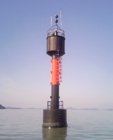
Date unknown. Active; focal plane 11 m (36 ft); two white flashes every 5 s. 17 m (56 ft) round concrete tower painted black with one red horizontal band. A photo is at right and Google has a satellite view. Located on a shoal in the passage about 2.5 km (1.5 mi) southeast of Jangsando and a similar distance off the mainland. Accessible only by boat. Site open, tower closed. Admiralty M4236.5; NGA 17595.
Gudo (Ku Do)
Date unknown. Active; focal plane 29 m (95 ft); white flash every 4 s. 7.5 m (25 ft) round white concrete tower. No photo available but Google has a satellite view. Located on an islet about 5 km (3 mi) off the north coast of Jindo, guiding vessels toward the north end of the Myeongnyang Strait. Accessible only by boat. Site status unknown. KR-3053; Admiralty M4236; NGA 17596.
Jangdo (Changdo)
Date unknown. Active; focal plane 31 m (102 ft); white flash every 6 s. 9 m (30 ft) round white concrete tower. No photo available but Google has a satellite view. Located on a small island off the eastern tip of Majindo, a small island southeast of Jangsando, marking the passage northward from Jindo toward Mokpo. Accessible only by boat. Site status unknown. KR-3063; Admiralty M4237; NGA 17612.
Jangsando
Date unknown. Active; focal plane 11 m (36 ft); red flash every 6 s. 11 m (36 ft) round concrete tower painted red. No photo available but Google has a satellite view. Located on a shoal off the western tip of Majindo. Accessible only by boat. Site open, tower closed. KR-3059.1; Admiralty M4236.8.

Sinui Township (Sinuido Area) Lighthouses
Jisiido (Chisi Do)
Date unknown. Active; focal plane 50 m (164 ft); white flash every 6 s. 10 m (33 ft) round cylindrical white concrete tower. No photo available but Google has a satellite view. Located on a small island off the southwestern tip of Sinuido, the principal island of the Sinui Township. Accessible only by boat. Site open, tower closed. Admiralty M4235; NGA 17586.
Neolbeunyeo (Pajangyeo)
Date unknown. Active; focal plane 17 m (56 ft); red flash every 6 s. 18 m (59 ft) round concrete tower centered on a large round concrete base. Entire lighthouse is red. Google has a satellite view. Located on a small island in the narrow passage between Sinuido and Hauido, near the southern end of the Sinan islands. Accessible only by boat. Site open, tower closed. KR-3052.1; Admiralty M4228.4; NGA 17586.5.
Majindo Light
Majindo Light, Jangsan
Port of Mokpo photo (no longer online)

Haui Township (Hauido Area) Lighthouses
Sindo (Shindo)
Date unknown. Active; focal plane 16 m (52 ft); white flash every 5 s. 8 m (26 ft) round white concrete tower. No photo available but Google has a satellite view. Located at the western tip of Sindo, an island off the west coast of Hauido. Accessible only by boat. Site status unknown. KR-3104; Admiralty M4228.6; NGA 17587.
Jangbyeongdo (Changbyong Do)
2010. Active; focal plane 14 m (46 ft); white flash every 6 s. 11 m (26 ft) octagonal white concrete tower. No photo available but Google has a satellite view. Located at the northern tip of an island off the north coast of Hauido. Accessible only by boat. Site status unknown. KR-3064.1; Admiralty M4231.6; NGA 17589.

Docho (Tocho) Township (Dochodo Area) Lighthouses
Bido (Pido, Ui-Gundo)
Date unknown. Active; focal plane 27 m (89 ft); two white flashes every 6 s. 9 m (30 ft) round cylindrical white concrete tower. No photo available but Google has a satellite view. Located on a small island about 13 km (8 mi) south of Dochodo. Accessible only by boat. Site status unknown. KR-3103; Admiralty M4228.5; NGA 17588.
Uido (Ueuido)
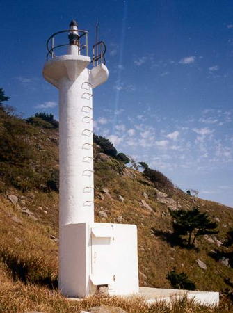
Date unknown. Active; focal plane 83 m (272 ft); white flash every 5 s. 8 m (26 ft) white concrete post attached to a small 1-story equipment shelter. A photo is at right and Google has a distant satellite view. Located at the west end of Uido, an island west of Dochodo. Site status unknown. KR-3100; Admiralty M4228.8; NGA 17646.
Uido North Breakwater
Date unknown. Active; focal plane 12 m (39 ft); two red flashes every 6 s. 8 m (26 ft) red concrete tower. A 2023 street view is available, Dong Kim has a distant aerial view, and Google has a satellite view. Located on the north breakwater of Uido harbor, at the east end of the island. Site open, tower closed. KR-3060.3; Admiralty M4228.95.
Uido South Breakwater
Date unknown. Active; focal plane 12 m (39 ft); two green flashes every 6 s. 8 m (26 ft) white concrete tower. A closeup 2023 street view is available, Dong Kim has a distant aerial view, and Google has a satellite view. Located on the south breakwater of Uido harbor, at the east end of the island. Site open, tower closed. KR-3060.2; Admiralty M4228.9.

Uido Light, Docho, October 2016
Librewiki.net Creative Commons photo
Gyeongchido (Gyongchido, Kyongchido) (2)
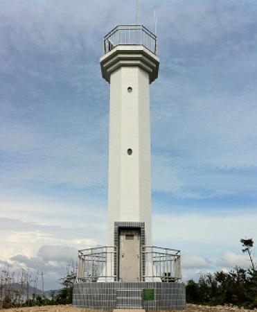
Date unknown. Active; focal plane 47 m (154 ft); white flash every 4 s. 9 m (30 ft) octagonal cylindrical white concrete tower. Google has a distant satellite view. The original light was on a round tower. Located at the east end of an island about 10 km (6 mi) northeast of Uido. Accessible only by boat. Site status unknown. Admiralty M4229; NGA 17648.
Jongdaram (Chongdar-Am)
Date unknown. Active; focal plane 8 m (26 ft); two white flashes every 10 s. 18 m (59 ft) square skeletal tower mounted on a square concrete pier. Lighthouse painted black with one red horizontal band. No photo available but Google has a satellite view. Located on a reef about 3 km (1.8 mi) east of Gyongchido. Accessible only by boat. Site open, tower closed. KR-3102.5; Admiralty M4229.1; NGA 17649.
Docho (Touch'ado)
Date unknown. Active; focal plane 14 m (46 ft); white flash every 6 s. 8.5 m (28 ft) octagonal white concrete tower. No photo available but Google has a satellite view. Located on the northern tip of Dochodo, marking the eastern entrance to the strait between Dochodo and Bigeumdo. Site status unknown. KR-3116; Admiralty M4230.8; NGA 17650.
Jeungdo (Jeung Do)
Date unknown. Active; focal plane 15 m (49 ft); white flash every 4 s. 8 m (26 ft) round white concrete tower. No photo available but Google has a distant satellite view. Located at the north point of a small island about 3 km (2 mi) east of the Docho light. Accessible only by boat. Site status unknown. KR-3115; Admiralty M4231; NGA 17656.
Mado (Malseom)
Date unknown. Active; focal plane 14 m (46 ft); white flash every 5 s. 12 m (39 ft) round white concrete tower. No photo available but Google has a satellite view. Located on a small island about 2 km (1.25 mi) off the northeast coast of Dochodo. Accessible only by boat. Site status unknown. KR-3115.1; Admiralty M4231.3; NGA 17657.1.
Migido
Date unknown. Active; focal plane 18 m (59 ft); white flash every 5 s. 15 m (49 ft) round white concrete tower. No photo available but Google has a satellite view. Located on a small island off the eastern tip of Dochodo. Accessible only by boat. Site status unknown. KR-3102.7; Admiralty M4231.5; NGA 17658.

Gyeongchido Light, Docho, October 2016
Librewiki.net Creative Commons photo

Bigeum Township (Bigeumdo Area) Lighthouses
Chilbaldo
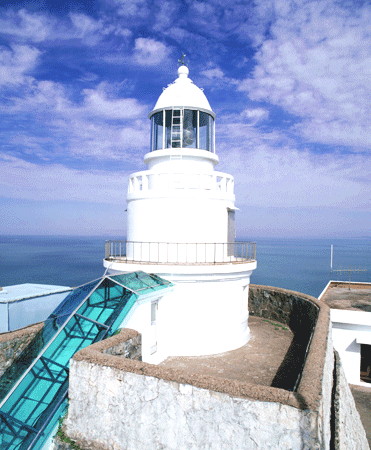
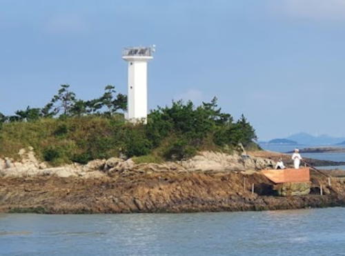
1905. Active; focal plane 105 m (345 ft); white flash every 15 s. 8.5 m (29 ft) round concrete tower with lantern and gallery. Lighthouse painted white. Several additional station buildings. A photo is at the top of this page, a distant view from the sea is available, and Google has a satellite view. Located on a small island about 50 km (30 mi) due west of Mokpo. Accessible only by boat, and the island is a restricted bird sanctuary. Site status unknown. KR-3110; Admiralty M4212; NGA 17672.
Bokdo (Bogdo, Pokto)
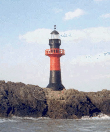
Date unknown. Active; focal plane 16 m (52 ft); two white flashes every 10 s. 11 m (36 ft) round concrete tower with lantern and gallery, painted black with one red horizontal band. A photo is at right and Bing has a satellite view. Located on a reef about 6 km (3.5 mi) southwest of Bigeumdo. Accessible only by boat. Site status unknown. KR-3105; Admiralty M4229.5; NGA 17645.
Daegokdo (Daegogdo)
Date unknown. Active; focal plane 35 m (115 ft); two white flashes every 6 s. 8 m (26 ft) round white concrete tower. No photo available but Google has a satellite view. Located on the south end of an island off the western entrance to the strait between Bigeumdo and Dochodo. Accessible only by boat. Site status unknown. Admiralty M4230; NGA 17643.
Jangguseom (Janggu Seo, Changgu-so)
Date unknown. Active; focal plane 19 m (69 ft); white flash every 5 s. 9 m (29 ft) round white concrete tower. No photo available but Google has a satellite view. Located on an islet off the west coast of Bigeumdo, about 4 km (2.5 mi) northwest of Daegogdo. Accessible only by boat. Site status unknown. KR-3105.8; Admiralty M4229.8; NGA 17644.5.
Usedo (Use Do)
Date unknown. Active; focal plane 68 m (233 ft); white flash every 4 s. 9 m (30 ft) round white concrete tower. The light can be seen in an aerial photo and Google has a satellite view. Located on the west end of an uninhabited island off the northwest corner of Bigeumdo, sheltering Wonpyong. Accessible only by boat. Site status unknown. KR-3111; Admiralty M4212.5; NGA 17668.
Usedo (Use Do) Southeast
2020. Active; focal plane 13 m (43 ft); nine quick white flashes followed by one long white flash every 15 s. 10 m (33 ft) round concrete tower, upper half painted yellow and lower half black. No photo available but Google has a satellite view. Located on a shoal off the southeastern point of Usedo. Accessible only by boat. Site open, tower closed. KR-3111.1; Admiralty M4212.55; NGA 17668.1.
* Wonpyeong (Wonpyong) Hang West Breakwater
Date unknown. Active; focal plane 14 m (46 ft); two red flashes every 6 s. 9 m (30 ft) round concrete tower. Entire lighthouse is red. A closeup photo is available, Dong Kim has a distant aerial view, and Google has a satellite view. Located on the west breakwater of Wonpyong harbor, on the north coast of Bigeumdo. Probably accessible by walking the pier. Site open, tower closed. KR-3114; Admiralty M4212.7; NGA 17669.
Wonpyeong (Wonpyong) Hang East Breakwater (2)
Date unknown. Active; focal plane 11 m (36 ft); two green flashes every 6 s. 9 m (30 ft) round concrete tower. Entire lighthouse is white. A closeup photo is available, Dong Kim has a distant aerial view, and Google has a satellite view. NGA lists a light on a mast. Located at the west end of a detached breakwater of Wonpyong harbor. Site open, tower closed. KR-3113; Admiralty M4212.8; NGA 17670.

Bokdo Light, Bigeumdo
Port of Mokpo photo (no longer online)
Biado
2020. Active; focal plane 8 m (26 ft); two white flashes every 10 s. 10 m (33 ft) round concrete tower painted black with one red horizontal band. No photo available but Google has a satellite view. Located on a shoal in a broad passage about 8 km (5 mi) east of the northeastern coast of Bigeumdo. Accessible only by boat. Site open, tower closed. KR-3120.1; Admiralty M4213.7.
Sangsuchido
1996. Active; focal plane 37 m (121 ft); two white flashes every 6 s. 8.5 m (28 ft) round white concrete tower, mounted on a square base. No photo available but Google has a satellite view. Located at the northwest end of an island about 3 km (5 mi) southeast of Bigeumdo. Accessible only by boat. Site status unknown. KR-3118; Admiralty M4213; NGA 17652.
Suchido
2010. Active; focal plane 14 m (46 ft); white flashes every 6 s. 11 m (39 ft) round white concrete tower. No photo available but Google has a satellite view. This light stands opposite the Mado Light in Docho District. Located on the southern tip of Suchido (Sachido), an island in the passage between Bigeum and Anjwa. Accessible only by boat. Site status unknown. KR-3116.1; Admiralty M4231.4; NGA 17657.
Oemyeondo
2010. Active; focal plane 17 m (56 ft); two white flashes every 6 s. 11 m (36 ft) octagonal white concrete tower. No photo available but Google has a satellite view. Located on a small island in the passage between Bigeum and Anjwa. Accessible only by boat. Site status unknown. KR-3064.2; Admiralty M4231.2; NGA 17553.

Anjwa Township (Anjwado Area) Lighthouses
Sangsachido
Date unknown. Active; focal plane 11 m (36 ft); nine quick white flashes every 13 s. 13 m (43 ft) round concrete tower painted yellow with a black horizontal band. No photo available but Google has a satellite view. Located on a shoal off the northwest side of of Sangsachido, an island northwest of Anjwado. Accessible only by boat. Site open, tower closed. KR-3122; Admiralty M4213.2.
Samdo
Date unknown. Active; focal plane 15 m (49 ft); white flash every 4 s. 9 m (30 ft) square white concrete tower. Kim Ki Hyun's photo is at right and Google has a satellite view. Located on a reef off the northwest coast of Anjwado. Accessible only by boat. Site status unknown. KR-3119; Admiralty M4213.5; NGA 17660.

Samdo Light, Anjwa, September 2021
Google Maps photo by Kim Ki Hyun
Somajindo
Date unknown. Active; focal plane 14 m (46 ft); white flash every 4 s. 8.5 m (28 ft) octagonal white concrete tower. A distant 2021 drone view is available and Google has a satellite view. Located on the northwest end of an island in the passage between Anjwado and Palgeumdo. Accessible only by boat. Site status unknown. Admiralty M4214.5; NGA 17665.
Wonsan Hang (2?)
Date unknown. Active; focal plane 10 m (33 ft); white flash every 4 s. 8 m (26 ft) round skeletal tower mounted on an octagonal 1-story equipment building. Entire structure is white. No photo available but Google has a satellite view. Located on the pier at the village of Wonsan, across anarrow channel from Somajindo. Accessible by walking the pier. Site open, tower closed. KR-3126.1; Admiralty M4214.4; NGA 17664.5.
Byeondo (Pyon Do)
Date unknown. Active; focal plane 14 m (46 ft); white flash every 4 s. 12 m (39 ft) octagonal concrete tower. A distant street view is available and Google has a satellite view. Entire lighthouse is red. Located on a small island at the south side of the eastern entrance to the passage between Anjwado and Palgeumdo. Accessible only by boat. Site status unknown. KR-3070; Admiralty M4215; NGA 17620.
Bokhocho
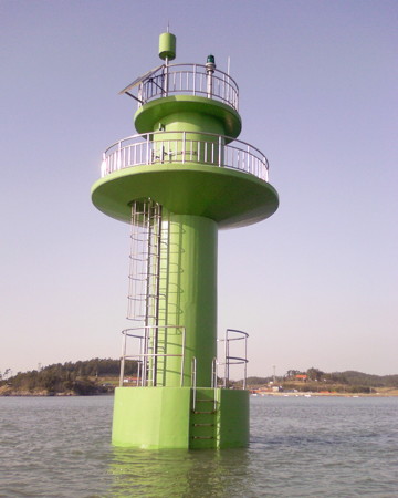
Date unknown. Active; focal plane 14 m (46 ft); green flash every 5 s. 10 m (33 ft) round cylindrical tower. Entire lighthouse is green. The Port of Mokpo's photo is at right, a distant drone view is available, and Google has a satellite view. Located on a reef off the harbor of Bokho, a small port at the southeastern end of Anjwado. Accessible only by boat. Site open, tower closed. KR-3069.5; Admiralty M4219.5; NGA 17615.
Jeungsando (Chungsando)
Date unknown. Active; focal plane 11 m (36 ft); white flash every 6 s. 8 m (26 ft) octagonal white concrete tower. Bing has a satellite view. Located on the northern tip of Jeungsando, an island off the southeast side of Anjwado. Site status unknown. Admiralty M4219; NGA 17617.
Daepotan (Taepo'o-t'an)
Date unknown. Active; focal plane 13 m (43 ft); three quick white flashes every 10 s. 10 m (33 ft) round concrete tower painted black with a red horizontal band. No photo available but Google has a satellite view. Located on a rock off the east coast of Jarado. Accessible only by boat. Site open, tower closed. Admiralty M4220.5; NGA 17616.5.
Jido (Chido)
Date unknown. Active; focal plane 28 m (92 ft); two white flashes every 6 s. 11 m (36 ft) round white concrete tower. No photo available but Google has a satellite view. Located atop a small island about 40 km (25 mi) southwest of Mokpo and 3 km (2 mi) southeast of Anjwado. Accessible only by boat. Site status unknown. KR-3064; Admiralty M4221; NGA 17614.
Bokhocho Light
Bokhocho Light, Anjwa
Port of Mokpo photo (no longer online)

Information available on lost lighthouses:

Notable faux lighthouses:

Adjoining pages: North: Northern Sinan Islands | Northeast: Mokpo Area | South: Jindo | Southwest: Heuksan Islands

Return to the Lighthouse Directory index | Ratings key

Posted January 9, 2008. Lighthouses: 39. Checked and revised May 8, 2024. Site copyright 2024 Russ Rowlett and the University of North Carolina at Chapel Hill.