Lighthouses of South Korea: Northern Sinan Islands

For most of its history Korea was an independent kingdom or at least an autonomous kingdom under Chinese influence. This came to an end in 1910, when Japan annexed all of Korea. At the end of World War II in 1945 the 38° parallel was established as the dividing line between U.S. and Soviet zones of occupation, and in 1948 separate civil administrations were established in the two halves of the country. The Korean War (1950-53) ended in a draw with the armistice line falling close to the prewar 38° line. The Republic of Korea (ROK), commonly called South Korea (Daehan Minguk in Korean) occupies the Korean peninsula south of the armistice line.

South Korea is divided into nine provinces and eight province-level cities; the provinces are subdivided into counties and cities. This page covers lighthouses in northern Sinan County, an island county of Jeollanam (South Jeolla) Province, located on South Korea's southwest coast in the region formerly known as Jeolla or Cholla. The county comprises a large archipelago west of Mokpo. Also included in the county are the Central Sinan Islands and the Heuksan Islands farther southwest.

In 2000 South Korea adopted a Revised Romanization System to replace systems formerly used in the West. In the Revised System, the word for a lighthouse is deungdae (등대); dan (formerly tan) is a cape, seom (som) or do (to) is an island, am or amseog is a rock, man is a bay, and hang is a harbor. Some place names may be more familiar to Westerners in the spellings of older systems.

Navigational aids in the ROK are regulated by the Ministry of Oceans and Fisheries (MOF). Lighthouses in Sinan are maintained by the Mokpo Regional Maritime Affairs and Port Authority.

ARLHS numbers are from the ARLHS World List of Lights. KR numbers, where available, are from the Korean light list. Admiralty numbers are from volume M of the Admiralty List of Lights & Fog Signals. U.S. NGA List numbers are from Publication 112.

General Sources
Port of Mokpo - Lighthouses
Photos and information in English for the major lighthouses of the area.
Lighthouses in South Korea
Photos available from Wikimedia.
Online List of Lights - Korea - Yellow Sea
Photos by various photographers posted by Alexander Trabas.
Navionics Charts
Navigation chart for the islands.


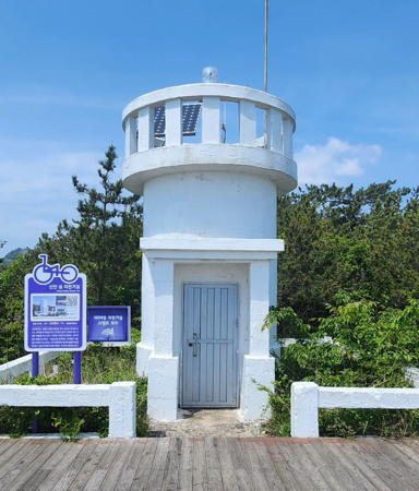
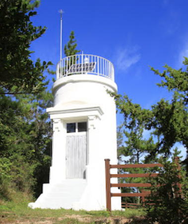
Palgeum Light, Palgeumdo, May 2024
Instagram photo by ksojune
Palgeum Township (Palgeumdo Area) Lighthouses
* Palgeumdo (P'algum Do)
1971. Active; focal plane 18 m (59 ft); white flash every 6 s. 6 m (20 ft) round white concrete tower. A 2024 photo is above, Kim Jeong-soon has a 2021 photo, another photo and a third photo (1/3 the way down the page) are available and Google has a satellite view. Located on the western tip of Palgeumdo, an island just to the northeast of Anjwado. Accessible by a hiking trail. Site open, tower closed. . KR-3124; Admiralty M4214; NGA 17664.
Amchido
Date unknown. Active; focal plane 12 m (39 ft); two white flashes every 5 s. 12 m (39 ft) round cylindrical tower with lantern and gallery, painted black with one red horizontal band. No photo available but Google has a satellite view. Located on a shoal off the northeastern tip of Maedo, an island northeast of Palgeumdo. Accessible only by boat. Site open, tower closed. KR-3123; Admiralty M4215.7; NGA 17633.
Hanapdeokdo (Hanapdokdo, Hanaptokto)
Date unknown. Active; focal plane 26 m (85 ft); white flash every 6 s. Approx. 10 m (33 ft) round white concrete tower. No photo available but Google has a satellite view. Located atop a small island off the northeastern tip of Palgeumdo. Accessible only by boat. Site open, tower closed. KR-3131; Admiralty M4215.5; NGA 17632.
Bulmugido (Pulmugi-do)
Active; focal plane 32 m (105 ft); white flash every 5 s. 11 m (36 ft) tapered square white concrete skeletal tower with gallery, painted white. A distant view (last photo on the page) is available and Google has a satellite view. This light has the same design as the Galdu Hang Light in southern Haenam (see the Mokpo Area page). Located on an island about 13 km (8 mi) west of Mokpo and 10 km (6 mi) southeast of Palgeumdo. Accessible only by boat. Site status unknown. KR-3078.5; Admiralty M4216.9; NGA 17621.

Amtae Township (Amtaedo Area) Lighthouse
Haeseo (Haeso)
Date unknown. Active; focal plane 8 m (26 ft); quick-flashing white light. 8 m (26 ft) round concrete tower, upper half painted black and lower half yellow. No photo available but Google has a satellite view. Located on a reef off the northeastern tip of Amtaedo. Accessible only by boat. Site open, tower closed. KR-3129; Admiralty M4216.2; NGA 17641.
Jaewando (Chaewon Do)
Date unknown. Active; focal plane 17 m (56 ft); two white flashes every 5 s. 10 m (33 ft) round concrete tower painted black with one red horizontal band. No photo available but Google has a satellite view. Located on a tiny island about 3 km (2 mi) east of the Haeseo Light. Accessible only by boat. Site open, tower closed. KR-3129.4; Admiralty M4216.1; NGA 17638.
* Amtaedo (Amtae Do)
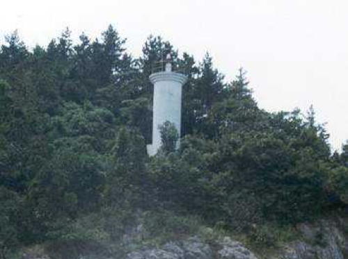
1913. Active; focal plane 38 m (125 ft); two white flashes every 5 s. 7 m (23 ft) round stucco-clad brick tower, painted white. Lantern removed. A photo is at right, J.G. Jeon has a closeup 2021 photo, several distant views are available, and the small tower can be seen in Google's satellite view. This is clearly a historic lighthouse, but we do not know anything of its history. Located at the eastern tip of Amtaedo, the largest island of the Sinan archipelago. Accessible by a hiking trail. Site open, tower closed. KR-3128; Admiralty M4216; NGA 17636.
Hwangdalseo
Date unknown. Active; focal plane 12 m (39 ft); six quick white flashes followed by one long white flash every 15 s. 15 m (49 ft) round concrete tower, upper half painted yellow and lower half black. A very distant drone view is available and Google has a satellite view. Located on a shoal about 2.5 km (1.5 mi) east of the Amtaedo lighthouse. Accessible only by boat. Site open, tower closed. KR-3129.1; Admiralty M4215.9.

Amtaedo Light, Amtaedo, September 2022
Google Maps photo by baeksun

Aphae Town (Aphaedo Area) Lighthouse
Hyojido
Date unknown. Active; focal plane about 15 m (49 ft); red light, pattern unknown. Approx. 15 m (49 ft) round concrete tower. Entire lighthouse is red. No photo available but Google has a satellite view. Located at a junction of north-south and east-west channels off the northeast tip of Aphaedo. Accessible only by boat. Site open, tower closed. KR-3078.3; Admiralty M4216.85.

Jaeun Township (Jaeundo Area) Lighthouses
Jinseomal (Chinso Mal)
Date unknown. Active; focal plane 60 m (197 ft); white flash every 5 s. 10 m (33 ft) round white concrete tower. No photo available but Google has a satellite view. Located on a promontory at the western tip of Jaeundo. Site status unknown. KR-3133; Admiralty M4211.5; NGA 17666.
Odo
Date unknown. Active; focal plane 72 m (236 ft); white flash every 4 s. 11 m (36 ft) round white concrete tower. No photo available but Google has a satellite view. Located on an isolated high island about 7 km (4 mi) northwest of Jaeundo. Accessible only by boat. Site status unknown. KR-3074; Admiralty M4211; NGA 17644.
Jaeundo (Chaun Do)
Date unknown. Active; focal plane 34 m (112 ft); two white flashes every 6 s. 9 m (30 ft) round cylindrical white concrete tower. A photo is at right and Google has a distant satellite view. Located on a promontory at the northeastern tip of Jaeundo. Site status unknown. KR-3073; Admiralty M4216.5; NGA 17640.
Jinmokdo
Date unknown. Active; focal plane 11 m (36 ft); three quick white flashes every 10 s. 13 m (43 ft) round concrete tower, painted black with one yellow horizontal band. No photo available but Google has a satellite view. Located on a shoal off the east coast of Jaeundo. Accessible only by boat. Site open, tower closed. KR-3073.1; Admiralty M4216.3.

Jaeundo Light, Jaeundo, posted January 2016
Librewiki.net Creative Commons photo

Jeungdo Township Lighthouses
Oegaldo (Oegalto)
Date unknown. Active; focal plane 33 m (108 ft); white flash every 5 s. 8 m (26 ft) round white concrete tower. No photo available but Google has a satellite view. Located on a small island off the southwestern tip of Jeungdo. Accessible only by boat. Site status unknown. KR-3075; Admiralty M4210.8; NGA 17643.1.
Sinan Byeongpungdo
Date unknown. Active; focal plane 9 m (30 ft); two white flashes every 5 s. 11 m (36 ft) round concrete tower, painted black with one red horizontal band. No photo available but Google has a satellite view. Located on a reef in the passage off the east coast of Jeungdo. Accessible only by boat. Site open, tower closed. Admiralty M4216.8; NGA 17643.5.
Soakdo
Date unknown. Active; focal plane 12 m (39 ft); nine quick white flashes every 15 s. 11 m (36 ft) round concrete tower, painted yellow with one black horizontal band. No photo available but Google has a satellite view. Located on a skerry in the passage on the east side of Jeungdo. Accessible only by boat. Site open, tower closed. KR-3133.1; Admiralty M4216.6; NGA 17639.
Hwangdo (Bigyeoseom)
Date unknown. Active; focal plane 33 m (108 ft); white flash every 6 s. 11 m (36 ft) round white concrete tower. No photo available but Google has a satellite view. Located at the western end of a small island south of Jeungdo, marking the northern approach to Mokpo, about 30 km (19 mi) northwest of the city. Accessible only by boat. Site status unknown. KR-3076; Admiralty M4216.7; NGA 17642.

Imja Township Lighthouses
Jasonyeo
Date unknown. Active; focal plane 19 m (62 ft); quick-flashing white light. 11 m (36 ft) round concrete tower, upper half painted black and lower half yellow. No photo available but Bing has a satellite view. Located on a skerry about 20 km (13 mi) west southwest of Imjado. Accessible only by boat. Site status unknown. KR-3074.5; Admiralty M4211.2; NGA 17644.2.
Sobichido
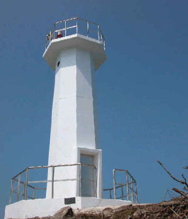
Date unknown. Active; focal plane 94 m (308 ft); white flash every 6 s. 10 m (33 ft) octagonal white concrete tower. A photo is at right and Bing has a satellite view. Located at the northwestern end of a small island about 20 km (13 mi) northwest of Imjado. Accessible only by boat. Site status unknown. KR-3137.4; Admiralty M4210.2.
Sobichido Light
Sobichido Light, Imja
Port of Mokpo photo (no longer online)
Daenorokdo (Daerorogso, Taerorok To)
Date unknown. Active; focal plane 72 m (236 ft); white flash every 5 s. 7 m (23 ft) round white concrete tower. No photo available but Google has a distant satellite view. Located on an island about 8 km (5 mi) west of Imjado. Accessible only by boat. Site status unknown. KR-3135; Admiralty M4210; NGA 17712.
Sambongdan (Sambong)
Date unknown. Active; focal plane 31 m (102 ft); white flash every 4 s. 10 m (33 ft) round white concrete tower. No photo available but Google has an indistinct satellite view. Located on a sharp promontory at the northeastern tip of Imjado. Accessible only by boat. Site status unknown. KR-3136; Admiralty M4210.3; NGA 17714.
Jeonjangpo
2007. Active; focal plane 11 m (36 ft); two white flashes every 5 s. 16 m (52 ft) round concrete tower, painted black with one red horizontal band. No photo available but Google has a satellite view and a very distant street view from the waterfront of Dochan. Located on a shoal off the waterfront of Jeonjangpo, about 1.6 km (1 mi) southwest of the Sambongdan lighthouse. Accessible only by boat. Site open, tower closed. KR-3136.5; Admiralty M4210.25; NGA 17715.
Sudo Southeast
2006. Active; focal plane 13 m (43 ft); white flash every 6 s. 11 m (36 ft) octagonal white concrete tower standing on a broad octagonal concrete base. Jeong Jong-il has a 2019 photo and a distant view, Google has a satellite view. Sudo is an island in the passage between Imjado on the west and Haejedo on the east. Located on the southeastern tip of the island. Site status unknown. KR-3138.10; Admiralty M4210.38.
Sudo Southwest
2006. Active; focal plane 10 m (33 ft); green flash every 5 s. 15 m (49 ft) round green concrete tower. No photo available but Gogle has a satellite view. This light was relocated around 2020, probaably in connection with a change in the channel under the bridge a short distance to the north. Located off the southwestern tip of the island guiding vessels in the channel between Sudo and Imjado. Site status unknown. KR-3138.21; Admiralty M4210.37.

Jido Town Lighthouses
Bongri
2004. Active; focal plane 14 m (46 ft); white flash every 6 s. 11 m (36 ft) octagonal white concrete tower standing on a broad octagonal concrete base. No photo available but Google has a satellite view. Located on a small island off the northwestern coast of Haejedo. Accessible only by boat. Site open, tower closed. KR-3135.5; Admiralty M4210.35.
Naedo
Date unknown. Active; focal plane 5 m (16 ft); nine quick white flashes every 15 s. 5 m (16 ft) round concrete tower painted yellow with one black horizontal band. No photo available but Google has a satellite view and a very distant street view. The tower appears taller than the listed height in satellite views. Located in a reef in the channel between Saokdo and Jido. Accessible only by boat. Site open, tower closed. Admiralty M4210.5; NGA 17713.
Oegyodo
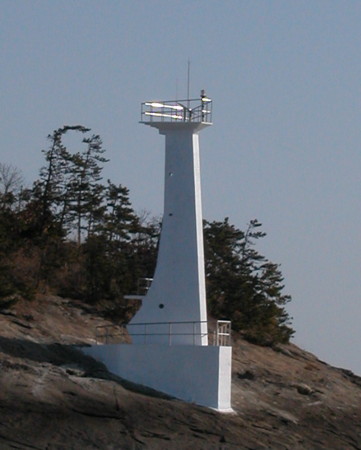
Date unknown. Active; focal plane 19 m (62 ft); white flash every 4 s. 15 m (49 ft) white concrete tower. A photo is at right and Google has a satellite view. Located on Oegyodo, a small island off Dangchong village, about 8 km (5 mi) southwest of Jido. Accessible only by boat. Site open, tower closed. KR-3075.3; Admiralty M4210.7.
Oegyodo Light
Oegyodo Light, Jido
Port of Mokpo photo (no longer online)

Information available on lost lighthouses:

Notable faux lighthouses:

Adjoining pages: North: Gochang and Buan | East: Mokpo Area | South: Central Sinan Islands

Return to the Lighthouse Directory index | Ratings key

Posted January 9, 2008. Lighthouses: 27. Checked and revised May 16, 2024. Site copyright 2024 Russ Rowlett and the University of North Carolina at Chapel Hill.