Lighthouses of South Korea: Boryeong (Daecheon) Area

For most of its history Korea was an independent kingdom, or at least an autonomous kingdom under Chinese influence. This came to an end in 1910 when Japan annexed all of Korea. At the end of World War II in 1945 the 38° parallel was established as the dividing line between U.S. and Soviet zones of occupation, and in 1948 separate civil administrations were established in the two halves of the country. The Korean War (1950-53) ended in a draw with the armistice line falling close to the prewar 38° line. The Republic of Korea (ROK), commonly called South Korea (Daehan Minguk in Korean), occupies the Korean peninsula south of the armistice line.

South Korea is divided into nine provinces and eight province-level cities; the provinces are subdivided into counties and cities. This page covers lighthouses of southern Chungcheongnam (Chungnam) province on South Korea's west coast, including the metropolitan city of Boryeong (Daecheon), Hongseong County, and the southern end of Seosan City. This coast faces west on the Yellow Sea (known in Korea as the West Sea). By Korean standards it is a relatively low coast, with a number of islands offshore. There are no major ports in the region, although Daecheon is a traditional fishing port.

In 2000 South Korea adopted a Revised Romanization System to replace systems formerly used in the West. In the Revised System, the word for a lighthouse is deungdae (등대); dan (formerly tan) is a cape, seom (som) or do (to) is an island, am or amseog is a rock, man is a bay, and hang is a harbor. Some place names may be more familiar to Westerners in the spellings of older systems.

Navigational aids in the ROK are regulated by the Ministry of Oceans and Fisheries (MOF). In the Boryeong area, the lights are maintained by the Gunsan Regional Oceans and Fisheries Administration.

ARLHS numbers are from the ARLHS World List of Lights. Admiralty numbers are from volume M of the Admiralty List of Lights & Fog Signals. U.S. NGA

General Sources
Online List of Lights - Korea - Yellow Sea
Photos by various photographers posted by Alexander Trabas.
Navigational Beacon Management Office
Information from the Gunsan Oceans and Fisheries Office.
Navionics Charts
Navigation chart for western South Korea.
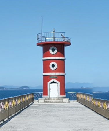


Hodo Hang Light, Boryeong, June 2017
Google Maps street view by Sangpil Lee
Boryeong (Daecheon) City: Ocheon Township Lighthouses

The Ocheon Township includes several groups of islands in the Yellow Sea west and southwest of Daecheon.

Oeyeondo Village Lighthouses
Oeyeondo is a group of small islands about 30 km (19 mi) to the west of Daecheon. Popular as an adventure resort, the islands have been declared a natural monument.
* Oeyeondo East Breakwater
Date unknown. Active; focal plane 13 m (43 ft); red flash every 4 s. 10 m (33 ft) round concrete tower, painted red. Kim Il-un's closeup 2024 photo is at right, Park Joon-su has a 2018 view of the two breakwater lights, Dong Kim has a 2021 drone view, and Google has a satellite view. Oeyeondo is the largest of a group of small islands about 50 km (30 mi) west of Boryeong. Located at the end of the east breakwater of Oeyeondo. Probably accessible by walking the pier. Site open, tower closed. KR-3238; Admiralty M4189.5; NGA 17820.
* Oeyeondo West Breakwater (2)
2023. Active; focal plane 17 m (56 ft); two green flashes every 6 s. 10 m (33 ft) round concrete tower, painted white. This breakwater was being extended in 2022. The new lighthouse at the extended end was announced in December 2023. Kim Il-un has a 2024 photo of both breakwater lighthouses but the light does not appear yet in Google's satellite view. A photo is at right, Park Joon-su's 2018 view of the two breakwater lights and Dong Kim's 2021 drone view show the original light. Located at the end of the west (main) breakwater of Oeyeondo. Probably accessible by walking the pier. Site open, tower closed. KR-3237; Admiralty M4189.55; NGA 17821.
Bulando (Pulando)
Date unknown. Active; focal plane 61 m (200 ft); white flash every 6 s. 8.5 m (28 ft) round white concrete tower. No photo available but Google has an indistinct satellite view. Located on an island off the southeastern end of Oeyeondo. Accessible only by boat. Site status unknown. KR-3240; Admiralty M4189.6; NGA 17825.
Chomangseo
2011. Active; focal plane 15 m (49 ft); two white flashes every 10 s. 18 m (59 ft) round cylindrical concrete tower, mounted on a round concrete pier. Lighthouse painted black with one red horizontal band. No photo available but Google has a satellite view. Located on a reef about 3 km (1.8 mi) south of Oeyando. Accessible only by boat. Site open, tower closed. KR-3237.1; Admiralty M4189.59.
Oebeomhyeonseo
2007. Active; focal plane 14 m (46 ft); two white flashes every 10 s. 14 m (46 ft) round cylindrical concrete tower, mounted on a round concrete pier. Lighthouse painted black with one red horizontal band. A photo is available (3/4 the way down the page) and Google has a satellite view. Located about 600 m (0.4 mi) southwest of the southern point of Oeyeondo. Accessible only by boat. Site open, tower closed. KR-3236.7; Admiralty M4189.58.
Oehoenggyeondo
Date unknown. Active; focal plane about 14 m (46 ft); six quick white flashes followed by one long white flash every 15 s. Approx. 10 m (33 ft) round cylindrical concrete tower, upper half painted yellow and lower half black. No photo available but Google has a satellite view. Located on a reef in a narrow passage about 3 km (1.8 mi) southwest of the western point of Oeyeondo. Accessible only by boat. Site open, tower closed. KR-3237.2; Admiralty M4189.57.

East Breakwater Light, Oeyeondo, June 2024
Google Maps photo by Kim Il-un

Nokdo Village Lighthouses
This village includes a group of small islands west of Daecheon and halfway between the Oeyeondo and Sapsido islands. Hodo and Nokdo are the principal islands of the group.

Daegilsando
2003. Active; focal plane 118 m (387 ft); white flash every 6 s. 12 m (39 ft) round white concrete tower. No photo available. Google's satellite view is obscured by clouds but the light is seen in Bing's indistinct satellite view. Located atop an island about 15 km (9 mi) northeast of the Oeyeondo group and at the western end of the Nokdo group. Accessible only by boat. Site status unknown. KR-3241.7; Admiralty M4189.75.
Otakseo (2?)
2008. Active; focal plane 17 m (56 ft); two white flashes every 5 s. 21 m (69 ft) concrete tower, painted black with a red horizontal band. No photo available and the light is not seen in Google's satellite view. In February 2024 a Korean notice to mariners described what appears to be a new, taller tower. Located on a reef about 16 km (10 mi) northwest of Nokdo. Accessible only by boat. Site open, tower closed. KR-3243.1; Admiralty M4189.735; NGA 17831.5.
Heukseo
2014. Active; focal plane 36 m (118 ft); nine quick white flashes every 15 s. 13 m (43 ft) round cylindrical concrete tower, painted yellow with one black horizontal band. Eunyong Park has a view from the sea and Google has an indistinct satellite view. Located on a rocky reef off the west coast of Hodo, the northernmost major island of the Nokdo group. Accessible only by boat. Site open, tower closed. KR-3243.3; Admiralty M4189.741.
* Hodo Hang
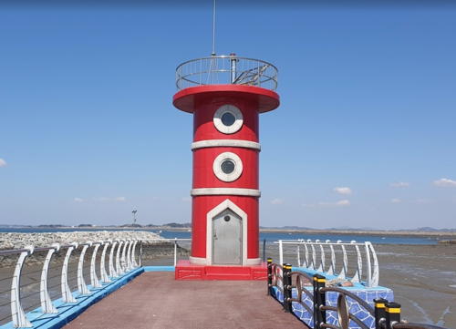
Date unknown. Active; focal plane 13 m (43 ft); red flash every 6 s. Approx. 9 m (30 ft) round concrete tower painted red with white trim. A portion of Sangpil Lee's street view is at the top of this page, a 2023 photo is available, and Google has a distant satellite view. Located at the end of the breakwater at Hodo harbor, at the north end of Hodo Island. Accessible by walking the pier. Site open, tower closed. Admiralty M4189.732.
Nokdo Approach
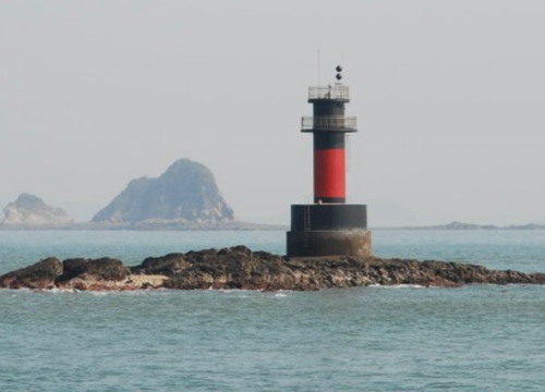
Date unknown. Active (?); focal plane 17 m (56 ft); two white flashes every 5 s. 21 m (69 ft) round cylindrical concrete tower, mounted on a round concrete pier. Lighthouse painted black with one red horizontal band. A photo is at right and Google has a satellite view. Although this light disappeared from the Admiralty list it has continued to be charted by Navionics. Located off the northern tip of Nokdo, an island halfway between Daecheon and Oryeongdo. Accessible only by boat. Site open, tower closed. ex-Admiralty M4189.73.

Nokdo Approach Light, October 2009
blog.naver.com Creative Commons photo by hwas3
* Nokdo North Breakwater
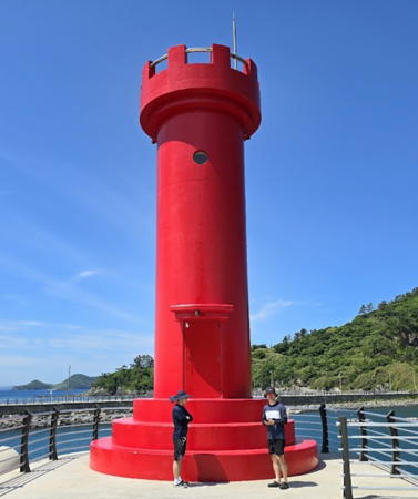
Date unknown. Active; focal plane 13 m (43 ft); red flash every 6 s. 11 m (36 ft) round concrete tower. Entire lighthouse is red. A photo is at right, another view of both Nokdo breakwater lights is available, Yunsu Eoh has a distant 2019 view, and Google has a satellite view. Located on the north breakwater of Nokdo harbor. Accessible by walking the pier. Site open, tower closed. KR-3241; Admiralty M4189.69.
* Nokdo South Breakwater
Date unknown. Active; focal plane 17 m (56 ft); green flash every 6 s. 11 m (36 ft) round concrete tower. Entire lighthouse is white. A photo is at right, Jeon Jae Byeong has a photo and also a photo of the two lights, another view of both Nokdo breakwater lights is available, Yunsu Eoh has a distant 2019 view, and Google has a satellite view. Located on the south breakwater of Nokdo harbor. Accessible by walking the pier. Site open, tower closed. KR-3241.1; Admiralty M4189.7; NGA 17828.
Chudo South
2005. Active; focal plane 10 m (33 ft); six quick white flashes followed by one long white flash every 15 s. 17 m (56 ft) round cylindrical concrete tower, mounted on a round concrete pier. Upper half of the lighthouse painted yellow, lower half black. No photo available but Google has a satellite view. Located off the southeast coast of a small island about 3 km (2 mi) northeast of Nokdo. Accessible only by boat. Site open, tower closed. KR-3243.9; Admiralty M4189.74; NGA 17829.
Hahongseo
2001. Active; focal plane 14 m (46 ft); two white flashes every 10 s. 16 m (52 ft) round cylindrical concrete tower, mounted on a round concrete pier. Lighthouse painted black with one red horizontal band. No photo available and the light is not shown in Google's satellite view. Located on a rocky reef about 7 km (4.5 mi) east of Nokdo. Accessible only by boat. Site open, tower closed. KR-3241.5; Admiralty M4189.625.
Nokdo Breakwater Lights
Nokdo North (left) and South Breakwater Lights, October 2012
ex-Daum.net Creative Commons photo by 금모래은
Sanghongseo
2008. Active; focal plane 15 m (49 ft); two white flashes every 5 s. 22 m (72 ft) concrete tower, painted black with a red horizontal band. No photo available and the tower is not seen in Bing's satellite view. Located on a reef about 8 km (5 mi) northeast of Daehwasado. Accessible only by boat. Site open, tower closed. KR-3241.6; Admiralty M4189.63; NGA 17831.
Daehwasado (Taehwasado)
2006. Active; focal plane 101 m (331 ft); white flash every 10 s. 11 m (36 ft) square concrete tower, painted white. No photo available but Google has an indistinct satellite view. Daehwasado is the southernmost island of the Nokdo group, about 3 km (2 mi) southeast of Nokdo; it is uninhabited and lacks landing facilities so it is rarely visited. Located at the highest point of the island. Accessible only by boat. Site status unknown. KR-3239; Admiralty M4189.8; NGA 17830.
Juseo
Date unknown. Active; focal plane about 14 m (46 ft); nine quick white flashes every 15 s. Approx. 14 m (46 ft) round concrete tower painted yellow with a black horizontal band. No photo available but Google has a satellite view. Located on the west end of a shoal off the southern tip of Daehwasado. Accessible only by boat. Site status unknown. KR-3238.1; Admiralty M4189.78.
Nokodo
Date unknown. Active; focal plane 20 m (66 ft); four yellow flashes every 8 s. 20 m (66 ft) robust steel post. No photo available and the light is not seen in Google's satellite view. This light has an isolated location about 8 km (5 mi) southwest of Juseo and 20 km (13 mi) east of Oeyeondo. Accessible only by boat. Site open, tower closed. KR-3240.1; Admiralty M4189.77.

Sapsido Village Lighthouses
These islands lie northwest of Saecheon and southwest of the much larger island of Anmyeondo in Taean County. Sapsido is the principal island; Godaedo and Janggodo are smaller islands north of Sapsido and west of Wonsando.

* Janggodo Hang Breakwater
Date unknown. Active; focal plane 8 m (26 ft); green flash every 4 s. 6 m (20 ft) round cylindrical concrete tower. Entire lighthouse is white. A distant view is available, and Google has a distant satellite view. Located on the main breakwater of the harbor of Janggodo. Accessible by walking the pier. Site open, tower closed. KR-3246; Admiralty M4185.1; NGA 17827.5.
* Godaedo Hang Breakwater
Date unknown. Active; focal plane 13 m (43 ft); red flash every 6 s. 11 m (36 ft) round cylindrical concrete tower. Entire lighthouse is red. Taehoon Lee's photo is at right, Kim Gun has a distant view, and Google has a satellite view. Located on a long breakwater at the northern end of Godaedo, an island north of Sapsido. Accessible by walking the pier. Site open, tower closed. KR-3242; Admiralty M4185.08; NGA 17827.
Sapsido North
Date unknown. Active; focal plane 14 m (46 ft); red flash every 5 s. 19 m (59 ft) round cylindrical concrete tower, painted red. No photo available but Bing has a satellite view. Located on a shoal in the passage between Sapsido and Godaedo. Accessible only by boat. Site open, tower closed. KR-3243; Admiralty M4185.6; NGA 17827.7.
* [Sapsido Hang Breakwater]
Date unknown. Active; focal plane 18 m (59 ft); green flash every 6 s. 9 m (30 ft) white steel post rising from a small equipment shelter. Sungdo Ahn has a 2022 photo and Google has a satellite view. Loacted on the south (main) breakwater of Sapsido harbor. Accessible by walking the pier. Site open, tower closed. KR-3242.1; Admiralty M4185.7.
Napjakdo (Bapjakdo) North
2005. Active; focal plane 9 m (30 ft); two white flashes every 5 s. 16 m (52 ft) round cylindrical concrete tower, mounted on a round concrete pier. Lighthouse painted black with one red horizontal band. No photo available but Google has an indistinct satellite view. Located on a rocky reef about 2 km (1.25 mi) east of Sapsido. Accessible only by boat. Site open, tower closed. KR-3244.1; Admiralty M4185.8; NGA 17827.8.
Yongdo North
2012. Active; focal plane 16 m (52 ft); white flash every 5 s. 18 m (59 ft) round cylindrical concrete tower, mounted on a round concrete pier. Lighthouse painted black with one red horizontal band. No photo available and the tower is not seen in Bing's satellite view. Located on a shoal about 5 km (3 mi) south southeast of Sapsido. Accessible only by boat. Site open, tower closed. KR-3241.8; Admiralty M4189.67.

Godaedo Hang Light, Sapsido, June 2017
Google Maps photo by Taehoon Lee

Wonsando Village Lighthouses
Oejukdo
2003. Active; focal plane 17 m (56 ft); red flash every 4 s. 19 m (59 ft) tower, painted red. Eunyong Park has a distant view and Google has a satellite view. Located on a rock about 3 km (2 mi) southeast of Gonam. Accessible only by boat. Site open, tower closed. KR-3275; Admiralty M4185.14; NGA 17839.
* Wonsando Hang North Breakwater
Date unknown. Active; focal plane 14 m (46 ft); red flash every 5 s. 10 m (33 ft) octagonal cylindrical concrete tower. Entire lighthouse is red. A 2020 photo is at right, Kim Jong-gil has a 2022 street view, and Google has a satellite view. Wonsando is an island about 8 km (5 mi) west northwest of Daecheon harbor. Located on the north breakwater of Wonsando harbor. Accessible by walking the pier. Site open, tower closed. KR-3275.3; Admiralty M4185.12.

Hyojado Village Lighthouses
* Hyojado Hang
Date unknown. Active; focal plane 7.5 m (25 ft); green flash every 4 s. Approx. 6 m (20 ft) round green steel tower. No photo available but Google has an indistinct satellite view. KHOA describes this as a "steel pipe," but the satellite view suggests a more robust tower. Located on the pier on the southwest coast of Hyojado. Probably accessible by walking the pier. Site open, tower closed. KR-3275,4; Admiralty M4185.11.
Ganseo
Date unknown. Active; focal plane about 14 m (46 ft); red flash every 5 s. Approx. 12 m (39 ft) concrete tower. Lighthouse painted black with one red horizontal band. The light is near the left edge in Eunyong Park's distant viewof the Oejukdo Light and Bing has a satellite view. Located on a reef north of Hyajado, a small island east of Wonsando. Accessible only by boat. Site open, tower closed. Admiralty M4185.15; NGA 17839.2.
Mokdo
Date unknown. Active; focal plane about 14 m (46 ft); three quick white flashes every 10 s. Approx. 14 m (46 ft) concrete tower. Lighthouse painted black with one yellow horizontal band. No photo available but Google has a satellite view. Located on a reef about 1 km (0.6 mi) off the industrial piers of Gocheong, north of Boryeong. Accessible only by boat. Site open, tower closed. KR-3279; Admiralty M4185.2.

North Breakwater Light, Wonsando, August 2020
Google Maps photo by Janggundangjin

Boryeong (Daecheon) City: Mainland Lighthouses

The metropolitan city of Boryeong was formed by merging the former city of Daecheon with the surrounding Boryeong County. Although the name chosen for the expanded city is Boryeong it is still called Daecheon by most of its 110,000 residents.

Ungcheo Township Lighthouses
Seokdaedo
Date unknown. Active; focal plane 19 m (62 ft); nine quick white flashes every 15 s. 20 m (66 ft) round cylindrical concrete tower painted yellow with one black horizontal band. No closeup photo available. The light is just to the left of the island at the right edge of a 2022 view and Google has a satellite view. Located on a reef about 3.25 km (2 mi) southwest of the Muchangpo harbor entrance. Accessible only by boat. Site open, tower closed. KR-3259.2; Admiralty M4187.45.
* Muchangpo Hang South Breakwater
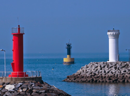
Date unknown. Active; focal plane 16 m (52 ft); red flash every 6 s. 11 m (36 ft) round concrete tower, painted red. This light is on the left in Kim Ho Gyeong's photo at right, Daehoon Kim has a 2023 closeup, Chae Sang Hun has a street view, and Google has a satellite view. Located at the end of the south breakwater of Muchangpo. Accessible by walking the pier. Site open, tower closed. KR-3244; Admiralty M4187.3; NGA 17826.
* Muchangpo Hang North (Outer) Breakwater
Date unknown. Active; focal plane 13 m (43 ft); green flash every 6 s. 11 m (36 ft) round concrete tower. Entire lighthouse is white. This light is on the right in Kim Ho Gyeong's photo at right, Chae Sang Hun has a street view, and Google has a satellite view. Located at the end of the north breakwater of Muchangpo. Accessible by walking the pier. Site open, tower closed. KR-3244.7; Admiralty M4187.35.
Muchangpo Hang
2005. Active; focal plane 16 m (52 ft); quick-flashing white light. Approx. 14 m (46 ft) round cylindrical concrete tower mounted on a round concrete pier. Upper half of the lighthouse painted black, lower half yellow. This light is in the center in Kim Ho Gyeong's photo at right, Chae Sang Hun has a street view, and Google has a distant satellite view. Located on a reef about 500 m (0.3 mi) west of the Muchangpo harbor entrance. Accessible only by boat but easily seen from the harbor. Site open, tower closed. KR-3243.10; Admiralty M4187.4; NGA 17825.9.

Muchangpo Hang Lighthouses, April 2015
ex-Google Plus photo by Kim Ho Gyeong

Daecheon Harbor Lighthouses
Sonyeam (Sonyeoam, Soyeo Am)
Date unknown. Active; focal plane 11 m (36 ft); red flash every 4 s. 17 m (56 ft) round concrete tower, painted red. No photo available and the light is not seen in Bing's satellite view. Located on a reef about 5 km (3 mi) west southwest of Daecheon harbor. Accessible only by boat. Site open, tower closed. KR-3263; Admiralty M4187; NGA 17832.
* Daecheon (Taech'on) Hang West Breakwater
Date unknown. Active; focal plane 17 m (56 ft); red flash every 6 s. 10 m (33 ft) round concrete tower, painted red. Kim Jeyeong's photo is at right, additional photos (first and second photos on the page) are available, Kyung-wook Lee has a 2018 closeup, Dukgun Yun has a 2022 closeup, Jongsik Lee has a 2019 photo, Hyunseok Moon has a 2022 street view, and Google has a satellite view. Located at the end of the west breakwater of Daecheon. Accessible by walking the pier. Site open, tower closed. KR-3267; Admiralty M4186; NGA 17836.
Daecheon (Taech'on) Hang North Breakwater West Head
Date unknown. Active; focal plane 12 m (39 ft); green flash every 5 s. 8 m (26 ft) hexagonal concrete tower. Entire lighthouse is white. Yunji Kim has a 2018 photo, another photo (2/3 the way down the page) is available, and Google has a satellite view. Located at the west end of a detached breakwater at Daecheon. Accessible only by boat. Site status unknown. KR-3277; Admiralty M4186.2; NGA 17838.
Daecheon (Taech'on) Hang North Breakwater East Head (2)
Date unknown. Active; focal plane 15 m (49 ft); red flash every 6 s. 13 m (43 ft) square metal tower. Entire lighthouse is red. A very distant view by Kim Jeyeong is available, Hyunseok Moon has a very distant 2022 street view, and Google has a satellite view. NGA lists a round tower at this location. Located at the east end of a detached breakwater at Daecheon. Accessible only by boat. Site status unknown. KR-3277.2; Admiralty M4186.3.


Daecheon West Breakwatr Light, Boryeong, October 2017
Google Maps photo by Kim Jeyeong

Note: The remaining lights on this page are on the east side of Cheonsu Bay, a long south-to-north inlet that separates the mainland from the large island of Anmyeondo. Lights of Anmyeondo are described on the Taean page.

Hongseong County Lighthouses

Seobu Township Lighthouses
Cheonsuman (Cheonsu Man, Geomeunyeo)
2020. Active; focal plane 19 m (59 ft); three quick white flashes every 10 s. 19 m (59 ft) round cylindrical concrete tower painted black with one red horizontal band. No photo available but Google has a satellite view. The light marks a long shoal in the center of Cheonsu Bay. Located about 4 km (2.5 mi) southwest of Namdang. Accessible only by boat. Site open, tower closed. KR-3284.3; Admiralty M4185.45.
* Jukdo (Jugdo) Hang
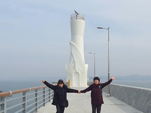
Date unknown. Active; focal plane 24 m (79 ft); green flash every 4 s. Approx. 19 m (62 ft) white hourglass-shaped concrete tower, surrounded by sculpture. Taekwon Kwon's 2023 photo is at right, Youngoh Cho has a 2022 photo, and Google has a satellite view. Located on the south breakwater of the harbor at Jukdo, a small island in the center of Cheonsu Bay. Accessible by walking pier. Site open, tower closed. KR-3285; Admiralty M4185.48.

Jukdo Hang Light, Seobu, February 2023
Google Maps photo by Taekwon Kwon
 
* Namdang Hang (2)
2020 (station establishment date unknown). Active; focal plane 13.5 m (44 ft); two green flashes every 6 s. 12 m (39 ft) square white skeletal tower with lantern and gallery. Lee Jeonghun has a closeup 2022 photo, Yeonmin Jeong has a photo of the new lighthouse, Sooho Jo has a very distant 2023 street view, and Google has a satellite view. The original light was on a round concrete tower. Located on the breakwater at Namdang, a small fishing port on Cheonsu Bay. Accessible by walking the pier. Site open, tower closed. KR-3286; Admiralty M4185.5.
* Gungni (Gungri) Hang
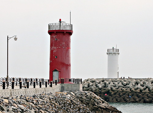
Date unknown. Active; focal plane 18 m (59 ft); red flash every 6 s. 8 m (26 ft) round cylindrical concrete tower painted red with white trim. A photo is at right, Gil Pyeong-hee also has a photo, and Google has a satellite view. Located on the breakwater at Gungni, a small boat harbor near the head of Cheonsu Bay. Accessible by walking the pier. Site open, tower closed. KR-3286.3; Admiralty M4185.58.

Southern Seosan City Lighthouse

Buseok Township Lighthouse
* Ganwoldo Hang
Date unknown. Active; focal plane 18 m (59 ft); red flash every 6 s. 8 m (26 ft) round tapered concrete tower painted red. Seung Joon Lee has a 2021 photo, Yaho Du has a 2024 photo, Kim Yeong Been has a view from shore, and Google has a satellite view. Located on the breakwater at Ganwoldo, a small boat harbor at the head of Cheonsu Bay. Accessible by walking the pier. Site open, tower closed. KR-3287.32; Admiralty M4184.413.

Gungni Hang Light, Seobu, March 2019
Google Maps photo by 아울보니OwlBonny

Information available on lost lighthouses:

Notable faux lighthouses:

Adjoining pages: North: Taean | South: Gunsan Area | Southwest: Okdo Islands

Return to the Lighthouse Directory index | Ratings key

Posted February 4, 2008. Checked and revised June 16, 2024. Lighthouses: 42. Site copyright 2024 Russ Rowlett and the University of North Carolina at Chapel Hill.