Lighthouses of South Korea: Taean

by For most of its history Korea was an independent kingdom, or at least an autonomous kingdom under Chinese influence. This came to an end in 1910 when Japan annexed all of Korea. At the end of World War II in 1945 the 38° parallel was established as the dividing line between U.S. and Soviet zones of occupation, and in 1948 separate civil administrations were established in the two halves of the country. The Korean War (1950-53) ended in a draw with the armistice line falling close to the prewar 38° line. The Republic of Korea (ROK), commonly called South Korea (Daehan Minguk in Korean), occupies the Korean peninsula south of the armistice line.

South Korea is divided into nine provinces and eight province-level cities; the provinces are subdivided into counties and cities. This page covers lighthouses of Taean County in central Chungcheongnam (Chungnam, South Chungcheong) province on South Korea's west coast. Taean has a very scenic coast facing west on the West Sea (Yellow Sea), with a number of high islands scattered offshore. Much of the coastal region is included in the Taean Haean National Park.

In 2000 South Korea adopted a Revised Romanization System to replace systems formerly used in the West. In the Revised System, the word for a lighthouse is deungdae (등대); dan (formerly tan) is a cape, seom (som) or do (to) is an island, am or amseog is a rock, man is a bay, and hang is a harbor. Some place names may be more familiar to Westerners in the spellings of older systems.

Navigational aids in the ROK are regulated by the Ministry of Oceans and Fisheries (MOF). In Taean the lights are maintained by the Daesan Regional Oceans and Fisheries Administration. In Korean, the word for a lighthouse is deungdae (등대); dan is a cape, do is an island, and hang is a harbor .

ARLHS numbers are from the ARLHS World List of Lights. KR numbers, where available, are from the Korean light list. Admiralty numbers are from volume M of the Admiralty List of Lights & Fog Signals. U.S. NGA List numbers are from Publication 112.

General Sources
Online List of Lights - Korea - Yellow Sea
Photos by various photographers posted by Alexander Trabas.
Navionics Charts
Navigation chart for the Taean area.


Ongdo Light, Geunheung, August 2019
Google Maps photo by Lee Young-min
Gonam Township Lighthouses
Gonam occupies the southern tip of the large island of Anmyeondo, separated by a narrow strait from the island of Wonsando in Boryeong City. The strait is crossed by a bridge.

Janggodo South
Date unknown. Active; focal plane about 15 m (49 ft); quick-flashing white light. Approx. 15 m (49 ft) tower, upper half painted black, lower half yellow. A distant view is available and Google has a satellite view. Located on a reef about 800 m (1/2 mi) off Gumae, a small port on the southeast coast of the island of Anmyeondo. Accessible only by boat. Site open, tower closed. KR-3279.9; Admiralty M4185.18.
Oejanggodo
2008. Active; focal plane 17 m (56 ft); two white flashes every 10 s. 15 m (49 ft) tower, painted black with one red horizontal band. A distant view is available (about 2/3 the way down the page) and Google has an indistinct satellite view. Located on a rock off the southwest coast of the island of Anmyeondo about 5 km (3 mi) west of Gonam. Accessible only by boat. Site open, tower closed. KR-3286.7; Admiralty M4185.105; NGA 17827.1.

Anmyeon Town Lighthouses
Anmyeon occupies most of the island of Anmyeondo, separated from the rest of Taean County by a narrow channel.
Oedo
2001. Active; focal plane 52 m (171 ft); white flash every 6 s. 12 m (39 ft) round cylindrical white concrete tower. Entire lighthouse is white. A distant view is available and Google has a satellite view. Located atop a small island about 3 km (1.8 mi) off the southwestern coast of Anmyeondo. Accessible only by boat. Site status unknown. KR-3287.9; Admiralty M4184.45; NGA 17827.15.
Bangpo
Date unknown. Active; focal plane 19 m (62 ft); two white flashes every 5 s. 19 m (62 ft) round cylindrical concrete tower, painted black with a red horizontal band, mounted on a round concrete pier. A 2009 photo is available, Jongmyeong Lee has a photo, a more distant 2016 view is available, Jeasung Park has a distant street view, and Google has a satellite view. Located on a reef off Bangpo harbor. Accessible only by boat, but easy to see from shore. Site open, tower closed. KR-3287.10; Admiralty M4184.48.
* Bangpo Breakwater
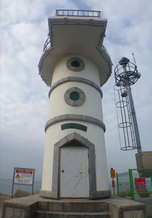
Date unknown. Active; focal plane 21 m (69 ft); green flash every 5 s. 7.5 m (23 ft) round cylindrical concrete tower painted white with gray trim. Choi Jin-yeol's photo is at right, Sunghoon Kim has a photo, Choi Jin-yeol has a photo, Lee Dae-beom has a closeup street view, and Google has a satellite view and a distant street view. Located on the breakwater on the north side of the entrance to Bangpo. Accessible by walking the pier. Site open, tower closed. KR-3287.20; Admiralty M4184.485.
Anmado
Date unknown. Active; focal plane 15 m (49 ft); red flash every 4 s. 22 m (72 ft) round concrete tower, painted red. Lothar Muenker has a photo, a very distant street view from the nearby beach is available, and Google has a satellite view. Located on a shoal about 2.5 km (1.5 mi) south of the entrance to the channel between Anmyeondo and the mainland. Accessible only by boat. Site open, tower closed. KR-3287.11; Admiralty M4184.49.
Sinon Hang (Gakssiseo, Amma Do)
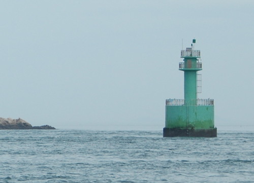
Date unknown. Active; focal plane 13 m (43 ft); green flash every 6 s. 14 m (46 ft) round cylindrical concrete tower mounted on a round concrete pier. Entire lighthouse is green. No photo available but Google has an indistinct satellite view and a very distant street view from shore. Located on a reef off the entrance to the channel between Anmyeondo and the mainland. Accessible only by boat. Site open, tower closed. KR-3287; Admiralty M4185; NGA 17848.
Hwangdo
About 2020. Active; focal plane 11 m (36 ft); green flash every 14 s. 14 m (46 ft) round green concrete tower. No closeup photo available but Google has a satellite view. A very distant view is available (light is upper right of center). Located at the south end of a shoal in Cheonsu Bay, off the northeast side of Anmyeondo. Accessible only by boat. Site open, tower closed. KR-3287.3; Admiralty M4184.414.

Bangpo Light, Anmyeon, February 2018
Google Maps photo by Choi Jin-yeol

Nam Township Lighthouses
Ulmido
Date unknown. Active; focal plane 71 m (233 ft); white flash every 6 s. 12 m (39 ft) round white concrete tower. No photo available but Google has a satellite view. Located on a small island about 10 km (6 mi) west of the entrance to Taean harbor. Accessible only by boat. Site open, tower closed. KR-3287.6; Admiralty M4184.35.
Geoado
Date unknown. Active; focal plane about 8 m (26 ft); white flash every 6 s. Approx. 8 m (26 ft) round concrete tower, colored white with a blue hrizontal band. No photo available but Google has a fuzzy satellite view. Located in the sound between the island of Geoado and Taean. Accessible only by boat. Site open, tower closed. KR-3287.1. Not listed by the Admiralty but charted by Navionics.
* Mageompo (Taean Bando)
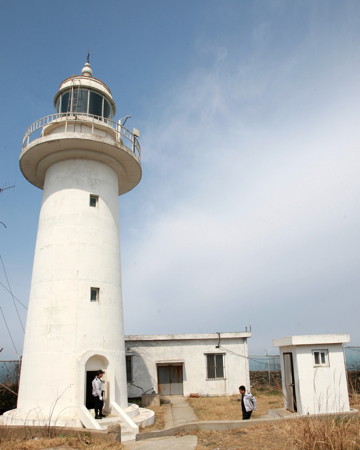
2000. Active; focal plane 17 m (56 ft); white flash every 6 s. 17 m (56 ft) round white concrete tower with gallery. Sanghyun Park's photo is at right, Kim Ki-Taek has a photo, and Google has a satellite view. Located a few feet off a rocky point on the west side of Mageompo. Site open, tower closed. Admiralty M4184.5; NGA 17839.8.
Deogam
Date unknown. Active; focal plane 13 m (43 ft); two white flashes every 10 s. 8 m (26 ft) round cylindrical concrete tower, painted black with a red horizontal band, mounted on a round concrete pier. A 2005 photo is available, there's another photo (second photo on the page) and Google has a satellite view and a distant street view. Located on a reef off the small harbor of Mongsanpo in western Taean. Accessible only by boat, but easy to see from shore. Site open, tower closed. KR-3290.6; Admiralty M4184.25.
Mongsanpo East Breakwater
Date unknown. Active; focal plane 16 m (52 ft); red flash every 6 s. 9 m (30 ft) round cylindrical steel tower painted red with narrow white horizontal bands. A 2021 street view is available, Cho Seong-chun has a view across the harbor, Brian Davidson has a distant street view and Google has a satellite view. Located on a detached breakwater at the entrance to Mongsanpo. Accessible only by boat but visible from shore. Site open, tower closed. KR-3290.9; Admiralty M4184.2.

Mageompo Light, Taean, October 2022
Google Maps photo by Sanghyun Park

Geunheung Township: Geunheung Peninsula and Sinjindo Lighthouses
Chaeseokpo
Date unknown. Active; focal plane 13 m (43 ft); red flash every 4 s. 16 m (52 ft) round cylindrical concrete tower, painted red, mounted on a round concrete pier. A 2021 photo is available and Google has a satellite view. Located on a reef off Chaeseokpo harbor. Accessible only by boat, but easy to see from shore. Site open, tower closed. KR-3290.3; Admiralty M4184.1.
Geunheung
Date unknown. Active; focal plane 14 m (46 ft); six quick white flashes followed by one long white flash every 15 s. 20 m (66 ft) round cylindrical concrete tower mounted on a round concrete pier. Upper half of the lighthouse painted yellow, lower half black. No photo available but Google has a satellite view. Located on a reef about 5 km (3 mi) southwest of the Chaeseokpo light. Accessible only by boat, but easy to see from shore. Site open, tower closed. KR-3291.2; Admiralty M4184.05.
Haengyeo
2003. Active; focal plane 15 m (49 ft); two white flashes every 10 s. 17 m (56 ft) tower painted black with one red horizontal band. No photo available and the light is not shown in Bing's satellite view. Located on a rock about 5 km (3 mi) southeast of Anheung. Accessible only by boat. Site open, tower closed. KR-3290; Admiralty M4154.2; NGA 17841.
Anheung Hang South
Date unknown. Active; focal plane 18 m (59 ft); two white flashes every 10 s.. 18 m (59 ft) tower painted black with one red horizontal band. No photo available but Google has an indistinct satellite view. Located on a reef about 1.25 km (3/4 mi) south of Anheung. Accessible only by boat. Site open, tower closed. Admiralty M4154.205.
* Anheung Hang (Inner Port) East Breakwater (2)
Date unknown. Active; focal plane 13 m (43 ft); two red flashes every 6 s. 8 m (26 ft) round cylindrical concrete tower, painted red. Seo Young-sam has a 2019 photo (also seen at right), a 2020 photo is available, and Google has a satellite view. This light replaced a round hourglass-shaped concrete tower, painted red. A photo (halfway down the page, just after the green west breakwater light) is available and there are photos of both original breakwater lights. Anheung is a small port about 20 km (13 mi) southwest of Taean; it is located on Sinjindo, a small island just off the end of the Geunheung Peninsula. The inner port is the strait separating the island from the mainland; it is no longer in much use. The harbor entrance is spanned by a remarkable two-span through-arch pedestrian bridge. Located on a short breakwater on the east side of the south entrance to the channel separating Anheung from the mainland. Accessible by walking the pier. Site open, tower closed. KR-3293; Admiralty M4154.5; NGA 17852.
#Anheung Hang (Inner Port) West Breakwater
Date unknown. Deactivated in 2018 and then removed. 13 m (43 ft) round cylindrical concrete tower, painted green. A photo (halfway down the page) is available and there are photos of both original breakwater lights, but Google's satellite view confirms the removal of the light. Formerly located on a short jetty on the west side of the south entrance to the channel separating Anheung from the mainland. ex-KR-3294; ex-Admiralty M4154.6.

Anheung Hang East Breakwater Light, Anheung, August 2019
Google Maps photo by Seo Young-sam
* Sinjindo (Anhung Shin) South Breakwater (2)
Date unknown. Active; focal plane 16 m (52 ft); red flash every 6 s. 10 m (33 ft) round red concrete tower with lantern and gallery. This is the lighthouse on the left in a 2015 photo of both breakwater lights and Google has a satellite view. The lighthouse replaced a round cylindrical tower. Located at the end of the south breakwater of Anheung Outer Port. Accessible by walking the pier. Site open, tower closed. KR-3296; Admiralty M4154.4; NGA 17851.
Sinjindo (Anheung Sin Hang) Detached Breakwater South Head
Date unknown. Active; focal plane 16 m (52 ft); green flash every 6 s. 9 m (30 ft) white concrete tower with lantern and gallery. Lee Se-Jin has a photo and Google has a satellite view. Located at the south end of a detached breakwater sheltering the Sinjindo Outer Port. Accessible only by boat. Site open, tower closed. KR-3295.7; Admiralty M4154.3 (?).
* #Sinjindo (Anhung Shin) North Breakwater (1)
Date unknown. Replaced in 2019. This was an 11 m (36 ft) round white concrete tower with gallery. This is the lighthouse on the right in a 2015 photo of both breakwater lights but Google's satellite view shows it has been replaced by a yellow post light. Balbalta Asura has a 2022 photo of the current light. Located at the end of the north breakwater of Anheung Outer Port. Accessible by walking the pier. Site open, tower closed. ex-Admiralty M4154.3; NGA 17850. Active light: KR-3295; Admiralty M4154.38.
Hwagiseo
2003. Active; focal plane 11 m (36 ft); red flash every 4 s. 22 m (72 ft) tower, painted red. This light is seen in the left distance in Lee Se-Jin's photo of the detached breakwater south end light and Google has a satellite view. Located on a shoal about 1.5 km (1 mi) southwest of Anheung harbor. Accessible only by boat. Site open, tower closed. KR-3291.1; Admiralty M4154.27.
Geomeunyeo (Mokkaedo)
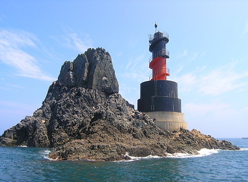
2005. Active; focal plane 17 m (56 ft); two white flashes every 5 s. 16 m (52 ft) tower, painted black with one red horizontal band. A photo is at right and Google has a satellite view. Located on a rock about 5 km (3 mi) southwest of Sinjindo-ri. Accessible only by boat. Site open, tower closed. KR-3290.2; Admiralty M4154.25; NGA 17840.8.

Geunheung Township: West Sea Islands (Gauido Village) Lighthouses
Anheung Hang Approach
Date unknown. Active; focal plane 14 m (46 ft); two white flashes every 5 s. 21 m (69 ft) tower, painted black with one red horizontal band. No photo available but Bing has an indistinct satellite view. Located on a shoal about 5 km (3 mi) west southwest of Anheung and 3 km (2 mi) south of Gauido. Accessible only by boat. Site open, tower closed. KR-3290.7; Admiralty M4154.26.
Gauido (Kauido)
Date unknown. Active; focal plane 12 m (39 ft); quick-flashing white light. 21 m (69 ft) round cylindrical concrete tower, mounted on a round concrete pier. Upper half of the tower painted black, lower half yellow. A distant view is available and Google has a satellite view. Located on a rocky reef off the north side of the island of Gauido, about 6 km (3.5 mi) west of Anheung. Accessible only by boat. Site open, tower closed. KR-3290.8; Admiralty M4154.22; NGA 17849.

Geomeunyeo Light, Geunheung
Daesan Regional Oceans and Fisheries Administration photo
** Ongdo (Ong Do) (2)
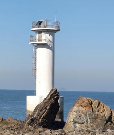
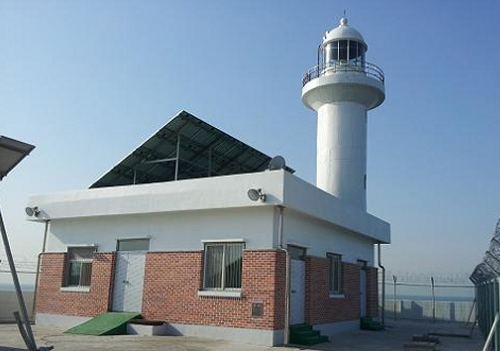
2009 (station established 1907). Active; focal plane 75 m (246 ft); white flash every 15 s. 14 m (46 ft) round cylindrical concrete tower with lantern and gallery, rising from a 1-1/2 story museum building. Lighthouse painted white. This was South Korea's last staffed light station. Lee Young-min's 2019 closeup photo is at the top of this page, Daesan Cceans and Fisheries has a good 2013 photo, Song Kwang Yeol has a 2017 photo, Kim In Ki has a closeup, and Google has a satellite view of the station. The shipping channels leading to Incheon begin between the Ongdo and Gungsido (next entry) lighthouses. Located atop a small island about 12 km (7.5 mi) west southwest of Anheung. Accessible only by boat; guided tours are reported to be available. Site open to tours, tower status unknown. . ARLHS SKR-020; KR-3289; Admiralty M4154; NGA 17840.
Gungsido (Geungshido, Kungshido)
2010. Active; focal plane 96 m (315 ft); white flash every 5 s. 11 m (36 ft) round white concrete tower. No photo available and Google has only a fuzzy satellite view of the island. Located on an island about halfway between Anheung and the Gyeongnyeolbido lighthouse. Accessible only by boat. Site status unknown. KR-3291; Admiralty M4153.7.
Gyeongnyeolbido (Kyongnyolbi, North Clifford Island) (2)
2011 (station established 1909). Active; focal plane 112 m (367 ft); white flash every 10 s. 14 m (46 ft) round white concrete tower with lantern and gallery. A photo is at right, a 2021 street view is available, and Sung Elvyn has a very distant aerial view, but Google has only a fuzzy satellite view of the island. The original lighthouse was a 14 m (46 ft) hexagonal white concrete tower. Located atop an isolated island in the Yellow Sea about 75 km (45 mi) west of Anheung. Accessible only by boat, and it appears that access to this strategically located island is restricted. Site status unknown. ARLHS SKR-014; KR-3288; Admiralty M4184; NGA 17844.
Heukdo
Date unknown. Active; focal plane 117 m (384 ft); two white flashes every 6 s. 20 m (66 ft) octagonal white skeletal tower with double gallery. A blogger has a closeup following several distant views (1/3 the way down the page), another distant view is available and Google has an indistinct satellite view. This light and the next one, Gadaeam, are crucial landmarks for ships approaching Incheon; inbound ships pass east of these lights and outbound ships pass to the west. Located on a steep island about 13 km (8 mi) northwest of Gauido. Accessible only by boat. Site status unknown. KR-3296.5; Admiralty M4153.3; NGA 17853.5.
Gadaeam (Kadae Am)
Date unknown (2001?). Active; focal plane 15 m (49 ft); three quick white flashes every 10 s. 17 m (56 ft) round concrete tower, painted black with one yellow horizontal band. No photo available and the tower is not seen in Google's satellite view. Located on a shoal about 16 km (10 mi) northwest of Anheung. Accessible only by boat. Site open, tower closed. KR-3298; Admiralty M4153; NGA 17854.
Gyeongnyeolbido Light
Gyeongnyeolbido Light, April 2011
ex-Daum.net Creative Commons photo

Sowon Township Lighthouses
Tonggye Hang
2003. Active; focal plane 13 m (43 ft); two white flashes every 10 s. 17 m (56 ft) tower, painted black with one red horizontal band. Several distant views (starting halfway down the page) are available, the light is at the center of Shin Woo-jae's distant view, and Google has a satellite view. Located on a reef in Geunso Bay off the harbor of Tonggye, a small port on the south side of the Pado Peninsula occupied by Pado Village. Accessible only by boat, but easily seen from shore. Site open, tower closed. KR-3298.2; Admiralty M4154.66.
Hwachangyeo
2007. Active; focal plane 14 m (46 ft); green flash every 4 s. 22 m (72 ft) round cylindrical concrete tower, mounted on a round concrete pier. Lighthouse and pier painted green. A photo is at right and Google has a satellite view. Located off the tip of the Pado peninsula, about 4 km (2.5 mi) northwest of Anheung. Accessible only by boat. Site open, tower closed. KR-3296.3; Admiralty M4154.21.
* Yeoeundol Hang
2009. Active; focal plane 14 m (46 ft); green flash every 4 s. 10 m (33 ft) octagonal cylindrical white concrete tower. A 2022 photo is available as are several photos (starting a little past halfway on the page) and Google has a street view and a satellite view. Located on the north breakwater of Yeoeundol, a small harbor on the north side of the Pado peninsula. Accessible by walking the pier. Site open, tower closed. KR-3298.1; Admiralty M4154.69; NGA 17853.
Mohang Hang
Date unknown. Active; focal plane 42 m (138 ft); white flash every 6 s. 12 m (39 ft) round cylindrical white concrete tower. Hogeun Park has a distant aerial view and Google has an indistinct satellite view. Located on a headland a short distance west of the harbor of Mohang. Site status unknown. KR-3298.4; Admiralty M4154.8.
Hwachangyeo Light
Hwachangyeo Light, Sowon,August 2011
ex-Panoramio photo copyright plumgarden; used by permission
* Mohang Hang South Breakwater
Date unknown. Active; focal plane 17 m (56 ft); two red flashes every 6 s. 15 m (49 ft) round cylindrical concrete tower, painted red. A photo and additional photos are available, Ryu Won-hyun has a view across the harbor, Hogeun Park has an aerial view, and Google has a satellite view. Located at the end of the south breakwater at Mohang. Accessible by walking the pier. Site open, tower closed. KR-3298.9; Admiralty M4154.92.
* Mohang Hang North Breakwater
Date unknown. Active; focal plane 16 m (52 ft); two green flashes every 6 s. 11 m (36 ft) round cylindrical concrete tower, painted white. Several photos of both breakwater lights are available, Hogeun Park has an indistinct aerial view,and Google has a satellite view. Located at the end of the south breakwater at Mohang. Accessible by walking the pier. Site open, tower closed. KR-3298.8; Admiralty M4154.9.
* Mallipo (Manlipo, Manripo) (2)
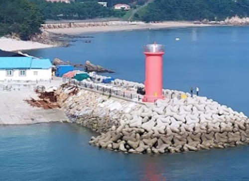
2018 (?). Active; focal plane 13 m (43 ft); red flash every 6 s. 8 m (26 ft) round cylindrical concrete tower with lantern and gallery. Entire lighthouse is red. Daehwan Kim's 2021 photo is at right, Kim Jinyeol has a 2020 sunset photo and Google has a satellite view. Located at the end of a groin that helps maintain a broad beach a short distance north of Mohang Hang. Accessible by walking the groin. Site open, tower closed. KR-3297; Admiralty M4154.7; NGA 17860.
Dakseom
Date unknown. Active; focal plane 16 m (52 ft); two white flashes every 6 s. 14 m (46 ft) round cylindrical white concrete tower with double gallery. A photo (halfway down the page) and a very distant view are available and Google has a satellite view. Located at the seaward end of an island just offshore about 4 km (2.5 mi) north of Mohang. Accessible only by boat. Site open, tower closed. Admiralty M4154.75.
Uihangri
2017 (?). Active; focal plane 15 m (49 ft); nine qucik white flashes every 15 s. 19 m (62 ft) round cylindrical concrete tower painted yellow with one black horizontal band. Younggyu Jang has a distant view from shore and Google has a satellite view. Located on a reef about 1 km (0.6 mi) north of the small harbor of Cheollipo. Accessible only by boat. Site open, tower closed. KR-3299.1; Admiralty M4154.78.

Mallipo Light, Sowon,October 2021
Google Maps photo by Daehwan Kim

Wonbung Township Lighthouses
Sindu Hang (Uihangri)
Date unknown. Active; focal plane 11 m (36 ft); green flash every 5 s. 16 m (52 ft) round green concrete tower. A distant view is available and Google has a satellite view. Located on a reef in the entrance to Sindu harbor. Accessible only by boat. Site open, tower closed. KR-3302; Admiralty M4156.33; NGA 17862.
Sindotaseo
2005. Active; focal plane 16 m (52 ft); green flash every 6 s. 15 m (49 ft) round green concrete tower. No photo available but Google has a satellite view. Located on a reef about 8 km (5 mi) north of Taean harbor. This light and the Gudo Light (see below) are on the west side of the approach channel to Incheon. Accessible only by boat. Site open, tower closed. KR-3321; Admiralty M4156.35; NGA 17863.
Jeonggokdu (Chongkoktu)
Date unknown. Active; focal plane 20 m (66 ft); white flash every 6 s. 7 m (23 ft) round white concrete tower. No photo available but Google has an indistinct satellite view. Located on a promontory about 6.5 km (4 mi) southwest of the Taean harbor entrance. Site status unknown. KR-3318; Admiralty M4156.3; NGA 17868.
Gwido (Gudo, Kudo)
Date unknown. Active; focal plane 16 m (52 ft); green flash every 5 s. 14 m (46 ft) round green concrete tower. No photo available but Bing has a satellite view. Located on a reef about 8 km (5 mi) north of Taean harbor. Accessible only by boat. Site open, tower closed. KR-3322; Admiralty M4156.38; NGA 17863.5.
Ando (An Do) (2)
2011 (station established 1911). Active; focal plane 43 m (141 ft); white flash every 10 s. 18 m (59 ft) round cylindrical concrete tower with lantern and gallery, painted white. Keeper's houses and other light station buildings. A photo is at right and Bing has a satellite view. The lighthouse guides vessels approaching the port of Daesan. It was replaced in a major project in 2011, marking the 100th anniversary of the station. Located atop a small island about 12 km (7.5 mi) west of Tokkot. Accessible only by boat. Site status unknown. ARLHS SKR-001; Admiralty M4156; NGA 17864.
* Hagampo (Hakampo) Hang
Date unknown. Active; focal plane 14 m (46 ft); red flash every 6 s. 8 m (26 ft) round cylindrical red concrete tower. Koo Yoon Kyung has a photo, Lee Ji-yong has a 2021 photo, and Google has a street view and a satellite view. Located on the breakwater at Hagampo near the northern tip of Taean. Accessible by walking the pier. Site open, tower closed. KR-3312.1; Admiralty M4156.385.

Ando Light, Wonbung, 2012
Daesan Regional Oceans and Fisheries Administration photo
Suinyeo
Date unknown. Active; focal plane 16 m (52 ft); red flash every 5 s. 16 m (52 ft) round red concrete tower. No photo available but Google has a satellite view. Located about 600 m (3/8 mi) off the northern tip of Taean. Accessible only by boat. Site open, tower closed. KR-3309; Admiralty M4156.48; NGA 17893.5.

Information available on lost lighthouses:

Notable faux lighthouses:

Adjoining pages: North: Dangjin and Pyeongtaek | South: Boryeong Area

Return to the Lighthouse Directory index | Ratings key

Posted February 4, 2008. Checked and revised June 23, 2024. Lighthouses: 47. Site copyright 2024 Russ Rowlett and the University of North Carolina at Chapel Hill.