Lighthouses of South Korea: Heuksan Islands

For most of its history Korea was an independent kingdom or at least an autonomous kingdom under Chinese influence. This came to an end in 1910 when Japan annexed all of Korea. At the end of World War II in 1945 the 38° parallel was established as the dividing line between U.S. and Soviet zones of occupation, and in 1948 separate civil administrations were established in the two halves of the country. The Korean War (1950-53) ended in a draw, with the armistice line falling close to the prewar 38° line. The Republic of Korea (ROK), commonly called South Korea, occupies the Korean peninsula south of the armistice line.

South Korea is divided into nine provinces and eight province-level cities; the provinces are subdivided into counties and cities. This page covers lighthouses of the Heuksan Islands, a loose scattering of islands well off the southwestern coast of South Korea. The islands comprise the Heuksan Township (Heuksan-myeon) of Sinan County, a part of South Jeolla Province. Several of the islands are inhabited but the total population (as counted in January 2014) is only 2300.

In 2000 South Korea adopted a Revised Romanization System to replace systems formerly used in the West. In the Revised System, the word for a lighthouse is deungdae (등대); dan (formerly tan) is a cape, seom (som) or do (to) is an island, am or amseog is a rock, man is a bay, and hang is a harbor. Some place names may be more familiar to Westerners in the spellings of older systems.

Navigational aids in the ROK are regulated by the Ministry of Oceans and Fisheries (MOF). Lighthouses in Sinan are maintained by the Mokpo Regional Maritime Affairs and Port Authority.

ARLHS numbers are from the ARLHS World List of Lights. KR numbers, where available, are from the Korean light list. Admiralty numbers are from volume M of the Admiralty List of Lights & Fog Signals. U.S. NGA List numbers are from Publication 112.

General Sources
Port of Mokpo - Lighthouses
Photos and information in English for the major lighthouses of the area.
Lighthouses in South Korea
Photos available from Wikimedia.
Online List of Lights - Korea - Yellow Sea
Photos by various photographers posted by Alexander Trabas.
Navionics Charts
Navigation chart for the islands.


Hongdo Light, Hongdo, April 2019
Google Maps photo by J.G. Jeon
Gageodo Lighthouses
Gageodo is Korea's southwesternmost island, making these Korea's most remote lighthouses. The island is about 6 km (3.5 mi) long and has a population of about 500; it is accessible by ferry.

Gageodo (Soheuksando, Sohuksan Do)
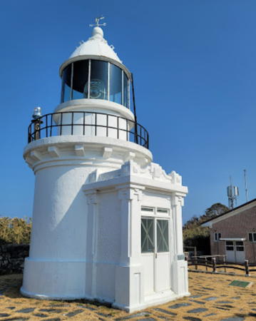
1907. Active; focal plane 84 m (276 ft); white flash every 15 s. 11 m (36 ft) round cylindrical concrete tower with lantern and gallery. Lighthouse painted white. Fog horn (one blast every 60 s). Daechang Cho's 2022 photo is at right, Jang-oh Lee has a 2021 photo, Yong Sun Kim also has a 2021 photo, Cho Dae-chang has a 2022 closeup, and Google has a satellite view. Located at the northwestern point of the island of Gageodo, about 100 km (60 mi) west southwest of Jindo. Accessible only by boat. Site open, tower status unknown. . Admiralty M4227; NGA 17708.
Mulseongmal (Mulsogmal)
Date unknown. Active; focal plane 156 m (512 ft); white flash every 10 s. 6.5 m (21 ft) octagonal white concrete tower. No photo available but Google has a distant satellite view. Located on heights at the southeastern end of Gageodo. Accessible only by boat. Site status unknown. KR-3031; Admiralty M4227.4; NGA 17710.
Gageodo-ri (Kagodo-ri) (2)
Date unknown. Active; focal plane 15 m (49 ft); green flash every 5 s. 12 m (39 ft) tapered triangular white concrete tower. Kyu-Jeong Chai has a 2021 photo, Hyun Kim has a view from a passing ferry, YoungGyu Cho has a view from the sea, and Google has a satellite view. Located on a recent extension of the breakwater of Gageodo village, at the south end of the island. Site status unknown. KR-3030.9; Admiralty M4227.1.
Gageocho Ocean Research Station
2018. Active; focal plane 33 m (108 ft); two short white flashes and one long white flash every 8 s. The light is on a 3 m (10 ft) post atop the 30 m (98 ft) research station supported by robust piles. The tower is not shown in Google's satellite view. Located on a shoal 47 km (29 mi) southwest of Gageodo. Accessible only by boat. Site open, tower closed. KR-3032.1; Admiralty M4227.8.

Manjaedo Lighthouse
Manjaedo (Maury Island)
Date unknown. Active; focal plane 195 m (640 ft); white flash every 5 s. 5.5 m (18 ft) round white concrete tower. Seongtaek Lim has a 2022 closeup photo, a second photo (halfway down the page) is available, and Google has an indistinct satellite view. Located on an isolated high island about 50 km (30 mi) northeast of Gageodo. Accessible only by boat and a difficult hike up the mountain. Site open, tower closed. KR-3026; Admiralty M4228; NGA 17704.


Gageodo (Soheuksando) Light, Gageodo, February 2022
Google Maps photo by Daechang Cho


Hataedo Lighthouses
Hataedo
Date unknown. Active; focal plane 32 m (105 ft); white flash every 6 s. 6 m (20 ft) round white concrete tower. A photo (4/5 the way down the page) is available but Google has a satellite view. Located on an island about 60 km (38 mi) north northeast of Gageodo. Accessible only by boat. Site status unknown. KR-3034; Admiralty M4226; NGA 17700.
Darado
Date unknown. Active; focal plane 58 m (190 ft); white flash every 6 s. 9.5 m (31 ft) round white tower. No photo available but Google has a satellite view. Located on a small island off the east coast of Hataedo. Accessible only by boat. Site status unknown. KR-3034.1; Admiralty M4225.8.

Hongdo Area Lighthouses
* Hongdo
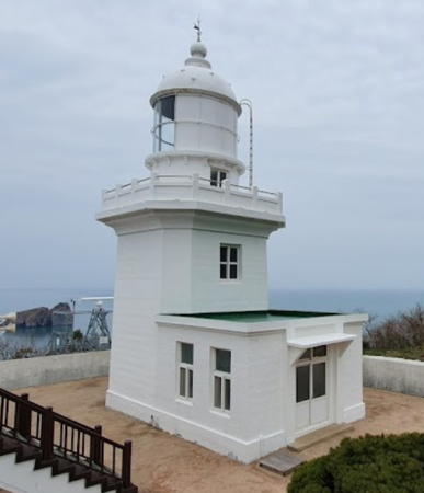
1931. Active; focal plane 89 m (292 ft); three white flashes every 20 s. 14 m (46 ft) two-stage square concrete tower with lantern and gallery. Lighthouse painted white, with a narrow green horizontal band. 1-story concrete keeper's house and other light station buildings. J.G. Jeon's 2019 photo is at the top of this page, a fine closeup and another photo are available, Korean National Parks posted a nice photo, and Google has a distant satellite view of the station. Hongdo is a small island about 115 km (72 mi) west of Mokpo. Ferry transportation to the island is available. Located at the northern tip of the island. Site open, tower closed. Site manager: Dadohaehaesang National Park. . ARLHS SKR-041; KR-3036; Admiralty M4222; NGA 17696.
Juk (Chuk) Hang Approach
Date unknown. Active; focal plane 30 m (98 ft); two white flashes every 6 s. 8 m (26 ft) round cylindrical white concrete tower. The Port of Mokpo has a photo and Google has a distant satellite view. Located on one of the outermost of a large collection of picturesque rocky pinnacles obstructing the approach to Chuk harbor, the harbor of Hongdo. Accessible only by boat. Site status unknown. KR-3035; Admiralty M4222.2; NGA 17697.
* Juk (Chuk) Hang Breakwater (2)
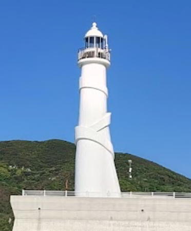
2018(?). Active; focal plane 27 m (89 ft); two green flashes every 6 s. 20 m (66 ft) round white concrete tower with lantern and gallery. Bong Shim's 2021 photo is at right, Kim Hee-il has a 2022 aerial view, and Sugi Da has an October 2018 street view, but Google's current satellite view shows the older and shorter light in use before the breakwater was extended; a 2013 street view of that light is available. Located on a recent extension of the main (south) breakwater of Chuk Hang. Accessible by walking the pier. Site open, tower closed. KR-3037.2; Admiralty M4222.3.

Juk Hang Breakwater, Light, Hongdo, May 2021
Google Maps photo by Bong shim
* Juk (Chuk) Hang Breakwater Spur
2022(?). Active; focal plane about 15 m (49 ft); yellow light, pattern unknown. Approx. 10 m (33 ft) round oncrte tower with lntern and gallery, painted yellow. Kim Hee-il has a 2022 aerial view but the light is not shown in Google's satellite view. Located on a short spur off the main breakwater. Probably accessible by walking the pier. Site open, tower closed. Not yet listed by the Admiralty.

Daeheuksando (Heuksan Island) Area Lighthouses
Hojangdo (2)
Date unknown. Active; focal plane 78 m (256 ft); white flash every 10 s. 8.5 m (28 ft) square white concrete tower. No photo available; there is a very distant 2009 aerial view and Google has a distant satellite view. Light lists previously described a round tower. Located on a small island off the north coast of Daeheuksando. Accessible only by boat. Site status unknown. KR-3040; Admiralty M4222.5; NGA 17678.
Hajukdo (Hajuk-to)
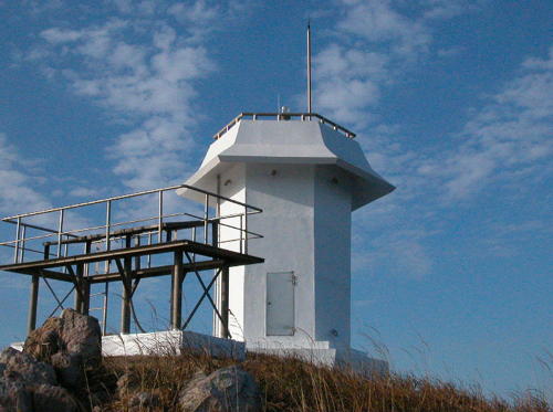
Date unknown. Active; focal plane 100 m (328 ft); white flash every 5 s. 6 m (20 ft) hexagonal white concrete tower. The Port of Mokpo's photo is at right, Naver has a photo (eighth photo on the page) and Google has a satellite view. This light marks the northern tip of the Heuksan islands. The original light was on a round tower. Located on an island about 8 km (5 mi) north of Daeheuksando. Accessible only by boat. Site status unknown. KR-3042; Admiralty M4225; NGA 17676.
Seungseo
Date unknown. Active; focal plane 17 m (56 ft); two white flashes every 5 s. 21 m (69 ft) round concrete tower rising from a square platform supported by piles. Tower painted black with one red horizontal band. No photo available but Google has a satellite view. Located on a shoal off the south coast of Damuldo, an island about 5 km (3 mi) north of Daeheuksando harbor. Accessible only by boat. Site status unknown. KR-3040.2; Admiralty M4225.3.
Heukseo
Date unknown. Active; focal plane about 18 m (59 ft); white light, characteristic unknown. Approx. 10 m (33 ft) round cylindrical white tower. Hee Chan Oh has a view from the sea, several additional photos (near the bottom of the page) are available, and Google has a satellite view. Located on a small island just off the entrance to Daeheuksando harbor. Accessible only by boat. Site status unknown. KR-3041.1; Admiralty M4223.41.

Hajukdo Light, Damuldo
Port of Mokpo photo posted on Librewiki.net
* Daeheuksando (Taeheuksando, Taehuksando) North Breakwater (2)
Date unknown. Active; focal plane 13 m (43 ft); two red flashes every 6 s. 8.5 m (28 ft) round cylindrical concrete tower, painted red. Kim Beom-seok has a distant street view from the south breakwater and Google has a satellite view. The Admiralty and NGA list a skeletal tower at this location. Daeheuksando is an island about 16 km (10 mi) long and about 130 km (80 mi) east of Mokpo; it is the largest and most populous of the Heuksan islands. Located at the end of the north breakwater of Daeheuksando harbor, at the north end of the island. Accessible by walking the pier. Site open, tower closed. KR-3039; Admiralty M4223.4; NGA 17683.
* Daeheuksando (Taeheuksando, Taehuksando) South Breakwater
Date unknown. Active; focal plane 13 m (43 ft); two green flashes every 6 s. 8 m (26 ft) octagonal concrete tower. Entire lighthouse is white. A photo is available, Kim Beom-seok has a closeup 2021 street view, and Google has an indistinct satellite view. Located at the end of the south breakwater of Daeheuksando harbor. Accessible by walking the pier. Site open, tower closed. KR-3038; Admiralty M4223.3; NGA 17682.
* Daeheuksando (Taeheuksando, Taehuksando) Inner Breakwater (2)
2013 (station establishment date unknown). Active; focal plane about 15 m (49 ft); green flash every 4 s. 14 m (46 ft) round cylindrical concrete tower with lantern and gallery, built to resemble a ship. Entire lighthouse is white. An observation platform surrounds the base of the lighthouse. A photo is at right, a 2018 closeup is available, and Google has a satellite view. Located at the end of the south breakwater of Daeheuksando harbor. Accessible by walking the pier. Site and observation deck open, tower closed. KR-3037; Admiralty M4223; NGA 17684.
Gado
Date unknown. Active; focal plane 63 m (207 ft); white flash every 6 s. 6 m (20 ft) round white concrete tower. No photo available but Google has a satellite view. Located on a small island about 2.5 km (1.5 mi) northeast of Daeheuksando harbor. Accessible only by boat. Site status unknown. Admiralty M4224; NGA 17680.

Inner Breakwater Light, Daeheuksando, December 2013
Yeonhap News photo
Jongdariam
Date unknown. Active; focal plane 12 m (39 ft); quick-flashing white light. 11 m (36 ft) round steel tower, upper half painted black and lower half yellow. No photo available but Google has a distant satellite view. Located on a rock in a narrow passage north of Gado. Accessible only by boat. Site status unknown. KR-3040.1; Admiralty M4222.1; NGA 17679.
Daehangdo (Yeongsando, Yongsando, Taehand-do)
Date unknown. Active; focal plane 51 m (167 ft); white flash every 4 s. 11 m (36 ft) round white concrete tower. No photo available but Google has a distant satellite view. Located atop a steep-sided island just off the northeast corner of Yeongsando, an island southeast of Daeheuksando. Accessible only by boat. Site status unknown. KR-3033; Admiralty M4223.5; NGA 17688.
Gallarimal (Taehuksan Do)
Date unknown. Active; focal plane 46 m (151 ft); white flash every 6 s. Listed as a 6 m (20 ft) hexagonal white metal tower. No photo available but Google has an indistinct satellite view. Located on a sharp promontory on the southwestern coast of Daeheuksando. Site status unknown. Admiralty M4223.8; NGA 17694.
Songammel (Daejangdo, Taejangdo) (2?)
Date unknown. Active; focal plane 23 m (75 ft); white flash every 4 s. 8 m (26 ft) white concrete tower. No photo available but Google has a satellite view. This light and the next one are described as "metal pipes" in the light lists, but the satellite views are consistent with concrete towers. Located at the southern tip of Daejangdo, an island off the west coast of Daeheuksando. Accessible only by boat. Site status unknown. KR-3037.1; Admiralty M4223.9; NGA 17695.
Jangsudo (2?)
Date unknown. Active; focal plane about 15 m (49 ft); white light, pattern unknown. Approx. 12 m (39 ft) white concrete tower. No photo available but Google has a satellite view. Located on a small island off the northwest coast of Daeheuksando. Accessible only by boat. Site status unknown. KR-3039.1; Admiralty M4223.85.

Maebuldo Lighthouse
Maebuldo (Kyomaek To)
Date unknown. Active; focal plane 128 m (420 ft); white flash every 10 s. 6 m (20 ft) round white fiberglass tower. No photo available, but Bing has an indistinct satellite view. Located on an isolated high island about 20 km (13 mi) southeast of Daeheuksando. Accessible only by boat. Site status unknown. KR-3109; Admiralty M4225.5; NGA 17692.

Information available on lost lighthouses:

Notable faux lighthouses:

Adjoining pages: East: Sinan

Return to the Lighthouse Directory index | Ratings key

Posted January 9, 2008. Checked and revised May 1, 2024. Lighthouses: 25. Site copyright 2024 Russ Rowlett and the University of North Carolina at Chapel Hill.