Lighthouses of India: Lakshadweep (Laccadive, Amindivi, and Minicoy Islands)

The Republic of India (Bhārat in Hindi) is the seventh largest country and second most populous country in the world. It occupies a subcontinent of Asia that projects southward into the North Indian Ocean, separating the Bay of Bengal on the east from the Arabian Sea on the west. Before 1947 it was a patchwork of regions governed as British colonies and semi-independent princely states under British supervision. In 1947 this British Raj was partitioned into the independent states of India and Pakistan. Several French and Portuguese colonies embedded in the territory of India were absorbed in 1950 and 1961, respectively.

India is a federal union comprising 28 states and 8 union territories. Lakshadweep is a union territory including twelve atolls, three reefs and five submerged banks (representing submerged atolls) in the Arabian Sea, roughly 250 km (150 mi) off the southwestern coast of the country. About 65,000 people of mixed Indian and Arab descent live on 17 inhabited islands in the territory. The Amindivi Islands are in the northern part of the territory, the Laccadive Islands are in the center, and Minicoy Island is in the south. The entire territory is sometimes called the Laccadive Islands.

Britain took control of the islands during the nineteenth century as part of the British Raj and the islands remained under India's control after independence. The only historic British lighthouse in the islands is at Minicoy but since 1967 India has constructed lighthouses or light towers on all the major atolls.

Tourism is encouraged but due to limited accommodations tourists need a permit to visit the islands. There is air service to Agatti island from Cochin as well as ferry service from Cochin to all the inhabited islands.

In Malayalam, the official language of Lakshadweep, the word for a lighthouse is viḷakkumāṭaṁ (വിളക്കുമാടം). Dvīp is an island, aṟṟēāḷ is an atoll, and tuṟamukhaṁ is a harbor.

Lighthouses and aids to navigation in India are administered by the Directorate General of Lighthouses and Lightships (DGLL), an agency of the Ministry of Shipping. Lighthouses in Lakshadweep are maintained by the Kochi Directorate of DGLL.

ARLHS numbers are from the ARLHS World List of Lights. Admiralty numbers are from volume F of the Admiralty List of Lights & Fog Signals. U.S. NGA List numbers are from Publication 112.

General Sources
Aids to Navigation - Kochi Region
Lighthouse information from DGLL, including photos for most of the lighthouses.
Lighthouses in Lakshadweep
Photos by various photographers available from Wikimedia.
Online List of Lights - India
Photos by various photographers posted by Alexander Trabas.
Indian Lighthouses
Historic postcard views posted by Michel Forand.
Lakshadweep Map
This useful map is posted on Wikimedia.
Navionics Charts
Navigation chart for the islands.
Minicoy Light
Minicoy Light, Maliku, Christmas Day 2007
Flickr Creative Commons photo by MrsFife
Maliku (Minicoy Island) Lighthouses
Minicoy, located well to the south of the other islands of the territory, has a distinct population and language and is geographically part of the Maldives archipelago. In fact it has been claimed by Maldives, although it has been governed from India since the late 18th century and a treaty between India and Maldives recognizes it as Indian territory. The name Minicoy, applied by the British, is an error; the islanders call their home Maliku. There is a resort on the island with transportation and day tours available.
*** Minicoy (Minicoy South, Maliku)
1885. Active; focal plane 47 m (154 ft); white flash every 15 s. 48 m (157 ft) round brick tower with lantern and gallery. Lighthouse painted white; lantern roof is red. The lighthouse is staffed. A photo appears above, Shijo Jose has a 2017 photo, Vijay Kumar has a photo, another photo shows visitors on the gallery, Lighthouse Digest has a February 2001 feature on the lighthouse by I.C.R. Prasad, Forand has a historic postcard view, and Google has a satellite view. The island has great strategic importance because the sea route from Suez to Singapore passes through the Eight Degree Channel just south of Minicoy. To protect this lifeline of the Empire the British shipped bricks from England to build this great lighthouse in the tropics, designed by Sir James Douglass. Following India's independence the light station continued to be operated by the British lighthouse authority Trinity House until April 1956, when it was assigned to DGLL; the title to the property was finally transferred to India in September 1963. The 50th anniversary of Indian control was celebrated in 2006. Located on the southwestern shore of the island. Site open, tower open by arrangement with the keepers. ARLHS LAK-009; Admiralty F0758; NGA 27468.
* Minicoy (Maliku) North
2008. Active; focal plane 22 m (72 ft); two white flashes every 10 s. 22 m (72 ft) square masonry or concrete tower, painted with black and white horizontal bands. Google has a satellite view. This lighthouse was built in connection with construction of a new jetty and improved landing facilities on the northeast side of the island. Located close to the new jetty. Site open, tower closed. Admiralty F0758.1; NGA 27470.

Laccadive Islands Lighthouses
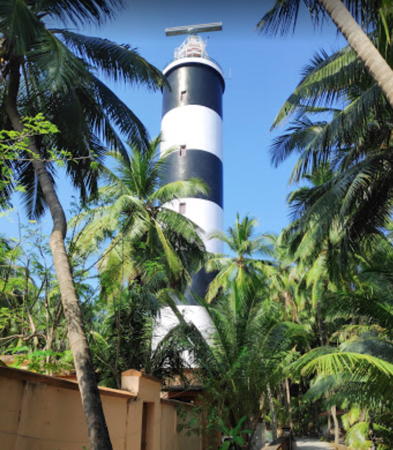
Kalpeni
1976. Active; focal plane 44 m (144 ft); three white flashes every 20 s. 40 m (131 ft) round cylindrical concrete block tower with lantern and gallery. Lighthouse painted with horizontal black and white bands. A 2019 closeup photo is at right, Nithin Uliyar has a closeup (3/4 the way down the page), a distant view from the sea is available, and Google has a satellite view of the tower. Kalpeni is at the southeastern end of the Laccadives; it is an inhabited island with several resorts. Transportation and day tours available. Site open, tower probably open by arrangement with the keepers. ARLHS LAK-004; Admiralty F0757; NGA 27612.

Kalpeni Light, Kalpeni, December 2019
Google Maps photo by DANE
Cheriyam Island
Date unknown. Active; focal plane about 15 m (49 ft); white flash every 7 s. Approx. 15 m (49 ft) skeletal tower on a platform supported by piles. No photo available and the light is not seen in Google's a distant satellite view. Cheriyam is the uninhabited island at the north end of the Kalpeni Atoll; the light is located not on Cheriyam but in the lagoon entrance on the west side of the atoll. Accessible only by boat. Site open, tower closed. Admiralty F0757.5.
Cheriyakara (Suhelipar, Suheli Par)
1975. Active; focal plane 36 m (118 ft); two white flashes every 20 s. 33 m (108 ft) round cast iron tower with lantern and gallery. Lighthouse painted with horizontal red and white bands. A view from atop the lighthouse is available and Google has a satellite view of the tower. Cheriyakara is an islet at the southern end of the Suhelipar atoll; there are no permanent inhabitants but a fishing camp is occupied seasonally. This is at the southwestern corner of the Laccadives; the lighthouse marks the western entrance to the Nine Degree Channel separating Minicoy from the Laccadives. Site status unknown. ARLHS LAK-010; Admiralty F0756; NGA 27604.
Valiyakara (Suhelipar North) (2)
1998 (station established 1983). Active; focal plane 16 m (52 ft); white flash every 15 s. 15 m (49 ft) square galvanized iron skeletal tower with gallery, painted white. Google has an indistinct satellite view. Valiyakera, at the northern end of the Suhelipar atoll, has no inhabitants. Site status unknown. Admiralty F0755.6; NGA 27608.
* Kavaratti (Kavarat) (2)
1988 (station established 1976). Active; focal plane 40 m (131 ft); white flash every 5 s. 38 m (125 ft) round cylindrical concrete tower with lantern and double gallery. Lighthouse painted white; lantern roof is red. A 2021 photo by Dawn Dennies is at right, Mike Prince has a closeup photo, Manish Singh has a view from the sea, M. Vijayan has a 2017 photo, Arun C. Mehta has a 2018 closeup, and Google has an indistinct satellite view. The original light was on a wood skeletal tower. Kavaratti, in the central part of the Laccadives, has been the capital of Lakshadweep since 1964. The town has a population of about 12,000. The island is accessible by passenger ferry from Cochin or by helicopter from the airport on Agatti Island. Located near the pier on the southeast side of the island. Site open, tower closed. ARLHS LAK-006; Admiralty F0755.5; NGA 27624.

Kavaratti Island Light, April 2021
Google Maps photo by Dawn Dennies
* Androth (Andrott) East End
1967. Active; focal plane 35 m (115 ft); two white flashes every 10 s. 33 m (108 ft) square masonry tower with lantern and gallery, painted with horizontal black and white bands. Sachin Satheesh has a 2023 closeup photo, a distant view from the sea is available, and Google has an indistinct satellite view of the lighthouse. Androth (Andrott), the easternmost island of Lakshadweep, is accessible by a weekly passenger ferry from Cochin. Located on the waterfront near the east end of the island. Site open, tower closed. ARLHS LAK-002; Admiralty F0755; NGA 27616.
* Androth (Andrott) West End
1975. Active; focal plane 15 m (49 ft); white flash every 15 s. 10 m (33 ft) slender round white concrete tower with two small galleries, rising from a round 1-story equipment room. The tower is hard to find in Google's distant satellite view. Located on the waterfront at the west end of the island. Site open, tower closed. Admiralty F0755.2; NGA 27620.
Agatti (2)
1986 (station established 1976). Active; focal plane 35 m (115 ft) (?); three white flashes every 30 s. Approx. 23 m (75 ft) square skeletal tower, painted white. The lighthouse is hard to discern in Google's fuzzy satellite view. The first lighthouse was a 15 m (49 ft) wood skeletal tower. Located at the northeastern corner of the island. Site status unknown. ARLHS LAK-001; Admiralty F0754.7; NGA 27600.
Agatti Channel South
Date unknown. Active; focal plane about 12 m (39 ft); red light, pattern unknown. Approx. 12 m (39 ft) square skeletal tower atop a concrete tower. Jithin Thengapura has a street view from the beach and Google has a satellite view. This light and the next one guide ships through a narrow passage around the north end of the island. Located about 200 m (220 yd) offshore. Accessible only by boat. Site open, tower closed. Admiralty F0754.66.
Agatti Channel North
Date unknown. Active; focal plane about 6 m (20 ft); green light, pattern unknown. Approx. 6 m (20 ft) concrete tower. Jithin Thengapura has a street view from the beach and Google has a satellite view. Located about 400 m (1/4 mi) offshore. Accessible only by boat. Site open, tower closed. Admiralty F0754.65.
Thinnakara (Tinnakara) (2)
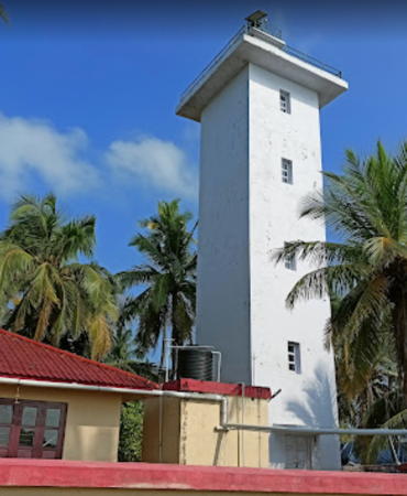
2015 (?) (station established 1993). Active; focal plane 24 m (79 ft); white flash every 5 s. Approx. 22 m (72 ft) square masonry tower. Fasweeh Ullisan's photo is at right, Saakshi Gulati has a view from the sea, and Google has an indistinct satellite view. The original light was on a 12 m (39 ft) square galvanized iron skeletal tower, painted white. Thinnakara is an atoll a few miles north of Agatti; boat transportation from Agatti can be arranged. Site open, tower closed. Admiralty F0754.6; NGA 27598.

Amindivi Islands Lighthouses
* Amini (1)
1984. Inactive. 30 m (98 ft) square galvanized iron skeletal tower, painted with black and white horizontal bands; there is a 1-story concrete equipment room inside the base. the lighthouse was replaced after it was found to be in poor condition. Muhammed Hussain's 2020 photo shows both towers side by side and Google has an indistinct satellite view. Amini is at the southern corner of the Amindivi Islands and is the administrative center for that island group. The island is accessible by a weekly passenger ferry from Cochin. Located near the southern tip of the island. Site open, tower closed.

Thinnakara Light, Agatti,December 2021
Google Maps photo by Fasweeh Ullisan
* Amini (2)
2018 (station established 1984). Active; focal plane 34 m (112 ft); white flash every 5 s. 30 m (98 ft) square galvanized iron skeletal tower, painted with black and white horizontal bands; there is a 1-story concrete equipment room inside the base. Muhammed Hussain's 2020 photo shows both towers side by side and Google has an indistinct satellite view. Located near the southern tip of the island. Site open, tower closed. Admiralty F0754.4; NGA 27596.
 
* Kadamath (Kadmat, Cardamum Island)
1984. Active; focal plane 34 m (112 ft); four white flashes every 20 s. 30 m (98 ft) square skeletal tower with gallery, painted white; there is a 1-story concrete equipment room inside the base. Neil Sequeira has a distant view and Google has a satellite view. This is a sibling of the Amini Light. Kadmat, located about 5 km (3 mi) north of Amini, is about 10 km (6 mi) long, making it one of the largest islands of Lakshadweep. The island is accessible by a weekly passenger ferry from Cochin. Site open, tower closed. ARLHS LAK-005; Admiralty F0754.2; NGA 27592.
* Kiltan South (2)
1976 (station established 1974). Active; focal plane 41 m (134 ft); white flash every 10 s. 41 m (134 ft) round cylindrical concrete block tower with lantern and gallery. Lighthouse painted with horizontal red and white bands. A 2008 photo is at right, a 2020 closeup is available, Aqueeb Javid has a 2023 view, and Bing has a satellite view. Kiltan is the easternmost of the Amindivi Islands, located about 40 km (25 mi) northeast of Kadmat. The island is accessible by passenger ferry from Amini and, less often, from Cochin. A temporary light on a wood skeletal tower was replaced by this substantial lighthouse. Located at the southern tip of the island. Site open, tower closed. ARLHS LAK-008; Admiralty F0754; NGA 27576.
* Kiltan North (3)
2011 (station established 1937). Active; focal plane 16 m (52 ft); two white flashes every 15 s. 15 m (49 ft) square cylindrical brick tower with gallery, painted white. Aflal Hussain has a closeup 2022 photo and Google has a satellite view. The original light, shown from a 6 m (20 ft) mast atop a 9 m (30 ft) masonry base, was the only navigational light in the islands, except for the Minicoy lighthouse, until the Androth East End lighthouse was built in 1967. It was replaced in 1976 by a cylindrical white concrete tower with two galleries. Located on the beach at the extreme northern tip of the island. Site open, tower closed. ARLHS LAK-007; Admiralty F0752; NGA 27572.
Chetlat
1984. Active; focal plane 36 m (118 ft); three white flashes every 30 s. 30 m (98 ft) square galvanized iron skeletal tower, painted with black and white horizontal bands; there is a 1-story concrete equipment room inside the base. A Bing satellite view shows the lighthouse at the base of the pier. Another sibling of the Amini Light. Chetlat is a small, isolated island on the northeast side of the Amindivis. Boat transportation is available about once a week from the other islands. Located by the pier on the west side of the island. Site open, tower closed. Admiralty F0749; NGA 27588.
Bitra (2)
1984 (station established 1977). Active; focal plane 33 m (108 ft); nine quick white flashes every 10 s. 30 m (98 ft) square galvanized iron skeletal tower, painted with red and white horizontal bands; there is a 1-story concrete equipment room inside the base. The tower is hard to find in Google's satellite view. One more Amini class lighthouse. The original light was on a shorter wood skeletal tower. Bitra is a small island in a large atoll on the west side of the Amindivis. Site open, tower closed. ARLHS LAK-003; Admiralty F0750; NGA 27580.
Kiltan South Light
Kiltan South Light, Kiltan, January 2008
Flickr photo copyright praveenlava; permission requested

Information available on lost lighthouses:

Notable faux lighthouses:

Adjoining pages: East: Kerala | South: Maldives

Return to the Lighthouse Directory index | Ratings key

Posted January 16, 2006. Checked and revised July 23, 2023. Lighthouses: 20. Site copyright 2023 Russ Rowlett and the University of North Carolina at Chapel Hill.