Lighthouses of Maldives

The Republic of Maldives (Dhivehi in its own language) occupies a chain of 26 atolls oriented north to south in the Indian Ocean southwest of the southern tip of India. The islands have a population of about 400,000. The islands are quite low, having an average elevation of only 1.5 m (5 ft) above normal high tide. As a result the islands are vulnerable to inundation by rising sea levels associated with global climate change. It's worth mentioning that our word atoll comes from the Dhivehi (Maldivian) atholhu.

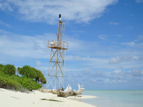
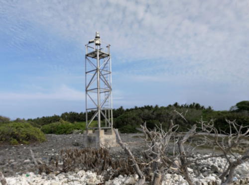
The Maldives have no traditional lighthouses. The major navigational aids of the islands are all small skeletal towers like the one shown at right. Photos of these towers are quite rare on the Internet.

The Dhivehi (Maldivian) name for a lighthouse or beacon is also the word for a fire: 'alifān.

Navigational aids in the Maldives are presumably maintained by the Ministry of Transport and Communications.

ARLHS numbers are from the ARLHS World List of Lights. Admiralty numbers are from volume F of the Admiralty List of Lights & Fog Signals. U.S. NGA List numbers are from Publication 112.

General Sources
Online List of Lights - Maldives
Photos by various photographers posted by Alexander Trabas. The photos for Maldives are by Douglas Cameron and Jim Smith.
World of Lighthouses - Maldives
Photos by various photographers available from Lightphotos.net.
Lighthouses in the Maldives
Photos by various photographers available from Wikimedia.
GPSNauticalCharts
Navigational chart for Maldives.
Navionics Charts
Navigational chart for Maldives.

Thuraakuna Light, Thuraakuna, January 2018
Google Maps street view by ImmA ImraN
Lightbeacons
* [Fiyoari]
Date unknown. Active; focal plane 15 m (49 ft); two white flashes every 20 s. 15 m (49 ft) triangular skeletal mast. The tower is at the left in Nazim Usman's photo but the slender tower does not appear in Google's satellite view. Located at the football field at Fiyoari, a town near the south end of the Gaafu Dhaalu (South Huvadhoo) Atoll, at the southern end of the Maldives archipelago. Site open, tower closed. Admiralty F0768.2.
* [Isdhoo (Isdū)]
Date unknown. Active; 15 m (49 ft); two white flashes every 10 s. 15 m (49 ft) skeletal mast. Aly Ramyz has a photo, but the slender tower is not seen in Bing's satellite view. Located in Isdhoo, a town of about 2000 people at the northeastern tip of the Haddhunmathi atoll. Site open, tower closed. Admiralty F0767.05; NGA 27464.
Vilufushi (Wilifuri)
Date unknown. Active; focal plane 15 m (49 ft); white flash every 5 s. 15 m (49 ft) square skeletal tower mounted on a platform supported by piles. No photo available but Google has a distant satellite view. Located on the reef off Vilufushi, a town of about 1100 people on the Thaa (Kolhumadulu) atoll, 185 km (115 mi) south of Malé. Accessible only by boat. Site open, tower closed. Admiralty F0766.8; NGA 27452.
* Kudahuvadhoo (Kudahavadhoo)
Date unknown. Active; focal plane 15 m (49 ft); two white flashes every 10 s. 15 m (49 ft) square skeletal tower. No photo available but Google has an indistinct satellite view. Located in Kudahuvadhoo, a town of about 3600 people and the district town of the South Nilande atoll, on the south side of the atoll, the next atoll north of Kolhumadulu. Site open, tower closed. Admiralty F0766.4; NGA 27448.
* Raimmandhoo (Raimandu)
Date unknown. Active; focal plane 15 m (49 ft); white flash every 10 s. 15 m (49 ft) square skeletal tower. Ahmed Shaail Nasym's photo is at right and the tower is barely visible in Google's satellite view. Located in Raimmandhoo, a village of about 200 people at the northeast corner of the Mulakatholhu atoll. Site open, tower closed. Admiralty F0766.6; NGA 27436.
Randmandhoo Light
Raimmandhoo Light, Mulak, December 2008
ex-Panoramio Creative Commons photo by Ahmed Shaail Nasym
Maavaru
Date unknown. Active; focal plane 15 m (49 ft); two white flashes every 20 s. 15 m (49 ft) square skeletal tower mounted on a platform supported by piles. No photo available but Google has a distant satellite view. Located on the reef at the southwest corner of the Faafu (Northern Nilandhe) atoll, 65 km (40 mi) southwest of Malé. Accessible only by boat. Site open, tower closed. Admiralty F0766; NGA 27432.
* Gangehi
Date unknown. Active; focal plane unknown; white flash every 5 s. NGA lists a focal plane of 15 m (49 ft), but the light is certainly atop a tall communications tower seen in a view of the islet from the sea. Google has an indistinct satellite view. Located in the midst of the Gangehi Island Resort on an islet near the north end of the large Ari Atoll a short distance west of Malé. Admiralty F0765.2; NGA 27414.
[Malé Entrance Lights]
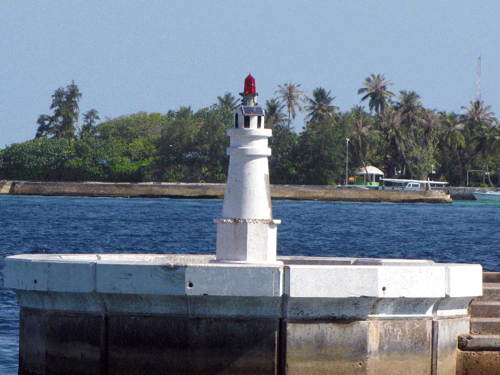
Date unknown. Active; focal plane about 4 m (13 ft); flashing red or green light. Malé is the capital of Maldives and its only city; it has a population of a little over 250,000, half the population of the country. The city occupies the entirety of a small island at the south end of Malé Atoll. A series of breakwaters shelter the harbor on the north side of the island; Google has a satellite view. There are five entrances through the breakwater and each of them is marked by small round towers displaying a red light on the east (port) side of the entrance and a green light on the west side. Trabas has Cameron's and Smith's photos of nearly all of these lights (one is seen at right) and Lightphotos.net also has a photo of the east light at Entrance 4. Additional photos of these lights are available: Ibrham Waheed has a pier view of entrance 1 and a pier view of entrance 2, Ahmed Mujthaba has a street view of entrance 3, and Mohamed Hussain has a pier view of entrance 4 and a pier view of entrance 5. The Admiralty has separate listings for the ten lights but ARLHS and NGA make do with a single listing covering all of them. Sites open, towers closed. ARLHS MAL-001; Admiralty F0765 et seq.; NGA 27412.
Sinamalé Bridge Northwest
2018. ctive; focal plane about 8 m (26 ft); white light, pattern unknown. Approx. 6 m (20 ft) round tower colored with red and yellow horizontal bands. Lightphotos.net has a photo and Chitrita Ghosh has a distant view from the lagoon but the bridge hides the light in Google's satellite view. The Sinamalé Bridge connects Malé to the neighboring island of Hulhulé, the location of the international airport and seaplane terminal. Located on a central foundation pad of the bridge. Accessible only by boat. Not listed by the Admiralty.
Sinamalé Bridge Southeast
2018. ctive; focal plane about 8 m (26 ft); white light, pattern unknown. Approx. 6 m (20 ft) round tower colored with red and yellow horizontal bands. Lightphotos.net has a photo, Ibrahim Zameer has a distant view from the sea, and Google has a distant satellite view. Located on a central foundation pad of the bridge. Accessible only by boat. Not listed by the Admiralty.

Entrance 4 Port Side Light, Male
photo copyright Douglas Cameron; used by permission
* Thuraakuna (Turakuna)
Date unknown. Active; focal plane 15 m (49 ft); white flash every 5 s. 15 m (49 ft) square cylindrical skeletal tower. A photo is at the top of this page, Ibrahim Adeeb has a very distant view and Google has a very distant satellite view. Endangered: Mohamed Hassan's 2021 photo shows the light with a troubling lean. Located at the northwestern tip of Thuraakuna, the northernmost islet and village of Maldives, in the Haa Alif atoll. Site open, tower closed. Admiralty F0762.9; NGA 27394.

Information available on lost lighthouses:

Notable faux lighthouses:

Adjoining pages: North: Lakshadweep | Northeast: Kerala and Karnataka | South: British Indian Ocean Territory

Return to the Lighthouse Directory index | Ratings key

Posted January 30, 2015. Checked and revised July 23, 2023. Lighthouses: 8. Site copyright 2023 Russ Rowlett and the University of North Carolina at Chapel Hill.