Lighthouses of Montenegro

The proper name of this country, Crna Gora, translates as Montenegro in Italian or Black Mountain in English. After being an independent kingdom since at least the 14th century Montenegro became part of Yugoslavia after World War I and remained in federation with Serbia after the collapse of the Yugoslav federation in 1991-92. The country declared its independence from Serbia in June 2006 following a favorable vote in a referendum several weeks earlier.

Montenegro has about 90 km (55 mi) of coastline on the Adriatic Sea between Croatia to the north and Albania to the south. Bar, near the center of this coast, is the chief international port, although there are minor port facilities at Budva in the north and Ulcinj in the south.

The Montenegrin language can be written in either the Latin or Cyrillic alphabets, although the Latin alphabet is now preferred. As in Croatian the word for a lighthouse is svjetionik. The word rt is a cape or promontory, otok or otočić is an island, hrid is a rock, pličina is a shoal, zaljev is a bay, rijeka is a river, and luka is a port.

Aids to navigation are maintained by the Aids to Navigation Division of the Maritime Safety Department (Uprava Pomorske Sigurnosti).

ARLHS numbers are from the ARLHS World List of Lights. MTL numbers are from the Table of Lights, the official Montenegro light list, as provided by the Department for Hydrography and Oceanography, Hydrometeorological Institute of Montenegro. Admiralty numbers are from volume E of the Admiralty List of Lights & Fog Signals. U.S. NGA List numbers are from Publication 113.

General Sources
List of Lights on Montenegro Coast of the Adriatic Sea
The Montenegro Table of Lights, 2013 edition.
Online List of Lights - Montenegro
Photos by various photographers posted by Alexander Trabas. Photos for Montenegro are by Capt. Peter Mosselberger ("Capt. Peter"), Eckhard Meyer, or Philippe Le Bret.
World of Lighthouses - Montenegro
Photos by various photographers available from Lightphotos.net. The Maritime Safety Department's photos are included in this collection.
GPSNavigationCharts
Navigation chart information for Montenegro.
Navionics Charts
Navigation chart for Montenegro.

Bar West Breakwater Light
Bar West Breakwater Light, Bar, August 2008
Flickr Creative Commons photo by Roberto Fuligni

Adriatic Sea Lighthouses
* [Ulcinj (Castle Peak)]
Date unknown. Active; focal plane 27 m (89 ft); white flash every 3 s. 4 m (13 ft) post on a small square equipment cabinet mounted atop the ramparts of the Ulcinj castle. The Maritime Safety Department has a small photo with an aerial view, Trabas has Meyer's distant view, Ali Zigeli has a distant view across the harbor, Alberto de Marco has a very distant view from the town's waterfront, Máté Keczán has a street view from below the castle, and Google has a satellite view. Located at the west entrance to the harbor of Ulcinj, a historic port with a population of about 20,000. Site open, tower closed. ARLHS MNE-007; MTL-789; Admiralty E3698; NGA 14276.
Mendra (Rt Mendra, Cape Mendre, Valdanos)
1886. Active; focal plane 35 m (115 ft); three white flashes every 10 s. 8 m (26 ft) octagonal concrete tower with gallery, painted white and attached to a 2-story keeper's house. The Maritime Safety Department has the closeup photo at right and also an aerial photo, Trabas has Capt. Peter's photo, Lejla Sab has a 2021 photo, and Google has a satellite view. As of 2022 the keeper's house was occupied by a single keeper. This is the oldest lighthouse and the last staffed lighthouse in Montenegro. Located on Rt Mendra, a cape about 5 km (3 mi) northwest of Ulcinj, marking the entrance to Valdanos Bay. Site probably open, tower closed. ARLHS MNE-012; MTL-788; Admiralty E3696; NGA 14272.
Voluvica (Rt Volujica, Antivari) (2)
1879 (station established 1864). Active; focal plane 30 m (98 ft); two white flashes every 10 s. 6 m (20 ft) octagonal cylindrical concrete tower, painted with black and white horizontal bands. Trabas has Capt. Peter's closeup photo, a historic photo is available (1/4 the way down the page), and Google has a satellite view.The first light was described as a "mast above white house." Located on a promontory on the south side of the entrance to the harbor and bay of Bar. Site and tower closed (the light is in a petroleum tank farm). ARLHS MNE-014; MTL-784; Admiralty E3690; NGA 14260.
Bar West Breakwater
Date unknown. Active; focal plane 19 m (62 ft); green flash every 3 s. 13 m (43 ft) round tower with gallery, rising from a small 1-story equipment room. Entire lighthouse is white. Roberto Fuligni's photo is at the top of this page, the Maritime Safety Administration has a photo and an aerial photo, Trabas has Le Bret's photo, Alehandro Sanchez has a view from the sea, and Google has a street view and a satellite view. Bar is a seaport with a population of about 13,000. Ferries connect it to Bari, Italy, and Italians sometimes call the town Antibari. Located at the end of the main breakwater marking the entrance to the harbor of Bar. The breakwater is about 1400 m (7/8 mi) long and does not appear to be walkable. Site and tower closed. MTL-785; Admiralty E3691; NGA 14268.
Rt Mendra Light
Rt Mendra Light, Ulcinj, October 2005
Montenegro Maritime Safety Department photo
* [Bar North Breakwater]
Date unknown (station established 1872). Active; focal plane 6 m (20 ft); two red flashes every 5 s. 5.5 m (16 ft) post painted with red and white horizontal bands. Trabas has Le Bret's photo, Milan Filipovic has a 2021 photo, and Google has a street view and a satellite view. Located at the end of the north breakwater of Bar; accessible by walking the pier from the marina. Site open, tower closed. MTL-786; Admiralty E3693; NGA 14269.
Bar Marina North Mole
Date unknown. Active; focal plane 7 m (23 ft); green flash every 5 s. 5 m (17 ft) round cylindrical tower painted with black and white horizontal bands. Trabas has Capt. Peter's photo, Arkadiusz Wyrembak has a street view, and Google has an indistinct satellite view. Located at the end of the Marina's north (really west) mole, which is attached to the Bar North Breakwater. Site open, tower closed. MTL-786.5; Admiralty E3694.
* Bar Marina South Mole
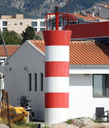
Date unknown. Active; focal plane 6 m (20 ft); red flash every 5 s. 6 m (20 ft) round cylindrical tower painted with red and white horizontal bands. Trabas has Capt. Peter's photo and Google has an indistinct satellite view. Located at the end of the Marina's south (really east) mole. Accessible by walking the pier. Site open, tower closed. MTL-786.6; Admiralty E3694.1.
[Rt Crni (Black Cape)]
Date unknown. Active; focal plane 142 m (466 ft); white flash every 4 s. 4 m (13 ft) round cylindrical concrete (?) tower with lantern, painted white; the lantern roof is black. Trabas has Le Bret's photo and Google has a satellite view. Located on the cape at the northern entrance to the bay of Bar, about 8 km (5 mi) northwest of the city. There is a road to the site but it may not be open to the public. Site status unknown. MTL-783.5; Admiralty E3689; NGA 14256.
Sveti Nikola (Otočić Sveti Nikola)
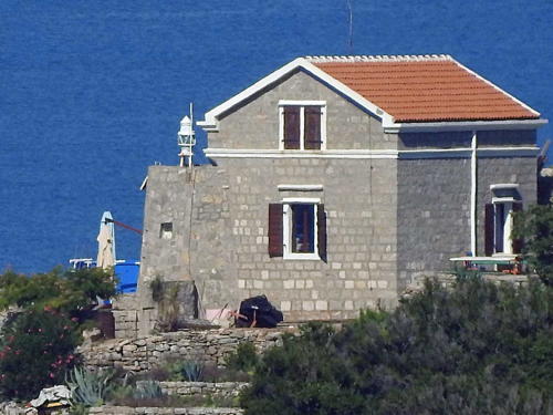
Date unknown (station established 1882). Active; focal plane 23 m (75 ft); three white flashes every 10 s. 4 m (13 ft) hexagonal unpainted stone tower attached to a 1-1/2 story stone keeper's house. Trabas has Capt. Peter's closeup photo (also seen at right) and Google has a satellite view of the station. Otočić Sveti Nikola is an island rising dramatically from the bay of Budva. Located at the southeastern point of the island, about 3 km (1.8 mi) southeast of Budva. Site status unknown. ARLHS MNE-010; MTL-783; Admiralty E3686; NGA 14244.
* Platamon (Rt Platamon, Punta Platamuni)
Date unknown. Active; focal plane 32 m (105 ft); white flash every 6 s. 10 m (33 ft) round stone column with gallery, mounted on a small 1-story hexagonal stone equipment room. The lighthouse is unpainted white stone; the small lantern is red. Trabas has Capt. Peter's closeup photo, Aleksei Pobalkanim has a 2023 photo, Ruslan Litvin has a street view from the shore and Google has a satellite view. A long flight of stone steps leads from the lighthouse down to the sea. Located on Rt Platamon, a promontory at the western entrance to the bay of Budva, about 2.5 km (1.5 mi) west of the port. There appears to be road access to this site, but we do not know if the area is open to the public. Site status unknown. ARLHS MNE-013; MTL-778; Admiralty E3685; NGA 14240.
Mamula (Otočić Mamula) (1)
Date unknown. Inactive. Approx. 15 m (49 ft) square brick tower mounted atop a large round fortification. The fort is unpainted white stone; the 4 m (13 ft) light tower is unpainted red brick. The light (focal plane 35 m (115 ft); white flash every 3 s) has been moved from the brick tower to a white iron pole. Dmitry Zaitsev has a photo, Trabas has Capt. Peter's photo, Milica Matijević has a photo, Pavel Veličko has a street view from outside the fort, and Google has a good satellite view. This light and the light on Rt Ostra, Southern Croatia, frame the entrance to the Bay of Kotor. Located on an island to the east of the entrance channel for Tivatski Bay, the southernmost portion of the Bay of Kotor. Accessible only by boat. Site status unknown. ARLHS MNE-001; Active light: MTL-743; Admiralty E3622; NGA 14104.

Sveti Nikola Light, Budva
photo copyright Capt. Peter Mosselberger; used by permission

Bay of Kotor Lighthouses
The Bay of Kotor (Boka Kotorska) is a picturesque, fjord-like bay, ringed by mountains, at the northwestern corner of Montenegro. The bay is connected to the Adriatic by a narrow inlet on the Montenegro-Croatia border, but the rest of the bay is in Montenegrin territory.

Tunja (Pličina Tunja)
Date unknown. Active; focal plane 8 m (26 ft); two flashes every 5 s, white or red depending on direction. 7 m (23 ft) square pyramidal stone tower, mounted on a small 1-story stone equipment room. The lighthouse is unpainted white stone. Trabas has Capt. Peter's photo, a 2007 photo is available, and Bing has a satellite view. Located off the northwestern end of the island of Tunja in Tivatski Bay, the southernmost portion of Bay of Kotor, about 2 km (1.2 mi) southwest of Tivat. Accessible only by boat. Site open, tower closed. MTL-752; Admiralty E3645; NGA 14140.
* Rt Seljanovo
Date unknown. Active; focal plane 7 m (23 ft); red flash every 3 s. 6 m (20 ft) round cylindrical tower painted with red and white horizontal bands. Trabas has Le Bret's photo, Nebojsa Ilic has a 2017 photo, Julia Pateichuk has a street view, and Google has a satellite view. Located on a sharp point of land projecting into Tivatski Bay at Seljanovo. Site open, tower closed. MTL-756; Admiralty E3638; NGA 14156.
* Opatovo (Rt Opatovo) (2)
1904 (station established 1878). Active; focal plane 9 m (30 ft); green flash every 2 s. 8 m (26 ft) square stone column with gallery, mounted on a small 1-story stone equipment room. The lighthouse is unpainted white stone. Trabas has Rainer Arndt's photo and Google has a satellite view. Located on the east side of the southern entrance to the narrow Verige Strait, which connects the outer and inner basins of the bay through a water gap in the mountains, about 2.5 km (1.5 mi) northwest of Tivat. The E65 highway passes very close to the lighthouse. Site open, tower closed. ARLHS MNE-006; MTL-759; Admiralty E3654; NGA 14168.
* Gospa (Rt Gospa, Cape Verige)
Date unknown. Active; focal plane 10 m (33 ft); green flash every 3 s. 6 m (20 ft) post mounted on a square concrete pedestal. Trabas has Capt. Peter's photo, Villa Micika Dubrovnik has a street view, and Google has a satellite view. The light stands next to a ruined stone chapel. Located on the east side of the northern entrance to the Verige Strait. The E65 highway passes very close to the lighthouse. Site open, tower closed. ARLHS MNE-005; MTL-763; Admiralty E3660; NGA 14184.
* Turski (Rt Turski)
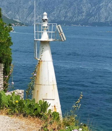
1910. Active; focal plane 9 m (30 ft); two white flashes every 5 s. 8 m (26 ft) round, strongly conical cast iron tower, painted white. A 2023 photo is at right, Alberto De Marco has a 2008 photo, Trabas has Le Bret's photo, Pavle Obradovic has a sea view, Raj Thiagaraj has a closeup street view, and Google has a satellite view. Located on Rt Turski, the point of land on the west side of the northern entrance to the Verige Strait, about 6 km (3.5 mi) north of Tivat. The E65 highway passes very close to the lighthouse. Site open, tower closed. ARLHS MNE-004; MTL-762; Admiralty E3658; NGA 14180.
* Rt Sveti Nedlja (Rt Verige)
Date unknown (station established 1878). Active; focal plane 7 m (23 ft); red flash every 2 s. 7 m (23 ft) round cylindrical cast iron tower, painted with red and white horizontal bands. Trabas has Meyer's photo, Pavle Obradovic has a sea view, Evgeny Goroshko has a street view, and Google has a satellite view. Located on the west side of the southern entrance to the narrow Verige Strait. Site open, tower closed. MTL-758; Admiralty E3652; NGA 14164.

Turski Light, Tivat, July 2023
Google Maps photo by Ewa Ewa

Information available on lost lighthouses:

Notable faux lighthouses:

Adjoining pages: North: Southern Croatia | South: Albania

Return to the Lighthouse Directory index | Ratings key

Posted October 10, 2006. Checked and revised November 21, 2023. Lighthouses: 13. Site copyright 2023 Russ Rowlett and the University of North Carolina at Chapel Hill.