Lighthouses of Albania

The Republic of Albania (Shqipëria in Albanian) faces west on the Adriatic Sea and Strait of Otranto south of Montenegro and north of Greece. The country gained its independence from the Ottoman (Turkish) Empire in 1912. During World War II (1939-1943) it was occupied first by Italian forces and then by German forces after Italy's surrender. After the war it was governed by a repressive Communist dictatorship and generally closed to visitors, an isolation that came to an end after the Communists were pushed out of power in 1992. Although it remains one of Europe's least known countries tourism is developing rapidly, especially on the southern coast. Durrës and Vlorë are the major ports.

Although Western Europeans have called the country Albania since the Middle Ages, the official name is Shqipëria. The country is divided into 12 counties (qarqet) and the counties are subdivided into municipalities.

At various times in the past the Albanian language has been written in all the major scripts of the region including Greek, Cyrillic, and Arabic, but since 1908 it has been written in the Latin script with the addition of the letters ë and ç. The Albanian word for a lighthouse is far; kep is a cape, sqepi ("beak") is a headland, gji is a bay, ishull is an island, lumi is a river, and port is a port or harbor.

Historically many locations in Albania were better known by their Italian names, shown in curly brackets {}.

Aids to navigation in Albania are maintained by the hydrographic division of the Albanian Naval Force (Forca Detare). Under a 2004 agreement between Albania and Italy the Italian Navy has provided technical and equipment assistance to Albania in upgrading its aids to navigation.

Information on Albanian lighthouses is very scarce so reports and photos from visitors would be welcome.

ARLHS numbers are from the ARLHS World List of Lights. Admiralty numbers are from volume E of the Admiralty List of Lights & Fog Signals. U.S. NGA List numbers are from Publication 113.

General Sources
Online List of Lights - Albania
Photos by various photographers posted by Alexander Trabas. Nearly all of the photos for Albania are by Eckhard Meyer or by Capt. Peter Mosselberger ("Capt. Peter").
World of Lighthouses - Albania
Photos by various photographers available from Lightphotos.net.
Navionics Charts
Navigation chart for Albania.

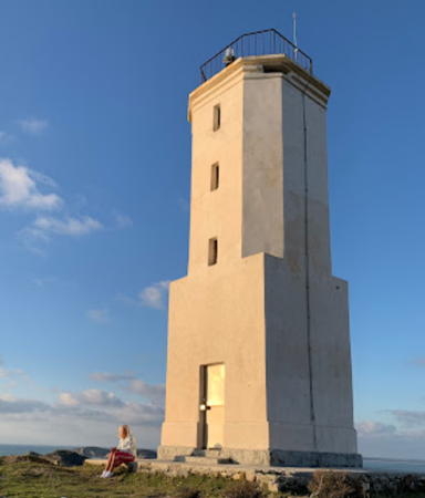
Kep i Treporteve Light, Vlorë, February 2021
Google Maps photo by Vitali Nikulenka

Vlorë County Lighthouses

Sarandë Lighthouses
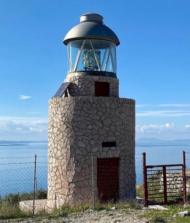
* Sarandë (Gjiri Sarandës, Lëkurës) {Santi Quaranta} (2?)
2010. Active; focal plane 215 m (705 ft); three white flashes every 30 s. 8 m (26 ft) round cylindrical rubblestone tower with an aluminum lantern. Leonard Xhaxho's photo is at right, Trabas has Capt. Peter's closeup photo, Peter Black has a 2021 closeup photo and Google has a satellite view. This lighthouse is a short distance south of the 16th century Lëkurësi Castle, now the site of a popular restaurant. Located on the heights above Sarandë (Saranda), a port and tourist center facing the north end of the Greek island of Kérkyra (Corfu). Site open, tower closed. Admiralty E3742.3.
* [Kepi i Feruc]
2019. Active; focal plane 6 m (20 ft); white flash every 3 s. 4 m (13 ft) post painted with red and white horizontal bands. Trabas has Meyer's photo and Google has an indistinct satellite view. The light was formerly painted with black and white bands as seen in Sam Bell's 2017 street view. Located on the waterfront of Sarandë. Site open, tower closed. Admiralty E3741.5.

Lukovë Lighthouse
Kep i Qefalit (Cape Kefali) (1)
Date unknown. Inactive at least since 2020. Approx. 12 m (39 ft) square tower rising from a keeper's house. Trabas has Meyer's very distant view and Google has a satellite view of the station. In 2020 the Admiralty announced a new light (focal plane 155 m (509 ft); white flash every 5 s) on an 8 m (26 ft) mast. The light marks the north side of the entrance to the Kerkyra Strait separating the Greek island of Kerkyra (Corfu) from Albania and the Greek mainland. Located atop a precipitous cape about 25 km (15 mi) northwest of Sarandë. Site status unknown. Active light: Admiralty E3741; NGA 14372.

Himarë Lighthouses
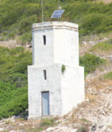
Kep i Palermos {Porto Palermo}
Date unknown. Active; focal plane 113 m (371 ft); white flash every 8 s. 10 m (33 ft) two-stage white concrete tower, lower half square and upper half octagonal. Trabas has Meyer's photo, Lightphotos.net has a closeup photo and a view from the sea, and Google has a satellite view. Located on a prominent cape about 15 km (9 mi) southeast of Himarë. Site status unknown. ARLHS ALB-001; Admiralty E3734; NGA 14368.
Himarë Bay (Bay of Palermo)
2017. Active; focal plane 32 m (105 ft); four white flashes every 12 s. 12 m (39 ft) white concrete tower. Trabas has Meyer's photo, a drone view is available and Google has a satellite view. Better known by its Italian name Porto Palermo, the bay of Himarë is a rare protected anchorage on a rugged coast. Located on a headland at the head of the bay. Site status unknown. Admiralty E3733.8.
Sarandë Light
Gjiri Sarandës Light, Sarandë, July 2010
ex-Panoramio photo copyright Leonard Xhaxho; permission requested
* [Himarë]
2008. Active; focal plane 8 m (26 ft); three white flashes every 8 s. 6 m (20 ft) round white tower. Trabas has Capt. Peter's photo and Google has an indistinct satellite view. Located on the dock at Himarë. Site open, tower closed. Admiralty E3733.5.

Orikum (Karaburan Peninsula) Lighthouses
* [Kep i Gjuhezes (2?)]
Date unknown. Active; focal plane 58 m (190 ft); white flash every 6 s. Approx. 8 m (26 ft) mast adjacent to a ruined square foundation and a round concrete bunker. Trabas has Capt. Peter's photo and Google has an indistinct satellite view. Located on the northwestern tip of the Karaburun ("Black Cape") peninsula, south of Sazan Island. Site open. ARLHS ALB-008; Admiralty E3732.5; NGA 14338.
[Sqepi Gallovecit (Kep i Gallovecit, Garlovez) (2?)]
Date unknown. Active; focal plane 18 m (59 ft); green flash every 3 s. 6 m (20 ft) skeletal mast standing on a large concrete foundation. Trabas has Capt. Peter's view from the sea and Google has an indistinct satellite view. It seems likely the foundation formerly held a more substantial lighthouse. Located on the northern tip of the Karaburun peninsula, south of Sazan Island. Site status unknown. Admiralty E3728; NGA 14340.
Sqepi i Sevasinit (Shen Vasilit)
Date unknown. Active; focal plane 75 m (246 ft); three white flashes every 8 s. 6 m (20 ft) octagonal cylindrical stone tower, unpainted. A 2022 view is available, Trabas has Capt. Peter's distant view, and Google has a street view and a satellite view. Located on a rugged east coast of the Karaburun peninsula about 8 km (5 mi) north of Orikum on the west side of the Gji i Vlorës. Site status unknown; an unsealed road passes the lighthouse but it looks like a steep climb up to the tower. ARLHS ALB-015; Admiralty E3732; NGA 14352.
Gji Dukatit (Kep i Pasha Liman, Sqepi Orikum)
Date unknown. Active; focal plane 21 m (69 ft); two white flashes every 5 s. 8 m (26 ft) square masonry tower with gallery, painted white. Trabas has Capt. Peter's photo, the light can be seen atop the promontory on the left in Emil Terpini's distant view, and Google has a satellite view. Located on a headland sheltering the Pashaliman Naval Station in Orikum, at the southern end of the Gji i Vlorës. Site status unknown. ARLHS ALB-013; Admiralty E3731; NGA 14360.

Vlorë (Valona) Lighthouses
Vlorë is a city of about 190,000 on the east of Vlorë Bay, sheltered by the Karaburan Peninsula. Its harbor is the terminal for ferries crossing the Strait of Otranto from Brindisi, Italy. The name of the city is often spelled Vlora in English.

*
Kep i Kalaja (Kalase, Kepi i Kalas)
Date unknown (station established 1864). Active; focal plane 44 m (144 ft); one long (1.5 s) white flash every 10 s. 6 m (20 ft) square masonry tower; the lower portion of the tower is open under graceful arches. Tower painted white. A portion of a Google street view is at right, Trabas has Capt. Peter's closeup photo and Google has a satellite view. Located on a precipitous headland in downtown Kalaja, on the south side of Vlorë. Site open, tower closed. Admiralty E3729.5; NGA 14351.

Kep i Kalaja Light, Kalaja, May 2016
Google Maps street view
#Vlorë East Mole
Date unknown. Apparently removed in 2022. This was a 6 m (20 ft) round cylindrical concrete tower with gallery. Entire lighthouse was green. Altin Toska has a closeup 2021 street view and Alexander Zafiriou has a very distant view. The mole has been removed; Trabas has Meyer's photo of an offshore light placed near the former end of the mole and Google has a satellite view. Located at the end of the east breakwater of Vlorë. Site status unknown. Admiralty E3729; NGA 14348.
Vlorë West Mole
Date unknown. Active; focal plane 10 m (33 ft); red flash every 3 s. 8 m (26 ft) round cylindrical concrete tower with gallery. Entire lighthouse is red. Trabas has Capt. Peter's closeup photo, another photo (third photo on the page) is available and Google has an indistinct satellite view. Located at the end of the west breakwater of Vlorë. Site status unknown. Admiralty E3728.9; NGA 14350.
Petrolifera
Date unknown. Active; focal plane 18 m (59 ft); white flash every 3 s. 15 m (49 ft) round white concrete tower with a stairway spiralling around the tower. Trabas has Meyer's photo, a drone view is available, and Google has a street view and a satellite view. Located in the Petrolifera oil terminal north of the main harbor in Vlorë. Site status unknown. Admiralty E3727.8.
Triporti South Breakwater
Date unknown. Active; focal plane 8 m (26 ft); two red flashes every 6 s. 6 m (20 ft) round bottle-shaped stone tower. Tower unpainted, gallery painted red. Trabas has Capt. Peter's closeup photo and Google has a satellite view and a very distant street view. NGA calls this the west breakwater. Located at the end of the south breakwater at a small harbor about 6 km (3.5 mi) northwest of the main Vlorë harbor. Accessible by walking the pier. Site open, tower closed. Admiralty E3727.7; NGA 14347.
Triporti North Breakwater
Date unknown. Active; focal plane 8 m (26 ft); two green flashes every 6 s. 6 m (20 ft) round bottle-shaped stone tower. Tower unpainted, gallery painted green. Trabas has Capt. Peter's closeup photo (also seen at right) and Google has a satellite view and a distant street view. NGA calls this the east breakwater. Located at the end of the north breakwater at a small harbor about 6 km (3.5 mi) northwest of the main Vlorë harbor. Accessible by walking the pier. Site open, tower closed. Admiralty E3727.6; NGA 14346.
Kep i Treporteve (Sqepi i Treporteve)
Date unknown. Active; focal plane 18 m (59 ft); white flash every 5 s. 10 m (33 ft) 2-stage stucco-covered stone tower; upper portion octagonal, lower portion square. The lighthouse is unpainted. A building near the lighthouse may be a keeper's house. Vitali Nikulenka's 2021 closeup photo is at the top of this page, Mario Ibáñez has a 2019 closeup photo, Trabas has Capt. Peter's closeup photo, a 2022 photo is available, Teo Soumpasis has a nice view of the station, and Google has a satellite view. Located on the northeast side of the entrance to the Gji i Vlorës, about 8 km (5 mi) east of Sazan Island and the same distance northwest of Vlorë. Site status unknown. ARLHS ALB-007; Admiralty E3727; NGA 14344.

Triporti North Breakwater Light, Vlorë
photo copyright Capt. Peter Mosselberger; used by permission

Sazan Island Lighthouses
Sazan Island, known as Saseno in Italian, is located strategically in the mouth of the Gji i Vlorës, Vlorë Bay. The island was occupied by Britain after the Napoleonic Wars and administered as part of Britain's Ionian Islands protectorate. In 1864 it was ceded to Greece, but since the Greeks did not occupy it the Ottomans did so, building a lighthouse in 1871. Greece finally took over the island in 1912, but ceded the island to Italy after World War I. Sazan was occupied by Albanian partisans in 1944 and Albanian ownership was confirmed in 1947. The island is administered as part of Vlorë Municipality. According to Wikipedia it is a military exclusion zone.

Ishull i Sazanit (Sazan Island) {Saseno} (2?)
Date unknown (station established by the Ottoman Empire in 1871). Inactive. 12 m (39 ft) octagonal tower attached to a 2-story keeper's house; lantern removed. A distant view from the sea is available, Trabas has Capt. Peter's distant view, and Bing has a satellite view. The Italian Wikipedia article for Saseno states that this lighthouse was built by Italy. Located atop a steep slope on the northwestern side of the island. Accessible only by boat, and the island, site of a former Soviet air base, is a restricted military area. Site and tower closed. ARLHS ALB-004.
Ishull i Sazanit (Sazan Island) (3?)
Date unknown (station established 1871). Active; focal plane 193 m (633 ft); white flash every 10 s. Approx. 15 m (49 ft) square cylindrical skeletal tower. Trabas has Capt. Peter's distant view and the tower is at the left edge of a 2022 photo. Located adjacent to the historic lighthouse. Admiralty E3723; NGA 14328.
Shën Kollit (Shen Nokole) North Mole
Date unknown. Active; focal plane 8 m (26 ft); green flash every 4 s. 6 m (20 ft) round metal tower, painted green, centered on a square 1-story stone equipment shelter. Alban Midha has a 2020 photo, Vitali Nikulenka has a 2021 view from the sea, the light is at far left in an aerial photo of the harbor by Aldo Brokaj, Trabas has Meyer's extremely distant view, and Google has a satellite view. Located at the end of the north (main) breakwater of the Sazan Island harbor, on the east side of the island. Site status unknown. Admiralty E3725; NGA 14332.
Shën Kollit (Shen Nokole) South Mole
Date unknown. Active; focal plane 8 m (26 ft); red flash every 4 s. 6 m (20 ft) round metal tower, painted red, centered on a square 1-story stone equipment shelter. Oleg Strilkov has a view across the harbor, the light is on the shorter breakwater in an aerial photo of the harbor by Aldo Brokaj, Trabas has Meyer's extremely distant view, and Google has a satellite view. Located at the end of the short south breakwater of the Sazan Island harbor. Site status unknown. Admiralty E3726; NGA 14336.
Kep i Jugor
Date unknown. Active; focal plane 18 m (59 ft); white flash every 6 s. 8 m (26 ft) square cylindrical stone tower. The lighthouse is unpainted. Trabas has Capt. Peter's photo (also seen at right), a 2020 photo and a 2021 photo are available, and Bing has a satellite view. Located on the southern tip of Sazan Island. Accessible only by boat. Site status unknown. Admiralty E3726.5; NGA 14337.

Kep i Jugor Light, Sazan Island
photo copyright Capt. Peter Mosselberger; used by permission

Fier County Lighthouses

Fier Lighthouses
Vjosë (Vijose, Lumi i Vjosë) (1)
Date unknown. Inactive. An abandoned round masonry tower, at least 15 m (49 ft) tall. Endangered and leaning. No photo available but Google's satellite view shows it on the beach. Curiously, there doesn't seem to be any record of the old tower being used as a lighthouse, but it's hard to imagine that it's anything else. More information is needed! Located just north of the Vjosë River entrance near Bishan. Site open, tower closed. ARLHS ALB-011.
Vjosë (Vijose, Lumi i Vjosë) (2) (?)
Date unknown. Inactive since 2020. 10 m (33 ft) square skeletal tower, painted white. No photo available but Google has a distant satellite view. The light was probably removed because it was about to succumb to beach erosion (and it may have done so). Located about 80 m (260 ft) south of the old tower. Site open, tower closed. ex-Admiralty E3721; NGA 14324.

Tiranë County Lighthouse

Kavajë Lighthouses
Karavastase
Date unknown. Active; focal plane 19 m (62 ft); white flash every 8 s. Approx. 12 m (39 ft) square skeletal communications tower. Trabas has Meyer's photo and Google has a satellite view. Located on an irrigation dam about 35 km (22 mi) north of Kep i Lagit. Site status unknown. Admiralty E3720; NGA 14322.
Kep i Lagit (1)
Date unknown. Inactive. Approx. 8 m (26 ft) octagonal cylindrical white stone or concrete tower. KavajaOnline.com has a photo and Google has an indistinct satellite view. Kep i Lagit is the promontory at the south end of the Gji i Durrësit (Durres Bay), about 15 km (9 mi) across the bay due south of Durrës. Located on the point of the cape. Site status unknown. ARLHS ALB-014.
[Kep i Lagit (2)]
Date unknown. Active; focal plane 71 m (233 ft); one long white flash every 6 s). 3 m (10 ft) round white concrete tower. Trabas has Capt. Peter's photo and Google satellite view. The light has been moved to a much higher location. NGA still has the focal plane, 20 m (66 ft), of the original tower. Located about 200 m (220 yd) upslope from the front light. Site status unknown. Admiralty E3719; NGA 14320.

Durrës County Lighthouses

Durrës Lighthouses
Durrës is a city of about 250,000 residents, the second largest city of Albania and a major port; ferries arrive here from Bari, Barletta, and Ancona in Italy.
Durrës East Mole
Date unknown. Active; focal plane 9 m (30 ft); green flash every 5 s. 8 m (26 ft) round cylindrical concrete tower mounted on a large square concrete base. Tower painted green. Trabas has Capt. Peter's distant photo and Google has a satellite view. Located at the end of the east breakwater. Site status unknown. Admiralty E3714; NGA 14316.
Durrës South Mole
Date unknown. Active; focal plane 9 m (30 ft); red flash every 5 s. 8 m (26 ft) round cylindrical concrete tower mounted on a large square concrete base. Tower painted red. Trabas has Capt. Peter's distant photo and Google has a satellite view. Located at the end of the breakwater quay of Durrës harbor. Site status unknown. Admiralty E3712; NGA 14312.
* Kep i Durrësit (Durrës) {Durazzo}
Date unknown (station established 1864). Active; focal plane 126 m (413 ft); two white flashes every 10 s. 14 m (46 ft) octagonal cylindrical stone tower with gallery. The lighthouse is unpainted white stone. Tim Partlett's photo is at right, Trabas has Capt. Peter's closeup photo, Michele Cianella has a 2021 photo, Hermann Rorschach has a 2023 photo, Jakub Krawczuk has a street view (a portion is seen at right), Lightphotos.net has a distant view, and Bing has a satellite view. Kep i Durrësit (Cape Durres) is a headland sheltering the harbor of Durrës, Albania's principal port of entry. Located on the heights above the palace of King Zog I, which is one of the best known attractions in Durrës; visitors report it is possible to walk a short distance uphill from the palace to find the lighthouse. Site open, tower closed. ARLHS ALB-002; Admiralty E3711; NGA 14304.
Kep i Palit (Bishti i Pallës, Cape Pali)
Date unknown. Active; focal plane 32 m (105 ft); white flash every 10 s, alternately red and white. 14 m (46 ft) square stone tower. Trabas has Meyer's photo and Google has a satellite view. The Albanian Naval Force has a base at an artificial harbor in the lee of the cape. Located on a sharp promontory on the northwest side of Durrës. Site and tower closed (military base). Admiralty E3708; NGA 14300.
* [Kep i Rodonit (Cape Rodoni) (4?)]
2007 (station established 1884). Active; focal plane 40 m (131 ft); two white flashes every 10 s. 3 m (10 ft) light mounted on a short mast. Marin Kolega has a photo but the tiny light is not seen in Bing's satellite view of the cape. Formerly NGA listed a 10 m (33 ft) skeletal tower, painted white, and earlier lists included a 10 m (33 ft) white "column." Rodonit is a sharp, mountainous cape that projects about 8 km (5 mi) into the Adriatic Sea in northern Albania. We need more information on this historic light station; we don't know if anything survives of the Ottoman lighthouse. Located on the heights above the cape. Accessible by a hiking trail. Site open, tower closed. ARLHS ALB-016; Admiralty E3705; NGA 14296.

Kep i Durrësit Light, Durrës, September 2018
Google Maps street view by Jakub Krawczuk

Lezhë County Lighthouses

Lezhë Lighthouses
Talej
Date unknown. Active; focal plane 15 m (49 ft); white flash every 6 s. Approx. 5 m (16 ft) sqaure white tower mounted on the roof a hydrelectric power station. Trabas has Meyer's photo and Google has a satellite view. Located at Tale, about 25 km (15 mi) north of Cape Rodoni. Site status unknown. Admiralty E3704; NGA 14292.
Kep i Shengjinit (Cape Shengjin, St. Giovanni Point) (2?)
Date unknown. Active; focal plane 24 m (79 ft) (?); red flash every 5s. Approx. 8 m (26 ft) post atop a 2-story building. Although NGA describes a black square tower the building is painted white. Jerzy Lange has a street view and Google has a satellite view. The listed focal plane is too high. Located on a cape sheltering the harbor of Shëngjin, a town about 20 km (13 mi) east southeast of the Montenegrin border. Site status unknown. ARLHS ALB-017; Admiralty E3702.3; NGA 14280.
Mali Renzit
Date unknown. Active; focal plane 46 m (151 ft); white flash every 5s. 16 m (52 ft) post atop a 4-story building. Trabas has Meyer's closeup photo, Jerzy Lange has a distant street view, and Google has a distant satellite view. The Admiralty renumbered this light in 2020. Located on the hillside above the cape sheltering the harbor of Shëngjin. Site status unknown. Admiralty E3702 (ex-3702.5); NGA 14282.

Information available on lost lighthouses:

Notable faux lighthouses:

Adjoining pages: North: Montenegro | East: North Macedonia | Southeast: Northern Greece | South: Ionian Islands

Return to the Lighthouse Directory index | Ratings key

Posted October 12, 2006. Checked and revised November 13, 2023. Lighthouses: 30. Site copyright 2023 Russ Rowlett and the University of North Carolina at Chapel Hill.