Lighthouses of Mauritius

The Republic of Mauritius is an island nation in the South Indian Ocean roughly 1000 km (600 mi) east of Madagascar. The nation includes the major island of Mauritius itself as well as the smaller island of Rodrigues and several remote islets. Discovered by the Portuguese in 1505, the island was first settled by the Dutch in 1638 and still bears its Dutch name. The Dutch colony was abandoned in 1710. French settlers replaced the Dutch in 1715 and held the island until British forces seized it in 1810. After a century and a half of British rule the Republic of Mauritius became independent in 1968. The country has a population of about 1.25 million.

In 1965 Britain removed the Chagos Archipelago from its Mauritius colony to establish it as the British Indian Ocean Territory. Mauritius continues to claim the Chagos.

Despite the lengthy British connection a French-based Creole language is commonly spoken and most place names are French. In French phare is the word for a lighthouse, île is an island, cap is a cape, pointe is a promontory or point of land, roche is a rock, récife is a reef, baie is a bay, estuaire is an estuary or inlet, détroit is a strait, rivière is a river, and havre is a harbor.

Lighthouses in Mauritius are maintained by the Mauritius Ports Authority.

ARLHS numbers are from the ARLHS World List of Lights. Admiralty numbers are from volume D of the Admiralty List of Lights & Fog Signals. U.S. NGA List numbers are from Publication 112.

General Sources
Phares d'Afrique
A section of Le phare à travers le monde, the web site of Alain Guyomard and Robert Carceller; there are links to several pages on Mauritian lighthouses.
Online List of Lights - Mauritius and Rodrigues
Photos by various photographers posted by Alexander Trabas. The Mauritius photos are by Erich Hartmann.
Lighthouses in Mauritius
Photos by various photographers available from Wikimedia.
World of Lighthouses - Mauritius
Photos by various photographers available from Lightphotos.net.
Afrikanische Leuchttürme auf historischen Postkarten
Historic postcard views posted by Klaus Huelse.
GPSNauticalCharts
Navigational chart information for Mauritius.
Navionics Charts
Navigational chart for Mauritius.

Pointe aux Caves Light, Port Louis, March 2024
Instagram photo by Noeriena Hendricks
Mauritius Lighthouses
*** Pointe aux Caves (Albion)
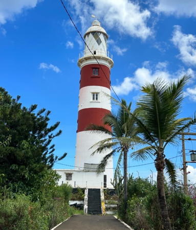
1910. Active; focal plane 46 m (151 ft); two white flashes every 10 s; there is also a continuous red passing light at a focal plane of 30 m (98 ft). 30 m (98 ft) masonry tower with lantern and gallery. Lighthouse painted white with two red horizontal bands. A 2024 photo by Noeriena Hendricks is at the top of this page, Guyomard and Carceller have several photos by Eric Valenne and Jean-Michel Penin, Ramjheetun Elodie has another good photo, there are photos taken from the gallery, Gordon Greeff has a closeup, Wikimedia has a photo, Paul Darne has a 2021 photo, Trabas has Hartmann's view from the sea, Jay Seenundun has a street view from the beach, Huelse has a historic postcard view, and Google has a satellite view. A handsome, very British lighthouse in the tropical Indian Ocean; it replaced a lightship station established in 1867. Locally it is usually called the Phare d'Albion. Located on a headland about 10 km (6 mi) southwest of Port Louis, the national capital. Accessible by road. Site open, tower open by arrangement with the attendant. . ARLHS MAT-004; Admiralty D7096; NGA 32852.
* Pointe aux Sables
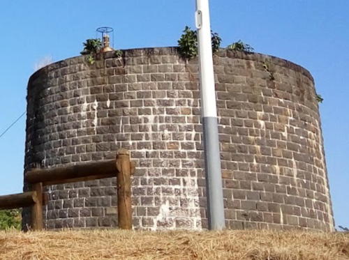
Date unknown. Active; focal plane 24 m (79 ft); white light 1 s, off 1 s, green light 1 s, off 1 s. 12 m (39 ft) black stone Martello tower with two vertical white stripes. No lantern; the light is mounted on the top front of the tower. Pazhanivela Ramassami has the 2017 photo at right, Guyomard and Carceller have a photo by Jean-Michel Penin, Andres Stuyck has a fine photo, and Google has a satellite view. Martello towers are round stone fortifications built during the early nineteenth century to repel attacks from the sea. This is one of five Martello towers the British built on Mauritius after they took the island from the French in 1810; two of the five were converted later into aids to navigation. Located on the B31 highway, on the west side of the entrance to the old harbor of Port Louis at the mouth of the Black River. Accessible by road. Site open, tower closed. ARLHS MAT-006; Admiralty D7097; NGA 32872.
Port Louis Range Front
Date unknown. Active; focal plane 39 m (128 ft); red light, 7.5 s on, 2.5 s off. Approx. 33 m (108 ft) triangular steel skeletal tower, painted with red and white horizontal bands. Trabas has Hartmann's photo, Bhugon Jean Francois has a view from across the harbor, Guy Bouvier has a view from the water, and Google has a satellite view. Located on Quay A on the Port Louis waterfront. Site and tower closed. ARLHS MAT-007; Admiralty D7101; NGA 32861.
* Port Louis Sector (Range Rear)
Date unknown (2005?). Active; focal plane 69 m (226 ft); white, red or green light, continuous or flashing, depending on direction (there are seven sectors, with varying characteristics). 5 m (17 ft) skeletal tower mounted on the roof of the Mauritius Commercial Bank building in downtown Port Louis; a diamond-shaped daymark is mounted in front of the tower. Trabas has Hartmann's photo, Naginlal Modi Bhavik has a photo of the bank (look for the light at the left edge of the building), and Google has a satellite view. The sector light replaced the former rear range light, which was on a skeletal tower on the hill behind the city. The view of the rear light had become obstructed by the bank building and other downtown buildings. Site open. Site manager: Mauritius Commercial Bank. ARLHS MAT-010; Admiralty D7101.1; NGA 32861.5.

Pointe aux Caves Light, Port Louis, March 2024
Instagram photo by Noeriena Hendricks
#Roche Bois (Dockers Flat)
Date unknown. Inactive since 2006. The light was on a 20 m (66 ft) drum-shaped water tank atop a slender cylindrical tower; there appeared to be a gallery on top of the tank. Tank painted with red and white vertical stripes, supporting tower with red and white horizontal bands. Guyomard and Carceller have a photo by Jean-Michel Penin. This tower has been demolished; Google's satellite view shows the area cleared. Formerly located on Baie du Tombeau Road on the north side of Port Louis. Site open, tower closed. ARLHS MAT-008; ex-Admiralty D7098; ex-NGA 32876.
** Pointe aux Canonniers (Le Canonnier)
1855. Inactive. 14 m (46 ft) black stone Martello tower with lantern. This lighthouse now stands on the grounds of a hotel and at last report it was in use as a daycare center for the children of guests. Wikimedia has photos, Guyomard and Carceller have a good photo by Jean-Michel Penin, Huelse has a historic postcard view, the tower is partly hidden by palms in Google's street view, and Google has a satellite view. We need information on the history of this light. Located on a prominent cape about 8 km (5 mi) southwest of the northern tip of Mauritius. Site open, tower open to guests and perhaps others. Owner/site manager: Canonnier Beachcomber. ARLHS MAT-003.
* Île Plate (Flat Island)
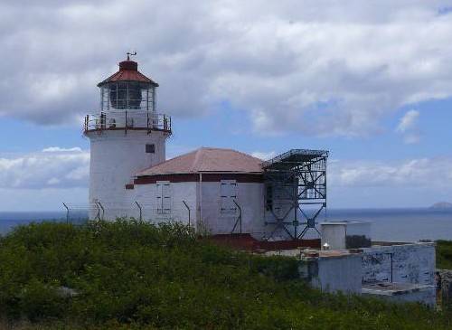
1855. Active; focal plane 111 m (364 ft); four white flashes every 30 s. 16 m (52 ft) cylindrical masonry tower with lantern and gallery, attached to a 1-story keeper's house. Building painted white; lantern roof and gallery rail painted red. The keeper's house was in ruins by the 1950s. Andreas Schuldt's photo is at right and Google has a good satellite view. Île Plate (Flat Island) is more substantial than its name might indicate: it is a high, rather flat-topped rocky island about 15 km (9 mi) off the northern tip of Mauritius. Tours to the island are available and some of them include a visit to the light station. The 20° Sud Hotel operates a restaurant on the island and must have had a hand in a recent restoration of the lighthouse. Located on the southeast side of the island; accessible by boat and a foot trail. Site open, tower closed. Site manager: 20° Sud Hotel. ARLHS MAT-001; Admiralty D7102; NGA 32848.
 
Île Plate Light
Île Plate (Flat Island) Light, September 2009
contributed photo copyright Dr. Andreas Schuldt; used by permission
 
Île aux Fouquets (Île du Phare, Grand Port, Mahébourg)
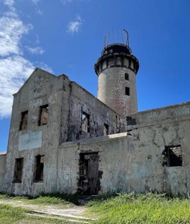
1865. Inactive for many years. 26 m (85 ft) masonry tower with lantern and gallery, attached to a 2-story and 1-story keeper's complex. A 2023 photo is at right, Bertalan Voros contributed a 2007photo, an August 2007 photo and another photo are available, Lightphotos.net has a photo, Guyomard and Carceller have an aerial photo by Jean-Michel Penin, Wikimedia has a distant view, Huelse has a historic postcard view, and Google has a satellite view. This lighthouse guided ships to the harbor of Mahébourg on the southeast coast of Mauritius. Mahébourg was the original French settlement and remained an important port until the early 20th century, when the British moved all port operations to Port Louis on the opposite side of the island. Endangered: the light station has been abandoned for many years and has fallen into ruin, with all the buildings unroofed. Located on a small island about 5 km (3 mi) southeast of Point du Diable and 15 km (10 mi) east of Mahébourg. Accessible only by boat; there is a distant view from the mainland. Site and tower closed. Site manager: Islets National Park. ARLHS MAT-002.

Saint Brandon (Cargados Carajos) Lighthouse
Saint Brandon, also called the Cargados Carajos Shoals, is a coral reef about 430 km (270 ft) northeast of Mauritius. The reef is more than 50 km (30 mi) long and includes several islets, Île Raphael being one of the most substantial. There is no permanent population but varying numbers of fishermen are typically present.

Île Raphael
Date unknown. Active (?); dropped from the Admiralty list but formerly listed with focal plane 17 m (56 ft); continuous white light. 16 m (52 ft) square skeletal tower, painted red with one white horizontal band. A distant view from the sea (fourth photo on the page) and a second distant view (second photo on the page) are available, Wikimedia has an aerial view of the island (click on the photo and zoom in to see the tower), there's a YouTube video taken at the top of the tower, and Google has an indistinct satellite view. Located on Île Raphael near the northern end of the reef. Site open, tower closed. ex-Admiralty D6881.

Île aux Fouquets Light, Mahébourg, April 2023
Google Maps photo by LMO 4350

Rodrigues Lighthouses
Rodrigues is a volcanic island, about 18 km (11 mi) long and 6.5 km (4.0 mi) wide, located about 560 km (350 mi) east of Mauritius. The island has a population of about 40,000. It is quite remote but tourist facilities have been developed in recent years.

*
Port Mathurin Directional (Range Front)
Date unknown. Active; focal plane 8 m (26 ft); continuous white, red or green light, depending on direction. 7.5 m (25 ft) tapered square skeletal tower painted white and carrying a white triangular daymark, point up. Aamir Khan has a distant view (white tower right of center) and Google has a satellite view. The front range light was converted to a directional light in 2017. Located on the waterfront of Port Mathurin. Site open, tower closed. Admiralty D7114; NGA 33028.
Port Mathurin Range Rear (?)
Date unknown. Inactive since 2017. 7.5 m (25 ft) square skeletal tower carrying a white triangular daymark, point up. No photo available but Google has an indistinct satellite view. This light may have been removed. Located on a hillside 420 m (1/4 mi) south southeast of the front light. Site status unknown. ex-Admiralty D7114.1; NGA 33032.

Information available on lost lighthouses:

Notable faux lighthouses:

Adjoining pages: North: Seychelles | West: Réunion

Return to the Lighthouse Directory index | Ratings key

Posted November 15, 2005. Checked and revised April 8, 2024. Lighthouses: 11. Site copyright 2024 Russ Rowlett and the University of North Carolina at Chapel Hill.