Lighthouses of France: Mayotte

Mayotte (also called Maore or Mahoré) is the easternmost of the Comoro Islands, a group of islands in the Mozambique Channel midway between northern Madagascar and the African continent. France gained control over the island in 1843 and incorporated it into its Comoros colony. Independence for Comoros was planned for 1978 but in 1975 the Comorian parliament declared independence unilaterally. Deputies from Mayotte abstained, however, and in 1976 the people of Mayotte voted to continue their link to France. France then vetoed a UN Security Council resolution that would have confirmed Comorian sovereignty over Mayotte.

On 31 March 2011 Mayotte became an overseas département of the French Republic. This gives Mayotte nearly the same status as the mainland departments, so it is part of the European Union and the eurozone.

Dzaoudzi, on the northeast coast, is the capital of the territory. Aids to navigation are probably the responsibility of the department's commercial port of Longoni, operated as the Mozambique Channel Gateway.

French is the official language in Mayotte and is widely spoken as a first or second language. The French word for a lighthouse, phare, is often reserved for the larger coastal lighthouses; a smaller light or harbor light is called a feu (literally "fire," but here meaning "light") or a balise (beacon). The front light of a range (alignement) is the feu antérieur and the rear light is the feu postérieur. In French île is an island, cap is a cape, pointe is a promontory or point of land, roche is a rock, récife is a reef, baie is a bay, estuaire is an estuary or inlet, détroit is a strait, rivière is a river, and havre is a harbor.

ARLHS numbers are from the ARLHS World List of Lights. Admiralty numbers are from volume D of the Admiralty List of Lights & Fog Signals. U.S. NGA List numbers are from Publication 112.

General Sources
Online List of Lights - Îles Comores
Photos by various photographers posted by Alexander Trabas; the Mayotte photos are by Douglas Cameron.
World of Lighthouses - Mayotte
Photos by various photographers avalable from Lightphotos.net.
Navionics Charts
Navigational chart for Mayotte.

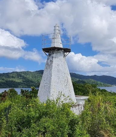
Île Mtsongoma Feu Antérieur, June 2022
Google Maps photo by Dominique Agnès
Northeast Lagoon Lighthouses
Cap Douamougno (Handréma)
Date unknown. Active; focal plane 81 m (266 ft); white, red or green light depending on direction, 2 s on, 2 s off. 7 m (23 ft) white concrete tower. Trabas has Cameron's very distant view fom the sea and Google has a satellite view. This leading light guides vessels through a pass in the reef surrounding the island. Located atop the narrow ridge of the Handréma Peninsula at the northern tip of Mayotte. May be accessible only boat, as there do not appear to be any roads to this location. Site status unknown. Admiralty D6891; NGA 32777.
Récif Vaucluse
Date unknown. Active; focal plane 9 m (30 ft); four green flashes every 15 s. 9 m (30 ft) white concrete tower. No photo available but Google has a distant satellite view. Located on the east end of a reef east of the northern tip of Mayotte. Accessible only by boat. Site status unknown. Admiralty D6892.5; NGA 32777.4.
Île Mtsongoma (M'Songoma) Feu Antérieur
Date unknown. Active; focal plane unknown; very quick flashing light, white, red or green depending on direction. Approx. 12 m (39 ft) hexagonal white concrete tower. A 2022 photo by Dominique Agnès is at the top of this page, Trabas has Douglas Cameron's photo, Charlotte Essertel has a 2017 closeup photo, and Google has a satellite view. The range guides vessels into the lagoon on the northeast side of the island. Located on Île M'Songoma, a small island about 5 km (3 mi) north of Dzoumonyé. Accessible only by boat. Site status unknown. Admiralty D6892; NGA 32777.2.
Île Mtsongoma (M'Songoma) Feu Postérieur
Date unknown. Active; focal plane unknown; very quick flashing light, white, red or green depending on direction. WApprox. 12 m (39 ft) hexagonal white concrete tower. No photo available but Google has a satellite view. Located on the Pointe de Bandraboua, a promontory of the mainland of Mayotte about 1.3 km (0.8 mi) south of the front light. Accessible only by boat. Site status unknown. Admiralty D6892.1; NGA 32777.21.
Isle Blanche (Longoni Range Front)
Date unknown. Active; focal plane about 15 m (49 ft); very quick flashing white light. Approx. 8 m (26 ft) white tower with gallery. A 2009 photo is at right, Trabas has Cameron's view from the sea, and Google has a satellite view. This is an approach range guiding vessels across the lagoon to the new port of Longoni. Located on a small island off the north coast of Mayotte, about 1 km (0.6 mi) northeast of Longoni and about 7 km (4.5 mi) northwest of Koungou. Accessible only by boat. Site status unknown. Admiralty D6894; NGA 32777.5.
Kangani (Longoni Range Rear)
Date unknown. Active; focal plane unknown; very quick flashing white light. Approx. 8 m (26 ft) white tower. Mouhamadi Madjioini has a very distant view and Google has a satellite view. Located on a ridge east of the village of Kangani. Site status unknown. Admiralty D6894.05; NGA 32777.51.
Pamanzi Range Front
Date unknown. Active; focal plane 11 m (36 ft); very quick-flashing white light. 11 m (36 ft) square pyramidal concrete tower. Trabas has Cameron's photo, and Google has a satellite view. The range guides vessels approaching Pamanzi, an island at the southeast end of the lagoon on the northeast coast of Mayotte. Located at the water's edge on the northwest side of Pamanzi. Site status unknown. Admiralty D6894.6; NGA 32766.
* Pamanzi Range Rear
Date unknown. Active; focal plane 50 m (164 ft); very quick flashing white light. Approx. 10 m (33 ft) square white concrete tower. No photo available but Google has a satellite view. Located in a traffic roundabout at the end of the Rue de la CETAM in Dzaoudzi, the principal town of Pamanzi and former capital of Mayotte. Site open, tower closed. Admiralty D6894.61; NGA 32766.1.
Longoni Light
Longoni (Isle Blanche) Light, April 2009
ex-Panoramio Creative Commons photo by franek2

Southeast Lagoon (Passage Bandrélé) Lighthouses
Récif Hajangoua
Date unknown. Active; focal plane 8 m (26 ft); very quick flashing green light. 6 m (20 ft) concrete tower painted green and mounted on a square platform. No photo available but Bing has a distant satellite view. Located on a reef on the north side of the Passage Bandrélé, an opening in the coral reefs off the east coast of Mayotte. Accessible only by boat. Site open, tower closed. Admiralty D6900.5.
* Passage Bandrélé (Bandélé) Feu Antérieur
Date unknown. Active; focal plane 21 m (69 ft); quick-flashing red light, intensified on the range line. 8 m (26 ft) octagonal tower; the light is shown through a square window. Tower painted white with a black horizontal band at the base. Samy Bengeloune has the 2020 photo seen at right and Google has an indistinct satellite view. The range guides vessels through the Passage Bandrélé. Located on the coast about 12 km (7.5 mi) south of Mamoutzou. Site open, tower closed. ARLHS MAY-001; Admiralty D6900; NGA 32768.
* Passage Bandrélé (Bandélé) Feu Postérieur
Date unknown. Active; focal plane 54 m (177 ft); quick-flashing red light, intensified on the range line. 8 m (26 ft) octagonal tower; the light is shown through a square window. Tower painted white with a red horizontal band. 1-story keeper's house nearby. Google has an indistinct satellite view. Located in Bandrélé, 275 m (900 ft) west northwest of the front light and just off national route 3. Site open, tower closed. ARLHS MAY-002; Admiralty D6900.1; NGA 32772.

Information available on lost lighthouses:

Notable faux lighthouses:


Passage Bandrélé Feu Antérieur, November 2019
Google Maps photo by Samy Bengeloune

Adjoining pages: East: Northern Madagascar | West: Comoros

Return to the Lighthouse Directory index | Ratings key

Posted October 30, 2005. Checked and revised January 16, 2024. Lighthouses: 11. Site copyright 2024 Russ Rowlett and the University of North Carolina at Chapel Hill.