Lighthouses of the Union of the Comoros

The Comoro Islands are a group of islands in the Mozambique Channel midway between Madagascar and the African continent. The four major islands are Njazidja (Grande Comore), Mwali (Mohéli), Nzwani (Anjouan), and Mahoré (Mayotte). France acquired control over the islands one by one over a long period between 1841 and 1909, and the islands became a French colony officially in 1912. Independence was planned for 1978 but in 1975 the Comorian parliament declared independence unilaterally. Deputies from Mayotte abstained, however, and Mayotte has remained part of the French community, since 2011 as an overseas department. The other three islands comprise the Union of the Comoros (Umoja wa Komori in Comorian).

The spoken languages in the country, known as Comorian, are derived from Swahili. Arabic is taught in religious schools and French in some non-religious schools; French is the official language of government.

The country has three ports: Moroni on Grande Comore, Fomboni on Mohéli, and Mutsamudu on Anjouan. It appears that each port has its own port authority, which is presumably responsible for navigational aids on its island. Currently two lights on Nzwani (Anjouan) are the only Admiralty listings for this country.

ARLHS numbers are from the ARLHS World List of Lights. Admiralty numbers are from volume D of the Admiralty List of Lights & Fog Signals. U.S. NGA List numbers are from Publication 112.

General Sources
World of Lighthouses - Comoros
Photos by various photographers available from Lightphotos.net.
Online List of Lights - Îles Comores
Photos by various photographers posted by Alexander Trabas.
Navionics Charts
Navigational chart for the Comoros.


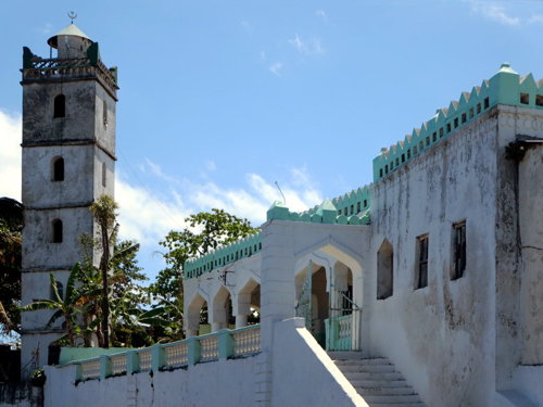
Moroni Light, Grande Comore, October 2013
ex-Panoramio Creative Commons photo by David Stanley

Njazidja (Grande Comore) Lighthouses
* Suadzu Islet Range Front
Date unknown. Inactive since 2013. 6 m (20 ft) square cylindrical white concrete tower. The light is barely visible in a distant view (on the closer point just to the right of the corner of the apartment building) and Bing has a satellite view. Located on an islet, now joined to the mainland by a breakwater, on the waterfront in Moroni. Site open, tower closed. ex-Admiralty D6904; ex-NGA 32744.
* Moroni (with Suadzu Islet Range Rear?)
1904. Inactive at least since 2016 but listed by NGA with a quick-flashing red light for the range and a quick-flashing white light for general navigation. 22 m (75 ft) square cylindrical masonry minaret with a lantern at the top. Entire building painted white. David Stanley's photo is above, Lightphotos.net has a photo, a 2010 photo, and a 2007 closeup photo and a 2004 view are available, but the tower is hard to locate in Google's satellite view. A 1998 view from the sea (no longer online) showed the tower with its red light. Located on the waterfront in Moroni, the national capital and principal town of Njazidja (Grande Comore). Site open, tower closed. General light: ARLHS COM-002; ex-Admiralty D6902; NGA 32752. Range Rear Light: ARLHS COM-003; ex-Admiralty D6904.1; NGA 32748.

Nzwani (Anjouan) Lighthouse
* Vigie (?)
1903. Active (?); listed with focal plane 84 m (276 ft); quick-flashing white light. This was a 5 m (17 ft) square cylindrical concrete (?) tower, painted with black and white horizontal bands. No lantern; the light was shown through a rectangular opening. Google's satellite view of the listed location shows a developed port area with no sign of a small lighthouse. Originally this was the rear light of a range. Located east of the waterfront of Mutsamudu, on the northwest coast of Nzwani (Anjouan). Site open, tower closed. ARLHS COM-004; Admiralty D6882.1; NGA 32732.
Vigie Jetty (1 and 2?)
Date unknown. Active; focal plane 13 m (43 ft); red light occulting twice every 5 s. NGA describe this as a "hut, red lantern." An August 2018 drone view by Kamal Ali shows a square tower with a short mast, but the light has been moved apparently to a taller post painted with red and white horizontal bands. A similar post light is seen farther down the jetty. Google has a satellite view. Ali also has a distant view from the sea taken in 2015. Located at the end of the main pier at Vigie. Site and tower closed. Admiralty D6883; NGA 32736.

Information available on lost lighthouses:

Adjoining pages: East: Mayotte | West: Northern Mozambique

Return to the Lighthouse Directory index | Ratings key

Posted October 30, 2005. Checked and revised January 16, 2024. Lighthouses: 4. Site copyright 2024 Russ Rowlett and the University of North Carolina at Chapel Hill.