Lighthouses of Canada: Southern New Brunswick

The nation of Canada was created by the British North America Act in 1867 with New Brunswick as one of the four original provinces. The area had been part of New France, the French empire in North America, which fell to Britain during the Seven Years War (1756-63). After the war New Brunswick was part of Nova Scotia until separated from that colony in 1784.

The province of New Brunswick has two coastlines. The northern coast faces northeast on the Gulf of St. Lawrence and Northumberland Strait , while the southern coast faces southeast on the Bay of Fundy. The two coasts are separated by a narrow isthmus that joins New Brunswick to Nova Scotia. In addition to its coastal lighthouses the province has lighthouses along the long estuary of the Saint John River, which empties into the Bay of Fundy. This page lists lighthouses of the southern coast and Saint John River; the northern coast is covered on a separate page.

New Brunswick once had well over 100 lighthouses but modern deactivations have left it with fewer than 50 working towers. A number of the decommissioned lights survive, some of them relocated to new homes. One, the Woody Point Light, was relocated to Nova Scotia. Sadly, the province's lighthouse preservation society has disbanded. Local preservation efforts are strong in many communities but there are a number of lighthouses much in need of restoration.

New Brunswick is divided into 15 counties. Although county goverments were abolished in 1966 the counties continue to define regional communities. Outside of the municipalities a large number of local service districts provide public services.

New Brunswick is officially bilingual and about one third of its residents are French speakers. French is spoken commonly in the north of the province and English is more common in the south.

Aids to navigation in Canada are maintained by the Canadian Coast Guard. In 2008 Parliament passed the Heritage Lighthouse Protection Act to designate and protect historic lighthouses.

ARLHS numbers are from the ARLHS World List of Lights. CCG numbers are from the Atlantic Coast volume of the List of Lights, Buoys, and Fog Signals of Fisheries and Oceans Canada. Admiralty numbers are from Volume H of the Admiralty List of Lights & Fog Signals. U.S. NGA numbers are from Publication 110.

General Sources
New Brunswick Canada Lighthouses
Excellent photos with historical and visitor information, from Kraig Anderson's LighthouseFriends.com web site.
Neal's Lighthouse Blog: New Brunswick
Photos and accounts of visits by Neal Doan.
New Brunswick, Canada Lighthouses
Aerial photos posted by Marinas.com.
Lighthouses of the St. John River
History and photos by Kelly Anne Loughery, published by Lighthouse Digest in January 2003.
New Brunswick
Nineteen 2008 photos by C.W. Bash.
Lighthouses in New Brunswick
Photos by various photographers available from Wikimedia.
World of Lighthouses - Atlantic Coast of Canada
Photos by various photographers available from Lightphotos.net.
Online List of Lights - Canada
Photos by various photographers posted by Alexander Trabas. Many of the photos from this area are by Michael Boucher or Capt. Peter Mosselberger ("Capt. Peter").
Leuchttürme Kanadas auf historischen Postkarten
Historic postcard views posted by Klaus Huelse.
List of Lights, Buoys and Fog Signals
Official Canadian light lists.
GPSNauticalCharts
Navigational chart for New Brunswick.
Navionics Charts
Navigational chart for New Brunswick.
NOAA Nautical Chart Locator
U.S. nautical charts for waters close to the U.S. border.
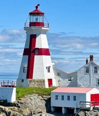

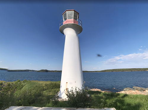
Head Harbour Light, Campobello Island, August 2023
Google Maps photo by Michael David


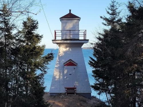
PendleburyLight, St. Andrews, August 2021
Wikimedia Creative Commons photo by Gordon Leggett
Albert County (Chignecto Bay) Lighthouses

Chignecto Bay in an inlet at the northern end of the Bay of Fundy; the inlet separates New Brunswick on west from Nova Scotia on the east. Navigation in the bay in modern times is mostly limited to recreational small craft and a few fishermen.
Pecks Point (relocated to Rockport)
1890 (relocated to Pecks Point in 1908). Inactive since the 1970s. 6.5 m (22 ft) square pyramidal wood tower with lantern but no gallery, painted white with red trim; lantern roof is red. The tower is now covered with vinyl siding. Kelly Anne Loughery has contributed a historic and a modern photo and Google has a street view and a satellite view. This lighthouse was originally built at Wards Point and was relocated to Pecks Point in 1908. After deactivation the station was sold to members of the Tower family. Both the lighthouse and the keeper's house were relocated near Rockport. Located off Lower Rockport Road south of Upper Rockport. Site and tower closed. Owner/site manager: private. ARLHS CAN-731.
Grindstone Island (3)
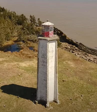
1911 (station established 1859). Inactive 1984-1986 and since 2001. 20.5 m (68 ft) hexagonal concrete tower with six buttresses, lantern and gallery. The original lantern and 4th order Fresnel lens were removed in 1984 and are now in use at the Saint John Harbour lighthouse replica (see below). A 2023 drone view by Eric Goggin is at right, Q.K. Lawson has a 2017 view from the sea, and Google has an aerial photo and a satellite view. The original lighthouse was replaced in 1908 by an octagonal wood tower, but just three years later that lighthouse was largely destroyed by a fire. The third and present lighthouse has a design unique in Atlantic Canada. In 1984 it was deactivated and its lantern and Fresnel lens were removed. At the request of local fishermen the light was reactivated in 1986, and in 1992 the lantern from the Pease Island light in southern Nova Scotia was installed. Endangered. The future of this abandoned light station is unclear, and the lighthouse is deteriorating quickly without maintenance. Most of the island is owned by the Anglican Church of Canada and managed by the Nature Trust of New Brunswick; access requires written permission from the Trust and is never allowed during bird nesting season. Located on an island in Chignecto Bay; visible from nature trails at Mary's Point Bird Sanctuary, at the end of Mary's Point Road off NB 915 at Riverside-Albert. Accessible only by boat. Site and tower closed. Owner: Canadian Coast Guard. Site manager: Nature Trust of New Brunswick (Grindstone Island Preserve). ARLHS CAN-711; ex-Admiralty H4046.
* Anderson Hollow (3) (relocated to Harvey Bank)
1907 (station established 1889). Inactive since the 1950s. Approx. 9 m (30 ft) square pyramidal wood tower, painted white with red trim. No lantern; the light was shone through a square window. It's interesting that this lighthouse has a fake gallery: a non-functional platform was added so that the building presents the traditional pepperpot shape. Santo Perri has a 2015 photo, Damien Balespouey has a 2021 closeup, Dawson Arney has a street view, and Google has a satellite view. Originally located on the wharf at Waterside, this lighthouse has been relocated several times. Presently it is on display at the Shepody River Dam. Located on Mary's Point Road off NB 915 at Riverside-Albert. Site open, tower closed. Owner: Albert County Heritage Trust. Site manager: Harvey Bank Interpretive Centre. . ARLHS CAN-704.


Grindstone Island Light, 2023
Frame from YouTube video by Eric Goggin

Saint John County Lighthouses

Upper Bay of Fundy Lighthouses
**** Cape Enragé (2)
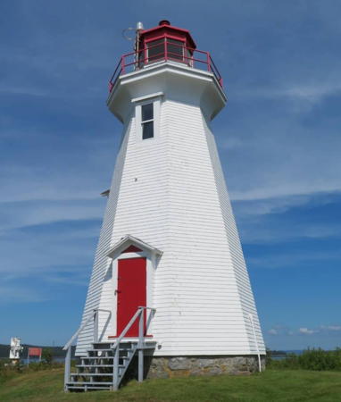
1870 (station established 1838). Active; focal plane 38 m (125 ft); green flash every 6 s. 9 m (29 ft) square pyramidal wood tower with lantern and gallery, painted white with red trim; lantern is red. Fog horn (three 2 s blasts every 60 s). 2-story wood keeper's house restored, beginning in 1993, by students from Harrison Trimble High School in Moncton. Terry Gibson's 2023 photo is at the bottom of this page, Wikimedia has several photos, Trabas has Rainer Arndt's photo, Alain Quevillon has a 2023 photo, Marc Crandall has a street view, and Google has a satellite view. The light station now houses the Cape Enragé Adventure Centre, which offers a variety of activities. There is an interpretive center and tea room in the keeper's house, also a gift shop. A popular tourist stop, Cape Enragé is one of Canada's most successful lighthouse restoration projects. Jeremy D'Entremont wrote a feature article on this light station for the Lighthouse Digest of January 2001. This is now the northernmost active light on the Bay of Fundy's west coast. The shingles on the tower were replaced in 2020 and the tower was repainted in 2021. Located on Barn Marsh Island, which is connected to the mainland by a causeway, south of Alma off NB 915. Parking provided. Site open, tower open to guided tours mid May through mid October. Owner: Canadian Coast Guard. Site manager: Cape Enragé Adventure Centre . ARLHS CAN-096; CCG A-157; Admiralty H4060; NGA 11064.
*** St. Martins (replica with Quaco Head (2) lantern)
1983. Inactive. 8 m (26 ft) square pyramidal wood tower with lantern and gallery, painted white with red trim; lantern is red. A 2021 photo is available, Doan has a page for the lighthouse, Craig Stephen has a photo, and Google has a good street view and a satellite view. This faux lighthouse was built to display the lantern of the 1883 Quaco Head Light. It is smaller than the original lighthouse, which was a square tower attached to a keeper's house. The building serves during the summer as the tourist information center for the St. Martins area. Located at 424 Main Street in downtown St. Martins. Site open, tower open for climbing whenever the information center is open. Owner/site manager: Village of St. Martins.
* Quaco Head (3)
1976(?) (station established 1835). Active; focal plane 26 m (85 ft); white flash every 10 s. 12 m (39 ft) square cylindrical concrete tower with lantern and gallery formerly attached to one corner of a 1-story concrete fog signal building. Fog horn (3 s blast every 30 s). Lighthouse painted white, lantern and gallery red. The lantern room of the second lighthouse (1883) is preserved atop the faux lighthouse and visitor center at St. Martins, and the Fresnel lens is displayed at the Quaco Museum, also in St. Martins. A photo is at right, Tamara Langstroth has a 2020 photo, Christian Hapgood has a 2008 closeup, Trabas has Jim Smith's photo, and Google has a street view and a distant satellite view. Huelse has a historic postcard view of the 1883 lighthouse. Recently the Coast Guard demolished the fog signal building leaving the tower standing alone; Mohammad Niazi has a 2018 photo of the lonely tower. Later the tower was covered with composite aluminum panels and the lantern was repainted. Located at the end of West Quaco Road, off NB 111 near St. Martins. Parking available. Owner/site manager: Canadian Coast Guard. . ARLHS CAN-421; CCG A-150; Admiralty H4076; NGA 11080.

Quaco Head Light, St. Martins, JJuly 2022
Instagram photo by permission

Saint John Harbour Lighthouses
With a fine harbor and ready access from the Atlantic, Saint John is Canada's third largest port. The city has a metropolitan population of about 130,000.
* Cape Spencer (Red Head) (4)
1983 (station established 1873). Active; focal plane 62 m (204 ft); white flash every 11 s. Approx. 12 m (40 ft) fiberglass tower with lantern and gallery. Upper half of the lighthouse painted red, lower half white. Fog horn (three 2 s blasts every 60 s) mounted on an approx. 5 m (17 ft) skeletal tower. Two keeper's houses are now used as private residences. A 2023 photo is at right, Poonam Katewa has a 2021 photo, Pat Shaskin has a photo, a good 2008 photo is available, and Google has a street view and a satellite view. The original lighthouse, a square wood tower attached to a keeper's house, was replaced by an octagonal concrete tower in 1918. A skeletal tower carried the light from 1971 to 1983. Located on a prominent cape at the end of Red Head Road south of East Saint John. Parking available. Owner/site manager: Canadian Coast Guard. . ARLHS CAN-109; CCG A-146; Admiralty H4078; NGA 11088.
Courtenay Bay Breakwater (2)
1946 (?) (station established 1927). Active; focal plane 13.5 m (44 ft); red flash every 4 s. 10 m (33 ft) octagonal concrete tower with lantern; the tower is covered with white aluminum panels. The present tower was built as a faux lighthouse in 1944 as part of an artillery installation placed at the end of the breakwater. The light was added sometime after World War II ended in 1945. In 2018 the Coast Guard upgraded the lighthouse, adding the lantern, the aluminum panels, and a more powerful light. Doan has a page for the lighthouse, Caelan Borowiec has a photo taken before the upgrade, Trabas has Jim Smith's closeup photo, Clay Shannon has a 2021 drone view, and Google has a satellite view. The original light was on a small wood tower. Located at the end of a long breakwater on the east side of Saint John Harbour. Accessible only by boat. Site and tower closed. Owner/site manager: Canadian Coast Guard. ARLHS CAN-906; CCG A-104; Admiralty H4083; NGA 11112.
* Saint John Harbour (Grindstone Island lantern and lens)
1985. Inactive (a decorative red light is displayed). 10 m (33 ft) octagonal wood tower with lantern and gallery, painted white; lantern is red. A closeup 2007 photo is available, Wikimedia also has a photo, Ian Placido has a 2018 photo, Eric Blair has a 2021 photo, and Google has a 2019 street view and a satellite view. This lighthouse was built by personnel of the Saint John Coast Guard Base and equipped with a lantern and 4th order Fresnel lens transferred from the Grindstone Island Light (see above). The lighthouse was not intended as an aid to navigation. The base property was sold for waterfront development in 2008, and the Coast Guard initially stated its intention to move the tower to a new base facility. It seems more likely now that the tower will remain as part of the redevelopment plan. Currently located near the end of the wharf on the former base, on Water Street; visible from across Market Slip. Site and tower closed, but the lighthouse is easy to see from nearby. Owner/site manager: City of Saint John.

Cape Spencer Light, East St. John, June 2023
Instagram photo by Jacqueline Emily
* Saint John Harbour Range Front
Date unknown. Active; focal plane 20 m (66 ft); continuous green light. 18.5 m (60 ft) triangular cylindrical skeletal tower carrying a trapezoidal slatted daymark colored red with a black vertical stripe. Trabas has Boucher's photo and Google has a street view and a satellite view. This is the entrance range for Saint John's inner harbor. Located on the Long Wharf opposite downtown Saint John. Site open, tower closed. Owner/site manager: Canadian Coast Guard. CCG A-100.5; Admiralty H4089; NGA 11104.
* Saint John Harbour Range Rear
Date unknown. Active; focal plane 34 m (111 ft); continuous green light. 11 m (36 ft) triangular cylindrical skeletal tower carrying a trapezoidal slatted daymark colored red with a black vertical stripe. Trabas has Boucher's photo and Google has a street view and a satellite view. Located on the north side of Main Street below Fort Howe, 431 m (1/4 mi) northwest of the front light. Site open, tower closed. Owner/site manager: Canadian Coast Guard. CCG A-100.6; Admiralty H4089.1; NGA 11108.
Partridge Island (4)
1961 (station established 1791). Active; focal plane 35 m (116 ft); white flash every 7.5 s. 14 m (45 ft) octagonal concrete tower with lantern and gallery, vertical sections painted alternately red and white; lantern is red. Robert Foulis has a closeup photo, Trabas has a photo by Capt. Theo Hinrichs, another photo taken from a distance is available, Patrick Flowers has a street view, and Google has a satellite view. The lighthouse is a communications relay station; it also carries a microwave antenna and a radar antenna. Nearby are foundations of the keeper's house, burned by arsonists in 1999. This is New Brunswick's oldest light station. The original lighthouse burned in 1832. The light station was the site of the world's first steam-powered fog horn in 1859; Lighthouse Digest has a March 2005 article on that invention. The second lighthouse was replaced in 1880; the third was demolished in 1959. Partridge Island is a historic site; for many years it was an entry point to Canada for immigrants. Public access to the island was closed in the late 1990s due to increasing vandalism but there have been some recent efforts to reopen it and develop it as a tourist attraction. Located on an island in Saint John Harbour. Visible from many places around the harbor. Site and tower closed; Coast Guard permission is needed to land on the island. Owner/site manager: Canadian Coast Guard. ARLHS CAN-365; CCG A-100; Admiralty H4082; NGA 11100.

Western Saint John County Lighthouses
* Musquash Head (2)
1959 (station established 1879). Active; focal plane 35 m (115 ft); white flash every 3 s. 14 m (46 ft) octagonal concrete tower with lantern and gallery, painted white with a single red horizontal band; lantern is also red. Fog horn (4 s blast every 60 s). A 2023 photo is at right, Doan has a page for the lighthouse, a 2021 photo is available, Lighthouse Digest has Michel Forand's photo, Justin Howe has a closeup, a wider view is available, Patrick Flowers has a 2016 street view, and Google has a satellite view. A hiking trail built in the 1990s provides public access to this isolated station; the surrounding land is part of a Nature Conservancy preserve. In July 2008 ownership of the lighthouse was transferred to a preservation group, Musquash Head Lightstation Inc., but this group disbanded after its president moved away. In late 2018 a new group was considering steps to restore the aging lighthouse; according to the Coast Guard it is basically sound but in need of repairs. The new group is a partnership between the Nature Conservancy and Explore Lorneville. In 2020 fundraising was underway and the lighthouse was repainted. Clay Shannon has a February 2021 photo of the freshly painted lighthouse, and the tower looks great in a July 2021 photo. The original lighthouse was a wood tower rising from a keeper's house. Located at the end of a dirt road off King William Road at the eastern entrance to Musquash Harbour near Lorneville; accessible by a hike of about 1.5 km (1 mi) round trip. Parking available. Site open, tower closed. Operator: Candian Coast Guard. Owner/site manager: Nature Conservancy of Canada (Split Rock Trail/Musquash Head Lighthouse ). ARLHS CAN-332; CCG A-097; Admiralty H4096; NGA 11148.

Musquash Head Light, Lorneville, February 2023
Instagram photo by Maureen Elizabeth
[Chance Harbour (2?)]
1969 (?) (station established 1915). Active; focal plane 12.5 m (41 ft); white flash every 12 s. 7.5 m (25 ft) round fiberglass post colored red with a white horizontal band. Geocaching.com has a photo and Google has a satellite view. Geocaching also has a historic photo of the original lighthouse, a square pepperpot wood tower. Located on a promontory at the entrance to Belding's Cove and Chance Harbour. The surrounding area is a nature preserve, and the lighthouse is accessible by a hiking trail. Site open, tower closed. Owner: Canadian Coast Guard. Site manager: Nature Trust of New Brunswick (Belding's Reef Preserve). ARLHS CAN-125; CCG A-093; Admiralty H4100; NGA 11152.

Charlotte County (Southern Coast) Lighthouses

South Coast and Passamaquoddy Bay Lighthouses
Point Lepreau (3)
1959 (station established 1831). Active; focal plane 25.5 m (84 ft); white flash every 3 s. 17.5 m (58 ft) octagonal concrete tower with lantern and gallery, painted with red and white horizontal bands; lantern is red. Fog horn (three 2 s blasts every 60 s). A closeup is available and Google has a satellite view. The lighthouse marks one of the most prominent points on the Bay of Fundy coastline. The original lighthouse burned in January 1898, and its replacement, an octagonal wood tower, also burned after being struck by lightning in December 1956. Located on the grounds of the Point Lepreau Nuclear Generating Station. Site and tower closed. Owner: Canadian Coast Guard. Site manager: New Brunswick Power. ARLHS CAN-390; CCG A-090; Admiralty H4108; NGA 11160.
* Lighthouse Point (Drews Head, Beaver Harbour) (3)
1984 (station established 1875). Active; focal plane 14.5 m (47 ft); white light, 7 s on, 8 s off. 8 m (28 ft) fiberglass tower with lantern and gallery, painted white; lantern is red. 1-story fog signal building. Fog horn (6 s blast every 60 s). Sibling of Cape Spencer Light (above). Jonathan Harpur's 2019 street view is at right, Trabas has Boucher's photo, a 2021 photo is available, Bash has a photo, Lighthouse Digest has Michel Forand's photo, Russ Barry has a closeup photo, and Google has a satellite view. The original lighthouse was replaced by a skeletal tower in the late 1960s. Located beyond the end of Lighthouse Road, off Main Street in Beaver Harbour; accessible by a walk of about 800 m (1/2 mi) round trip. Limited parking. Site open, tower closed. Owner/site manager: Canadian Coast Guard. ARLHS CAN-162; CCG A-083; Admiralty H4112; NGA 11184.

Lighthouse Point Light, Beaver Harbour, June 2019
Google Maps street view by Jonathan Harpur
Pea Point (2)
1965 (station established 1878). Active; focal plane 17 m (56 ft); continuous white light. 10 m (34 ft) square cylindrical concrete tower with lantern and gallery, rising from one corner of a 1-story concrete fog signal building. Fog horn (two 3 s blasts every 60 s). Trabas has Boucher's closeup photo (also seen at right), Lighthouse Digest has Michel Forand's photo, Thomas Haines has a 2016 photo, Terry Barrett has a 2018 street view, and Google has a satellite view. A 2023 closeup shows the lighthouse in great need of repainting and repairs. Anderson has a Coast Guard photo of the old and new lighthouses in 1965. The 2-story keeper's house was burned in 1989; a 1-story cottage built in 1965 was relocated to Lancaster. Located on a small island near the Grand Manan Island ferry terminal near Black's Harbour. Although it is possible to walk to the lighthouse at low tide, treacherous footing and rapidly changing tides make this hazardous. Site and tower closed. Owner/site manager: Canadian Coast Guard. . ARLHS CAN-366; CCG A-081; Admiralty H4114; NGA 11192.
Southwest Wolf Island (2)
1982 (station established 1871). Active; focal plane 39 m (128 ft); white flash every 10 s. 8 m (28 ft) fiberglass tower with lantern and gallery, painted white; lantern is red. Trabas has Capt. Peter's photo, Brent Wilson has a view from the sea, Lighthouse Digest has Stan Severi's aerial photo, Marinas.com has aerial photos, and Bing has a satellite view. Anderson has a Coast Guard photo of the original lighthouse. Located on the southern tip of the island in the Wolf Islands off the mouth of Passamaquoddy Bay. Accessible only by boat; visible distantly from the Grand Manan ferry and from Head Harbour Light on Campobello Island (see below). Site open, tower closed. Owner/site manager: Canadian Coast Guard. ARLHS CAN-470; CCG A-036; Admiralty H4110; NGA 11172.

Pea Point Light, Black's Harbour
photo copyright Michael Boucher; used by permission
Bliss Island (2)
1964 (station established 1871). Inactive since 2016. 12 m (38 ft) square cylindrical concrete tower with lantern and gallery, rising from one corner of a 1-story concrete fog signal building. Karl Agre has a 2012 view from the sea, Trabas has Capt. Peter's view from the sea, Marinas.com has aerial photos, and Google has a satellite view. The active light (focal plane 12.5 m (41 ft); red flash every 4 s) is now on a 7.5 m (25 ft) square skeletal tower next to the historic lighthouse. Located on the southwest point of the island in the entrance to Bliss Harbour. Accessible only by boat. Site open, tower closed. Owner/site manager: Canadian Coast Guard. ARLHS CAN-045. Active light: CCG A-077; Admiralty H4118; NGA 11200.
** L'Etete Passage (Green's Point)
1903 (fog signal station established 1879). Inactive since 1999 (fog signal remains active). 12 m (39 ft) octagonal pyramidal wood tower with lantern and gallery, painted white with red trim. Fog signal (3 s blast every 30 s). Nicki Brown's 2020 photo is at right, another 2008 photo and a 2022 photo are available, Marilyn Leland Bennett has a 2017 photo, Kelly Anne Loughery contributed a 2008 photo, Marinas.com has aerial photos, and Google has a street view and a distant satellite view. Trabas has Bash's photo showing the fog signal. The station guards the passage between Deer Island and the mainland. The keeper's house is now a museum displaying items of lighthouse and local maritime history.; a neighboring 1-story Coast Guard monitoring station is privately owned but available for vacation rental. In July 2008 the Coast Guard transferred ownership of the lighthouse to the Green's Point Light Association. Located on the point, a peninsula connected to the mainland by a narrow isthmus near the Deer Island ferry terminal in L'Etete. Site open, museum open daily mid June through early September, tower closed. Owner/site manager: Greens Point Light Association . ARLHS CAN-214. Fog signal: CCG A-071; Admiralty H4120; NGA 11208.
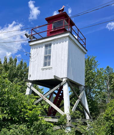
* St. Andrews (Pendlebury, North Point)
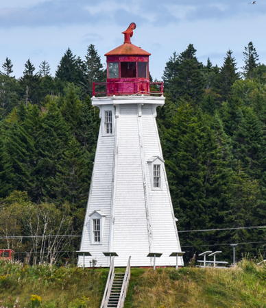
1833. Inactive since 1938; a decorative white light is now displayed. Approx. 9 m (30 ft) octagonal pyramidal wood tower with lantern, painted white; lantern roof is red. Gordon Leggett's 2021 photo is at the top of this page, Tamara LLangstroth has a closeup photo, Andy Adams has a 2022 photo, a 2011 photo is available, and Google has a closeup street view and a satellite view. As of early 2002 this historic and long-abandoned lighthouse was in poor condition, as was the seawall that supported it. The lantern had been removed many years before, and the tower carried a red cap. The lighthouse ranked #1 on the former NBLHS Endangered List. In 2002 the private owner of the lighthouse transferred it to the St. Andrews Civic Trust and in July of that year the Trust relocated the tower about 15 m (50 ft) from the seawall so that it could be restored. The plan was to repair the seawall and the return the restored lighthouse to its original location, possibly to be relit. A 2005 closeup photo did not show any change but a July 2009 photo showed the lighthouse freshly repainted. Jimmy Emerson's July 2010 photo showed work in progress. The restoration was completed with the installation of a replica lantern in October 2011. Huelse has a historic postcard view of the lighthouse and Wikimedia has a historic photo taken in 1895. Trabas has Boucher's photo of the active light (focal plane 7 m (23 ft); red flash every 4 s) on a skeletal tower offshore, about 75 m (250 ft) south of the lighthouse. Located at the end of Patrick Street in St. Andrews, adjacent to a restaurant. Site open, tower closed. Owner: St. Andrews Civic Trust. Site manager: Town of St. Andrews. . ARLHS CAN-714. Active light: CCG A-064; Admiralty H4127; NGA 11230.

Greens Point Light, L'Etete, July 2020
Instagram photo by Nicki Brown
[Tongue Shoal (Sand Reef) (2?)]
Date unknown (station established 1875). Active; focal plane 7 m (23 ft); white flash every 4 s. 7 m (23 ft) square skeletal tower, painted red and carrying three daymarks colored red with a white horizontal band, mounted on a platform supported by piles. Trabas has Capt. Peter's photo and Google has a distant satellite view. Anderson has a 1926 photo of the original lighthouse, which was demolished in the late 1950s. Located on a sandbar shoal about 1.6 km (1 mi) off the St. Andrews waterfront. Accessible only by boat. Site open, tower closed. ARLHS CAN-948; CCG A-067; Admiralty H4126; NGA 11232.

Deer and Campobello Islands Lighthouses
Deer Island and Campobello Island are substantial islands in the mouth of Passamaquoddy Bay close to the U.S. border. Deer Island is about 13 km (8 mi) long and is accessible by ferries from L'Etete and from Eastport, Maine. Another ferry operates between Deer Island and Campobello Island. Campobello is larger, about 16 km (10 mi) long; it is accessible by the ferry from Deer Island and by bridge from Lubec, Maine. The location of the U.S.-Canada border in the bay was in dispute for many years until it was finally settled by the Passamaquoddy Bay Treaty of 1910.

Leonardville
1914. Active; focal plane 20 m (66 ft); continuous white light. 8 m (28 ft) square pyramidal wood tower with lantern and gallery, painted white with red trim. Fritz Garcia has the 2021 photo seen at right, Trabas has Capt. Peter's view from the sea, Lighthouse Digest has Michel Forand's photo, Marinas.com has aerial photos, and Google has a satellite view. Located on a cliff at the entrance to Leonardville Harbour on the east side of Deer Island. Site and tower closed (private property) but the lighthouse can be seen from NB 772 through trees. Owner/site manager: Canadian Coast Guard. ARLHS CAN-274; CCG A-046; Admiralty H4146; NGA 11264.
* [Deer Point]
Date unknown. Active; focal plane 10 m (33 ft); red light, 2 s on, 8 s off. 6 m (20 ft) round white fiberglass tower. Trabas has Capt. Peter's photo, Emma Green has a 2017 photo, Chantal Pierre has a closeup street view, and Google has a satellite view. Accessible by road; parking provided. Visitors come to see a whirlpool that develops during rising tides just offshore from the lighthouse. Located in Deer Island Point Park at the southern tip of Deer Island. Site open, tower closed. ARLHS CAN-157; CCG A-049; Admiralty H4147; NGA 11316.

Leonardville Light, Deer Island, March 2021
Google Maps photo by Fritz Garcia
[Cherry Island (2)]
Date unknown (fog signal station established 1903, light added in 1969). Active; focal plane 10 m (33 ft); white flash every 5 s. 7.5 m (25 ft) round cylindrical tower painted white with a red band at the top. Fog horn (2 s blast every 20 s). Trabas has Capt. Peter's photo, a 2023 view from the sea is available, and Google has a satellite view. In 1969 a light was placed atop the original wood fog signal tower; Anderson has a photo. Located at the south end of a small island between Dear Island and Campobello Island. Accessible only by boat. Site open, tower closed. ARLHS CAN-134; CCG A-041; Admiralty H4152; NGA 11328.
* Head Harbour (East Quoddy Head)
1829. Active; focal plane 17.5 m (58 ft); continuous red light. 15.5 m (51 ft) octagonal pyramidal wood tower with lantern and gallery, connected to a keeper's house by a covered walkway. Fog signal building (1914) and other light station buildings. Fog horn (4 s blast every 60 s). Lighthouse painted white with one red vertical stripe and one red horizontal band forming the pattern of St. George's Cross, the symbol of England. Michael David's 2023 photo appears at the top of this page, the friends group has a huge portfolio of photos on Flickr.com, Trabas has Ronald Wöhrn's photo, Keith Grinstead has a 2019 photo, Pauline Rosenberg has a good 2011 photo, a fine 2008 photo is available, Joey Murawski has a 2016 street view, Marinas.com has aerial photos, Huelse has a historic postcard view, and Google has a distant satellite view. This is New Brunswick's oldest lighthouse, one of Canada's best known and most photographed lighthouses, and one of the few light stations in the province that has all its original structures. The Friends of Head Harbour Lightstation, founded in 2000, are working to improve access and restore the buildings. In 2006 the Friends painted the entire light station. Photos of their current activities are usually available. Located on a rocky islet off the northernmost point of Campobello Island, which is accessible by bridge from Lubec, Maine. Site open; access to the light station is by a narrow sandbar covered by water at high tide, so care is required. Tower closed. Owner/site manager: Friends of Head Harbour Lightstation . ARLHS CAN-166; CCG A-044; Admiralty H4154; NGA 11332.
* Mulholland Point
1885. Inactive since 1963. 13.5 m (44 ft) octagonal pyramidal wood tower with lantern and gallery, painted white; lantern is red. Picnic area adjacent to the tower. Gordon Leggett's 2021 photo is at right, Lighthouse Digest has Jeremy D'Entremont's photo, Bash has a 2008 photo, Jean Warren has a nice 2023 view, Marinas.com has aerial photos, Sarah Breese has a street view, and Google has a satellite view. The lighthouse was deactivated with the completion of the Franklin D. Roosevelt Bridge, which connects the island to Lubec, Maine. It was purchased by Clifford Calder, a local resident. He later sold the lighthouse to members of the Look family, and they donated to the Roosevelt Campobello International Park in 1984 in memory of Calder. Located on the west side of Campobello Island about 400 m (1/4 mi) north of the Franklin D. Roosevelt Bridge, which connects the island to Lubec, Maine. Site open, tower closed. Owner/site manager: Roosevelt Campobello International Park. . ARLHS CAN-326.

Mulholland Point Light, Campobello Island, September 2021
Wikimedia Creative Commons photo by Gordon Leggett
Grand Manan Island Area Lighthouses
Grand Manan Island is larger than either Deer or Campobello. About 30 km (19 mi) long, it lies in the Bay of Fundy about 12 km (7.5 mi) southeast of West Quoddy Head, Maine. The island is accessible year-round by ferry from Blacks Harbour.

*
Long Eddy Point (Whistle)
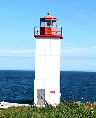
1966 (fog signal station established 1871). Active; focal plane 38.5 m (126 ft); red flash every 8 s. 9.5 m (31 ft) square cylindrical concrete tower with lantern and gallery, rising from one corner of a 1-story concrete fog signal building. Lighthouse painted white with red trim; lantern is red. Fog horn (4 s blast every 60 s). Crystal Reinhard has a 2022 photo, Lighthouse Digest has Michel Forand's photo, Trabas has Boucher's photo, Marinas.com has aerial photos, Patrick Flowers has a street view, and Google has a satellite view of the station. The fog signal station was known for generations as "The Whistle," so the lighthouse is sometimes called the Whistle Light. In February 2017 the lighthouse was recognized as a Heritage Lighthouse and ownership was transferred to the Village of Grand Manan. The Swallowtail Keepers Society has taken over maintenance under a lease from the village. Located at the northern tip of Grand Manan Island. Site open, tower closed. Owner: Village of Grand Manan. Site manager: Swallowtail Keepers Society. . ARLHS CAN-283; CCG A-034; Admiralty H4166; NGA 11360.
*** Swallowtail
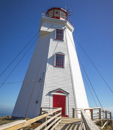
1860. Active; focal plane 37 m (122 ft); white light, 4 s on, 2 s off. 16 m (53 ft) octagonal pyramidal wood tower with lantern and gallery, painted white with red trim; lantern is red. Fog horn (2 s blast every 20 s). The keeper's house, restored by a movie production company in 1996, operated for several years as a bed and breakfast inn, but it is no longer in use. A 2024 photo is at right, Anderson has a fine page for the lighthouse, Trabas has Boucher's photo, Wikimedia has photos, Patrick Flowers has a street view, Marinas.com has aerial photos, Huelse has a historic postcard view, and Google has a satellite view. This historic light, fifth oldest in New Brunswick, has been in need of restoration. In fall 2004 the lighthouse was painted by the Grand Manan Rotary Club and other volunteers. The building looked fine in a photo taken after the painting, but a 2006 photo shows how quickly the paint weathers. The building was painted again in summer 2006. In March 2008 the village of Grand Manan briefly put the keeper's house up for sale, but after public outcry the sale was cancelled and the Swallowtail Keepers Society was organized to work for preservation and operation of the lighthouse. Ownership of the lighthouse was transferred to the Village of Grand Manan in 2012. In 2013 grants from the provincial government helped fund site improvements, including a new boardwalk. Following additional restoration the tower was opened in 2015. The lantern of the former Great Duck Island lighthouse (next entry) was placed on display. In 2022 the Society launched a campaign to raise $300,000 to restore the exterior of the lighthouse. Federal and provincial grants totaling $170,000 covered much of the cost. In early 2023 water damage in the interior heightened concern for the lighthouse. Restoration was underway during the summer, with a Coast Guard helicopter delivering supplies by air. The restoration was completed in November 2023. Vinyl siding was installed, ending the need for frequent repainting. The name "Swallowtail" comes from the lighthouse's location on the more northern of two sharp points. The ferry from Blacks Harbour passes the lighthouse on arriving. Located off Old Airport Road at the end of a rocky peninsula north of North Head; accessible by a short hike that includes a steep stairway and a bridge over a deep gorge. Parking provided. Site open year round, gift shop and tower open daily during the summer season. Owner/site manager: Village of Grand Manan (Swallowtail Lighthouse ). ARLHS CAN-491; CCG A-033; Admiralty H4168; NGA 11364.
#Great Duck Island (1)
1966 (fog signal station established 1886). Inactive since 2015 and probably removed. Approx. 9 m (30 ft) square cylindrical concrete tower; lantern removed. Lighthouse originally painted white. The active light (focal plane 16.5 m (54 ft); white flash every 10 s) on a 9 m (30 ft) square cylindrical skeletal tower carrying a red and white daymark. Fog horn (4 s blast every 60 s). Trabas has Boucher's photo, Marinas.com has aerial photos, and Google has a satellite view. The lantern of the lighthouse is now on display at the Swallowtail lighthouse (previous entry). The tower was formerly at one corner of a 1-story fog signal building. The old tower was still standing forlornly in an August 2017 photo by John Banks but the Coast Guard planned to demolish it as soon as funds and equipment became available. Note: there are also Great Duck Island lighthouses in Ontario and in Maine. Located at the south end of the island off the east coast of Grand Manan Island near Woodward's Cove. Accessible only by boat. Site open, tower closed. Owner/site manager: Canadian Coast Guard. ARLHS CAN-210. Active light: CCG A-029; Admiralty H4174; NGA 11384.

Swallowtail Light, Grand Manan, April 2024
Instagram photo by Maritimes Maven Travel
#Grand Harbour (Ross Island, Fish Fluke Island)
1879. Inactive since 1963. Square pyramidal wood tower attached to 1-1/2 story wood keeper's house. The abandoned lighthouse collapsed in ruins sometime in 2013. Once called "the most endangered lighthouse in North America," it became a lost cause. Hans Raffelt has an August 2006 photo and Marinas.com has aerial photos. A June 2008 photo and Roger Lewis's July 2011 photo show the lighthouse still standing, but barely. It had collapsed by 2013. The Swallowtail Keepers Society posted a photo of the ruins (second photo on the page). Huelse has a historic postcard view and Google has a distant satellite view. Located on Ross Island, accessible from Grand Harbour, Grand Manan Island, at low tide. However, the island is privately owned. Site closed. owner/site manager: private. ARLHS CAN-709.
* Long Point
1966 (fog signal station established 1929). Active; focal plane 15.5 m (51 ft); white light, 6 s on, 6 s off. 11 m (37 ft) square cylindrical concrete tower with lantern and gallery, covered with white siding, formerly rising from one corner of a 1-story fog signal building. Lantern painted red. Fog horn (2 s blast every 20 s). Ahmet Caner Tahan has a 2020 street view and Google has a satellite view. A foggy 2006 photo of the lighthouse with the fog signal building is available and Marinas.com has aerial photos. Located on the southern end of White Head Island southeast of Grand Manan Island; accessible by ferry from Grand Manan. Site open, tower closed. Owner/site manager: Canadian Coast Guard. ARLHS CAN-644; CCG A-025; Admiralty H4178; NGA 11400.
* Southwest Head (2)
1959 (station established 1880). Active; focal plane 48 m (157 ft); white flash every 10 s. 9 m (30 ft) square cylindrical concrete tower with lantern and gallery, formerly attached to a 1-story fog signal building. Lighthouse painted white with red trim; lantern is red. Fog horn (6 s blast every 60 s). A tall communications tower nearby dwarfs the lighthouse. A closeup 2021 photo is available, Danny Boudreau has a 2022 photo, and Google has a satellite view. Trabas has Boucher's photo, taken before the fog signal building was removed, a foggy 2007 closeup is available, Patrick Flowers has a closeup 2016 street view, Kate Wellington has a distant view, and Marinas.com has aerial photos. Located at the end of NB 776 and at the brink of a vertical cliff on the southwestern point of Grand Manan Island. Accessible by road. Site open, tower closed. Owner/site manager: Canadian Coast Guard. . ARLHS CAN-469; CCG A-011; Admiralty H4186; NGA 11436.
Gannet Rock
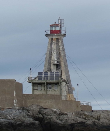
1831 (John Purvis). Inactive, although the tower still carries the station's radar (racon) beacon. 23 m (75 ft) octagonal pyramidal wood tower attached to 2-story stone keeper's house. Lighthouse painted with black and white vertical stripes; lantern is red. The light has been replaced by two lights on posts, one (Gannet Rock North, CCG A-008.1; Admiralty H4186.4) beside the tower and one (Gannet Rock South, CCG A-008.2; Admiralty H4186.5) on the platform behind the keeper's house. Both have white lights (2 s on, 1 s off) and both are seen in Karl Agre's photo at right. The lantern is modern (1967). A 2nd order Fresnel lens and a DCB aerobeacon formerly used in the lighthouse are on display at the Grand Manan Museum in Grand Harbour. Trabas has Boucher's photo of the lighthouse and his photo of the South Light, René Lortie has a good view from the sea, Plinio Lisboa has a 2022 photo, Lighthouse Digest has an account of life on the rock by the daughter of a former keeper, Marinas.com has fine aerial photos, Huelse has a historic postcard view, and Google has an indistinct satellite view of the reef. Gravely endangered. Staffed until 1996, this historic lighthouse deteriorated sadly after it was automated. The Coast Guard carried out a restoration is 2003 but since then the lighthouse has fallen back into very poor condition. Located on a bare, half-acre island about 10 km (6 mi) southeast of Southwest Head. Accessible only by boat in very dangerous seas; landing on the island is difficult. Site and tower closed. Owner/site manager: Canadian Coast Guard. ARLHS CAN-192; CCG A-008 (racon); ex-Admiralty H4188; NGA 11416.
Gannet Rock Light
Gannet Rock Light, Bay of Fundy, September 2012
Flickr photo copyright Dr. Karl Agre; used by permission
Machias Seal Island (3)
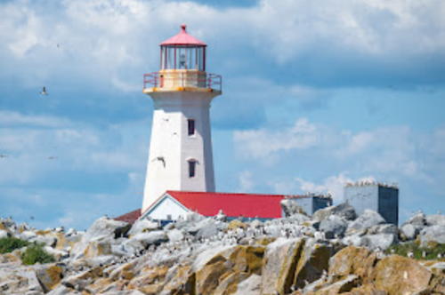
1915 (station established 1832). Active; focal plane 25 m (82 ft); white flash every 3 s. 18 m (60 ft) octagonal concrete tower with lantern and gallery, painted white; lantern is red. Fog horn (two 3 s blasts every 60 s). Two 1-story Coast Guard buildings (1950s) with red roofs. Mike Surette's 2022 photo is at right, Trabas has Boucher's photo, Lighthouse Digest has a good photo by Jeremy D'Entremont, Robert Neal has a 2023 photo, a 2017 photo is available, and Google has a satellite view. Originally twin lighthouse were built on the island. In 1869 one of them was replaced, and in 1878 the other tower was replaced and the two towers were lit as a range. In February 2015 the lighthouse was named a Heritage Lighthouse. Machias Seal Island is a small (7 ha; 15 acre) island about 19 km (12 mi) southwest of Grand Manan Island and 12 km (7.5 mi) southeast of Cutler, Maine. The island is claimed by both Canada and the United States. This dispute is more than 200 years old and is quite amicable on the whole but to assert Canadian sovereignty the Coast Guard staffs this station year round with rotating crews of two keepers serving for four weeks each. (The cost of the staffing is reimbursed by the Canadian Department of Foreign Affairs.) The station and lighthouse are powered by a large array of solar panels. The island is also an important bird nesting area and both countries recognize it as a wildlife preserve. Located on the highest point of the island. Accessible only by boat; ecotours are available from Seal Cove on Grand Manan and from Cutler and Jonesport, Maine. Owner/site manager: Canadian Coast Guard. . ARLHS CAN-292; CCG A-006; Admiralty H4192; NGA 11444.

Machias Seal Island Light, Bay of Fundy, July 2022
Google Maps photo by Mike Surette

Saint John River Lighthouses

 
The Saint John River is navigable for small craft between Saint John and Fredericton, the capital of New Brunswick. The river was formerly marked by a least two dozen small lighthouses. About half of them survive, and only half of those remain active. Most of these lighthouses are poorly known and several are endangered.

Saint John County Lighthouse
Swift Point (Green Head) (2)
2018 (station established 1869). Active; focal plane 28 m (92 ft); green flash every 12 s. 14 m (46 ft) square pyramidal tower with lantern and gallery, colored white with red trim; lantern painted red. Jim Watters's 2018 street view is at right, Jordan McWilliams has a 2018 photo, Janelle Donnahee has a 2021 closeup, and Google has a satellite view. Trabas has Boucher's photo of the original lighthouse and Doan has a page with 2009 photos. The original lighthouse was destroyed by a fire of unknown origin on the evening of 13 June 2017. The new light was in service by February 2018. The lighthouse acts as a leading light marking the western entrance to the Saint John River Gorge; ships bound downstream steer directly towards it to find the proper channel. Located on the west side of the river at the end of a dirt road off Green Head Road on the northwest side of Saint John; the road is gated but the lighthouse is accessible by a walk of about 1.6 km (1 mi). Site open, tower closed. Owner/site manager: Canadian Coast Guard. . ARLHS CAN-492; CCG A-116; Admiralty H4090; NGA 11132.

Kings County Lighthouses
* Renforth (replica)
1980s. Active (privately maintained and unofficial); continuous white light. 6 m (20 ft) octagonal pyramidal wood tower with lantern and gallery, painted white; lantern painted red. Anderson has photos, Rostyslav Kolinko has a 2019 photo, Brian Evans has a 2018 photo, and Google has a street view and a satellite view. The lighthouse was built in a small community park near the Renforth Boat Club. Located off Rothesay Road in Renforth, on the east side of the Kennebecasis River (the eastern branch of the Saint John estuary). Site open, tower closed. Owner/site manager: unknown. .

Swift Point Light, Saint John, September 2018
Google Maps street view by Jim Watters
* McColgan Point
1914. Active; focal plane 12 m (37 ft); white light, 2 s on 10 s off. 8 m (27 ft) square pyramidal wood tower with lantern and gallery, painted white; lantern roof is red. Tamara LLangstroth has a closeup photo, a 2024 photo is available, and Google has a satellite view. Located on the north side of the Milkish Channel, on the Kingston Peninsula, just south of the Kennebecasis Island ferry wharf. Site and tower closed (land access is through private property). Owner/site manager: Canadian Coast Guard. ARLHS CAN-309; CCG A-119; Admiralty H4090.1; NGA 11138.
* Bayswater
1914. Inactive since 2005. 8 m (27 ft) square pyramidal wood tower with lantern and gallery, painted white; lantern roof is red. A closeup photo is available, Neal Doan has a 2012 photo, a 2021 photo is available, and Google has a 2023 street view and a satellite view. A twin of the McColgan Point Light. Since 2012 the lighthouse has been leased to a community group, and it was to be transferred to their ownership. While preparing for this transfer in November 2016 the Coast Guard found the wood in the tower to be rotted beyond repair, with demolition being the only safe option. However, community residents rallied to stop the demolition. In June 2018 the beleaguered lighthouse was granted federal Heritage Lighthouse status. Ownership was transferred to the Bayswater Lighthouse Non Profit Group in 2019 and with the help of an $80,000 federal grant the lighthouse was restored in late summer. Located on the Kingston Peninsula beside NB 845. Site open. Owner/site manager: Bayswater Lighthouse Non Profit Group. ARLHS CAN-025; ex-CCG A-120.
* Sand Point (2)
1898 (station established 1869). Active; focal plane 23 m (75 ft); continuous red light. 17.5 m (58 ft) square pyramidal cast iron skeletal tower with enclosed watch room, lantern and gallery. Skeletal portion painted red, watch room and lantern white, lantern roof red. Like the Swift Point Light (above), this is a leading light; ships bound upstream from Saint John steer directly towards it to find the channel to the upper river. James Mullinger's photo is at right, Lighthouse Digest has Kelly Anne Loughery's photo, Trabas has Boucher's closeup, Jordan Crowe has a wintry photo, John MacKenzie has a 2021 photo, and Google has a satellite view. This lighthouse was renovated in 1991 and the Coast Guard restored it again around 2020. In June 2014 it was recognized as a Heritage Lighthouse. Located at the end of Sand Point Wharf Road, between Bayswater and Carter Point. Site open, tower closed. Owner/site manager: Canadian Coast Guard. ARLHS CAN-445; CCG A-121; Admiralty H4090.3.

Sand Point Light, Westfield, January 2019
Instagram photo by James Mullinger
* Belyeas Point (2)
1930s (station established 1882). Active; focal plane 14 m (45 ft); green flash every 5 s. 11 m (37 ft) square pyramidal wood tower with lantern and gallery, painted white with red trim; lantern painted red. Doan has a page with photos, Trabas has Boucher's closeup, and Google has a street view and a satellite view. The lighthouse was rebuilt and slightly relocated following severe floods in the 1930s. Located on the west side of the river at the lower end of the Long Reach, about 3 km (2 mi) north of Westfield. Accessible by road, parking available, but the entrance from route 102 is unmarked. Site open, tower closed. Owner/site manager: Canadian Coast Guard. ARLHS CAN-031; CCG A-122; Admiralty H4090.5.
The Cedars
1904. Inactive since 1994. 10 m (32 ft) square pyramidal wood tower with lantern and gallery, painted white with red trim; lantern painted red. Doan has a page with photos and Google has an indistinct satellite view. In 2005 the lighthouse was purchased by the Kingston Peninsula Heritage society. In 2008 a walking path was completed, making the lighthouse accessible to the public for the first time. Located on the east side of the Long Reach of the river, off NB 845 in Long Reach, about 10 miles north of the Hardings Point ferry. Accessible by a hiking trail from NB 845 in Long Reach; the trail entrance is well marked. Site open, tower closed. Owner/site manager: Kingston Peninsula Heritage (Cedars Lighthouse). ARLHS CAN-124.
* Oak Point (2)
1902 (station established 1869). Active; focal plane 16 m (52 ft); green light, 2 s on, 8 s off. 14.5 m (48 ft) square pyramidal wood tower with lantern and gallery, mounted on four short concrete pillars. Lighthouse painted white with red trim; lantern painted red. A photo by Corey Ann Balazowich is at right, Travis Mackenzie has a 2021 photo, Doan has a page with photos, Lighthouse Digest has Kelly Anne Loughery's photo, Greg Hickman has a good view from the river, Jonathan Harpur has a closeup 2020 street view, and Google has a satellite view. Formerly modified for use as a gift shop, this lighthouse has been returned to its historic appearance. Oak Point is a park owned by the provincial government but leased to the local Kiwanis Club for management. Located at the tip of Oak Point, on the west side of the Long Reach of the river off NB 102, adjacent to the campground of the park, but perilously close to the river. The entrance from route 102 is unmarked. Site open, tower closed. Owner: Canadian Coast Guard. Site manager: Oak Point Kiwanis Park. ARLHS CAN-358; CCG A-125; Admiralty H4090.7.
 

Oak Point Light
Oak Point Light, Greenwich, October 2012
Flickr Creative Commons photo by Corey Ann Balazowich


Queens County Lighthouses
* Hampstead
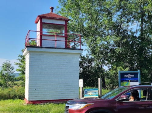
1900. Inactive since 1994. 5.5 m (18 ft) square cylindrical tower with lantern. Dallas Carr's 2021 photo is at right, Doan has a page with photos , Travis Mackenzie has a 2021 closeup photo, Dallas Carr has a photo, and Google has a street view and a satellite view. One of the smallest Canadian lighthouses, this abandoned tower was relocated to higher ground in 1999 near the ferry wharf in Hampstead, on the west side of the river just off NB 102. Previously endangered, since the Saint John River Society assumed management of the wharf but initially declined to take responsibility for the lighthouse. In 2009 the society accepted ownership and a 2010 photo shows the lighthouse restored and in fine condition. Site open, tower closed. Owner/site manager: Saint John River Society. ARLHS CAN-221.
Lower Musquash Island (2)
1893 (station established 1876). Inactive since 1994. 12 m (37 ft) square pyramidal wood tower with lantern, painted white with red trim; lantern painted red. Google has a satellite view. Originally this was the front light of a range with the Hendry Farm Light (next entry) as the rear light. The lighthouse was deactivated in 1922 but then reactivated in 1924. After its final deactivation the lighthouse was given to the owner of the property on which it stands. Located near Lower Cambridge on an island in the entrance to Washademoak Lake, which is not a lake but a northeastward branch of the Saint John estuary. Accessible only by boat or a walk of about 2 km (1.25 mi) round trip. Site open, tower closed. Owner/site manager: private. ARLHS CAN-333.
* Hendry Farm (2)
1893 (station established 1876). Inactive since 1995. 8 m (27 ft) square pyramidal wood tower with lantern, painted white with red trim; lantern painted red. Jonathan Harpur has a 2018 photo and a 2020 street view, John MacKenzie has a 2021 closeup, and Google has a satellite view. Originally this was the rear light of a range with the Lower Musquash Island Light (previous entry) as the front light. In September 2005 ownership of the lighthouse was transferred to the Village of Cambridge-Narrows. Located on the west side of Washademoak Lake off NB 715 near Cambridge Narrows. Accessible by a short walk. Site open, tower closed. Owner/site manager: Village of Cambridge-Narrows. ARLHS CAN-520.

Hampstead Light, Hampstead, August 2021
Google Maps photo by Dallas Carr
* Gagetown (2)
1934 (station established 1895). Active; focal plane 12 m (39 ft); continuous green light. 10 m (32 ft) square cylindrical watch room and lantern mounted on a square pyramidal wood skeletal tower. Tower painted white, lantern and gallery red. Janelle Donnahee's 2022 photo is at right, Corey Ann Balazowich has a 2012 photo, Trabas has Boucher's closeup, Doan has a page with photos, Tim Fanjoy has a 2019 photo, and Google has a satellite view. The original lighthouse, a square tower with lantern and gallery, was carried away by a spring freshet in 1901 but was retrieved and reinstalled. It was destroyed by an ice jam in 1934. Located at the Gagetown ferry landing on the west side of the river just off NB 102. Site open, tower closed. Owner/site manager: Canadian Coast Guard. ARLHS CAN-190; CCG A-135; Admiralty H4091.1.
[Lower Jemseg (3?)]
Date unknown (station established 1884). Active; focal plane 9 m (30 ft); red flash every 4 s. 6.5 m (31 ft) square skeletal tower, painted red and carrying three daymarks colored red with a white horizontal band. No photo available but Bing has a distant satellite view. Located on the east side of the river at the mouth of the Jemseg River, which drains Grand Lake. Site status unknown. ARLHS CAN-917; CCG A-136; Admiralty H4091.2.
* [Robertson Point (2)]
Date unknown (station established 1873). Active; focal plane 12 m (40 ft); continuous red light. 7.5 m (25 ft) white cylindrical fiberglass tower. A closeup is available , Tao Chen has a 2023 photo, and Google has a satellite view. This modern aid replaced a square pyramidal wood tower. Located at White's Cove on Grand Lake. Site open, tower closed. Owner/site manager: Canadian Coast Guard. ARLHS CAN-432; CCG A-137; Admiralty H4091.3.
* [Fanjoys Point (2)]
1971 (station established 1873). Active; focal plane 12 m (40 ft); red light, 2 s on, 2 s off. 7.5 m (25 ft) cylindrical fiberglass tower, white with a red band at the top. John McClelland has a 2018 photo and Google has a satellite view. Anderson has a Coast Guard photo of the original lighthouse. Located on a promontory on the east side of Grand Lake. Site open, tower closed. Owner/site manager: Canadian Coast Guard. ARLHS CAN-174; CCG A-140; Admiralty H4091.4.
* [Cox Point (3)]
1971 (station established 1873). Active; focal plane 9.5 m (31 ft); red flash every 4 s. 7.5 m (25 ft) skeletal mast mounted on a square pyramidal white concrete base. Dave Caissie has a 2019 photo, Céline Go has a 2022 photo, and Google has an indistinct satellite view. Anderson has a 1935 Coast Guard photo of the second (1917) lighthouse. Located on a promontory near the north end of Grand Lake. Site open, tower closed. Owner/site manager: Canadian Coast Guard. ARLHS CAN-907; CCG A-141; Admiralty H4091.5.

Gagetown Light, Gagetown, June 2022
Instagram photo by Janelle Donnahee

Sunbury County Lighthouse
* Wilmot Bluff
1869. Inactive since 1967. 13 m (42 ft) square pyramidal wood tower with lantern and gallery, painted white with red trim; lantern roof is red. Susan McDonald has a winter closeup photo, Doan has a page with photos, and Google has a street view and a satellite view. After deactivation the lighthouse was transferred to the ownership of the family of Clarence Gillies, the last keeper, and it has remained in that family's hands. Trees have now grown up across the road so that the lighthouse can no longer be seen from the river. Located on Thatch Road off NB 102 near the Fredericton airport. Site open, tower closed; the light is on private property but stands next to the road. Owner/site manager: private. ARLHS CAN-734.

Information available on lost lighthouses:

  • Bridges Point (1891-1957), Saint John River near Oromocto. There is no longer a light at this location. ARLHS CAN-903.
  • Chamcook (1914-1945), Passamaquoddy Bay near St. Andrews. The lighthouse burned after being struck by lightning in 1945. There is no longer a light at this location. ARLHS CAN-905.
  • Dipper Harbour (1888-1954), western Saint John County, Bay of Fundy. This lighthouse was not replaced, although there is a small light on the harbor breakwater. ARLHS CAN-908
  • Fort Folly Point (1890-1964), near Dorchester in Westmoreland County, upper Chignecto Bay. Huelse has a historic postcard view. The lighthouse was replaced by a skeletal tower but there is no longer a light at this location. ARLHS CAN-910.
  • Gull Cove (1902-1981), White Head Island, Grand Manan. Anderson also discusses this light and has a 1935 Coast Guard photo on his page for the Long Point lighthouse. Deactivated in 1981, the lighthouse was moved to private property and later demolished. ARLHS CAN-739.
  • Machias Seal Island West (Range Front) (1832-1915). This was originally one of the twin lighthouses on the island; it was replaced in 1877 by a tower that was the front light of a range. The lighthouse was removed in 1915 when the present Machias Seal Island Light was built. ARLHS CAN-918.
  • Mark Point (1876-1973), St. Croix River below St. Stephen. The lighthouse was replaced by a cylindrical beacon in 1973, but the light was discontinued in 2001. Parks Canada has a historic photo and Google has a satellite view showing the foundation of the former lighthouse. ARLHS CAN-307.
  • Martin Head (1885-1963), Chignecto Bay. There is no longer a light at this location. ARLHS CAN-920.
  • McFarlane Point (1910-1921), Petitcodiac River. The lighthouse was destroyed by fire and there is no longer a light at this location. ARLHS CAN-921.
  • McMann Point (1876-1940s), Grand Lake. There is no longer a light at this location. ARLHS CAN-922.
  • Midjik Bluff (1876-1956), Passamaquoddy Bay near St. George. The light was replaced by a skeletal tower after being damaged by lightning in 1956. The light was discontinued in 1970 and there is no longer a light at this location. ARLHS CAN-923.
  • Navy Bar (1904-1967), Passamaquoddy Bay near St. Andrews. This lighthouse was replaced by a buoy. Huelse has a similar postcard view. ARLHS CAN-926.
  • Negro Point (1878-around 1922), Saint John Harbour, on the mainland opposite Partridge Island. There is no longer a light at this location. ARLHS CAN-927.
  • Oromocto (1869-1962), Saint John River. The lighthouse was destroyed by fire in 1962 and was not replaced. ARLHS CAN-930.
  • Outhouse Point (1910-1957), Petitcodiac River. The lighthouse was burned and there is no longer a light at this location. ARLHS CAN-931.
  • Palmer Landing (1896-1961), Saint John River near Gagetown. The lighthouse was burned and there is no longer a light at this location. ARLHS CAN-932.
  • Quaco Pier (1887-1908), St. Martins area, Saint John County. Both pier and lighthouse were carried away by a storm in 1908. A new lighthouse replaced it in 1910 but it was destroyed by another storm in 1917. ARLHS CAN-1276.
  • Saint John Harbour (1828-1913). Located on a pier in the harbor, this lighthouse was removed early in 1913 due to changes in the harbor. ARLHS CAN-943.
  • Shamper's Wharf (1913-2000), Saint John River north of Kingston. The lighthouse was deactivated and sold in 1961. The severely deteriorated lighthouse was burned by its private owner in 2000. ARLHS CAN-937.
  • Spruce Point (1876-1973), lower St. Croix River. The lighthouse was replaced by a cylindrical beacon in 1973, but the light was discontinued in 2001. There is a lightbuoy off the point. ARLHS CAN-472.
  • Ward Point (1890-1908), Chignecto Bay. This lighthouse was relocated to Peck's Point (see above). ARLHS CAN-949.

Cape Enragé Light, Alma, October 2023
Instagram photo by Terry Gibson

Notable faux lighthouses:

Adjoining pages: North: Northern New Brunswick | East: Western Nova Scotia | South: Eastern Maine

Return to the Lighthouse Directory index | Ratings key

Posted September 8, 2003; checked and revised April 28, 2024. Lighthouses: 44. Site copyright 2024 Russ Rowlett and the University of North Carolina at Chapel Hill.