Lighthouses of Canada: Northwestern Nova Scotia

The nation of Canada was created by the British North America Act in 1867 with Ontario, Québec, New Brunswick, and Nova Scotia as the four original provinces. Nova Scotia is the province at the extreme southeastern corner of Canada. The southern and eastern parts of the province lie on a peninsula facing the Atlantic to the east and the Bay of Fundy to the west. To the north the peninsula is joined to the rest of Canada by an isthmus that separates the Bay of Fundy on the south from Northumberland Strait and the Gulf of St. Lawrence on the north. Cape Breton Island lies to the northeast, separated from the main part of the province by the narrow Strait of Canso.

In the 17th century Nova Scotia was called Acadia as a part of New France, the French empire in North America. Britain conquered Acadia in 1710 during Queen Anne's War and established the Nova Scotia colony in the peninsula. Cape Breton Island continued as a French colony until it was also conquered by Britain in 1758 during the Seven Years War (1756-63).

Nova Scotia is divided into 18 counties; 12 are now governed as county-level municipalities and the remaining six are divided into district municipalities. This page includes lighthouses of the Northumberland Strait coast in the county-level municipalities of Cumberland, Pictou, and Antigonish. (Cumberland spans the isthmus and has lighthouses on both coasts. Cumberland County lighthouses on the Bay of Fundy and Minas Basin are listed on the Western Nova Scotia page.)

Rip Irwin's book, Lighthouses and Lights of Nova Scotia (Halifax: Nimbus Publishing, 2011) is an essential reference for understanding these lighthouses.

Aids to navigation in Canada are maintained by the Canadian Coast Guard. In 2008 Parliament passed the Heritage Lighthouse Protection Act to designate and protect historic lighthouses.

CCG numbers are from the Atlantic Coast volume of the List of Lights, Buoys, and Fog Signals of Fisheries and Oceans Canada. ARLHS numbers are from the ARLHS World List of Lights. Admiralty numbers are from Volume H of the Admiralty List of Lights & Fog Signals. U.S. NGA numbers are from Publication 110.

General Sources
Nova Scotia Lighthouse Preservation Society
The Society's web site includes photos, historical information, and news.
Nova Scotia Canada Lighthouses
Excellent photos plus historical and visitor information from Kraig Anderson's LighthouseFriends.com web site.
Online List of Lights - Canada - Nova Scotia Gulf of St. Lawrence
Photos by various photographers posted by Alexander Trabas.
Nova Scotia
Lighthouse photos from visits by C.W. Bash in 2008.
Lighthouses in Nova Scotia
Photos available from Wikimedia; included is a large collection of photos by Dennis Jarvis (several appear on this page).
Leuchttürme an der kanadischen Ostküste
Photos of Nova Scotia lighthouses taken in 2004 by Bernd Claußen.
Nova Scotia, Canada Lighthouses
Aerial photos posted by Marinas.com.
Nova Scotia Lighthouse Project
"Lighthouse Larry" Peyton's YouTube aerial videos of lighthouses, taken from a drone.
Leuchttürme Kanadas auf historischen Postkarten
Historic postcard views posted by Klaus Huelse.
List of Lights, Buoys, and Fog Signals
Official light lists from the Canadian Coast Guard.
GPSNauticalCharts
Navigation chart for this area.
Navionics Charts
Navigation chart for this area.


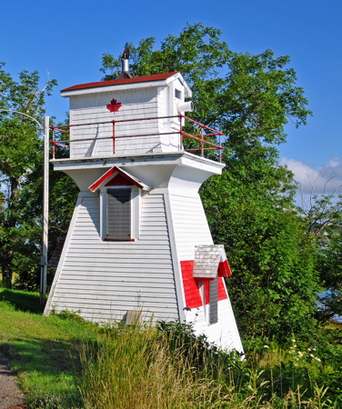
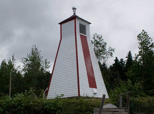
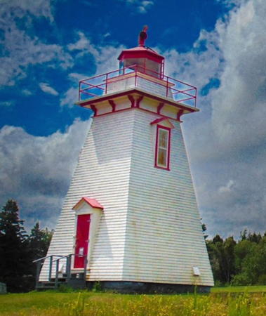
Wallace Sector Light, Wallace Harbour, August 2011
Wikimedia Creative Commons photo by Dennis Jarvis
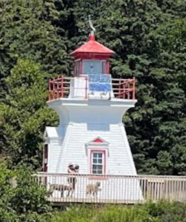

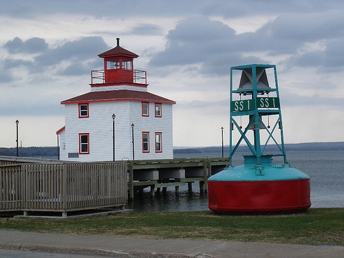
Pictou Island Wharf Light, Pictou Island, August 2023
Google Maps photo by Brent Rhynold
Cumberland County North Coast Lighthouses
Cumberland County spans the isthmus connecting Nova Scotia to New Brunswick. Lighthouses of its south and west coasts on the Bay of Fundy are described on the Western Nova Scotia page.
* Woody Point (Barnes Point) (relocated to Amherst Shore)
1911. Inactive since 1976. This was originally an 11 m (32 ft) square pyramidal wood tower located at Woody Point on the New Brunswick shore of Chignecto Bay. The lighthouse was sold after deactivation and relocated to private property in Nova Scotia. The owner built a large square room at the top of the tower and placed the lantern incongruously on its roof. Jarvis has a closeup photo and Google has a satellite view. Located in Amherst Shore, on Aggermore Point Road near the Amherst Shore Provincial Park. Site and tower closed. Owner/site manager: private.
* Coldspring Head
1890. Inactive since 2013. 11 m (36 ft) square pyramidal wood tower, painted white with red trim; lantern is red. Robert LeBlanc's 2023 photo is at right, Jarvis has an excellent 2011 photo, Bash has a photo, Claußen has closeup photos, NSLPS has photos by Marg Boak, Marinas.com has aerial photos, Peyton has a drone video, and Google has a satellite view. The lighthouse was built in connection with a project to build the Chignecto Ship Railway, designed to carry ships across the isthmus joining New Brunswick to Nova Scotia. The railway was never completed. Located near Northport on Cold Spring Head Road, off Lane 26 from NS 366. Site open, tower closed. Owner/site manager: Canadian Coast Guard. ARLHS CAN-144; ex-CCG A-941; ex-Admiralty H1302; ex-NGA 8504.
[Biglow Point Range Front (2?)]
Date unknown (station established 1909). Active; focal plane 15 m (49 ft); continuous green light. 5 m (17 ft) square skeletal tower carrying a daymark colored white with a red vertical stripe. No photo available but Google has a satellite view. The range guides vessels into Pugwash harbor. The original lighthouse was a 7 m (23 ft) square wood tower. Located at the end of Harbour Lane off highway 6 in West Pugwash. Site status unknown. Owner/site manager: Canadian Coast Guard. ARLHS CAN-1364; CCG A-927; Admiralty H1292; NGA 8512.
* [Biglow Point Range Rear (2?)]
Date unknown (station established 1909). Active; focal plane 28 m (92 ft); continuous green light. 11 m (35 ft) square skeletal tower carrying a daymark colored white with a red vertical stripe. Google has a street view and a satellite view. The original lighthouse was a 10 m (33 ft) square wood tower. Located just off highway 6, 479 m (0.3 mi) southeast of the front light. Site open, tower closed. Owner/site manager: Canadian Coast Guard. ARLHS CAN-1365; CCG A-928; Admiralty H1292.1; NGA 8516.

Coldspring Head Light, Northport, August 2023
Google Maps photo by Robert LeBlanc
* [Steven Point Range Front (2?)]
Date unknown (station established 1909). Active; focal plane 10 m (33 ft); continuous red light. 5.5 m (18 ft) skeletal tower carrying a trapezoidal daymark colored white with a red vertical stripe. Google has a street view and a satellite view. The original lighthouse was a 7 m (23 ft) square wood tower. Located at 166 Pugwash Point Road north of Pugwash. Site open, tower closed. ARLHS CAN-1377; CCG A-931; Admiralty H1296; NGA 8520.
[Steven Point Range Rear (2?)]
Date unknown (station established 1909). Active; focal plane 27.5 m (90 ft); continuous red light. 6 m (20 ft) skeletal tower carrying a trapezoidal daymark colored white with a red vertical stripe. No photo available but Google has a satellite view. Michel Forand contributed a historic photo of the original lighthouse, a 7 m (23 ft) square wood tower. Located in a farm field 470 m (0.3 mi) east of the front light. Site open, tower closed. ARLHS CAN-1378; CCG A-932; Admiralty H1296.1; NGA 8524.
#Pugwash (Fishing Point) (1) (relocated)
1871. Inactive since 1962 and destroyed in 2018. Approx. 11 m (36 ft) square cylindrical wood tower rising schoolhouse-style from the front of a 1-1/2 story wood keeper's house. Lighthouse painted white, lantern red. Donald Gorham has a 2010 closeup photo, Wikimedia has Jarvis's 2011 photo, Marinas.com has aerial photos, Huelse has a historic postcard view, and Google has a 2013 street view. The "schoolhouse" design is common in the U.S. but it is unusual for Nova Scotia. The lighthouse was sold to the Mundle family and they moved it to their farm. In recent years the lighthouse was allowed to deteriorate and in March 2018 the local fire department burned it as a practice exercise. This was a tragic loss for lighthouse fans. The lantern was saved, but it remains in private hands and its current location is not known. Google has a satellite view of the location. Located on Pugwash Point Road, off Gulf Shore Road on the north side of Pugwash. Site and tower closed, but the lighthouse can be seen easily from the road. Owner/site manager: private. ARLHS CAN-611.
* Pugwash (Fishing Point) (2)
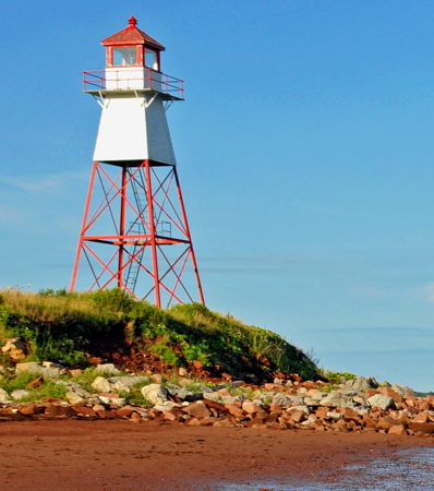
1962. Inactive since 2012. 15.5 m (51 ft) square steel skeletal tower with enclosed upper third. The skeletal tower and lantern are painted red, the enclosed watch room white. Wikimedia has Jarvis's photo, Nathalie D'Auteuil has a 2018 photo, Lighthouse Digest has Dana Rushton's photo, Donald Gorham has a view across the bay, and Google has a satellite view. The abandoned lighthouse is endangered. Located on the tip of Fishing Point north of Pugwash. Site open, tower closed. Owner/site manager: Canadian Coast Guard. . ARLHS CAN-419; ex-CCG A-926; ex-Admiralty H1290; ex-NGA 8508.

Fishing Point Light, Pugwash, August 2011
Wikimedia Creative Commons photo by Dennis Jarvis
* Mullins Point Range Rear (2) (relocated to North Wallace)
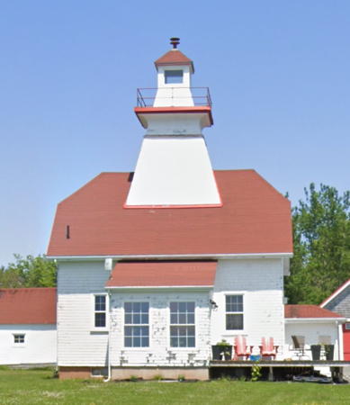
1894. Inactive since about 1965. 14.5 m (48 ft) square pyramidal wood tower with lantern centered on the roof of a 2-story wood keeper's house. Building painted white, lantern roof red. Google's 2023 street view is at right, the Nova Scotia Heritage Division has a photo, Nathalie D'Auteuil has a 2018 closeup photo, Wikimedia has Jarvis's 2011 photo, Lighthouse Digest has Michel Forand's photo, Bash has a distant 2008 view, Google has a good street view, and Google has a satellite view. This lighthouse is unique in the maritime provinces; it is a sibling of the Snug Harbour Range Rear and Jones Island Range Rear Lights, also built in 1894, on Georgian Bay, Ontario. The lighthouse was sold in 1966 to Mr. and Mrs. John Sproul, who relocated it to North Wallace on the point at the north side of the entrance to Wallace Harbour. Site and tower closed but the house can be seen easily from the road. Owner/site manager: private. ARLHS CAN-327.
* Wallace Harbour Sector (Wallace Harbor Range Front)
1904. Active; focal plane 12.5 m (41 ft); continuous light, white, red or green depending on direction. 8.5 m (28 ft) square pyramidal wood tower with rectangular wood lantern house. Lighthouse painted white with horizontal red bands on the water side. Jarvis's photo is at the top of this page, Margaret Berze has a 2021 photo, Bash has a 2008 photo, Trabas has Bash's photo, Claußen has a photo, Google has a street view, Marinas.com has aerial photos, and Google has a satellite view. The light guides vessels through the narrow channel into the harbor. The lighthouse, formerly operated as the front light of a range, was converted to a sector light in 1990; this required replacing the lantern room with a larger enclosure. Huelse has a postcard view showing the original appearance of the tower. In December 2015 the Wallace Area Development Association purchased the building for $1 and received a $10,000 grant for its future maintenance. Located beside NS 6 (Sunrise Trail) on the east side of Wallace Harbour (no parking provided). Site open, tower closed. Operator: Canadian Coast Guard. Owner/site manager: Wallace Area Development Association. . ARLHS CAN-518; CCG A-924; Admiralty H1283; NGA 8554.
Wallace Harbour Range Rear (relocated)
1904. Inactive since 1990. 14 m (46 ft) square pyramidal wood tower attached to a small service building. Building painted white, lantern roof red. Google has a satellite view. The lighthouse was deactivated after trees grew tall enough to obscure its light. The lighthouse was sold in 1994 and relocated in 1995 to Blue Sea Road near Malagash Point, about 18 km (11 mi) east of Wallace, where it is a private summer residence. Site and tower closed. Owner/site manager: private. ARLHS CAN-604.

Mullins Point Range Rear Light, North Wallace, June 2023
Google Maps street view

Pictou County Lighthouses
[Amet Island (3?)]
Date unknown. Active; focal plane 12 m (39 ft); white flash every 4 s. 7 m (23 ft) square cylindrical skeletal tower. The modern light stands beside the ruins of the original lighthouse, an 8 m (26 ft) light tower mounted on a keepers cottage. Nova Scotia Archives has a historic photo of the original lighthouse. A view of the modern light from the sea is available but the island is not seen in Bing's satellite view. The lighthouse was destaffed in 1921, so the present light is probably not the first skeletal tower to replace it. Amet Island is a small island in the entrance to Tatamagouche Bay. Located atop the island. Accessible only by boat; the island is a major nesting ground for cormorants and landing is not advised. Site and tower closed. Owner/site manager: Canadian Coast Guard. ARLHS CAN-1362; CCG A-921; Admiralty H1276; NGA 8564.
* Caribou (Caribou Island, Caribou Point) (3)
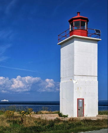
Around 1971 (station established 1868). Active; focal plane 13 m (44 ft); three white flashes, separated by 3 s, every 20 s. 12.5 m (40 ft) square cylindrical concrete tower formerly attached to a a 1-story utility building. Lighthouse painted white with red trim; lantern is red. Sarah Rumley's 2021 photo is at right, Hein Low has a 2018 photo, Jarvis has a good photo, Bash has a photo, Trabas has Bash's photo, John Carrigan has a closeup of the lantern, Claußen has a photo, Marinas.com has aerial photos, and Google has a distant satellite view. Michel Forand has a historic photo of the second lighthouse, built in 1916. In 2016 a new preservation group, Friends of Caribou Island Lighthouse began working to save the light station. In October 2016 the Coast Guard demolished the utility building, leaving only the tower standing. The Friends were pushing the Coast Guard to repaint and repair the tower in 2017 and they hope to have ownership transferred to the Municipality of the County of Pictou. The Coast Guard acted in July 2018 by repairing and repainting the tower; Sueann Musick's photo shows the start of this project. Located at Caribou Point on the north end of Caribou Island; the "island" is connected to the mainland by a narrow isthmus and is accessible by road from Waterside. There is also a good view of this light from ferries sailing between Caribou and Wood Islands, Prince Edward Island. Site open, tower closed. Owner/site manager: Canadian Coast Guard. ARLHS CAN-119; CCG A-918; Admiralty H1272; NGA 8576.
* Pictou Island South (Pictou Island West Wharf)
1907. Active; focal plane 11 m (35 ft); white light, 2 s on, 2 s off. 8 m (27 ft) square pyramidal wood tower, painted white; lantern is red. Brent Rhynold's 2023 photo is at the top of this page, Dan Parker has a closeup photo, Jon Clay has a good photo, and Google has a distant satellite view. From 1951 to 1974 the lighthouse served as the rear light of a range. The lighthouse was granted Heritage status in 2015. Pictou Island lies off the entrance to Pictou Harbour; it is accessible by passenger ferry from Caribou on a varying schedule May through November. Located near the southwestern tip of the island. Site open, tower closed. ARLHS CAN-380; CCG A-899; Admiralty H1237; NGA 8608.
* [Pictou Island West End (3)]
1965(?) (station established 1905). Active; focal plane 14 m (46 ft); white flash every 4 s. 7 m (23 ft) square skeletal tower carrying a daymark colored red with a white horizontal band. Google has an indistinct satellite view. The history of this light station is unclear. Nova Scotia Archives has a historic photo of the original lighthouse and it is also seen in the Lighthouse Digest photo. The foundation stones of this lighthouse are located near the modern light and according to Rip Irwin the foundation of the keeper's house also survives. Located on the western tip of Pictou Island. Site open, tower closed. Owner/site manager: Canadian Coast Guard. ARLHS CAN-381; CCG A-897; Admiralty H1244; NGA 8612.

Caribou Island Light, Pictou County, August 2021
Google Maps photo by Sarah Rumley
[Pictou Island East End (3?)]
1962(?) (station established 1853). Active; focal plane 18 m (56 ft); white flash every 4 s. 10 m (33 ft) square skeletal tower carrying a daymark colored red with a white horizontal band. Trabas has Bash's photo and Google has an indistinct satellite view. The original lighthouse, a square tower with attached keeper's house, was replaced in 1930 by the lighthouse seen in a historic photo. Sadly, no trace of the earlier lighthouses survives. Located on the eastern tip of Pictou Island. Site open, tower closed. Owner/site manager: Canadian Coast Guard. ARLHS CAN-379; CCG A-899.5; Admiralty H1238; NGA 8596.
Pictou Harbour Range Front (2)
1896 (station established 1889). Active; focal plane 8 m (28 ft); continuous white light. 7 m (23 ft) square pyramidal wood tower, painted white with a fluorescent red vertical stripe on the range line. Bash has the 2008 photo seen at right, Trabas has Bash's photo, Lighthouse Digest has Dana Rushton's photo, and Google has a satellite view. The range lights were relocated in 1909. Located on the north side of the entrance to Pictou Harbour. Site and tower closed, but the light can be seen from the nearby Harbour Light Campground. Owner/site manager: Canadian Coast Guard. ARLHS CAN-608; CCG A-903; Admiralty H1256; NGA 8620.
#Pictou Harbour Range Rear (2)
1896 (station established 1889). Inactive since 2012 and quickly demolished. This was an 11 m (38 ft) square pyramidal wood tower, painted white with a fluorescent red vertical stripe on the range line. Bash has a 2008 photo, Trabas has Bash's photo, and Lighthouse Digest has Dana Rushton's photo. The range lights were relocated in 1909. In 2012 the rear light (focal plane 17 m (56 ft); continuous white light) was moved to a square skeletal tower 140 m (460 ft) west of the front light. Darlene Chisholm visited this station in 2016 and found that the historic lighthouse had been removed. Chisholm supplied the photo of the new light on Anderson's site and Google has a satellite view of the former location. Located on the north side of the entrance to Pictou Harbour. Site and tower closed, but the light can be seen from the nearby Harbour Light Campground. Owner/site manager: private. ARLHS CAN-378. Current light: CCG A-904; Admiralty H1256.1; NGA 8624.

Pictou Harbour Range Front Light, Pictou Harbour, June 2008
photo copyright Charles Bash; used by permission

#[Pictou]
Date unknown (station established 1958). Inactive since 2022 and immediately demolished. This was a 12.5 m (41 ft) square cylindrical skeletal tower, painted red. Google has a 2014 street view. This light replaced the light on the Customs House (see below). A 2022 Google street view confirms the removal. Located on a hilltop at Front and Welsford Streets on the east side of the Pictou waterfront. Site open, tower closed. ex-CCG A-906; ex-Admiralty H1248.1; NGA 8617.
** [Pictou Lighthouse Museum]
2008. Inactive. Approx. 9 m (30 ft) square lantern and gallery centered on a square 2-story wood museum. Anna Webber's photo is a right, Bash has a 2008 photo, Joseph Barss has a 2023 closeup, and Google has a street view and a satellite view. This building is designed as a 2/3 scale replica of the 1916 Caribou Light; although based on original blueprints it differs from the original in many details. The building houses the large collection of lighthouse photos and artifacts assembled by Rip Irwin, the leading researcher of Nova Scotia lighthouses. Located at the end of a short pier on the Pictou waterfront. Site open, museum open daily except Sundays during the summer season. Owner/site manager: Northumberland Fisheries Museum.
* [Pictou Customs House]
1878. Inactive since 1958. 3-story brick building. There was formerly a tower at the front of the building, topped by a pyramidal roof; a drawing is available. A modern photo is available and Google has a street view and an indistinct satellite view. Shown through a window of the tower, the light served as the rear light of a range with the Pictou Bar lighthouse (see below) as the front light. The tower was destroyed by Hurricane Edna in September 1954, although a light continued to be displayed for several more years. The building is now an inn with overnight accommodations available. Located at the foot of Depot Street, next to the Fisheries Museum. Site and building open. Owner/site manager: Customs House Inn.
Pictou Lighthouse Museum
Pictou Lighthouse Museum, Pictou, April 2009
ex-Flickr Creative Commons photo by Anna Webber
* Trenton Range Front (Stonehouse Point) (2)
1962 (station established 1920). Inactive since 2018. 4.5 m (15 ft) square pyramidal wood tower, originally painted white with a red vertical stripe on the range line. Lantern removed. Trabas has Bash's photo, and Google has a street view and an indistinct satellite view. Nathalie D'Auteuil's 2018 photo shows the lighthouse much in need of paint, while Google's October 2021 street view shows the tower repainted in a dark blue color. The rear range light was on a 10 m (33 ft) square cylindrical skeletal tower, which apparently survives. Originally both lights were on posts. Located at Stonehouse Point on the south side of the entrance to Trenton Harbour from the East River estuary about 15 km (9 mi) southeast of Pictou. Site open, tower closed. Owner/site manager: Canadian Coast Guard. ARLHS CAN-505; ex-CCG A-910; ex-Admiralty H1264; ex-NGA 8640.
#Pictou Bar (Lighthouse Beach) (2)
1903 (station established 1834). Destroyed by fire in 2004. The lighthouse was an 11.5 m (37 ft) octagonal pyramidal wood tower, painted white with red vertical striping and a red lantern. The tower burst into flames on the evening of 5 July 2004 and local firefighters were not able to bring their equipment onto the beach to save the lighthouse. Claußen has a photo taken only a few weeks before the disaster and Google has a satellite view of the former location. Heritage Canada recognized this tragedy as one of the five worst historic structure losses of 2004. Anderson has a 2008 photo of the active light (focal plane 9 m (30 ft); white flash every 4 s) on a 7 m (23 ft) square skeletal tower; it has been renamed the Lighthouse Beach Light. Although a restoration commitee was quickly formed, it does not appear that the historic lighthouse will be rebuilt. Huelse has a historic postcard view of the original lighthouse; ironically it was also destroyed by fire in May 1903. Located at the end of the spit on the east side of the entrance to Pictou; accessible by walking the beach. Site open. Owner/site manager: Canadian Coast Guard. Original light: ARLHS CAN-377; ex-Admiralty H1248. Current light: CCG A-906.4; Admiralty H1248.05; NGA 8616.
Merigomish (King Head)
1882. Inactive since 1897. 10 m (33 ft) square wood tower, lantern removed, attached to a 1-1/2 story house. Lighthouse painted white. The original keeper's house has been expanded into a modern dwelling. Google has a satellite view. Located at the end of Lighthouse Road on King Head, on the western side of the entrance to Merigomish Harbour about 20 km (13 mi) east of Pictou. Site and tower closed (private property); the lighthouse is best seen from the water. Owner/site manager: private.

Antigonish County (St. Georges Bay) Lighthouses
** Arisaig (replica)
2007 (replica of 1898 lighthouse). Inactive. Approx. 8 m (26 ft) square wood tower with lantern and gallery, painted white with red trim. Jordan Crowe has a closeup, Wikimedia has Jarvis's photo, Paul Smith has a 2022 photo, Gabriel Robertson has a 2020 sunset photo, and Google has a street view and a satellite view. The original lighthouse burned in 1939 and was not replaced. The replica follows the general design of the original but it is larger and differs in various details. The lighthouse was built by volunteers in 2007 as part of a community improvement effort. Parking is provided and interpretative displays tell the story of the village's Highland Scot heritage. May MacKenzie has a photo of the active Arisaig West Light (focal plane 10.5 m (34 ft); green light, 2 s on, 4 s off) on the west breakwater of Arisaig Harbour. Located on Arisaig Point, near the harbor, about 35 km (22 mi) southwest of Cape George. Site open, tower open during the summer season. . ARLHS CAN-1272. Arisaig West Light: CCG A-894.1; Admiralty H1234.8.
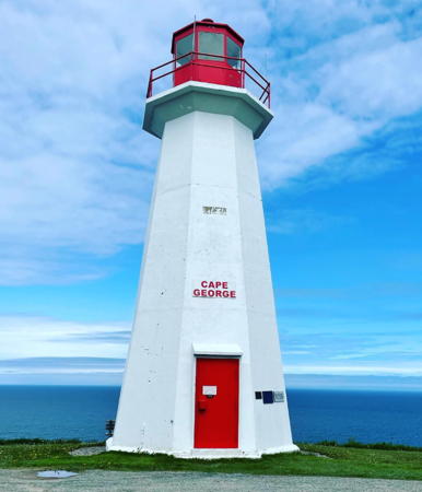
** Cape George (Antigonish) (3)
1968 (station established 1861). Active; focal plane 123 m (404 ft); three white flashes, separated by 2 s, every 12 s. 14 m (45 ft) octagonal concrete tower, painted white; lantern is red. 1-1/2 story keeper's house (1908) and barn. Anna Dalzell's 2023 photo is at right, Anderson has a good page for the lighthouse, Andrew Tomlinson has a 2021 photo, Wikimedia has Jarvis's photo, Trabas has Bash's photo, Claußen has photos, Robert Ciavarro has a good 2007 photo, Marinas.com has aerial photos, and Google has a street view and a satellite view. This is one of two Cape George Lights in Nova Scotia; the other is on Bras d'Or Lake (see the Cape Breton Island page). Michel Forand has a historic photo of the 1908 lighthouse that replaced the original lighthouse; Anderson has a photo showing both of those lighthouses. The lighthouse was transferred to community ownership in late 2016. Built on a spectacular bluff overlooking the entrance to St. George's Bay. Located at the end of Lighthouse Road, off NS 337 near Ballantyne's Cove. Accessible by road and the entrance from NS 337 is well marked. Limited parking available. Site open, tower closed. Owner/site manager: North Shore Development Association. . ARLHS CAN-098; CCG A-892; Admiralty H1234; NGA 8664.
Pomquet Island (3)
1959 (station established 1868). Active; focal plane 9 m (30 ft); white flash every 4 s. 8.5 m (28 ft) square pyramidal wood tower with lantern and gallery, painted white. Charlene Meisner-MacDonald has a 2013 photo, Bryan Juurlink has a 2008 photo, Nathalie D'Auteuil has a 2018 view from the sea, Marinas.com has aerial photos, and Google has a satellite view. The original lighthouse was a keeper's dwelling, the light being shown through a window. In 1910 a square light tower was attached to the building. Foundation ruins of the keeper's house survive. The island is in St. George's Bay about 3 km (2 mi) off Bayfield. Owner/site manager: Canadian Coast Guard. . ARLHS CAN-402; CCG A-888; Admiralty H1232; NGA 8676.

Cape George Light, Ballantynes Cove, June 2023
Instagram photo by Anna Dalzell
#Havre Boucher Range Front (2)
1879 (station established 1842). Demolished in 2010. This was a 9 m (29 ft) square pyramidal wood tower, painted white with a red vertical stripe on the range line; lantern painted red. Bash has a 2008 photo, Trabas also has Bash's photo, Claußen has 2004 photos, Marinas.com has aerial photos, and Google has a satellite view. The lighthouse was badly deteriorated, so the Coast Guard replaced it with a short square skeletal tower (focal plane 9 m (29 ft); continuous green light). Located on the southwest side of the harbor; railway tracks separate the lighthouse from the coastal road. Site open, tower closed. Site manager: Canadian Coast Guard. ARLHS CAN-609. Current light: CCG A-884; Admiralty H1230; NGA 8688.
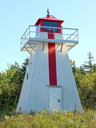
* Havre Boucher Range Rear (3)
2010 (station established 1842). Active; focal plane 33 m (108 ft); continuous green light. 9 m (29 ft) square pyramidal skeletal tower, covered with vinyl siding colored white with a red vertical stripe on the range line; lantern is red. The new lighthouse is similar in appearance to the 1879 wood lighthouse it replaced. Dennis Jarvis's 2022 photo is at right, Colin Slaps has a 2023 photo, and Google has a satellite view and a 2012 street view. Bash has a 2008 photo of the older lighthouse, Trabas also has Bash's photo, Claußen has a photo, and Marinas.com has aerial photos. This lighthouse was a pilot project; in recent years several other traditional pepperpot lighthouses have been replaced with vinyl-clad replicas. Located 435 m (1/4 mi) south of the front light, on a hill above NS 4, just off the Trans-Canada Highway at the Havre Boucher exit. Site open, tower closed. Site manager: Canadian Coast Guard. ARLHS CAN-224; CCG A-885; Admiralty H1230.1; NGA 8692.
#[North Canso (2)]
1966 (station established 1842). Inactive since 2013 and demolished in 2017. This was a 10.5 m (35 ft) slender steel (?) pillar, painted white with two narrow horizontal red bands. Jordan Crowe has a 2010 photo. Bing has a satellite view of the fomer location. This modern tower replaced a historic 2-story keeper's house with light tower on the roof. Located on the west side of the northern entrance to the Strait of Canso, about 2 km (1.25 mi) north of East Havre Boucher. Accessible by 4WD vehicles. Site open, tower closed. Site manager: Canadian Coast Guard. ARLHS CAN-344; ex-CCG A-883; ex-Admiralty H3440; ex-NGA 8696.

Havre Boucher Range Rear Light, Havre Boucher, August 2012
Wikimedia Creative Commons photo by Dennis Jarvis

Information available on lost lighthouses:

Notable faux lighthouses:

Adjoining pages: North: Eastern Prince Edward Island | East: Cape Breton Island | South: Western Nova Scotia | West: Northern New Brunswick

Return to the Lighthouse Directory index | Ratings key

Posted December 18, 2002. Checked and revised March 24, 2024. Lighthouses: 18. Site copyright 2024 Russ Rowlett and the University of North Carolina at Chapel Hill.