Lighthouses of the United States: New Hampshire

The United States of America is a federal union of 50 states and a capital district. The northeastern state of New Hampshire has a very short Atlantic coastline, just 18 miles (29 km) long, wedged between Maine and Massachusetts. There are two coastal lighthouses and three state-approved, privately maintained lighthouses on Lake Sunapee. Both coastal lights are the objects of well-organized preservation efforts.

The Whaleback Light in the harbor of Portsmouth, New Hampshire, is actually in Maine waters, so it is listed under that state.

New Hampshire is divided into ten counties.

Coastal aids to navigation in New Hampshire are maintained by the U.S. Coast Guard Sector Northern New England and its Aids to Navigation Team based at South Portland, Maine, but ownership (and sometimes operation) of historic lighthouses has been transferred to local authorities and preservation organizations in many cases.

ARLHS numbers are from the ARLHS World List of Lights. Admiralty numbers are from volume J of the Admiralty List of Lights & Fog Signals. USCG numbers are from Vol. I of the USCG Light List.

General Sources
New England Lighthouses: A Virtual Guide - New Hampshire
Historical information and photos for all of the lighthouses.
New Hampshire Lighthouses
Excellent photos and accounts by Kraig Anderson.
Online List of Lights - New Hampshire
Photos by various photographers posted by Alexander Trabas.
Lighthouses in New Hampshire
Photos by various photographers available from Wikimedia.
Lighthouses in New Hampshire
Aerial photos posted by Marinas.com.
Leuchttürme der USA auf historischen Postkarten
Historic postcard images of U.S. lighthouses posted by Klaus Huelse.
U.S. Coast Guard Navigation Center: Light Lists
The USCG Light List can be downloaded in pdf format.
NOAA Nautical Charts
Nautical charts for the coast can be viewed online.
Navionics Charts
Navigation chart of Lake Sunapee.


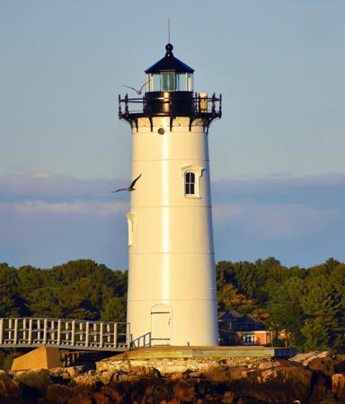
Portsmouth Harbor Light, Portsmouth, October 2021
Instagram photo by Kelly Ryan

Atlantic Coast (Rockingham County) Lighthouses
** Portsmouth Harbor (New Castle, Fort Point, Fort Constitution) (4)
1878 (James C. Duane). Station established in 1771. Active; focal plane 52 ft (16 m); continuous green light. 48 ft (14.5 m) round cast iron tower with lantern and gallery; a 4th order Fresnel lens installed sometime after 1935 is in use. Tower painted white, lantern and gallery black. Fog horn (blast every 10 s). 1-1/2 story wood keeper's house (1872) and brick oil house. Kelly Ryan's 2021 photo appears above, Anderson also has a good page for the lighthouse, a good 2010 photo is available, Marinas.com has aerial photos, Huelse has a historic postcard view, Andreas Ziebart has a street view, and Google has a satellite view. In 1998 the Coast Guard repainted the tower after removing lead paint from the outside and inside. Early in 2000 the American Lighthouse Foundation leased the tower for preservation. A support group, Friends of Portsmouth Harbor Light, works for preservation and restoration of the light station. In May 2004 the oil house was restored by Campbell Construction. In 2006 the walkway to the light station was rebuilt to improve access. In 2010 the lighthouse was repainted with $30,000 raised mostly by the Friends group. In 2017 a small museum exhibit was installed in the restored oil house. By 2019 it was time to repaint again; the J.B. Leslie Company repainted the tower and recaulked the lantern room. In January 2024 storms damaged the oil house and broke up much of the concrete base supporting the lighthouse. Located on the grounds of the Portsmouth Harbor Coast Guard Station, adjacent to the Fort Constitution State Historic Site and off NH 1B in New Castle. Site open, tower open on Friday and Sunday afternoons from late May to mid October. Owner: U.S. Coast Guard. Site manager (tower): Friends of Portsmouth Harbor Lighthouse . ARLHS USA-662; Admiralty J0234; USCG 1-8330.
Isles of Shoals (White Island) (2)
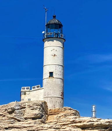
1859 (station established 1821). Active; focal plane 82 ft (25 m); white flash every 15 s. 58 ft (17.5 m) round cylindrical brick tower with lantern and gallery; solar-powered 190 mm lens. Tower painted white, lantern black. Fog horn (blast every 30 s) operates continuously. The 1-1/2 story keeper's house is leased to a diving school. The station also includes a NOAA C-MAN automatic weather station. A 2022 photo is at right, Anderson also has a good page for the lighthouse, a 2009 photo is available, Marinas.com has aerial photos, Blaine Kopp has a street view from the lantern, Huelse has a historic postcard view, and Google has a satellite view. In 1993 ownership of the light station was transferred to the state of New Hampshire, but the state proceeded to ignore the lighthouse completely. By 2001 the tower was in poor condition, riddled with cracks; it was placed on the Lighthouse Digest Doomsday List in March 2002. A local school group, the Lighthouse Kids, drew public attention to the plight of the lighthouse. In 2003 the Lighthouse Kids successfully lobbied the state legislature for $125,000 to repair the tower, and in April of the same year a $250,000 federal grant for restoration was announced. In May 2005 another $50,000 grant was received. During the summer of 2005 contractors carried out a complete restoration of the tower and a partial restoration of the keeper's house. In April 2007 a powerful nor'easter, known in New England as the Patriot's Day storm, washed completely over the island, damaging the newly restored lighthouse. The solar panels, foghorn, and walkway connecting the tower and keeper's house were all destroyed, and the covering of the tower was damaged. The walkway was replaced in 2011 with federal damage restoration funds from FEMA. In 2008 the lens was replaced by a modern VLB-44 LED unit. The Isles of Shoals are a group of 18 islands and rocks 9 miles (15 km) southeast of Portsmouth and lying partly in Maine and partly in New Hampshire. The New Hampshire portion of the Isles comprise a state park. Accessible only by boat; cruises from Portsmouth pass the site. Site open, tower closed. Owner/site manager: N.H. Division of Parks and Recreation (White Island State Historic Site ). ARLHS USA-406; Admiralty J0246; USCG 1-0235.

White Island Light, Isles of Shoals, September 2022
Instagram photo by Jessica S.

Lake Sunapee (Merrimack and Sullivan Counties) Lighthouses
Lake Sunapee is located east of Newport in southwestern New Hampshire, on the boundary between Merrimack and Sullivan Counties. The lake is about 8 miles (13 km) long and up to 2.5 miles (4 km) wide.

Herrick Cove
1893 (rebuilt in 2004). Active; focal plane 27 ft (8 m); white light, pattern unknown. 27 ft (8 m) hexagonal wooden tower, painted white; no lantern. Anderson has a page for the lighthouse, Nikki McLeod has a closeup photo, Jim Davis has a 2007 photo, Ben Tolosa has a drone view, and Google has a satellite view. This is the only survivor of three lighthouses built by a company that operated steamships on the lake in the 1890s. The tower was refurbished in 1960 and repaired after being damaged by ice in 1983. In late September 2003 the lighthouse was lifted to shore by helicopter so that its foundation could be repaired; the restoration was completed in July 2004. Located on a rock just offshore at the southern entrance to Herrick Cove, on the northwestern shore of the lake near Georges Mills in Merrimack County. Accessible only by boat; visible from tourist cruises of the lake. Site and tower closed. Owner: New Hampshire Marine Patrol Unit. Site manager: Lake Sunapee Protective Association. . ARLHS USA-967.
Loon Island (2)
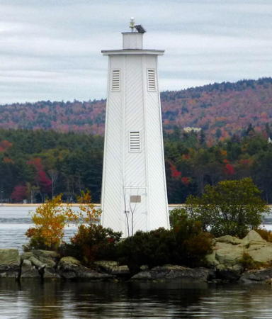
1960 (replica of 1893 tower). Active; focal plane 27 ft (8 m); white light, pattern unknown. 25 ft (7.5 m) hexagonal wooden tower, painted white; no lantern. The original lighthouse was destroyed by fire after by a lightning strike in 1960. Tim Horvath's photo is at right, Anderson also has a page with good photos, Huelse has a historic postcard view, and Google has a satellite view. Located on a rocky ledge in the center of the lake off Sunapee in Sullivan County. Accessible only by boat; visible from tourist cruises of the lake. Site and tower closed. Owner: New Hampshire Marine Patrol Unit. Site manager: Lake Sunapee Protective Association. . ARLHS USA-968.
Burkehaven (2)
1983 (replica of 1893 tower). Active; focal plane 20 ft (6 m); white light, pattern unknown. 20 ft (6 m) hexagonal wooden tower, painted white; no lantern. The original lighthouse was destroyed by ice in 1935. In 1994 ice damaged the crib on which the lighthouse stands, so it had to be repaired again. Anderson's page has good photos, Kara Obey has a 2018 photo, and Google has a satellite view. Located on a rock just offshore at Burkehaven, south of Sunapee in Sullivan County. Accessible only by boat; visible from tourist cruises of the lake. Site and tower closed. Owner: New Hampshire Marine Patrol Unit. Site manager: Lake Sunapee Protective Association. . ARLHS USA-966.

Loon Island Light, Lake Sunapee, March 2018
Instagram photo by Tim Horvath

Information available on lost lighthouses:

Notable faux lighthouses:

Adjoining pages: North: Southern Maine | South: Northern Massachusetts

Return to the Lighthouse Directory index | Ratings key

Posted in May 2001. Checked and revised May 19, 2024. Lighthouses: 5. Site copyright 2024 Russ Rowlett and the University of North Carolina at Chapel Hill.