Lighthouses of Norway: Outer Lofoten

The Kingdom of Norway (Norge in Norwegian) is one of the world's most maritime nations. The country is long and narrow, with drowned valleys called fjords that bring the sea far inland in most regions. The mainland coast is estimated to be 2650 km (1650 mi) long and when all the islands and minor indentations are counted the total coastline approaches an astonishing 60,000 km (37,500 mi), long enough the go around the world one and a half times. With such a lengthy and rocky shore it's not surprising that Norway has a large number of lighthouses.

The Lofoten Islands are located in Nordland County off the northwestern coast of Norway. Located entirely north of the Arctic Circle, the mountainous islands are known for their spectacular scenery with dramatic mountains rising from the sea; as a result they attract many visitors. Historically they have also been a center of the Norwegian fishing industry with many small fishing harbors nestled amid the mountains.

Norway is divided into counties (fylker) and the counties are divided into townships (kommuner). This page describes lighthouses of the outer Lofoten islands in the townships of Flakstad, Moskenes, Værøy, and Røst. Flakstad and Moskenes are accessible by road while Værøy and Rust are reached only by boat.

In Norwegian a lighthouse is a fyrtårn (fire tower) or simply a fyr; a fyrlykt is a beacon and a lyktehus is a lantern. Øy is an island, holmen is an islet, skjær is a skerry (a tiny island or rocky reef), sund is a strait (often between an island and the mainland), bukt is a bay, nes is a headland, and havn is a harbor.

Aids to navigation in Norway are maintained by the Kystverket (Coast Directorate), an agency of the Ministry of Transport and Communications.

ARLHS numbers are from the ARLHS World List of Lights. NF numbers are from the Norsk Fyrliste. Admiralty numbers are from volume L of the Admiralty List of Lights & Fog Signals. U.S. NGA List numbers are from Publication 115.

General Sources
Norsk Fyrhistorisk Forening
News and photos from the Norwegian Lighthouse Association.
Online List of Lights - Norway
Photos by various photographers posted by Alexander Trabas. Most of the photos for this area are by Capt. Peter Mosselberger (Capt. Peter).
Lighthouse Pages from Anke and Jens - Norway
Excellent photos of more than 60 Norwegian lighthouses.
Leuchttürme an der norwegischen Küste
Photos posted by Bernd Claußen.
Lighthouses in Nordland
Photos by various photographers available from Wikimedia.
Norwegische Leuchttürme auf historischen Postkarten
Historic postcard images posted by Klaus Huelse.
Liste over Norske Fyr
From Wikipedia, a handy list of Norwegian light stations with their dates of establishment.
Norsk Fyrliste
The official Norwegian light list can be downloaded in six .pdf volumes.
GPSNavigationCharts
Navigation chart information for this area.
Navionics Charts
Navigation chart information for Nordland.


1857 Glåpen Light, Sørvågen, May 2015
Flickr Creative Commons photo by Kjell Jøran Hansen


Værøy Light, Værøy, June 2018
Google Maps photo by Liss M

Flakstad Lighthouses

Innerside (Sund Area) Lighthouses
Hysskjæret (Skjelfjorden)
Date unknown. Active; focal plane 7 m (23 ft); white, red or green light depending on direction, 2 s on, 2 s off. 8 m (26 ft) lantern and gallery mounted on quadrupod piles. Lantern painted white with a red roof; piles painted black. Trabas has Capt. Peter's photo and Bing has a satellite view. Located in the Skjelfjord about 5 km (3 mi) northeast of Sund. Accessible only by boat. Site open, tower closed. NF-761600; Admiralty L2968; NGA 11708.
Sund
Date unknown. Active; focal plane 12.5 m (41 ft); white, red or green light depending on direction, 1 s on, 1 s off. 7 m (23 ft) lantern and gallery mounted on a stone cairn. Trabas has Capt. Peter's photo and Bing has a satellite view. Google has a street view of a white lantern, probably from this light, on display outside the Sund Fisheries Museum (Sund Fiskerimuseum). The current lighthouse is located on the southern tip of the island of Grimsholmen, marking the entrance to Sund harbor. Accessible only by boat. Site open, tower closed. NF-762100; Admiralty L2972; NGA 11716.

Outerside (Flakstad Area) Lighthouses
Moholmen (Flakstad Moholmen)
Date unknown. Active; focal plane 12 m (39 ft); flash every 5 s, white, red or green depending on direction. 6.5 m (21 ft) concrete post with lantern and gallery. Trabas has Capt. Peter's distant photo and Bing has a satellite view. Note: there is a better-known Moholmen Light in the Vestfjord near Kabelvåg (see the Inner Lofoten page). Located on a small island off the northern tip of Moskenesøy. Accessible only by boat. Site open, tower closed. NF-774000; Admiralty L3033; NGA 11912.
Leiholmen
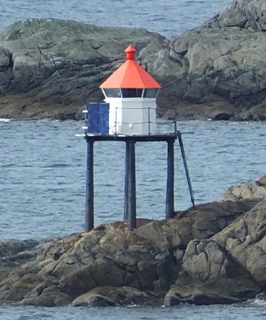
Date unknown. Active; focal plane 7 m (23 ft); white, red or green light depending on direction, occulting twice every 8 s. 6 m (20 ft) lantern and gallery mounted on quadrupod piles. Lantern painted white with a red roof; piles painted black. Trabas has Capt. Peter's photo (also seen at right) and Bing has a satellite view. Located on a skerry off the north coast of Moskenesøy, about 2 km (1.25 mi) southeast of the Moholmen light. Accessible only by boat. Site open, tower closed. NF-774200; Admiralty L3034; NGA 11916.
Hornneset
Date unknown. Active; focal plane 40 m (131 ft); two flashes every 5 s, white, red or green depending on direction. 5.5 m (18 ft) concrete post with lantern and gallery. No photo available but Google has a satellite view. Located on a prominent cape at the northern tip of Flakstadøy. Site status unknown; this location is quite remote. NF-776600; Admiralty L3050; NGA 11964.
Hundholmen
Date unknown. Active; focal plane 13.5 m (44 ft); white, red or green light depending on direction, occulting twice every 8 s. 8.5 m (28 ft) lantern and gallery mounted on quadrupod piles. Lantern painted white with a red roof; piles painted black. Trabas has Capt. Peter's photo and Bing has a satellite view. Located on a skerry off the entrance to the Nappstraum, the channel separating Flakstad from Vestvågøy. Accessible only by boat. Site open, tower closed. NF-776800; Admiralty L3051; NGA 11968.

Leiholmen Light, Flakstad
photo copyright Capt. Peter Mosselberger; used by permission

Moskenes Lighthouses

Reine Lighthouses
* Olnilsøy (Reine) (3?)
2013 (?) (station established 1862). Active; focal plane 14 m (46 ft); white, red or green light depending on direction, 2 s on, 2 s off. 6.5 m (26 ft) concrete post with lantern and gallery. Lighthouse painted white with one black horizontal band; lantern roof painted red. Trabas has Capt. Peter's photo and Bing has a satellite view of the station. The new lighthouse is also seen at the far right in Martin Stelbrink's photo of the Reine Pier light. The previous lighthouse was a square wood tower with lantern and gallery. The original 2-story lighthouse was swept away by a storm during the winter of 1924-25. Located at the southwestern tip of Olnilsøy, opposite the harbor of Reine. Accessible by road. Site open, tower closed. NF-763600; Admiralty L2980; NGA 11728.
* Reine Pier (Fiskskjæret) (2)
2002(?). Active; focal plane 8 m (26 ft); white, red or green light depending on direction, occulting three times every 10 s. Approx. 7 m (23 ft) concrete post with lantern and gallery. Lighthouse painted white with one black horizontal band; lantern roof painted red. Tomas Kohout's photo is at right, Trabas has Capt. Peter's photo, Marco Franchino has another excellent photo, Ion Nela has a 2022 photo, Florian Smit has a photo showing this light and the Olnilsøy light, Mikkel Bekker has a wintry street view, Wikipedia has an aerial photo of the harbor showing both lights on the right, and Bing has a satellite view. The earlier Fiskskjæret light was on piles atop a skerry; this light replaced it when the pier was extended to the skerry. The light lists have not been updated and still describe the original light. Located at the end of a pier projecting northward from Moskenes and sheltering the harbor of Reine. Accessible by walking the pier. Site open, tower closed. NF-763800; Admiralty L2982; NGA 11732.
Reine Pier Light
Reine Pier Light, Reine, July 2013
ex-Panoramio photo copyright Tomas Kohout; used by permission

Sørvågen and Southern Moskenes Lighthouses
* Moskenesvågen Øst
2014. Active; focal plane 7.5 m (25 ft); green light, 2 s on, 2 s off. 5 m (17 ft) round cylindrical fiberglass tower with lantern and gallery. Tower colored green, lantern white with a red roof. Trabas has Capt. Peter's photo and Google has a satellite view. Located at the end of the east breakwater of Moskenes harbor. Accessible by walking the pier. Site open, tower closed. NF-764801; Admiralty L2988.4.
* Moskenes Havn
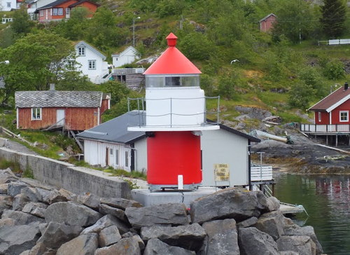
2014. Active; focal plane 8 m (26 ft); white or red light, depending on direction, occulting twice every 8 s. 4.5 m (16 ft) round cylindrical fiberglass tower with lantern and gallery. Tower colored red, lantern white with a red roof. Trabas has Capt. Peter's photo, Arno Siering's photo is at right, and Google has a satellite view. Located at the end of the west breakwater of Moskenes harbor. Accessible by walking the pier. Site open, tower closed. NF-764900; Admiralty L2988.2.
#Moskenes (Pråslodden) (1)
Date unknown (station established 1898). Replaced (inactive 2014-2017); no light characteristic data available. As of 2014 this was a lantern and gallery mounted on an octagonal stone base. Lantern painted white with a red roof. Bing has a satellite view. The light lists all dropped this light in 2014 but since 2017 it has reappeared on the Fyrliste but with no data given. A 2022 view from the harbor shows a small post light; Navionics does not chart it. Located on a rocky promontory on the west side of the entrance to Sørvågen's ferry harbor. There is (was?) a good view of this light from ferries arriving from Bodø on the mainland. Site open, tower closed. ex-Admiralty L2988; ex-NGA 11748. Active light: NF-765000.
* Glåpen (1)
1857. Inactive since 1985. 7 m (23 ft) square wood tower with a large lantern and gallery, attached to the front of a 1-1/2 story keeper's house. Lighthouse painted white, lantern red. Kjell Jøran Hansen's photo is at the top of this page, Anke and Jens have photos, Wayne Hopkins has a fine photo, a 2007 photo and Clemens Gilles's 2013 photo show both Glåpen lighthouses, the Lighthouse Association has a page for the lighthouse, and Bing has a satellite view of the station. Located on a promontory marking the west side of the entrance to the harbor of Sørvågen. Accessible by road. Site open, tower closed. . ARLHS NOR-098.

Moskenes Havn Light, Moskenes, July 2015
ex-Panoramio photo copyright Arno Siering; used by permission
* Glåpen (2)
1985 (station established 1857). Active; focal plane 44 m (144 ft); white or red light, depending on direction, occulting once every 6 s. 8 m (26 ft) concrete post with lantern and gallery. Tower painted white with one black horizontal band, lantern roof is red. Trabas has Capt. Peter's photo, a fine 2008 photo is available, and Bing has a satellite view. Located in front of the historic lighthouse. Site open, tower closed. ARLHS NOR-429; NF-765400; Admiralty L2990; NGA 11752.
* [Å (Å i Lofoten, Åkerbjerget)]
Date unknown (station established 1898). Active; focal plane 12.5 m (41 ft); white, red or green light depending on direction, occulting three times every 10 s. 3 m (10 ft) octagonal lantern, painted white with a red roof. Gregor Samsa has a closeup photo, Trabas has Capt. Peter's photo and Bing has a distant satellite view. For sure this lighthouse holds the world record for the shortest name. Located on Åkerbjerget, a promontory on the east side of the entrance to Å harbor, about 3 km (2 mi) southwest of Sørvågen. Site open, tower closed. NF-766000; Admiralty L2994; NGA 11772.
Yttertuven (2)
Date unknown. Active; focal plane 29 m (95 ft); white, red or green light depending on direction, 2 s on, 2 s off. 6 m (20 ft) round cylindrical fiberglass tower with lantern and gallery. Lighthouse colored white with one black horizontal band; lantern roof is red. Trabas has Rainer Arndt's photo and Bing has a satellite view. This light marks the southeasternmost tip of Moskenesøy, and thus the exit from the Vestfjord to the Norwegian Sea. The earlier lighthouse was a square wood tower. Accessible only by boat. Site open, tower closed. NF-767000; Admiralty L2995; NGA 11776.

Værøy Lighthouses

Værøy, also called Sørland after its one settlement, is one of the outermost of the Lofoten Islands, about 18 km (11.5 mi) west southwest of Sørvågen.

Skarvholmen
Date unknown. Active; focal plane 20 m (66 ft); white, red or green light, depending on direction, 2 s on, 2 s off. 14 m (46 ft) lantern mounted on a platform supported by piles. Lantern painted white with a red roof. No photo available but Bing has a distant satellite view. Located on a skerry about 8 km (5 mi) north of Værøy. Accessible only by boat. NF-769000; Admiralty L3005; NGA 11800.
Kvitholmen
Date unknown. Active; focal plane 13.5 m (44 ft); two flashes every 5 s, white, red or green depending on direction. 5.5 m (18 ft) concrete post with lantern and gallery. Lighthouse painted white, lantern roof red. No photo available but Bing has a distant satellite view. Located on Kvitholmen, a small island at the northeastern corner of Værøy. Accessible only by boat. NF-768500; Admiralty L3003.4; NGA 11792.
* Værøy
1880. Inactive since 2007. 15 m (49 ft) square cylindrical stone tower with lantern and gallery, rising from a 1-1/2 story stone keeper's house. Lighthouse painted white; lantern roof is red. A photo is at the top of this page, the Lighthouse Association has a page for the lighthouse, Stefan Cruysberghs has a good photo, a 2011 photo is available, a closeup is available, and Google has a distant street view and an indistinct satellite view of the station. The lighthouse was deactivated when the interior of the lighthouse was gutted by fire in 2007. The Kystverket restored the exterior and in 2015 it leased the lighthouse to a small group, with a financial grant to restore the interior. The restoration was complete by 2019 and the lighthouse is now available for overnight accommodations. Located at the east side of the entrance to the harbor of Sørland. A road leads to or close to the lighthouse. Site open, tower closed. Site manager: Lofoten Fyr (Værøy Fyrstasjon) . ARLHS NOR-279; ex-Admiralty L3000; ex-NGA 11804.
Sørlandsvåg
Date unknown. Active; focal plane 7 m (23 ft); white, red or green light depending on direction, occulting twice every 8 s. 6 m (20 ft) concrete post with lantern and gallery. Lighthxouse painted white, lantern roof red. Google has a street view and Bing has a distant satellite view. Located at the base of a pier in Værøy harbor. Site status unknown, but it must be possible to view the light from nearby. NF-768200; Admiralty L3002; NGA 11816.
Ytre Seikklaken (2)
2007. Active; focal plane 10 m (33 ft); white, red or green light depending on direction, occulting once every 6 s. 9 m (30 ft) round concrete tower. This new light was installed by helicopter. Google has a very distant street view and Bing has an indistinct satellite view. Located on a reef off the entrance to the harbor of Værøy. Accessible only by boat. Site open, tower closed. NF-768100; Admiralty L3003.24; NGA 11808.
Kvalnesset
Date unknown. Active; focal plane 13 m (43 ft); white, red or green light depending on direction, occulting three times every 10 s. 4.5 m (15 ft) lantern on a round base. Lantern painted white with a red roof, base black. Matilde Martínez has a closeup photo (also seen at right) and Bing has a distant satellite view. Located on a promontory at the southeastern tip of Værøy. Site open, tower closed. NF-769500; Admiralty L3008; NGA 11820.
Elsneset
Date unknown. Active; focal plane 22.5 m (74 ft); flash every 5 s, white, red or green depending on direction. 7 m (23 ft) concrete post with lantern and gallery. Lantern painted white with a red roof, post black. No photo available but Bing has a distant satellite view. Located on a promontory at the southwestern tip of Værøy. Site open, tower closed. NF-769300; Admiralty L3006; NGA 11824.

Kvalnesset Light, Værøy, August 2009
Flickr Creative Commons photo by Matilde Martínez

Røst Lighthouses

Røst is an island township at the extreme southwestern end of the Lofoten Islands. Accessible by ferry, the town has a permanent population of about 600.

Mærskjær
Date unknown (station established 1910). Active; focal plane 6 m (20 ft); white, red or green light depending on direction, occulting three times every 12 s. 5.5 m (18 ft) lantern and gallery supported by four straight piles. Lantern painted white with a red roof; piles painted black. A photo is available (fourth photo below the map) and Bing has a satellite view. Located on a skerry off the southeast coast of Røst. Accessible only by boat. Site open, tower closed. NF-770400; Admiralty L3016; NGA 11852.
Helløy
Date unknown. Active; focal plane 11 m (36 ft); white, red or green light depending on direction, occulting twice times every 8 s. 7 m (23 ft) square tower with lantern and gallery. Lighthouse painted white, lantern roof red. No photo available but Google has a satellite view. Located on a small island about 500 m (0.4 mi) southeast of the Mærskjær light. Accessible only by boat. Site open, tower closed. NF-770200; Admiralty L3014; NGA 11848.
Værholmnakken
Date unknown. Active; focal plane 18 m (59 ft); white, red or green light depending on direction, occulting once every 6 s. 7.5 m (25 ft) square tower with lantern and gallery. Lighthouse painted white, lantern roof red. A very distant view is available (lighthouse at the far right) and Google has a satellite view. Located on a small island at the entrance to the harbor of Røst. Accessible only by boat. Site open, tower closed. NF-770600; Admiralty L3018; NGA 11856.
Røstholmen (2?)
Date unknown. Active; focal plane 17.5 m (57 ft); flash every 5 s, white or red depending on direction. 6 m (20 ft) tower with lantern and gallery. Lighthouse painted white, lantern roof red. No photo available but Google has a satellite view. Located on a small island south of Vedøy, an island about 10 km (6 mi) southwest of Røst. Accessible only by boat. Site open, tower closed. NF-771000; Admiralty L3022; NGA 11872.
Ytre Alkskjær
Date unknown. Active; focal plane 9.5 m (31 ft); quick-flashing red light. 12 m (39 ft) lantern on a platform supported by piles. Lantern painted white with a red roof. No photo available but Bing has an indistinct satellite view. Located on a skerry just west of the larger islet of Storfjell, about 4 km (2.5 mi) west southwest of the Røstholmen light. Accessible only by boat. Site open, tower closed. NF-772100; Admiralty L3031.1.
Alkskjær
Date unknown. Active; focal plane 12 m (39 ft); flash every 5 s, white, red or green depending on direction. 12 m (39 ft) lantern on a platform supported by piles. Lantern painted white with a red roof. No photo available but Bing has a satellite view. Located on a skerry a short distance southwest of the Ytre Alkskjær light. Accessible only by boat. Site open, tower closed. NF-772200; Admiralty L3031; NGA 11888.
Ytre Husskjær
Date unknown. Active; focal plane 12 m (39 ft); two flashes every 5 s, white, red or green depending on direction. 9.5 m (31 ft) concrete post with lantern and gallery. Lighthouse painted white, lantern roof red. No photo available but Google has an indistinct satellite view. Located on a skerry about 3 km (2 mi) west of Storfjell. Accessible only by boat. Site open, tower closed. NF-772000; Admiralty L3030; NGA 11900.
Nordre Sandøyholmene
Date unknown. Active; focal plane 9 m (30 ft); white, red or green light depending on direction, 3 s on, 3 s off. 7 m (23 ft) concrete post with lantern and gallery. Lighthouse painted white, lantern roof red. No photo available but Google has an indistinct satellite view. Located on a skerry about 5 km (3 mi) southwest of the Røstholmen light. Accessible only by boat. Site open, tower closed. NF-771600; Admiralty L3027; NGA 11904.
Skomvær
1887. Active; focal plane 47 m (154 ft); two white flashes every 30 s. 32 m (105 ft) round cast iron tower with lantern and gallery, mounted on a circular stone base. Lighthouse painted red; base painted white. 1-1/2 story keeper's house, generator house, boat house, farm buildings and other structures are preserved at this remote station. Adam Lebaigue's photo is at right, the Lighthouse Association has a page for the lighthouse, Arne Berge has an excellent closeup photo and a view from the sea, Stig Lönn has a 2017 photo, Wikimedia has additional photos, Huelse has a historic postcard view, and Google has a satellite view of the station. Since 2012 the light station has been leased to Røst AiR, an artists-in-residence program attracting artists from around the world; birding ecotours also visit the station. Skomvær is the westernmost island of the Lofoten ridge, 35 km (22 mi) west southwest of Sørland and a similar distance northwest of Myken. Located at the highest point of the island. Accessible only by boat in heavy seas. Site open, tower closed. Site manager: Røst AiR . ARLHS NOR-208; NF-771800; Admiralty L3028; NGA 11908.

Skomvær Light, Røst, July 2019
Wikimedia Creative Commons photo by Adam Lebaigue

Information available on lost lighthouses:

Notable faux lighthouses:

Adjoining pages: North: Inner Lofoten

Return to the Lighthouse Directory index | Ratings key

Posted August 3, 2006. Checked and revised August 29, 2023. Lighthouses: 30. Site copyright 2023 Russ Rowlett and the University of North Carolina at Chapel Hill.