Lighthouses of Norway: Northern Troms

The Kingdom of Norway (Norge in Norwegian) is one of the world's most maritime nations. The country is long and narrow, with drowned valleys called fjords that bring the sea far inland in most regions. The mainland coast is estimated to be 2650 km (1650 mi) long and when all the islands and minor indentations are counted the total coastline approaches an astonishing 60,000 km (37,500 mi), long enough the go around the world one and a half times. With such a lengthy and rocky shore it's not surprising that Norway has a large number of lighthouses.

Norway is divided into counties (fylker) and the counties are divided into townships (kommuner). This page lists lighthouses of northeastern part of the former (and future) Troms County on the northern coast of Norway, including the coastal municipality of Karlsøy and those other municipalities lying north and east of Tromsø. This entire region is well north of the Arctic Circle. Nonetheless it is well populated, with several ports, Tromsø being the largest.

In 2020 Troms and Finnmark Counties were merged to form Troms og Finnmark County. This merger was not popular and it proved unworkable due to the large area of the merged county. In June 2022 parliament decided to reverse the merger effective 1 January 2024.

In Norwegian a lighthouse is a fyrtårn (fire tower) or simply a fyr; a fyrlykt is a beacon and a lyktehus is a lantern. Øy is an island, holmen is an islet, skjær is a skerry (a tiny island or rocky reef), sund is a strait (often between an island and the mainland), bukt is a bay, nes is a headland, and havn is a harbor.

Aids to navigation in Norway are maintained by the Kystverket (Coast Directorate), an agency of the Ministry of Transport and Communications.

ARLHS numbers are from the ARLHS World List of Lights. NF numbers are from the Norsk Fyrliste. Admiralty numbers are from volume L of the Admiralty List of Lights & Fog Signals. U.S. NGA List numbers are from Publication 115.

General Sources
Norsk Fyrhistorisk Forening
News and photos from the Norwegian Lighthouse Association.
Online List of Lights - Norway
Photos by various photographers posted by Alexander Trabas. Most of the photos for this area are by Capt. Peter Mosselberger (Capt. Peter) or Arno Siering.
Lighthouse Pages from Anke and Jens - Norway
Excellent photos of more than 60 Norwegian lighthouses.
Norway's Fjorden and Lighthouses
Photos taken by Charles W. Bash on a 2010 cruise from Bergen to North Cape.
Lighthouses in Troms og Finnmark
Photos by various photographers available from Wikimedia.
Norwegische Leuchttürme auf historischen Postkarten
Historic postcard images posted by Klaus Huelse.
Liste over Norske Fyr
From Wikipedia, a handy list of Norwegian light stations with their dates of establishment.
Norsk Fyrliste
The official Norwegian light list can be downloaded in six .pdf volumes.
GPSNavigationCharts
Navigation chart information for this area.
Navionics Charts
Navigation chart information for Troms.
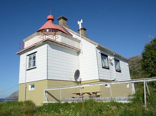

Torsvåg Light, Karlsøy
Norwegian Lighthouse Association photo by Roger
Karlsøy Municipality Lighthouses

Ringvassøya Area Lighthouses
Eggeløysa
Date unknown. Active; focal plane 20 m (66 ft); flash every 5 s, white, red or green depending on direction. 13.5 m (44 ft) skeletal tower with lantern and gallery. No photo available but Bing has a satellite view. Located on a skerry off the south end of Store Hattøy, an island northwest of Rebbenesøya. Accessible only by boat. Site open, tower closed. NF-875500; Admiralty L3610; NGA 13352.
Andamsmulen
Date unknown. Active; focal plane 10.5 m (34 ft); two flashes every 10 s, white, red or green depending on direction. 8 m (26 ft) concrete post with lantern and gallery. Lighthouse painted white, lantern roof red. No photo available but Bing has an indistinct satellite view. Located on a skerry just off the northwestern tip of Andammen island. Accessible only by boat. Site open, tower closed. NF-875800; Admiralty L3610.4; NGA 13356.
Ormholmen
Date unknown. Active; focal plane 32.5 m (107 ft); two flashes every 10 s, white, red or green depending on direction. 9 m (30 ft) square skeletal tower with enclosed upper portion, lantern and gallery. Lighthouse painted white, lantern roof red. No photo available but Bing has a satellite view. Located on the northeastern tip of Grøtøy. Site status unknown. NF-877800; Admiralty L3616; NGA 13368.
Helgøya (Helgøy)
Date unknown. Active; focal plane 6 m (20 ft); white, red or green light depending on direction, 3 s on, 3 s off. 6.5 m (21 ft) square wood tower with lantern and gallery. Lighthouse painted white, lantern roof red. No photo available but Google has a satellite view. Located on Skjåholmskjæret, a skerry off the southern tip of Helgøy, an island lying north of Ringvassøya. Accessible only by boat. Site open, tower closed. NF-885500; Admiralty L3668; NGA 13480.
Dåfjorden (Bukkholmen)
Date unknown. Active; focal plane 7.5 m (25 ft); white, red or green light depending on direction, 3 s on, 3 s off. 6 m (20 ft) square wood tower with lantern and gallery. Lighthouse painted white, lantern roof red. No photo available but Google has a very distant street view and Bing has an indistinct satellite view. Located on Bukkholmen, a small island in the Dåfjord, a wedge-shaped inlet on the north side of Ringvassøya. Accessible only by boat. Site open, tower closed. NF-886000; Admiralty L3670; NGA 13484.
Brennes
Date unknown. Active; focal plane 7.5 m (25 ft); flash every 5 s, white, red or green depending on direction. 6.5 m (21 ft) square wood tower with lantern and gallery. Lighthouse painted white, lantern roof red. Trabas has Capt. Peter's photo and Bing has a distant satellite view. NGA misspells the name as Bremmes. Located on the northeastern coast of Ringvassøya. Accessible only by boat. Site open, tower closed. NF-886500; Admiralty L3672; NGA 13488.
* Langsundet (Skattøra, Skattoyra) (2)
2017 (?). Active; focal plane 6.5 m (21 ft); white, red or green light depending on direction, occulting once every 6 s. 6 m (20 ft) round fiberglass tower with lantern, colored white with two black horizontal bands and a red roof. Google has an August 2018 street view of the new light. This light replaced a square wood tower with lantern and gallery; Trabas has Capt. Peter's closeup photo, Werner Röder has a May 2016 photo, and Google has a very distant satellite view. The Langsundet (Long Sound) is a narrow passage between the islands of Ringvassøya and Reinøya. Located on a very sharp point of land projecting from Ringvassøya about 4 km (2.5 mi) northeast of Hansnes. Site aopears open, tower closed. NF-884900; Admiralty L3664; NGA 13476.
Gamnes (Gamneset)
Date unknown. Active; focal plane 15 m (49 ft); white, red or green light depending on direction, occulting twice every 8 s. 6 m (20 ft) square wood tower with lantern and gallery. Lighthouse painted white, lantern roof red. Trabas has Capt. Peter's photo and Bing has a distant satellite view. The Admiralty misspells the name as Gammneset. Located on the northeastern coast of Ringvassøya. Accessible only by boat. Site open, tower closed. NF-884800; Admiralty L3660; NGA 13472.

Vannøy Area Lighthouses
* Karlsøy
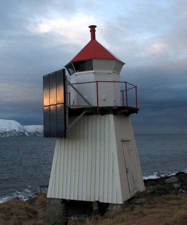
Date unknown. Active; focal plane 15 m (49 ft); white, red or green light depending on direction, occulting twice every 8 s. 6 m (20 ft) square wood tower with lantern and gallery. Lighthouse painted white, lantern roof red. A photo by Matilde Martínez is at right, the Degree Confluence Project has a photo by Hermann Grebner and Bing has a distant satellite view. Located on a promontory at the southeastern tip of Karlsøya, about 3 km (2 mi) southeast of the town of Karlsøy. Site open, tower closed. NF-904200; Admiralty L3720; NGA 13592.
Karlsøy Light
Karlsøy Light, Karlsøy, August 2009
Flickr Creative Commons photo by Matilde Martínez
* Vannøyklubben
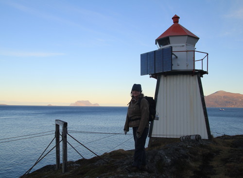
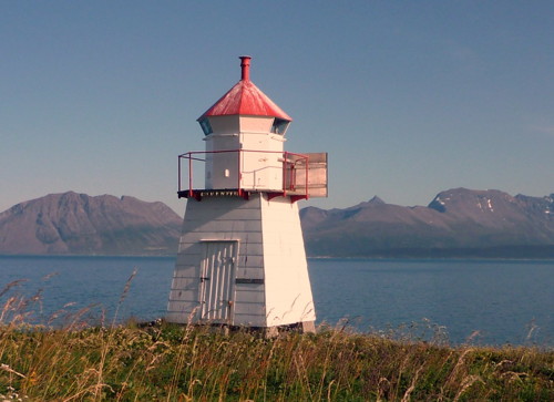
Date unknown. Active; focal plane 10 m (33 ft); white, red or green light depending on direction, occulting once every 6 s. 6.5 m (21 ft) square wood tower with lantern and gallery. Lighthouse painted white, lantern roof red. Helmut Wilhelm's closeup photo is at right, Google has a closeup street view, and Bing has a satellite view. Located beside the coastal highway on a promontory on the southwest coast of Vannøy. Site open, tower closed. NF-887000; Admiralty L3674; NGA 13492.
* Skarvbarden
Date unknown. Active; focal plane 9 m (30 ft); white, red or green light depending on direction, occulting twice every 8 s. 7 m (23 ft) lantern mounted on a platform supported by piles. Lantern painted white with a red roof, piles painted black. No closeup photo available; Google has a distant street view but only a fuzzy satellite view. Located on a breakwater pier at the southern entrance to Torsvåg harbor. Accessible by walking the pier. Site open, tower closed. NF-887500; Admiralty L3678; NGA 13496.
* Torsvåg
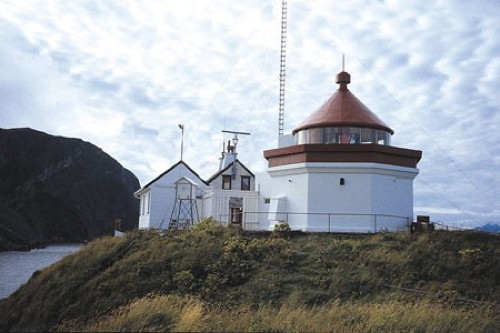
1916. Active; focal plane 32 m (105 ft); white, red or green light depending on direction, occulting once every 6 s. 9 m (30 ft) square wood tower attached at the gable end of a 1-1/2 story wood keeper's house. Lighthouse painted white; lantern and gallery painted red. A photo is at the top of this page, a 2012 photo is available, E. Dreier has a photo of a reindeer herd at the lighthouse, Morten Dreier has a nice 2009 photo, and Google has a street view and a satellite view. This light marks the entrance to the Hamrefjord. Starting in 1933 this was a staffed weather station; the weather observations are now made automatically. The light station is now managed by Torsvåg Havfiske, a company that offers sea fishing as well as accommodations at the lighthouse. Located atop a small island off the northwestern tip of Vannøy; the station is connected to Vannøy by a short causeway. Site open, tower status unknown. Site manager: Torsvåg Havfiske . ARLHS NOR-251; NF-888000; Admiralty L3682; NGA 13504.
Burøynakken
Date unknown. Active; focal plane 27 m (89 ft); two flashes every 10 s, white, red or green depending on direction. 10.5 m (34 ft) concrete post with lantern and gallery. Lighthouse painted white, lantern roof red. No photo available but Bing has an indistinct satellite view. Located at the northern tip of Burøy, an island off the northeast side of Vannøy. Accessible only by boat. Site open, tower closed. NF-888800; Admiralty L3688; NGA 13516.
Vannøyklubben Light
Vannøyklubben Light, Vannøy, March 2006
ex-Panoramio photo copyright Helmut Wilhelm; used by permission
Burøysundet (Burøysund)
Date unknown. Active; focal plane 5 m (17 ft); white, red or green light depending on direction, 3 s on, 3 s off. 4.5 m (15 ft) lantern mounted on a stone or concrete base. Lantern painted white with a red roof. No closeup photo available but Google has a distant street view across the fjord and Bing has a satellite view. Located on the southern tip of Burøy, marking the entrance to the Burøysund, the narrow strait between Burøy and Vannøy. Accessible only by boat. Site open, tower closed. NF-889000; Admiralty L3690; NGA 13524.
Store Skorøya
Date unknown. Active; focal plane 13 m (43 ft); two white flashes every 10 s, white, red or green depending on direction. 6 m (20 ft) square wood tower with lantern and gallery. Lighthouse painted white, lantern roof red. No photo available but Bing has a satellite view. Located on the southern tip of Store Skorøya, an island off the southeast coast of Vannøy. Accessible only by boat. Site open, tower closed. NF-900400; Admiralty L3700; NGA 13544.
Fugløykalven
1916. Active; focal plane 41 m (135 ft); white, red or green light depending on direction, occulting twice every 8 s. 8.5 m (28 ft) octagonal cylindrical stone tower bearing a large lantern and gallery. The original 2nd order Fresnel lens remains in use; it displays 19 colored sectors, the largest number of any Norwegian light. Lighthouse painted white, lantern red. Sibling of Sula Fyr, Trondheim. There is a small 1-1/2 story keeper's house and one or two service buildings, all clinging to the top of a small island; ropes were needed to haul supplies up from the boathouse. A Culture Ministry photo is at right, a similar photo and a view from the sea are available, and Bing has a satellite view of the station. This was considered one of the most isolated and difficult assignments of all Norwegian light stations. Located on a small island off the northwestern tip of Fugløy (Fugløykalven means "calf of Fugløy"). Accessible only by boat, and landing is difficult. Site and tower closed. ARLHS NOR-091; NF-900000; Admiralty L3692; NGA 13520.
Fugløykalven Fyr
Fugløykalven Light, Karlsøy
Norwegian Culture Ministry Creative Commons photo by Danckert Monrad-Krohn

Northeastern Troms Lighthouses

Lyngen Lighthouses
Sørlenangen
Date unknown. Active; focal plane 7 m (23 ft); white, red or green light depending on direction, occulting twice every 8 s. 6 m (20 ft) square wood tower with lantern and gallery. Lighthouse painted white, lantern roof red. Trabas has Capt. Peter's photo and Bing has a distant satellite view. Located at the tip of a promontory projecting into the Ullsfjord north of Ravik. May be accessible only by boat. Site open, tower closed. NF-903200; Admiralty L3714; NGA 13572.
* Nordlenangen
Date unknown. Active; focal plane 5 m (17 ft); white, red or green light depending on direction, occulting once every 6 s. 4 m (13 ft) concrete post with lantern and gallery. Lighthouse is white, lantern roof red. Trabas has Capt. Peter's closeup photo but Google has a only a very distant street view and a distant satellite view. Located at the elbow of the north breakwater at Nordlenangen. Accessible by walking the pier. Site open, tower closed. NF-903400; Admiralty L3716; NGA 13580.
Lyngstuva
Date unknown. Active; focal plane 29 m (95 ft); flash every 5 s, white, red or green depending on direction. 6 m (20 ft) square wood tower with lantern and gallery. Lighthouse painted white, lantern roof red. Eivind Rinde's 2011 photo is at right, Trabas has Siering's photo and Bing has a distant satellite view. Located on a promontory overlooking the Ullsfjord about 8 km (5 mi) north of Nordlenangen. Site open, tower closed. NF-904000; Admiralty L3718; NGA 13588.
#Kvitbergskjær (1)
Date unknown. Inactive since 2013 and later removed. This was a 5 m (17 ft)) square wood tower with lantern and gallery. Tower painted gray, lantern white with a red roof. Google has a distant satellite view of the location. The light was replaced by a post light (focal plane 6 m (20 ft); green flash every 3 s). Formerly located on a skerry in the Lyngenfjord off Kvitberg. Accessible only by boat. Site open. ex-Admiralty L3745; ex-NGA 13620. Active light: NF-906400; Admiralty L3746.
Nordtasholmen (Ytre Nortasholmen)
Date unknown (station established 1911). Active; focal plane 8 m (26 ft); flash every 5 s, white, red or green depending on direction. 7 m (23 ft) square wood tower with lantern and gallery. Lighthouse painted white, lantern roof red. Trabas has Siering's photo and Google has an indistinct satellite view. Located on a small island in the Lyngenfjord off Lyngseidet. Accessible only by boat. Site open, tower closed. NF-906600; Admiralty L3748; NGA 13624.
Lyngstuva Light
Lyngstuva Light, Lyngen, October 2011
ex-Panoramio photo copyright Eivind Rinde; used by permission

Storfjord Lighthouse
Salmenes
Date unknown. Active; focal plane 7 m (23 ft); white, red or green light depending on direction, occulting once every 6 s. 6 m (20 ft) square wood tower with lantern and gallery. Lighthouse painted white, lantern roof red. Trabas has Capt. Peter's closeup photo and Google has a distant satellite view. Located on a promontory on the east side of the Storfjord, an upper branch of the Lyngenfjord. Site open, tower closed. NF-907200; Admiralty L3754; NGA 13636.

Kåfjord Lighthouses
Mandalsklubben
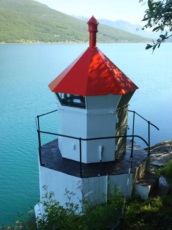
Date unknown. Active; focal plane 5 m (17 ft); white, red or green light depending on direction, occulting twice every 8 s. 4.5 m (15 ft) hexagonal concrete tower with lantern and gallery. Trabas has Capt. Peter's photo (also seen at right) but the light is not seen in Google's satellite view. Located at the foot of a promontory on the south side of the Kåfjord near Samuelsberg. Site status unknown, but a stairway down from the E6 highway probably leads to this light. NF-906000; Admiralty L3742; NGA 13640.
* Pertenga
Date unknown. Active; focal plane 6.5 m (21 ft); white, red or green light depending on direction, occulting once every 6 s. 6 m (20 ft) lantern on a platform supported by piles. Lantern painted white with a red roof. Trabas has Capt. Peter's photo, Google has a closeup street view, and Bing has a satellite view. Located next to the E6 highway on the north side of the upper Kåfjord at Pertenga. Site open, tower closed. NF-906200; Admiralty L3744; NGA 13644.

Skjervøy Lighthouses
Hylla
Date unknown. Active; focal plane 20.5 m (67 ft); flash every 5 s, white, red or green depending on direction. 6.5 m (21 ft) lantern on a platform supported by piles. Lantern painted white with a red roof. No photo available and shadow conceals the light in Bing's satellite view. Located at the northern tip of Arnøy. Site status unknown. NF-913000; Admiralty L3792; NGA 13728.
Nordre Lauksund
Date unknown. Active; focal plane 7 m (23 ft); white, red or green light depending on direction, occulting once every 6 s. 7 m (23 ft) round concrete tower with lantern and gallery. Lighthouse painted white, lantern roof red. Google has a street view and Bing has a distant satellite view. Located on the west side of the Lauksund, the narrow passage between Arnøy and Laukøy, about 4 km (2.5 mi) north of Lauksletta. Site status unknown. NF-912500; Admiralty L3790; NGA 13724.

Mandalsklubben Light, Kåfjord
photo copyright Capt. Peter Mosselberger; used by permission
Søre Lauksund
Date unknown. Active; focal plane 6.5 m (21 ft); white, red or green light depending on direction, occulting twice every 8 s. 6 m (20 ft) lantern on a platform supported by piles. Lantern painted white with a red roof. Google has a street view and Bing has a satellite view. Located on the west side of the Lauksund about 3 km (2 mi) south of Lauksletta. Site status unknown. NF-912400; Admiralty L3788; NGA 13720.
Kågsund
Date unknown (station established 1898). Active; focal plane 10 m (33 ft); white, red or green light depending on direction, occulting once every 6 s. 5 m (17 ft) concrete post light with lantern and gallery. Lighthouse painted white, lantern roof red. Google has the closeup street view seen at right, Trabas has Siering's photo, and Bing has a satellite view. Located on the southeastern tip of Arnøya. Accessible only by boat. Site open, tower closed. NF-908000; Admiralty L3756; NGA 13656.
Arnøya (Arnøy)
Date unknown. Active; focal plane 7 m (23 ft); white, red or green light depending on direction, occulting twice every 8 s. 6.5 m (21 ft) skeletal tower with lantern and gallery. Lantern painted white with a red roof. Trabas has Siering's photo, Google has a street view, and Bing has a satellite view. Located at the tip of Haugnes, a promontory on the south coast of Arnøy. Site status unknown. NF-904500; Admiralty L3724; NGA 13596.
Maursund
Date unknown. Active; focal plane 6.5 m (21 ft); white, red or green light depending on direction, 3 s on, 3 s off. 6 m (20 ft) square tower with lantern and gallery. Lighthouse painted white, lantern roof red. Trabas has Capt. Peter's photo and Google has a distant satellite view and a very distant street view across the fjord. Located on the south side of the entrance to the Maursund, the passage between the islands of Kågen and Hamneide. Site status unknown. NF-905400; Admiralty L3730; NGA 13608.

Kågsund Light, Skjervøy, June 2022
Google Maps street view

Kvænangen Lighthouses
* Kvænangstraumen
Date unknown. Active; focal plane 5 m (17 ft); white, red or green light depending on direction, occulting once every 6 s. 6 m (20 ft) skeletal tower with lantern and gallery. Lantern painted white with a red roof. Trabas has Capt. Peter's photo, Google has a distant street view, and Bing has a satellite view. The Kvænangstraumen is a narrow strait connecting the Båderfjord and Sørfjord about 25 km (15 mi) south of Burfjord. The E6 highway crosses the strait about 200 m (220 yd) south of the light. Located on the west side of the entrance to the strait from the Båderfjord. Site open, tower closed. NF-911400; Admiralty L3784; NGA 13716.
Storengneset
Date unknown. Active; focal plane 11.5 m (38 ft); white, red or green light depending on direction, 3 s on, 3 s off. 9 m (30 ft) square skeletal tower, upper portion enclosed, with lantern and gallery. Lighthouse painted white, lantern roof red. Trabas has Capt. Peter's photo and Bing has an indistinct satellite view. Located on a promontory at the junction of the Burfjord and the Jøkelfjord. Site status unknown. NF-911000; Admiralty L3780; NGA 13700.
Jøkelfjord
Date unknown. Active; focal plane 10 m (33 ft); white, red or green light depending on direction, occulting once every 6 s. 10 m (33 ft) concrete post with lantern and gallery. Lighthouse painted white, lantern roof red. Trabas has Capt. Peter's closeup photo but the light is not seen in Google's very distant satellite view. Located on Slettneset, a headland on the south side of the Jøkelfjord. Site status unknown. NF-911800; Admiralty L3787; NGA 13704.

Information available on lost lighthouses:

Notable faux lighthouses:

Adjoining pages: North: Hammerfest Area | South: Tromsø Area

Return to the Lighthouse Directory index | Ratings key

Posted August 3, 2006. Checked and revised September 25, 2023. Lighthouses: 33. Site copyright 2023 Russ Rowlett and the University of North Carolina at Chapel Hill.