Lighthouses of Norway: Tromsø Area

The Kingdom of Norway (Norge in Norwegian) is one of the world's most maritime nations. The country is long and narrow, with drowned valleys called fjords that bring the sea far inland in most regions. The mainland coast is estimated to be 2650 km (1650 mi) long and when all the islands and minor indentations are counted the total coastline approaches an astonishing 60,000 km (37,500 mi), long enough the go around the world one and a half times. With such a lengthy and rocky shore it's not surprising that Norway has a large number of lighthouses.

Norway is divided into counties (fylker) and the counties are divided into townships (kommuner). This page lists lighthouses of the Tromsø township in the former (and future) Troms County on the northern coast of Norway. This entire county is well north of the Arctic Circle. Nonetheless it is well populated with Tromsø being its largest port.

In 2020 Troms and Finnmark Counties were merged to form Troms og Finnmark County. This merger was not popular and it proved unworkable due to the large area of the merged county. In June 2022 parliament decided to reverse the merger effective 1 January 2024.

In Norwegian a lighthouse is a fyrtårn (fire tower) or simply a fyr; a fyrlykt is a beacon and a lyktehus is a lantern. Øy is an island, holmen is an islet, skjær is a skerry (a tiny island or rocky reef), sund is a strait (often between an island and the mainland), bukt is a bay, nes is a headland, and havn is a harbor.

Aids to navigation in Norway are maintained by the Kystverket (Coast Directorate), an agency of the Ministry of Transport and Communications.

ARLHS numbers are from the ARLHS World List of Lights. NF numbers are from the Norsk Fyrliste. Admiralty numbers are from volume L of the Admiralty List of Lights & Fog Signals. U.S. NGA List numbers are from Publication 115.

General Sources
Norsk Fyrhistorisk Forening
News and photos from the Norwegian Lighthouse Association.
Lighthouse Pages from Anke and Jens - Norway
Excellent photos of more than 60 Norwegian lighthouses.
Online List of Lights - Norway
Photos by various photographers posted by Alexander Trabas. Most of the photos for this area are by Capt. Peter Mosselberger (Capt. Peter), Rainer Arndt, or Arno Siering.
Norway's Fjorden and Lighthouses
Photos taken by Charles W. Bash on a 2010 cruise from Bergen to North Cape.
Lighthouses in Troms og Finnmark
Photos by various photographers available from Wikimedia.
Norwegische Leuchttürme auf historischen Postkarten
Historic postcard images posted by Klaus Huelse.
Liste over Norske Fyr
From Wikipedia, a handy list of Norwegian light stations with their dates of establishment.
Norsk Fyrliste
The official Norwegian light list can be downloaded in .pdf format.
GPSNavigationCharts
Navigation chart information for this area.
Navionics Charts
Navigation chart for Troms.

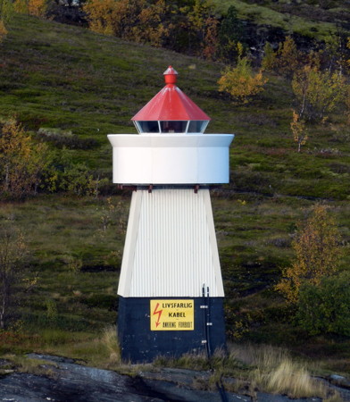
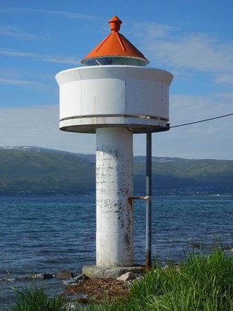
Ryøystraumen Fyr
Ryøystraumen Light, Tromsø, September 2011
photo copyright Michael Boucher; used by permission

Southern Kvaløya Area Lighthouses
The lights in this group are on small islands, mostly off the coast of Kvaløya, a large island (the fifth largest Norwegian island) between Tromsø and the Norwegian Sea. The island's permanent population is about 10,000. The Sandnessund Bridge connects Kvaløya to Tromsø.

Skarvhalsen
Date unknown. Active; focal plane 11 m (36 ft); flash every 5 s, white, red or green depending on direction. 7 m (23 ft) concrete post with lantern and gallery. Lighthouse painted white, lantern roof red. No photo available but Google has a distant satellite view. Located on the west side of Edøy, marking the north side of the entrance to the Malangenfjord, which separates Kvaløya from the island of Senja. Accessible only by boat. Site open, tower closed. NF-863700; Admiralty L3555.4; NGA 13192.
* #[Hillesøy (Lille Lyngøy) (1)]
Date unknown (station established 1906). Replaced. This was a 4.5 m (16 ft) round lantern mounted on a concrete base. Lantern painted white with a red roof. No photo available but Google has a distant satellite view. Trabas has Capt. Peter's photo of the new light (focal plane 5 m (17 ft); red flash every 3 s) on a mast. Not to be confused with the historic Lille Lyngøy light station (see below). Located at the tip of a promontory on the west side of the entrance to the harbor of Hillesøy. The island is accessible from Kvaløya over a series of bridges. Site open, and it appears that visitors can walk up a stairway to the lantern. NF-864150; Admiralty L3557; ex-NGA 13216.
Skarvskjær (2)
Date unknown. Active; focal plane 6.5 m (21 ft); white, red or green light depending on direction, 2 s on, 2 s off. 6 m (20 ft) lantern on a platform supported by piles. Lighthouse is white; lantern roof is red. Trabas has Capt. Peter's photo and Google has a satellite view. Located on a skerry off the south coast of Hillesøy, a small island off the southwestern end of Kvaløya. Accessible only by boat. Site open, tower closed. NF-863900; Admiralty L3556; NGA 13212.
Værholmen
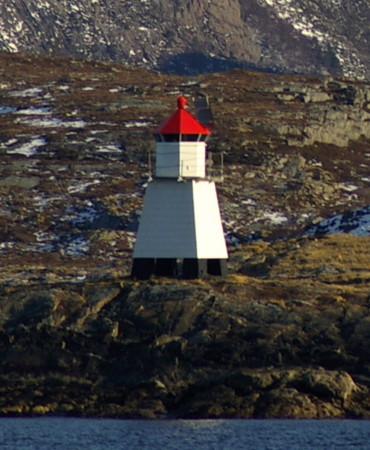
Date unknown. Active; focal plane 33 m (108 ft); flash every 5 s, white, red or green depending on direction. 6 m (20 ft) square skeletal tower with lantern and gallery, mostly enclosed by siding. Lighthouse painted white, lantern roof red. Trabas has Capt. Peter's photo (also seen at right), P.H. Hesse has a distant view, another distant photo is available, and Google has a distant satellite view. Located on an islet off the north coast of Hillesøy. Accessible only by boat. Site open, tower closed. NF-866300; Admiralty L3562; NGA 13240.
Sommarøy
Date unknown (station established 1903). Active; focal plane 8.5 m (28 ft); white, red or green light depending on direction, 3 s on, 3 s off. 6 m (20 ft) square skeletal tower with lantern and gallery, mostly enclosed by siding. Lighthouse painted white, lantern roof red. Trabas has Siering's photo, a distant view is available, and Google has a satellite view. Located on an islet off the north coast of Sommarøy. Accessible only by boat. Site open, tower closed. NF-866000; Admiralty L3560; NGA 13236.
Vasstrand
Date unknown. Active; focal plane 8.5 m (28 ft); white, red or green light depending on direction, occulting once every 6 s. 6 m (20 ft) square skeletal tower with lantern and gallery, enclosed by siding. Lighthouse painted white, lantern roof red. Stian Paulsen has a 2019 photo and Google has a satellite view. Located on a promontory on the west side of Kvaløya opposite Tussøy. Site open, tower closed. NF-867000; Admiralty L3566; NGA 13244.
Sessøysund (Tennskjær)
Date unknown. Active; focal plane 9.5 m (31 ft); white, red or green light, depending on direction, occulting once every 6 s. 6 m (20 ft) square tower with lantern and gallery, enclosed by siding. Lighthouse painted white, lantern roof red. No photo available but Google has a distant satellite view. Located on a skerry in the entrance to the Sessøysund, an inlet on the central west coast of Kvaløya. Accessible only by boat. Site open, tower closed. NF-868000; Admiralty L3570; NGA 13252.

Vaerholmen Light, Kvaløya, about 2015
photo copyright Capt. Peter Mosselberger; used by permission
Bjørnøy
Date unknown. Active; focal plane 9 m (30 ft); white, red or green light depending on direction, occulting twice every 8 s. 6.5 m (21 ft) square tower with lantern and gallery, enclosed by siding. Lighthouse painted white, lantern roof red. Trabas has Erich Hartmann's photo and Google has a satellite view. Located at the northeastern tip of Bjørnøy, an island about 8 km (5 mi) off the west coast of Kvaløya. Accessible only by boat. Site open, tower closed. NF-868500; Admiralty L3572; NGA 13256.

Northern Kvaløya and Southern Ringvassøya Area Lighthouses
Auvær
Date unknown. Active; focal plane 29 m (95 ft); two white flashes every 10 s. 9 m (30 ft) square wood skeletal tower with lantern, gallery, and enclosed upper portion. Skeletal portion painted black, upper portion and lantern white, lantern roof red. A photo (halfway down the page) is available and Google has a satellite view. Located atop a small island about 32 km (20 mi) west of the entrance to the Vengsøyfjord. Accessible only by boat. Site open, tower closed. NF-869500; Admiralty L3578; NGA 13264.
Store Ganholmen
Date unknown. Active; focal plane 17 m (56 ft); white flash every 5 s. 6 m (20 ft) square tower with lantern and gallery, enclosed by wood siding. Lighthouse painted white, lantern roof red. Trabas has Erich Hartmann's distant view and Bing has a satellite view. Located atop a small island off the entrance to the Vengsøyfjord. Accessible only by boat. Site open, tower closed. NF-870000; Admiralty L3582; NGA 13268.
Lille Lyngøy (2?)
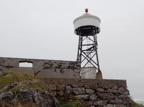
Date unknown (station established 1906). Active; focal plane 27.5 m (90 ft); two flashes every 10 s, white, red or green depending on direction. 11.5 m (38 ft) square skeletal tower with lantern and gallery standing on the foundations of the historic lighthouse. The photo at right is from a Facebook video posted by the Cultural Office of Tromsø Kommune, Trabas has Arndt's distant view, and Bing has a satellite view. The original lighthouse was a 1-1/2 story keeper's house with a lantern at one end; after being deactivated in 1952 it was sold and removed in 1953. Foundation ruins survive. This present modest light is a landfall light for Tromsø. Located on a small island about 15 km (9 mi) northwest of the northern tip of Kvaløya. Accessible only by boat. Site status unknown. NF-872900; Admiralty L3592; NGA 13300.

Lille Lyngøy Light, Tromsø, September 2016
Facebook video frame by Kulturminner Tromsø kommune
Kvitholmen (Simabakleia) Range Front
Date unknown. Active; focal plane 15 m (49 ft); white flash every 3 s. 6.5 m (21 ft) lantern on a platform supported by piles. Lantern painted white, roof red. Trabas has Arndt's distant view and Bing has a satellite view. Located on Kvitholmen, a small island northwest of Store Lyngøy. Site open, tower closed. NF-873200; Admiralty L3594; NGA 13304.
Kvitholmen (Simabakleia, Store Lyngøy) Range Rear
Date unknown. Active; focal plane 28 m (92 ft); white, red or green light depending on direction, 3 s on, 3 s off. 6 m (20 ft) square tower with lantern and gallery, enclosed by wood siding. Lighthouse painted white, lantern roof red. Trabas has Arndt's distant view and Bing has a satellite view. Located on the heights of Store Lyngøy 594 m (3/8 mi) southeast of the front light. Site open, tower closed. NF-873100; Admiralty L3594.1; NGA 13308.
 
Klokkerholmen
Date unknown. Active; focal plane 10.5 m (34 ft); white, red or green light depending on direction, 3 s on, 3 s off. 6 m (20 ft) square tower with lantern and gallery, enclosed by wood siding. Lighthouse painted white, lantern roof red. Joachim Probst's photo is at right, Trabas has Arndt's distant view and Bing has a satellite view. Located on a promontory on the west coast of the large island of Ringvassøya. Site open, tower closed. NF-874000; Admiralty L3598; NGA 13316.
Hysholmen
Date unknown. Active; focal plane 13 m (46 ft); white, red or green light depending on direction, occulting twice every 8 s. 6 m (20 ft) square tower with lantern and gallery, enclosed by wood siding. Lighthouse painted white, lantern roof red. No photo available but Bing has a satellite view. Located on a skerry in the Sandøyfjord, the passage between the island of Sandøya and Ringvassøya. Site open, tower closed. NF-874500; Admiralty L3604; NGA 13328.
Sørstabben
Date unknown. Active; focal plane 7.5 m (25 ft); flash every 5 s, white, red or green depending on direction. 8.5 m (28 ft) lantern mounted on a platform supported by piles. Lantern painted white with a red roof. No photo available but Bing has a satellite view. Located on a skerry in the Sandøyfjord off the east coast of Sandøya. Accessible only by boat. Site open, tower closed. NF-874800; Admiralty L3606; NGA 13336.
Styrsøy
Date unknown. Active; focal plane 7.5 m (25 ft); white, red or green light depending on direction, occulting three times every 12 s. 9 m (30 ft) lantern and gallery mounted on a tripod. Lantern painted white with a red roof. A very distant view (upper center, closer than the three skerries) is available, the county has a distant street view, and Bing has a distant satellite view. Located in the Sandøyfjord near Løksfjord, off the southwest coast of Rebbenesøya. Accessible only by boat. Site open, tower closed. NF-875000; Admiralty L3608; NGA 13340.
Klokkerholmen Light
Klokkerholmen Light, Ringvassøya, March 2011
Flickr Creative Commons photo by Joachim Probst
Teistholmen (Skarsfjorden)
Date unknown. Active; focal plane 7 m (23 ft); white, red or green light depending on direction, occulting twice every 8 s. 5 m (17 ft) square wood tower with lantern and gallery. Lighthouse painted white, lantern roof red. A photo is available (last photo on the page), and Bing has a distant satellite view. Located on the north side of the entrance to the Skarsfjord, about 3 km (2 mi) west of Stordal on the west coast of the large island of Ringvassøya. Accessible only by boat. Site open, tower closed. NF-876200; Admiralty L3612; NGA 13360.

Balsfjord Area Lighthouses
The Balsfjord extends for 57 km (35 mi) south from the Tromsø area.

Rystraumen (Ryøystraumen, Storstraumen)
Date unknown. Active; focal plane 9.5 m (31 ft); white, red or green light depending on direction, occulting twice every 8 s. 7.5 m (25 ft) square skeletal tower, covered by siding, with lantern and gallery. Lighthouse painted white, lantern roof red. Trabas has Michael Boucher's photo (also seen at the top of this page), Bash has a photo, and Bing has a satellite view. Located on the south coast of Kvaløya, marking a narrow passage between that island and the smaller island of Ryøy about 4 km (2.5 mi) west of the mouth of the Balsfjord. Site open, tower closed. NF-879000; Admiralty L3626; NGA 13392.
* Balsnes (Balsnesodden)
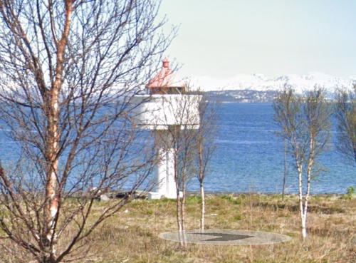
Date unknown. Active; focal plane 7 m (23 ft); white, red or green light depending on direction, occulting once every 6 s. 6 m (20 ft) concrete post light with lantern and gallery. Lighthouse painted white, lantern roof red. Google has the street view seen at right, Trabas has Capt. Peter's closeup photo, Bash has a view from the fjord, and Bing has a satellite view. Located at the tip of a promontory at the entrance to the Balsfjord, about 10 km (6 mi) southwest of Tromsø. Site open, tower closed. NF-879100; Admiralty L3627; NGA 13396.

Balsnes Light, Tromsø, May 2019
Google Maps street view

Tromsø Area Lighthouses
Tromsø, the largest city of Norway's northern coast, is built on the east side of Tromsøya, an island in the Tromsøysund. The city has a population of nearly 80,000 and has an airport and a university.

Lanesgrunnen
Date unknown. Active; focal plane 11 m (36 ft); two white flashes every 5 s. 19 m (62 ft) concrete post with gallery. Lantern removed. Post painted with black and red horizontal bands; gallery painted white. Trabas has Capt. Peter's photo and Google has a satellite view. This is the first of a series of lights in the Sandnessund, the channel on the west side of Tromsøya, that had lanterns in the past. Located at the southern entrance to the Sandnessund. Accessible only by boat. Site open, tower closed. NF-880000; Admiralty L3631; NGA 13438.
Hansmark
Date unknown. Active; focal plane 6 m (20 ft); white, red or green light depending on direction, occulting once every 6 s. 8 m (26 ft) concrete post light with lantern and gallery. Lighthouse painted white, lantern roof red. Trabas has Capt. Peter's closeup photo (also seen at right) and Google has a street view and a satellite view. Located on the southwest coast of Tromsøya, about 3.2 km (2 mi) south of the Sandnessund Bridge. Site status unknown. NF-880100; Admiralty L3630; NGA 13440.
Grindøyskarven
Date unknown. Active; focal plane 10 m (33 ft); red flash every 3 s. 18 m (59 ft) concrete post with gallery. Lantern removed. Post painted red; gallery painted white. Trabas has Capt. Peter's photo and Google has an indistinct satellite view. Located on the west side of the channel between Tromsøya and Håkøya. Accessible only by boat. Site open, tower closed. NF-880200; Admiralty L3638; NGA 13441.
Vestre Skarvegrunnen
Date unknown. Active; focal plane 8 m (26 ft); white, red or green light depending on direction, 3 s on, 3 s off. 8.5 m (28 ft) concrete post with lantern and gallery. Post painted black gallery painted white, lantern roof red. Trabas has Capt. Peter's photo and Google has a satellite view. Located on the west side of the channel west of Tromsøya and northeast of Håkøya. Accessible only by boat. Site open, tower closed. NF-880400; Admiralty L3638.2; NGA 13441.5.
Steinen
Date unknown. Active; focal plane 10 m (33 ft); green light, 1 s on, 1 s off. 19.5 m (64 ft) concrete post with gallery. Lantern removed. Post painted green; gallery painted white. Trabas has Capt. Peter's photo and Google has a satellite view. Located on the east side of the channel off the Tromsø airport. Accessible only by boat. Site open, tower closed. NF-880500; Admiralty L3638.4; NGA 13442.
Erikgrunnen
Date unknown. Active; focal plane 11 m (36 ft); green light, 2 s on 2 s off. 17.5 m (57 ft) concrete post with gallery. Lantern removed. Post painted green; gallery painted white. Trabas has Capt. Peter's photo and Google has a satellite view. This light and the next one are on the south side of the Sandnessund Bridge, which connects Tromsø to Kvalsøya on the west. The two lights frame the channel for vessels approaching the bridge from the south. In Wikipedia's aerial photo of Sandnessund Bridge, this light is at the far right. Accessible only by boat. Site open, tower closed. NF-880900; Admiralty L3638.6; NGA 13443.

Hansmark Light, Tromsø, about 2015
photo copyright Capt. Peter Mosselberger; used by permission
Løknesgrunnen
Date unknown. Active; focal plane 11 m (36 ft); red light, 2 s on 2 s off. 17.5 m (57 ft) concrete post with gallery. Lantern removed. Lighthouse painted with red and white vertical stripes; gallery painted white. Trabas has Capt. Peter's photo and Google has a satellite view. Accessible only by boat. Site open, tower closed. NF-880800; Admiralty L3638.8; NGA 13442.5.
Sandnessundet Bru (Sandnessund Bridge)
Date unknown. Active; focal plane 7.5 m (25 ft); white, red or green light depending on direction, occulting once every 6 s. 7 m (23 ft) concrete post with lantern and gallery. Lighthouse painted white, lantern roof red. Trabas has Capt. Peter's photo but the bridge hides the light in Google's satellite view. Located on the west pier of the Sandnessund Bridge. Accessible only by boat. Site open, tower closed. NF-880902; Admiralty L3640.94.; NGA 13428.
Skognesgrunnen
Date unknown. Active; focal plane 9 m (30 ft); green light, 1 s on 1 s off. 17.5 m (57 ft) concrete post with gallery. Lantern removed. Post painted green, gallery painted white. This light is on the north side of the Sandnessund Bridge, which connects Tromsø to Kvalsøya. Trabas has Capt. Peter's photo and Google has a satellite view. In Wikipedia's aerial photo, the light is to the left of the bridge, farther from the camera. Accessible only by boat. Site open, tower closed. NF-881000; Admiralty L3641.2; NGA 13443.5.
Slettskjærgrunnen
Date unknown. Active; focal plane 9.5 m (31 ft); red light, 1 s on 1 s off. 17.5 m (57 ft) concrete post with gallery. Lantern removed. Post painted red, gallery painted white. This light is on the north side of the Sandnessund Bridge, which connects Tromsø to Kvalsøya. Trabas has Capt. Peter's photo and Google has a satellite view. In Wikipedia's aerial photo, the light is to the left of the bridge, closer to the camera. Accessible only by boat. Site open, tower closed. NF-881200; Admiralty L3641; NGA 13444.
Sandneset
Date unknown. Active; focal plane 10 m (33 ft); green light, 2 s on 2 s off. 17.5 m (57 ft) concrete post with gallery. Lantern removed. Post painted green, gallery painted white. Trabas has Capt. Peter's photo and Google has a satellite view. Located off the northwestern point of Tromsøya. Accessible only by boat. Site open, tower closed. NF-881300; Admiralty L3641.4; NGA 13444.5.
Nesland
Date unknown. Active; focal plane 6 m (20 ft); white, red or green light depending on direction, occulting twice every 8 s. 7 m (23 ft) concrete post with lantern and gallery. Lighthouse painted white, lantern roof red. Trabas has Capt. Peter's photo, Per Ivar Somby has a photo, and Google has a satellite view. Located off the Ringvegen at the northern tip of Tromsøya. Site status unknown. NF-881600; Admiralty L3642; NGA 13424.
Tønsnes
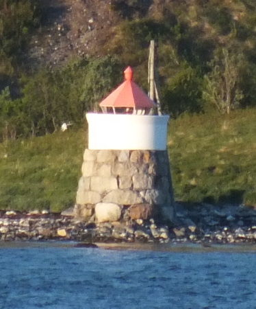
Date unknown. Active; focal plane 4 m (13 ft); white, red or green light depending on direction, occulting once every 6 s. 6 m (20 ft) lantern mounted on a stone cairn. Lantern painted white with a red roof. Siering's photo is at right, Trabas has Capt. Peter's photo, Geocaching.com has a photo, and Google has a satellite view. Located on a point of land projecting into the east side of the Tromsøysund about 5 km (3 mi) northeast of Tromsøya. Site status unknown (probably the light is on private property); there is a distant view from the Ringvegen. NF-882500; Admiralty L3643; NGA 13432.
Skallen
Date unknown. Active; focal plane 6 m (20 ft); white, red or green light depending on direction, occulting three times every 10 s. 7 m (23 ft) concrete post with lantern and gallery. Post painted red, lantern white with a red roof. Trabas has Arndt's photo, and Google has an indistinct satellite view. Located on an isolated rock in the Tromsøysund about 8 km (5 mi) northeast of Tromsøya. Site status unknown. NF-882600; Admiralty L3644; NGA 13436.

Tønsnes Light, Tromsø, June 2012
ex-Panoramio photo copyright Arno Siering; used by permission

Kvalsund Lighthouses
The Kvalsund is a narrow strait separating the island of Kvaløya from Ringvassøya.

Hansneset
Date unknown. Active; focal plane 6.5 m (22 ft); white, red or green light depending on direction, occulting twice every 8 s. 8 m (26 ft) square wood tower with lantern and gallery. Lighthouse painted white, lantern roof red. A Kystverket photo is at right, Trabas has Capt. Peter's closeup photo and Google has a street view and a distant satellite view. Located on a farm at the northeastern tip of Kvalsøya, marking the west side of the northern entrance to the Tromsøysund. Site status unknown, but the light can be seen from highway 863. NF-883000; Admiralty L3646; NGA 13448.
#Hellskoltan
Date unknown. Removed. 5 m (17 ft) lantern and gallery supported by tripod piles. Lantern is white with a red roof. Trabas has Capt. Peter's closeup photo and Bing has a fuzzy satellite view, but the light has disappeared from Google's satellite view. The light was replaced by two lights nearby, Hellskoltan North (NF-883107, Admiralty L3648.05) and Hellskoltan South (NF-883105, Admiralty L3647.5). No photos of the new lights are available as yet. Located on the east side of the Kvalsund near the line of the Kvalsund Tunnel. Accessible only by boat. Site open, tower closed. ex-NF-883300; ex-Admiralty L3648; ex-NGA 13452.
#Ytre Kårkvika (Meholmen)
Date unknown. Inactive at least since 2018. This was a 7 m (23 ft) lantern and gallery mounted on a stone cairn. Lantern painted white with a red roof. Trabas has Arndt's photo and Bing has an indistinct satellite view. The historic cairn remains but a 2023 photo shows that the lantern was removed. Located on Meholmen, a skerry in the Kvalsundet, the passage between Kvaløya and Ringvassøya. Accessible only by boat. Site open, tower closed. ex-NF-883500; ex-Admiralty L3649; ex-NGA 13320.
Hansneset Fyr
Hansneset Light, Tromsø, 2006
Kystverket photo (no longer online)

Grøtsund and Ullsfjord Lighthouses
* Vågnes
Date unknown. Active; focal plane 5 m (17 ft); white, red or green light depending on direction, occulting twice every 8 s. 6 m (20 ft) square wood tower with lantern and gallery. Lighthouse painted white, lantern roof red. Trabas has Capt. Peter's closeup photo, Truls Tiller has a spectacular nighttime photo, Ronald Bengt has a 2011 photo, Geocaching.com has a more distant view, and Google has a distant street view and a distant satellite view. Located on a point of land on the south side of the Grøtsund, the passage of the inland waterway leading northeast from Tromsø. Site apparently open, tower closed. NF-884000; Admiralty L3650; NGA 13456.
Kuberget
Date unknown. Active; focal plane 6 m (20 ft); flash every 5 s, white, red or green depending on direction. 6.5 m (21 ft) concrete post with lantern and gallery. Lighthouse painted white, lantern roof red. Trabas has Siering's distant view but the tower is inconspicuous in Google's distant satellite view. Located at the tip of a promontory on the west side of the Ullsfjord, which runs north to south east of Tromsø. Site status unknown. NF-902600; Admiralty L3711; NGA 13566.
Klubbskjær
Date unknown. Active; focal plane 6 m (20 ft); white, red or green light depending on direction, 3 s on, 3 s off. 6.5 m (21 ft) lantern and gallery mounted on a stone cairn. Lantern painted white with a red roof. Trabas has Capt. Peter's photo, Google has a very distant street view, and Bing has a satellite view. Located on the west side of the Sørfjord, a southern branch of the Ullsfjord, about 650 m (0.4 mi) off Sjurnes. Probably visible from the historic Sjurnes church, a well known attraction in this area. Accessible only by boat. Site status unknown. NF-902800; Admiralty L3712; NGA 13568.

Information available on lost lighthouses:

Notable faux lighthouses:

Adjoining pages: North: Northern Troms | South: Southern Troms

Return to the Lighthouse Directory index | Ratings key

Posted August 3, 2006. Checked and revised September 19, 2023. Lighthouses: 40. Site copyright 2023 Russ Rowlett and the University of North Carolina at Chapel Hill.