Lighthouses of Norway: Vadsø Area

The Kingdom of Norway (Norge in Norwegian) is one of the world's most maritime nations. The country is long and narrow, with drowned valleys called fjords that bring the sea far inland in most regions. The mainland coast is estimated to be 2650 km (1650 mi) long and when all the islands and minor indentations are counted the total coastline approaches an astonishing 60,000 km (37,500 mi), long enough the go around the world one and a half times. With such a lengthy and rocky shore it's not surprising that Norway has a large number of lighthouses.

This page lists lighthouses of the northernmost coast of Norway, including the eastern half of the former (and future) county of Finnmark. This entire region is well north of the Arctic Circle. Nonetheless it is fairly well populated, with several ports, the largest being Vardø on the Stavangerfjord not far from the Russian border. The region also includes part of the Nordkapp (North Cape) region, the "top of Europe," marked by Slettnes Fyr (shown below) and two other great lighthouses.

In 2020 Troms and Finnmark Counties were merged to form Troms og Finnmark County. This merger was not popular and it proved unworkable due to the large area of the merged county. In June 2022 parliament decided to reverse the merger effective 1 January 2024.

In Norwegian a lighthouse is a fyrtårn (fire tower) or simply a fyr; a fyrlykt is a beacon and a lyktehus is a lantern. Øy is an island, holmen is an islet, skjær is a skerry (a tiny island or rocky reef), sund is a strait (often between an island and the mainland), bukt is a bay, nes is a headland, and havn is a harbor.

Aids to navigation in Norway are maintained by the Kystverket (Coast Directorate), an agency of the Ministry of Transport and Communications.

ARLHS numbers are from the ARLHS World List of Lights. NF numbers are from the Norsk Fyrliste. Admiralty numbers are from volume L of the Admiralty List of Lights & Fog Signals. U.S. NGA List numbers are from Publication 115.

General Sources
Norsk Fyrhistorisk Forening
News and photos from the Norwegian Lighthouse Association.
Online List of Lights - Norway
Photos by various photographers posted by Alexander Trabas. Most of the photos for this area are by Capt. Peter Mosselberger (Capt. Peter), Michael Boucher, or Arno Siering.
Lighthouse Pages from Anke and Jens - Norway
Excellent photos of more than 60 Norwegian lighthouses.
Norway's Fjorden and Lighthouses
Photos taken by Charles W. Bash on a 2010 cruise from Bergen to North Cape.
Lighthouses in Finnmark
Photos available from Wikimedia.
Fyrstasjoner i Finnmark
Information on the major Finnmark lighthouses posted by the Kystverkmusea in Lindenes in southern Norway.
Liste over Norske Fyr
From Wikipedia, a handy list of Norwegian light stations with their dates of establishment.
Norwegische Leuchttürme auf historischen Postkarten
Historic postcard images posted by Klaus Huelse.
Norsk Fyrliste
The official Norwegian light list can be downloaded in six .pdf volumes.
GPSNavigationCharts
Navigation chart information for this area.
Navionics Charts
Navigation chart information for this area.


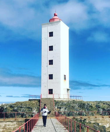
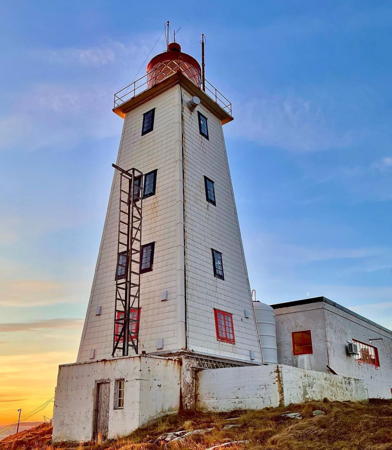
Vardø Light, Vardø, November 2022
Instagram photo by Alex Robins
Lebesby Lighthouses
Henrikholmen
Date unknown. Active; focal plane 28 m (92 ft); flash every 5 s, white, red or green depending on direction. 6.5 m (21 ft) square tower with lantern and gallery. Lighthouse painted white, lantern roof red. No photo available but Bing has a satellite view. Located on a small island off the west side of the Laksefjord. Accessible only by boat. Site status unknown. NF-951300; Admiralty L4086; NGA 14380.
* [Lebesby]
Date unknown (station established 1893). Active; focal plane 30 m (98 ft); white, red or green light depending on direction, 3 s on, 3 s off. 3 m (10 ft) lantern and snow screen. Lantern painted white with a red roof. Trabas has Capt. Peter's closeup photo, another photo is available, Google has a street view, and Bing has a satellite view. Located on Stamneset, a promontory on the east side of the Laksefjord about 7 km (4 mi) north of Lebesby. Accessible by road (highway 888). Site open, tower closed. NF-951900; Admiralty L4094; NGA 14392.
#Vardnes (2)
Date unknown. Replaced. This was a 7 m (23 ft) square tower with lantern and gallery. Lighthouse painted white, lantern roof red. No photo available but Bing has a satellite view. The new light (focal plane 20 m (66 ft); two red flashes every 10 s) is on a post Located on a sharp promontory on the east side of the Laksefjord at the entrance to the Vardnessund. Accessible only by boat. Site status unknown. Active light: NF-951502; Admiralty L4088; NGA 14384.
* Kjøllefjord (?)
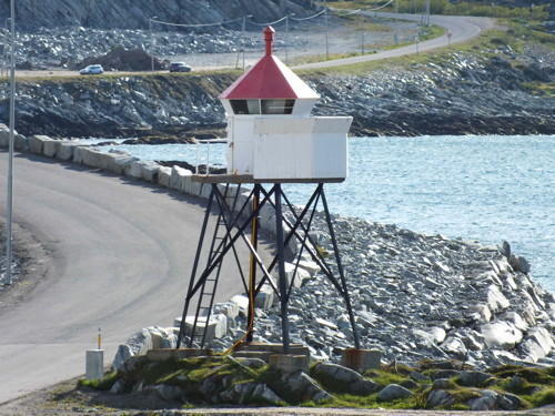
Date unknown. Inactive since 2022; may be removed.. 7 m (23 ft) square pyramidal skeletal tower with lantern and gallery. Lantern and snow screen painted white, lantern roof red. Arno Siering's photo is at right, Trabas has Capt. Peter's closeup photo, Google has a closeup 2010 street view, and Bing has a satellite view, but the tower is no longer seen in Google's satellite view. Located on Galgeneset, a gravel spit sheltering the harbor of Kjøllefjord on the west side of the Nordkinn Peninsula. Site open, tower closed. ex-NF-953300; ex-Admiralty L4108; NGA 14408.
Kjøllefjord Fyr
Kjøllefjord Light, Lebesby, June 2008
ex-Panoramio photo copyright Arno Siering; used by permission

Gamvik Lighthouses
These lighthouses are on the Nordkinn Peninsula (Nordkinnhalvøya), the northernmost extension of the Scandinavian mainland. Joined to the rest of Norway by a very narrow isthmus, the peninsula is accessible by road (highway 888).

*
Mehamn
Date unknown (station established 1893). Active; focal plane 11.5 m (38 ft); white, red or green light depending on direction, occulting once every 6 s. 6.5 m (21 ft) square skeletal tower with lantern and gallery. Lantern painted white with a red roof, skeletal legs painted black. Trabas has Capt. Peter's closeup photo, Kristiina Puumalainen has a photo, and Bing has a satellite view. Located on Hamnenes, a promontory marking the entrance to the traditional harbor of Mehamn, about 400 m (1/4 mi) west of the ferry terminal. Site open, tower closed. NF-955500; Admiralty L4120; NGA 14432.
**** Slettnes (Nordkapp)
1905. Active; focal plane 44 m (144 ft); one long (2.5 s) white flash every 20 s. 39 m (128 ft) round cast iron tower with lantern and gallery, painted red with two white horizontal bands. 1-1/2 story principal keeper's house and other light station buildings. Erik Stoel's photo appears at right, Trabas has Siering's closeup photo, Jens-Uwe Köhler has a 2007 photo of the station, a 2018 photo is available, the Kystverkmusea has a page for the lighthouse, and Google has a street view and a satellite view of the station. This is the easternmost of the three Nordkapp lighthouses, and it is often considered the North Cape Light, marking the "top" of Europe. Fruholmen Fyr (see the Hammerfest Area page) is about 500 m (0.4 mi) farther north, and the geographical North Cape is on the island of Magerøy, but Slettnes Fyr is the northernmost lighthouse on the mainland of Scandinavia. The lighthouse was heavily damaged during World War II but painstakingly restored after the war; it was reactivated in 1948. The station is managed by Gamvik Kommune as a tourist center and overnight accommodations are available in the station buildings June through August. Located on the Barents Sea coast about 1 km (0.6 mi) northwest of Gamvik. Site open; at least some of the buildings are open; tower open to guided tours during the summer season, mid-June through mid-August. Site manager: Slettnes Fyr . ARLHS NOR-215; NF-956500; Admiralty L4126; NGA 14444.
* [Gamvik Flintodden]
Date unknown (station established 1910). Active; focal plane 5.5 m (18 ft); white, red or green light depending on direction, occulting once every 6 s. 4 m (13 ft) lantern and snow screen. Lantern painted white with a red roof. Trabas has Capt. Peter's closeup photo, a view from the sea is available, Google has a distant street view, and Bing has a satellite view. Located on the point at the north side of the entrance to Gamvik harbor. Site open, tower closed. NF-957000; Admiralty L4128; NGA 14448.
* Gamvik Beritbukta (Kaveneset)
Date unknown. Active; focal plane 7.5 m (25 ft); white, red or green light depending on direction, occulting twice every 8 s. 7 m (23 ft) lantern and gallery mounted on four straightpiles. Lantern painted white with a red roof, piles painted black. Trabas has Capt. Peter's closeup photo, David Ash has a good photo, and Bing has a satellite view. Located on the south side of Gamvik harbor. Site open, tower closed. NF-957400; Admiralty L4132; NGA 14456.
Omgang (Omgangsneset, Tanafjord) (2)
Date unknown. Active; focal plane 16.5 m (54 ft); two flashes every 10 s, white, red or green depending on direction. 14 m (46 ft) round white fiberglass tower with lantern and gallery. Lantern painted white with a red roof. Trabas has Siering's view from the sea and Bing has a satellite view. A distant view is available of the original lighthouse, a square pyramidal skeletal tower with lantern and gallery. Located at the northeastern tip of the Nordfinn Peninsula, marking the entrance to the Tanafjord. NF-958200; Admiralty L4138; NGA 14472.

Slettnes Light, Gamvik, August 2022
Google Maps photo by Erik Stoel
Langfjordskjær
Date unknown. Active; focal plane 10 m (33 ft); two flashes every 10 s, white, red or green depending on direction. 9 m (29 ft) concrete post with lantern and gallery. Lighthouse painted white; lantern roof red. No photo available but Google has a satellite view. Located on a skerry in the middle of the entrance to the Langfjord, a western branch of the Tanafjord. Accessible only by boat. Site open, tower closed. NF-959300; Admiralty L4148; NGA 14488.

Deatnu-Tana (Upper Tanafjord) Lighthouses
Bergholmen
Date unknown. Active; focal plane 18 m (59 ft); flash every 5 s, white red or green depending on direction. 5 m (17 ft) lantern mounted on a square concrete base. Lighthouse painted white; lantern roof red. Trabas has Capt. Peter's view from the sea and Bing has a satellite view. Located on a skerry in the southwestern corner of the Tanafjord. Accessible only by boat. Site open, tower closed. NF-961200; Admiralty L4160; NGA 14520.
#Smalfjord (1)
Date unknown. Replaced. 8 m (26 ft) square skeletal tower with lantern and gallery. Lantern painted white with a red roof, skeletal legs painted black. No photo available. The light (focal plane 11 m (41 ft); red light occulting twice every 8 s) was moved to a post just offshore. Bing's satellite view confirms the removal of the original lighthouse. Located on the Smalfjordneset, a promontory near the head of the Tanafjord. Site open, tower closed. ex-NF-960800; ex-Admiralty L4158. Active light: NF-960904; Admiralty L4158.2; NGA 14512.

Bergholmen Light, Deatnu-Tana
photo copyright Capt. Peter Mosselberger; used by permission
Teltnes (Lavonjarg)
Date unknown. Active; focal plane 6 m (20 ft); red or green light depending on direction, occulting once every 6 s. 6 m (20 ft) square skeletal tower with lantern and gallery. Lantern painted white with a red roof, skeletal legs painted black. Trabas has Capt. Peter's photo and Bing has a distant satellite view. Located at a narrow point in a channel at Lavonjarg, near the southeast corner of the Tanafjord. Site open, tower closed. NF-960600; Admiralty L4156; NGA 14508.

Berlevåg Lighthouses
Berlevåg occupies the northwestern end of the broad Varanger Peninsula. Projecting into the Barents Sea, the peninsula is bounded on the west by the Tanafjord and on the southeast by the Varangerfjord.
Berlevåg Vardneset (2)
Date unknown (station established 1964). Active; focal plane 7 m (23 ft); white, red or green light depending on direction, occulting twice every 8 s. 6 m (21 ft) round cylindrical white fiberglass tower with lantern and gallery. Lighthouse painted white, lantern roof red. Trabas has Capt. Peter's photo and Google has a satellite view. A 2007 photo and Google's 2010 street view show the earlier light, a lantern and gallery supported by four straightpiles. Located at a mole at Berlevåg, on the south side of the entrance to the inner harbor. Site status unknown but probably open, tower closed. NF-962000; Admiralty L4172; NGA 14536.
* Kjølnes (3)
1949 (station established 1900). Active; focal plane 26 m (85 ft); white light occulting twice every 8 s. 22 m (72 ft) square cylindrical concrete tower with lantern and gallery. Lighthouse painted white, lantern red. Aya Annika Skattum's photo is at right, Trabas has Capt. Peter's photo, the Lighthouse Association has a page for the lighthouse, a nice distant view is available, the Kystverkmusea also has a page for the lighthouse, Alex Etchells has a street view, and Google has a good satellite view. Clearly a sibling of Fruholmen Fyr (see Hammerfest Area). The lighthouse was restored in 2020. Located at the tip of a sharp peninsula on the Barents Sea coast about 4 km (2.5 mi) east of Berlevåg. Site open, tower closed. . ARLHS NOR-138; NF-963300; Admiralty L4180; NGA 14548.
* Kjølnes Bifyr
Date unknown. Active; focal plane 11 m (36 ft); white, red or green light depending on direction, occulting once every 6 s. Approx. 6 m (20 ft) lantern and gallery mounted on four concrete straight piles. Lighthouse painted white, lantern red. Trabas has Capt. Peter's photo. Located at the base of the taller light. Site open, tower closed. ARLHS NOR-433; NF-963310.
Veidnes (Veidnesodden) (2)
Date unknown (station established 1905). Active; focal plane 19 m (62 ft); white, red or green light depending on direction, occulting once every 6 s. 4 m (13 ft) round fiberglass tower with lantern and gallery, colored white with a red roof. A closeup photo is available, Trabas has Capt. Peter's distant view, and Bing has a satellite view. Otto and Mechtild Reuter have a 2002 photo of the original cast iron lantern. Located at the end of a sharp peninsula about 6 km (4.5 mi) northeast of Kongsfjord. Site open, tower closed. NF-963500; Admiralty L4184; NGA 14552.
* Kobbkroken
Date unknown. Active; focal plane 10.5 m (34 ft); white, red or green light depending on direction, 3 s on, 3 s off. 6.5 m (21 ft) square wood tower with lantern and gallery. Lighthouse painted white, lantern roof red. Trabas has Capt. Peter's closeup photo, Google has a street view, and Bing has a satellite view. Located at the west side of the entrance to the harbor of Kongsfjord, about 3 km (2 mi) southwest of the village. Site open, tower closed. NF-963700; Admiralty L4186; NGA 14564.

Kjølnes Light, Berlevåg, June 2019
Instagram photo by Aya Annika Skattum

Båtsfjord Lighthouses
Skrovneset
Date unknown. Active; focal plane 10 m (33 ft); two flashes every 10 s, white, red or green depending on direction,. 6 m (20 ft) square tower with lantern and gallery. Lighthouse painted white, lantern roof red. Trabas has Siering's photo, Gert Northoy has a view from the sea, and Bing has a distant satellite view. Located on a promontory on the west side of the Båtsfjord about 5 km (3 mi) northeast of the town of Båtsfjord. Site open, tower closed. NF-964600; Admiralty L4190; NGA 14576.
* Båtsfjord (?)
Date unknown (station established 1899). Inactive since 2013. 4 m (13 ft) lantern and snow screen. Lantern painted white. Google has a distant satellite view. It's possible this light has been removed. Located on a peninsula sheltering the harbor of Båtsfjord. Site open, tower closed. ex-NF-964800; ex-Admiralty L4191; ex-NGA 14580.
Makkaur (3)
1946 (station established 1901). Active; focal plane 39 m (128 ft); two white flashes every 20 s. Approx. 12 m (39 ft) square cylindrical concrete tower with lantern and gallery centered on a 1-story concrete keeper's house. Lighthouse painted white, lantern red. Danckert Monrad-Krohn's photo is at right, the Lighthouse Association has a page for the lighthouse, Bo Davidsson has an excellent photo, a closeup is available, Trabas has Ronald Wöhrn's view from the sea, the Kystverkmusea has a page for the lighthouse, and Bing has a satellite view. The second (1928) lighthouse was destroyed during World War II. Several auxiliary buildings of the station were demolished in the 1980s. Located on a bluff east of the entrance to the Båtsfjord, about 40 km (25 mi) west of Vardø. Accessible only by boat. Site and tower closed. . ARLHS NOR-161; NF-966500; Admiralty L4196; NGA 14596.
Hamningberg (Havningberg)
Date unknown (station established 1914). Active; focal plane 17.5 m (57 ft); two white flashes every 10 s. 6.5 m (21 ft) square tower with lantern and gallery. Lighthouse painted white, lantern roof red. Trabas has Siering's photo, Google has a street view, and Bing has a distant satellite view. Located on a promontory projecting into the Barents Sea near Hamningberg, an abandoned fishing village in the eastern part of Båtsfjord municipality. Site status unknown. NF-967500; Admiralty L4200; NGA 14604.

Makkaur Light, Båtsfjord, June 2015
Wikimedia Creative Commons photo by Danckert Monrad-Krohn
for the Norwegian Culture Ministry

Vardø Lighthouses

Vardø is at the extreme northeasternmost tip of Norway; Russia lies across the Varangerfjord to the southeast. The fjord extends southward along the border and then turns westward into Norway, so that its south coast is Norwegian.
Vardø (Hornøya)
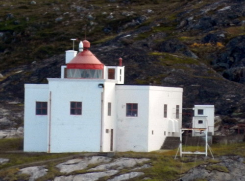
1896. Active; focal plane 77 m (253 ft); white flash every 30 s. 20 m (66 ft) square pyramidal wood tower, clad with iron panels, with lantern and gallery. Lighthouse painted white, lantern red. The 1-1/2 story keeper's house, generator house, and other station buildings are all of more recent (1950s-1960s) origin. A photo by Alex Robins is at the top of this page, the Lighthouse Association has a page for the lighthouse, Jens Gressmyr has a great closeup and a panoramic view, Trabas has Ronald Wöhrn's photo, Bash has a view from the sea, the Kystverkmusea has a page for the lighthouse, Anders Nøkling has a street view, and Google has a satellite view. The keeper's house is available for rustic overnight accommodations. This is Norway's easternmost lighthouse. Located atop Hornøya, a huge rock island just off the harbor of Vardø. Accessible only by boat; there is a daily boat .from the twon's waterfront. Site open, tower closed. . ARLHS NOR-267; NF-968500; Admiralty L4210; NGA 14616.
* Vardøhavn (2?)
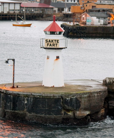
Date unknown. Active; focal plane 9 m (29 ft); white, red or green light depending on direction, occulting once every 6 s. 7 m (23 ft) round fiberglass tower with lantern and gallery. Lighthouse painted white; lantern roof is red. Bash's photo is at right, Trabas has Capt. Peter's photo, a closeup and a nice view are available, Eivind Rinde has a 2017 photo, and Google has an indistinct satellite view and a very distant street view. Located at the end of the west mole protecting the harbor of Vardø. Accessible by walking the mole. Site open, tower closed. ARLHS NOR-444; NF-968700; Admiralty L4212; NGA 14620.
* Guldringnes
Date unknown. Active; focal plane 8 m (26 ft); white, red or green light depending on direction, occulting once every 6 s. 7.5 m (25 ft) lantern and gallery supported by four straightpiles. Lantern painted white with a red roof, piles painted black. Trabas has Capt. Peter's photo, Bash has a distant view (misidentified as Reinøysundet), and Google has a distant street view and a distant satellite view. Located on the south point of Vardø. Accessible by a short walk from town. Site open, tower closed. NF-969500; Admiralty L4220; NGA 14636.
Svartnes (2)
Date unknown. Active; focal plane 8 m (26 ft); white, red or green light depending on direction, occulting twice every 8 s. 5 m (17 ft) round cylindrical fiberglass tower with lantern and gallery. Lighthouse colored white, lantern roof red. Trabas has Capt. Peter's closeup photo and Google has a satellite view and a very distant street view. The earlier light was a lantern supported by piles. Located on a promontory on the mainland opposite Vardø. Site open, tower closed. NF-969700; Admiralty L4222; NGA 14640.
Vardøhavn Fyr
Vardøhavn Light, Vardø, October 2010
Flickr Creative Commons photo by C.W. Bash
(sakte fart = slow speed)
Kibergneset
Date unknown. Active; focal plane unknown; two white flashes every 10 s. 4 m (13 ft) round lantern and snow screen, painted white with a red roof and mounted on a concrete pad. Trabas has Capt. Peter's closeup photo, Ole Grove Jørgensen has a 2019 photo, and Bing has an indistinct satellite view. This light marks the eastern tip of the Varanger Peninsula. Located on a promontory about 10 km (6 mi) south of Vardø. Accessible by a hiking trail from Kiberg. Site open, tower closed. NF-970500; Admiralty L4228; NGA 14664.
* Ytre Kiberg
Date unknown (station established 1893). Active; focal plane 6 m (20 ft); white, red or green light depending on direction, occulting twice every 8 s. 6 m (20 ft) square wood tower with lantern and gallery. Lighthouse painted white, lantern roof red. Trabas has Capt. Peter's closeup photo, Olav Næss has a photo, Google has a closeup street view, and Bing has a distant satellite view. Located on the waterfront of Kiberg. Site open, tower closed. NF-970700; Admiralty L4230; NGA 14668.

Vadsø Lighthouses

Vadsø, located on the north shore of the Varangerfjord, has a population of about 6000 and is the administrative center for Finnmark.

*
[Store Vadsøya]
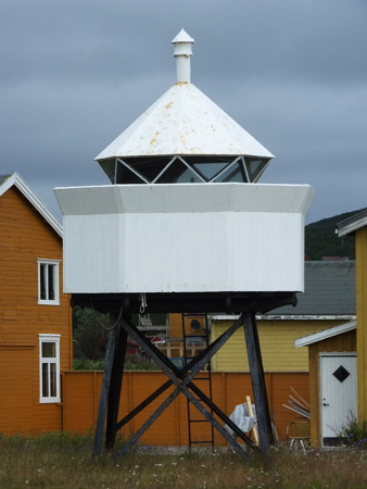
Date unknown (station established 1898). Active; focal plane 26 m (85 ft); white, red or green light depending on direction, occulting three times every 10 s. 3 m (10 ft) octagonal lantern and snow screen, painted white with a red roof and mounted on a concrete base. Trabas has Capt. Peter's closeup photo, Bash has a photo, and Google has a street view and a distant satellite view. Located on the hilltop above Vadsø. Site open, tower closed. NF-973300; Admiralty L4244; NGA 14708.
Vadsø Havn (?)
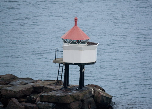
Date unknown (station established 1900). Inactive since 2021. 5.5 m (18 ft) lantern on a platform supported by piles; lantern painted white with a red roof. Bash's photo is at right, Trabas has Capt. Peter's photo, another photo is available, and Google has a distant satellite view and a very distant street view. This light has probably been removed. It has been replaced by a light on a post (green light, 2 s on, 2 s off). Located at the end of the south breakwater mole of Vadsø, at the west end of Store Vadsø. Accessible by walking the mole. Site open, tower closed. ex-NF-973500. Active light: NF-973503; Admiralty L4245; NGA 14712.
Vadsø Havn Fyr
Vadsø Havn Light, Vadsø, October 2010
Flickr Creative Commons photo by C.W. Bash
* Vestre Jakobselv (1) (relocated)
Date unknown. Inactive since 2014. 6 m (20 ft) square skeletal tower with lantern and gallery. Lighthouse painted white, lantern roof red, skeletal legs black. Capt. Peter's photo is at right, Jens Gressmyr has a photo, Marinas.com has aerial photos and Google has a distant street view and a satellite view. In 2014 the lighthouse was replaced by a light on a post. The original lighthouse was relocated to the base of the mole. Capt. Peter has a photo of the post light and the photo at right of the relocated lighthouse. Located at the base of the west mole at Vestre Jakobselv, an inlet on the north side of the Varangerfjord about 20 km (13 mi) west of Vadsø. Site open, tower closed.
* Vestre Jakobselv (3)
Date unknown (2018-19). Active; focal plane about 9 m (30 ft); white, red or green light, depending on direction, occulting twice every 8 s. Approx. 7 m (23 ft) round fiberglass tower colored white with two black horizontal bands and a red lantern. Jarno Kurki has a 2023 photo and Google has a street view and a satellite view. Located at the end of the west mole at Vestre Jakobselv. Accessible by walking the mole. Site open, tower closed. NF-975000; Admiralty L4250; NGA 14732.

Nesseby (Upper Varangerfjord) Lighthouses
Mortensnes
Date unknown. Active; focal plane 10 m (33 ft); white, red or green light depending on direction, 2 s on, 2 s off. 6 m (20 ft) lantern and gallery supported by four straightpiles. Lighthouse painted white, lantern white with a red roof. Trabas has Capt. Peter's closeup photo and Bing has a distant satellite view. This light is in the Mortensnes Cultural Heritage Site near the Varanger Sami Museum (Várjjat Sámi Musea). Located on a promontory on the north side of the fjord about 25 km (15 mi) east of Nesseby. Site open, tower closed. NF-975500; Admiralty L4252; NGA 14744.
#Nesseby Molo (1)
Date unknown. Replaced. This was formerly a 4 m (13 ft) octagonal lantern, painted white with a red roof and mounted on a short concrete post. Trabas has Capt. Peter's recent photo showing that the light (focal plane 6 m (20 ft); green light, 1 s on, 1 s off) is now on a simple mast. Bing has a satellite view of the location. Located at the end of the breakwater mole at Nesseby. Site open. Active light: NF-975900; Admiralty L4254.5; NGA 14758.
#Mæskfjord Range Rear (1)
Date unknown. Replaced and later removed. This was a 6.5 m (21 ft) lantern on a platform supported by piles. Bing has a satellite view but the light is no longer seen in Google's street view. The light (focal plane 23 m (75 ft); white light, 2 s on, 2 s off) is now on a post. The range guides vessels into the Mæskfjord, a narrow inlet at the northwestern corner of the Varangerfjord. Trabas has Capt. Peter's photo and Google has a street view of the front light, in a small lantern on the shore of the fjord beside the E75 highway. Located in a field north of the fjord. Site status unknown. Active light: NF-977000; Admiralty L4256.1; NGA 14764.

Vestre Jacobselv Light, Vestre Jacobselv, July 2016
photo copyright Capt. Peter Mosselberger; used by permission
#Rabbenes (1)
Date unknown. Replaced. This was a 7 m (23 ft) lantern on a platform supported by piles. Trabas has Capt. Peter's photo and Bing has a satellite view. The light is now on a post (focal plane 6 m (20 ft); red flash every 2 s). Located on a headland near the extreme western end of the Varangerfjord. Site status unknown. ex-NF-976500. Active light: NF-976502; Admiralty L4255; NGA 14768.
Veidneset
Date unknown. Active; focal plane 10.5 m (34 ft); two flashes every 10 s, white, red or green depending on direction. 7 m (23 ft) concrete post light with lantern and gallery. Lighthouse painted white, lantern roof red. Trabas has Capt. Peter's photo and Google has a satellite view. Located on the upper south side of the Varangerfjord about 8 km (5 mi) south of Nesseby. Site open, tower closed. NF-977500; Admiralty L4257; NGA 14748.
Storskjær
Date unknown. Active; focal plane 12 m (39 ft); white, red or green light, depending on direction, occulting twice every 8 s. 6.5 m (21 ft) concrete post light with lantern and gallery. Lighthouse painted white, lantern roof red. Trabas has Capt. Peter's photo and Google has a distant satellite view. Located on a skerry off a prominent cape on the central south side of the Varangerfjord. Accessible only by boat. Site open, tower closed. NF-978000; Admiralty L4259; NGA 14740.

Sør-Varangerfjord (Varangerfjord Southside) Lighthouses
[Bugøynes]
Date unknown (station established 1909). Active; focal plane 25 m (82 ft); white, red or green light depending on direction, occulting once every 6 s. 3 m (10 ft) octagonal lantern, painted white with a red roof. Trabas has Capt. Peter's closeup photo, the light is at the far left in a photo of the harbor, Google has a very distant street view, and Bing has a distant satellite view. Bugøynes is a fishing port on the south side of the fjord opposite Vadsø. Located on a promontory sheltering the harbor. Site status unknown, probably open; tower closed. NF-978500; Admiralty L4260; NGA 14772.
Skogerøypynten
Date unknown. Active; focal plane 6 m (20 ft); white, red or green light depending on direction, 3 s on, 3 s off. 6 m (20 ft) lantern and gallery supported by four straightpiles. Lighthouse painted white, lantern white with a red roof, piles black. Trabas has Capt. Peter's photo and Bing has a satellite view. Located on a skerry in the Neidenfjord, which extends southward from the Varangerfjord, in a remote area about 20 km (13 mi) west of Kirkenes. Accessible only by boat. Site open, tower closed. NF-980000; Admiralty L4268; NGA 14804.
Kjelmsøysund
Date unknown. Active; focal plane 24.5 m (80 ft); flash every 5 s, white, red or green depending on direction. 4 m (13 ft) octagonal lantern, painted white with a red roof , mounted on a concrete base. Trabas has Boucher's photo, Bash has a photo, and Google has a distant satellite view. This light guides vessels entering the Kjelmsøysund, the passage on the west side of the island of Kjelmsøy. Located on a steep slope on the southwestern coast of Kjelmsøy. Accessible only by boat. Site open, tower closed. NF-981000; Admiralty L4272; NGA 14812.
Kjelmsøy
Date unknown. Active; focal plane 16 m (52 ft); two flashes every 10 s, white, red or green depending on direction. 6.5 m (21 ft) lantern and gallery supported by four straightpiles. Lighthouse painted white, lantern white with a red roof, piles black. Trabas has Siering's photo, Bash has a view from the sea, and Bing has a distant satellite view. This light guides vessels entering the Bøkfjord, which leads from the south side of the Varangerfjord to the port of Sør-Varanger. Located at the southeastern point of Kjelmsøy. NF-981500; Admiralty L4274; NGA 14816.
Bøkfjord (2)
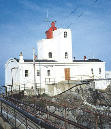
1948 (station established 1910). Active; focal plane 33 m (108 ft); two white flashes every 15 s. 10 m (33 ft) square cylindrical concrete tower with lantern and gallery, attached to a 2-story concrete keeper's house. Lighthouse painted white, lantern red. Trabas has Boucher's photo (also seen at right), the Lighthouse Association has a page for the lighthouse, Bash has a view from the sea, Bernd Claußen has another view from the sea, the Kystverkmusea also has a page for the lighthouse, Marinas.com has aerial photos, and Bing has a satellite view of the station. Clearly a sibling of the Helnes Fyr (see Hammerfest Area). This was the last staffed station in Norway, automated in 2006. Located at the east entrance to the Bøkfjord. This location is only 10 km (6 mi) from the Russian border. Accessible only by boat. Site and tower closed. . ARLHS NOR-064; NF-982500; Admiralty L4276; NGA 14828.
Bøkfjord Fyr
Bøkfjord Light, Sør-Varangerfjord, September 2011
photo copyright Michael Boucher; used by permission
[Sjøgrensen (Maritime Border) Range Front]
Date unknown. Active; focal plane 56 m (184 ft); white, red or green light occulting once every 6 s. Lantern mounted on a platform at the base of a 15 m (49 ft) rectangular concrete daymark panel. Lantern painted white with a red roof; daymark painted orange. Trabas has Capt. Peter's photo and Bing has an indistinct satellite view. The range marks the maritime border between Norway and Russia on the east side of the Varangerfjord. The rear light is similar, but the lantern is above the daymark panel. Located on the Norwegian side of the border. Site and tower closed. NF-985000; Admiralty L4290; NGA 14844.
Sjøgrensen (Maritime Border) Range Rear
Date unknown. Active; focal plane 97 m (318 ft); white light occulting once every 6 s. 20 m (66 ft) skeletal tower with lantern, carrying a large rectangular daymark panel. Lantern painted white with a red roof; daymark painted orange. Trabas has Capt. Peter's photo and Bing has an indistinct satellite view. Located 300 m (330 yd) south southwest of the front light. Site and tower closed. NF-985100; Admiralty L4290.1; NGA 14848.

Information available on lost lighthouses:

Notable faux lighthouses:

Adjoining pages: East: Pachenga Area | West: Hammerfest Area

Return to the Lighthouse Directory index | Ratings key

Posted August 3, 2006. Checked and revised October 11, 2023. Lighthouses: 38. Site copyright 2023 Russ Rowlett and the University of North Carolina at Chapel Hill.