Lighthouses of Russia: Pechenga Area

Russia (Россия, Rossiya in Russian) is by far the world's largest country, spanning a little over 150° in longitude. It is organized as the Russian Federation (Rossiyskaya Federatsiya) with members known as federal subjects (sub'yekty federatsii). Russia is primarily a continental nation but it has important coastlines on the Baltic, Black, and Caspian Seas and very long coastlines on the Arctic Ocean and North Pacific Ocean. To guard these coasts it operates hundreds of lighthouses, many of them historic.

The northwestern corner of Russia lies on the Barents Sea (Barentsevo More), an arm of the Arctic Ocean. In Murmansk Oblast (province), the broad, eastward-pointing Kola Peninsula (Kolskiy Poluostrov) separates the Barents Sea from the nearly-enclosed White Sea, which extends southward more than 500 km (300 mi). This page includes lighthouses of the northwestern corner of Murmansk Oblast, including the Pachenga, Zaozyorsk, and Vidyayevo districts. This area adjoins the Norwegian border northwest of Murmansk city.

The Russian word for a lighthouse is mayak (маяк); ostrov is an island, poluostrov is a peninsula, kosa is a sandy spit, rif is a reef, mys is a cape, bukhta is a bay, zaliv is a larger bay or gulf, proliv is a strait, reka is a river, and gavan' is a harbor.

Russian lighthouses are owned by the Russian Navy and maintained by the Office of Navigation and Oceanography (Управление навигации и океанографии).

ARLHS numbers are from the ARLHS World List of Lights. Admiralty numbers are from volume L of the Admiralty List of Lights & Fog Signals. Russian light list (RU) numbers are from Russian Navy Publication 2103, as reported by the Admiralty. U.S. NGA numbers are from Publication 115.

General Sources
Online List of Lights - Russia - Arctic Sea Coast
Photos by various photographers posted by Alexander Trabas.
Lighthouses in Murmansk Oblast
Photos by various photographers available from Wikimedia.
World of Lighthouses - Arctic Coast of Russia
Photos by various photographers available from Lightphotos.net.
Russische Leuchttürme auf historischen Postkarten
Historic postcard images posted by Klaus Huelse.

Tsyp-Navolokskiy Light, Rybachiy Peninsula, July 2008
Wikimedia Creative Commons photo by Sergey Gruzdev
Pechengskiy District Lighthouses

The Pechengskiy District, adjoining the Norwegian and Finnish borders, is named for the seaport of Pechenga, formerly called by its Finnish and Swedish name Petsamo. After the collapse of the Russian Empire the Petsamo area was assigned to newly-independent Finland in 1920. Occupied by Soviet troops in 1944, it was ceded to the Soviet Union under the 1946 Soviet-Finnish peace treaty. Historically a center for nickel mining, Pechenga is now a small town with a population of about 3100. Former Finnish names are shown in brackets {}.

Pechenga Bay and Varangerfjord Lighthouses
Mys Vor'ema
Date unknown. Active; focal plane 14 m (46 ft); white flash every 3 s. 4 m (13 ft) octagonal lantern, mounted on a concrete or stone base. Lantern painted white. Trabas has Capt. Peter Mosselberger's photo, Lightphotos.net has the same photo, and Bing has a satellite view. Located on a promontory on the south side of the Varangerfjord, about 400 m (1/4 mi) west of the Norwegian border. Site status unknown. Admiralty L6002.
Mys Paltusovo Pero
Date unknown. Active; focal plane 25 m (82 ft); white flash every 5 s. 6 m (20 ft) tripod mounted atop a square 1-story concrete equipment shelter. Tripod painted yellow, equipment shelter white. No photo available but Google has an indistinct satellite view. Located on the west side of the entrance to Pechenga Bay, the estuary of the Pechenga River. Site status unknown. RU-0018; Admiralty L6006.
Lodeynyy
Date unknown. Active; focal plane 9 m (30 ft); green flash every 5 s. 4 m (13 ft) square pyramidal wood skeletal tower with a slatted daymark painted white with a black vertical stripe. Bing has a satellite view. Located on a prominent cape on the west side of Pechenga Bay at Liinakhamari. Site status unknown. Admiralty L6013.
Mys Devkin
Date unknown. Active; focal plane unknown; red light, pattern unknown. Tower perhaps 10 m (33 ft) high. No photo available but Google has a satellite view. Located on a cape on the west side of the bay about 10 km (6 mi) south of the entrance. Site status unknown. Admiralty L6015.
Pechengskiye Mys Krestovyy (2?)
Date unknown. Active; focal plane about 8 m (26 ft); white flash every 3 s. 6 m (20 ft) lantern mounted on a square concrete base. Entire lighthouse is white. Lightphotos.net also has a view from the sea by Oleg Stepanov, another view from the sea by Igor Moiseev is available, and Google has a satellite view. Typically Scandinavian in design, this light was probably installed under the Finnish administration. There is another Mys Krestovyy (Cape Cross) Light on the Kola Peninsula. Google also has a satellite view that may show ruins of an older lighthouse higher on the cape. Located on a headland at a sharp bend of Pechenga Bay about 10 km (6 mi) south of the entrance. Site status unknown. RU-0030; Admiralty L6014.
Pechenga {Petsamo} Range Front
Date unknown. Active; focal plane 14 m (46 ft); continuous red light. 13 m (43 ft) square skeletal tower. No photo available but the shadow of the tower is clear in a Google satellite view. This is the entrance range for Pechenga Bay. Located on the east side of the bay about 8 km (5 mi) south of the entrance. Site status unknown. RU-0025; Admiralty L6011; NGA 14856.
Pechenga {Petsamo} Range Rear
Date unknown. Active; focal plane 33 m (108 ft); continuous red light. 14 m (46 ft) square skeletal tower. No photo available but the shadow of the tower is clear in a Bing satellite view. Located on the east side of the bay about 800 m (1/2 mi) south of the front light. Site status unknown. RU-0026; Admiralty L6011.1; NGA 14860.
Pechengskiye (Mys Romanov) {Numeroniemi} (2)
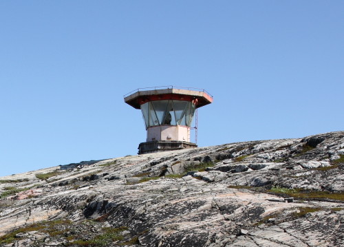
1977 (station established 1912). Active; focal plane 35 m (115 ft); two long flashes every 15 s, white or red depending on direction. 4 m (13 ft) octagonal lantern with a large flat roof. Lantern painted red. A photo is at right, Anatoly Basov has a closeup, and Google has an indistinct satellite view. Lightphotos.net has Oleg Stepanov's closeup of the original light. Located on a cape, the end of the Liinakhamari Peninsula, on the east side of the entrance to Pechenga Bay. Site status unknown. ARLHS ERU-111; RU-0020; Admiralty L6010; NGA 14852.
Pechengskiye Light
Pechengskiye (Mys Romanov) Light, Pechenga Bay, July 2008
ex-Panoramio photo copyright Denn68; used by permission
Ostrov Bol'shoy Aynov {Iso Heinäsaari} (2)
Date unknown. Active; focal plane 29 m (95 ft); white flash every 4.5 s. 9 m (30 ft) square masonry or concrete tower, unpainted. A small red lantern is mounted on the roof of the building. No photo available but Google has a satellite view. Located on the west side of an island in the Varangerfjord about 6 km (3.5 mi) off the Russian shore. Accessible only by boat. Site status unknown. RU-0055; Admiralty L6028; NGA 14876.
Ostrov Malyy Aynov {Pieni Heinäsaari}
Date unknown. Active; focal plane 30 m (98 ft); green flash every 5 s. 6 m (20 ft) square pyramidal tower, lower portion enclosed and upper portion partially enclosed by a slatted daymark. Entire lighthouse painted yellow. No photo available but Google has a distant satellite view. Located near the south point of the island, about 2.5 km (1.5 mi) southeast of Bol'shoy Aynov. Accessible only by boat. Site status unknown. RU-0050; Admiralty L6029; NGA 14872.

Rybachiy Peninsula Lighthouses
The Rybachiy (Fisher) Peninsula is really a large island, roughly 65 km (40 mi) by 25 km (15 mi), connected to the mainland by a narrow (2 km wide) isthmus. The eastern 2/3 of the island is separated from the mainland by Motovskiy Bay.

Mys Koroviy
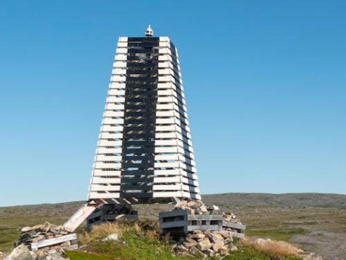
Date unknown. Active; focal plane unknown; white light, pattern unknown. Approx. 7 m (23 ft) square pyramidal skeletal tower covered with a slatted daymark painted white with a black vertical stripe on each face. Vyacheslav Vertyanov has the 2021 photo seen at right and Google has an indistinct satellite view. Located on a prominent cape on the northwest coast of the Rybachiy Peninsula. Site status unknown. Admiralty L6031.
 

Mys Koroviy Light, Rybachiy Peninsula, August 2021
Google Maps photo by Vyacheslav Vertyanov
 
Ostrov Bol'shoy Kiy
Date unknown. Active; focal plane 31 m (102 ft); red flash every 3 s. 6 m (20 ft) square pyramidal tower, probably wood, painted red with a black vertical stripe on each side. No photo available but Bing has a satellite view. Located on the southwest side of Bol'shoy Kiy, a round island about 3.5 km (2 mi) south of Mys Kiy on the west side of the Rybachiy Peninsula. Accessible only by boat. Site status unknown. Admiralty L6040; NGA 14885.
Mys Kiyskiy
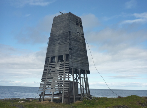
Date unknown. Inactive; listed with focal plane 17 m (56 ft); white flash every 3 s. 12 m (39 ft) square pyramidal skeletal wood tower, mostly enclosed with a slatted daymark that is supposed to be painted with black and white horizontal bands. Sergey Borisov's 2013 photo at right shows that the lighthouse is abandoned and falling into ruins. Google has an indistinct satellite view. Located on a promontory on the west side of the Rybachiy Peninsula, about 13 km (8 mi) southwest of Vaidaguba. Site status unknown. ARLHS ERU-099; RU-0070; Admiralty L6044.
Vaidagubskiy (Mys Nemetskiy) {Majakkaniemi, Vaitolahti} (3?)
Date unknown (1950s?). Inactive. Approx. 8 m (26 ft) hexagonal turret mounted on a 2-story red brick building, now falling into ruins. A photo is below right, another photo is available, and Google has an indistinct satellite view. This light station marks the beginning of the approach to Pechenga (Petsamo); it also stands at the eastern entrance to Norway's Varangerfjord. The original lighthouse was a small keeper's cottage with a lantern at one end. Probably destroyed during World War II, it was replaced with a 7.5 m (25 ft) "white pyramidal structure with red band," according to a 1950 light list. Located at the western end of the Rybachiy Peninsula. Site status unknown.

Mys Kiyskiy Light, Rybachiy Peninsula, August 2013
Wikimedia Creative Commons photo by Sergey Borisov
Vaidagubskiy (Mys Nemetskiy) {Majakkaniemi, Vaitolahti} (4?)
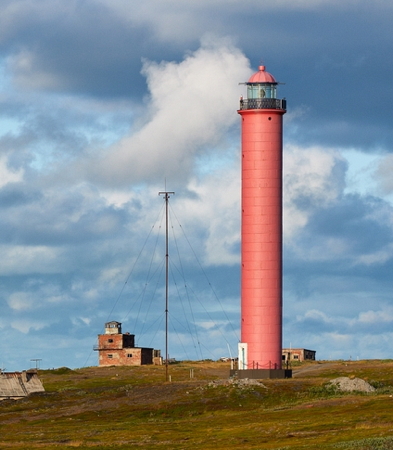
1966 (?) (station established 1896). Active; focal plane 62 m (203 ft); three green flashes every 11 s. 29 m (95 ft) round tower with lantern and gallery, painted bright red. Fog horn (Morse code "U": two shorts and one long, every 30 s). A photo is at right, Lightphotos.net has a photo of the station by Dmitry Begizov, Wikimedia has Sergey Gruzdev's photo, Jan Majer has a photo, a 2023 photo is available, and Google has a satellite view. ARLHS ERU-071; RU-0080; Admiralty L6046; NGA 14892.
[Mys Lazar' (2?)]
Date unknown. Apparently an inactive daybeacon. 19 m (62 ft) square pyramidal skeletal tower carrying a large triangular slatted daymark. A 2020 photo shows an interesting and apparently new beacon. Google has a satellite view. Located on a sharp promontory on the north side of the Rybachiy Peninsula, about 16 km (10 mi) west of Tsypnavolok. Site status unknown. Not listed by the Admiralty.
Mys Lausch
Date unknown. Active; focal plane 18 m (59 ft); flash every 3 s, white, red or green depending on direction (?). 7 m (23 ft) triangular pyramidal skeletal tower enclosed by a slatted daymark painted with red and white horizontal bands. No photo available but Bing has a satellite view. Located on a promontory about 3 km (2 mi) northwest of Tsypnavolok. Site status unknown. RU-0095; Admiralty L6081.
Tsyp-Navolokskiy (Tsypnavolok, Mys Voronkovskiy) (5?)
1979 (?) (station established 1899). Active; focal plane 54 m (177 ft); two white flashes followed by two red flashes, every 16 s. 32 m (105 ft) round tower with lantern and gallery, painted with red and white horizontal bands; lantern is red. Fog horn (five blasts every 60 s). Sergey Gruzdev's 2008 photo is at the top of this page, Lightphotos.net has several photos, Wikipedia's Tsypnavolok page has a photo taken from the lighthouse, another photo is available, and Bing has a satellite view. This lighthouse marks the beginning of the approach to Murmansk. Older light lists describe a series of three or four skeletal towers preceding the modern lighthouse. Located at the eastern end of the Rybachiy Peninsula. Site status unknown. ARLHS ERU-025; RU-0100; Admiralty L6082; NGA 14904.
Tsyp-Navolok Bay (Tsyp-Navolokskiy Southeast)
Date unknown. Active; focal plane 22 m (72 ft); two white flashes every 5.1 s. 8 m (26 ft) square pyramidal tower, painted with red and white horizontal bands. Bing has a satellite view. Located at the tip of a narrow peninsula projecting southeast from Tsyp-Navolok. Site status unknown. Admiralty L6088; NGA 14905.

Vaidagubskiy Light, Rybachiy Peninsula, October 2012
ex-Google Plus photo by Filler Никоносович
Mys Malyy Korabel'nyy (Ribachiy Mys Gorodetskiy, Gorodetzki Point)
Date unknown. Active; focal plane 40 m (131 ft); white flash every 4 s. 12 m (39 ft) square pyramidal tower, painted black with a white vertical stripe. No photo available but Bing has a satellite view. Located at the southeastern tip of the Rybachiy Peninsula, marking the entrance to the Motovskiy Bay. Accessible only by boat. Site status unknown. RU-0120; Admiralty L6094; NGA 14916.
Mys Eyna (Zyna)
Date unknown. Active; focal plane 20 m (66 ft); green flash every 2.5 s. 6 m (20 ft) square pyramidal tower, painted black with a white horizontal band. No photo available but Google has a satellite view. Located on a promontory on the south side of the Rybachiy Peninsula. Accessible only by boat. Site status unknown. RU-0125; Admiralty L6093; NGA 14920.
Mys Motka
Date unknown. Active; focal plane 15 m (49 ft); red flash every 6 s. 6 m (20 ft) square pyramidal tower, painted white with a red diagonal stripe. No photo available but Google has a satellite view. Located on a headland on the south side of the Rybachiy Peninsula, marking the entrance to Motka Bay from Motovskiy Bay. Site status unknown. Admiralty L6096; NGA 14924.
Mys Priglubyy
Date unknown. Active; focal plane 10 m (33 ft). 4 m (13 ft) square tower, painted with red and white horizontal bands, mounted on a large square platform. A distant view is available and Google has a distant satellite view. Located in the center of a very narrow passage in Motka Bay. Accessible only by boat, but easy to see from shore. Site open, tower closed. RU-0150; Admiralty L6098.
Motka-Sredniy
Date unknown. Active; focal plane and lightcharacteristic unknown. Approx. 8 m (26 ft) sqaure pyramidal tower rising from a square base. Entire lighthouse is white. The lighthouse is at the extreme right edge of Denis Kononchyk's photo and Google has a satellite view. Located on the west side of lower Motka Bay. Site status unknown. Admiralty L6097.

Zaozyorsk and Ura Bay Lighthouses

These lights are on the south side of Motovskiy Bay, which is sheltered by the Rybachiy Peninsula. This area has long been the location of several important military and naval bases. In particular, both Zaozyorsk and Vidyayevo on Ura Bay are bases for Russian submarines.

Zaozyorsk Municipal District Lighthouses
Mys Pikshuyev
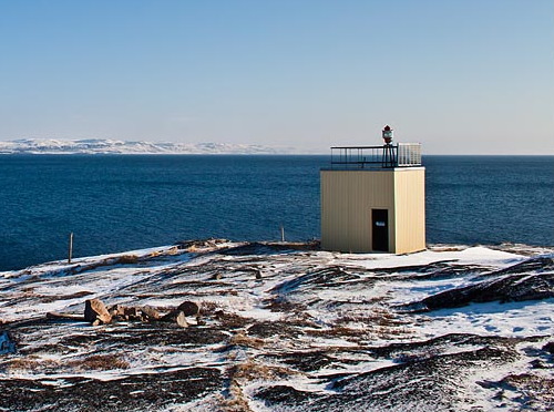
Date unknown (station established 1931). Active; focal plane 14 m (46 ft); two white flashes every 6 s. 6 m (20 ft) square equipment building with the light mounted on a short post on the roof. Building painted yellow. A photo is at right and Google has a satellite view. This light is part of a historic meteorological station. Located on a prominent cape about 5 km (3 mi) north of Zaozyorsk. Site status unknown. ARLHS ERU-112; Admiralty L6130; RU-0185; NGA 14948.
Ostrov Kuvshin-Zapadnyy
Date unknown. Active; focal plane 38 m (125 ft); green flash every 5 s. 7 m (23 ft) square pyramidal skeletal tower, enclosed by a slatted daymark painted black with a white horizontal band. Sergey Bratikov has a very distant view, and Google has a satellite view. Located on an island in the entrance to the bay of Zaozyorsk. Accessible only by boat. Site status unknown. ARLHS ERU-101; RU-0190; Admiralty L6136.

Vidyayevo Municipal District (Ura Bay Area) Lighthouses
Ostrov Bol'shoy Arskiy
Date unknown. Inactive. 7 m (23 ft) square skeletal tower, partially enclosed with a slatted daymark painted black with a white diagonal stripe. Stepan Striyan has a view from the sea and Google has an indistinct satellite view. The light was active in the 1950s but it has been inactive at least since 2000. Located at the northeast end of the island of Bol'shoy Arskiy, about 8 km (5 mi) west of the Ura Bay entrance. Accessible only by boat. Site status unknown.
Mys Pikshuyev Light, Zaozyorsk, March 2012
photo copyright angrymanz; permission requested

Bukta Malaya Lukovaya (Malyy Lukovyy)
Date unknown. Active; focal plane 27 m (89 ft); red flash every 4 s. 12 m (39 ft) round cylindrical tower colored red with a white horizontal band. No photo available but Bing has a satellite view. This light probably replaced the Bol'shoy Arskiy light. Located on a promontory about 2 km (1.2 mi) east of Bol'shoy Arskiy and 6 km (4 mi) west of the Ura Bay entrance. Accessible only by boat. Site status unknown. Admiralty L6160.
Mys Vyev-Navolok (Vyevnavolok) (2?)
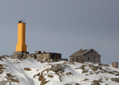
Date unknown (station established by 1950). Active; focal plane 44 m (144 ft); flash every 6 s, white or red depending on direction. 15 m (49 ft) square cylindrical concrete tower painted yellow. Sergei Bozhenko's photo is at right, Lightphotos.net has a closeup photo, Vitali Ka has a street view, and Google has an indistinct satellite view. The lighthouse stands at the west side of the entrance to Ura Bay and Port Vladimir. Site status unknown. ARLHS ERU-026; Admiralty L6172; RU-0210; NGA 14968.
Ostrov Shalim
Date unknown. Active; focal plane about 45 m (148 ft); red light, characteristic unknown. Approx. 8 m (26 ft) cylindrical concrete tower painted red. Geir Ole Søreng has a view from the sea, another view from the sea (fourth from last photo on the page) is available and Bing has an indistinct satellite view. Ostrov Shalim is a large island on the east side of Ura Bay. Located on the west coast of the island. Accessible only by boat. Site status unknown. Admiralty L6163.
Ostrov Yeretik (Eretik) Vostochnyy
Date unknown. Active; focal plane 34 m (112 ft); green flash every 3 s. 6 m (20 ft) octagonal cylindrical concrete tower, painted red. Lightphotos.net has Valeriy Lyushkov's photo, Sergey Bozhenko has a photo, and Google has an indistinct satellite view. This light and the next one frame the narrow eastern entrance to Port Vladimir. Located at the eastern point of an island about 4 km (2.5 mi) east of Port Vladimir. Accessible only by boat. Site status unknown. Admiralty L6175; RU-0225.
Ostrova Shurinovy (Shurinovskiy)
Date unknown. Active; focal plane 26 m (85 ft); flash every 5 s, white, red or green depending on direction. 7 m (23 ft) octagonal cylindrical concrete tower, painted with black and white horizontal bands. Sergey Bozhenko has a a photo and a more distant view from the sea and Google has a satellite view. Located on a small island about 500 m (0.4 mi) east of the previous light. Accessible only by boat. Site status unknown. ARLHS ERU-122; Admiralty L6208; RU-0235; NGA 14976.

Mys Vyev-Navolok Light, Port Vladimir, March 2013
ex-Panoramio photo copyright Sergei Bozhenko; used by permission

Information available on lost lighthouses:

Notable faux lighthouses:

Adjoining pages: East: Murmansk Area | West: Vadsø Area

Return to the Lighthouse Directory index | Ratings key

Posted December 7, 2005. Checked and revised February 19, 2024. Lighthouses: 31. Site copyright 2024 Russ Rowlett and the University of North Carolina at Chapel Hill.