Lighthouses of Norway: Northern Trøndelag

The Kingdom of Norway (Norge in Norwegian) is one of the world's most maritime nations. The country is long and narrow, with drowned valleys called fjords that bring the sea far inland in most regions. The mainland coast is estimated to be 2650 km (1650 mi) long and when all the islands and minor indentations are counted the total coastline approaches an astonishing 60,000 km (37,500 mi), long enough the go around the world one and a half times. With such a lengthy and rocky shore it's not surprising that Norway has a large number of lighthouses.

Norway is divided into 11 counties (fylker) and the counties are divided into municipalities (kommuner). This page lists lighthouses of the municipalities of Nærøysund and Leka at the northern end of Trøndelag County in northwestern Norway. This area was in Nord-Trøndelag County until that county was merged with Sør-Trøndelag in 2018. In 2020 the former municipalities of Nærøy and Vikna were merged to form Nærøysund.

In Norwegian a lighthouse is a fyrtårn (fire tower) or simply a fyr; a fyrlykt is a beacon and a lyktehus is a lantern. Øy is an island, holmen is an islet, skjær is a skerry (a tiny island or rocky reef), sund is a strait (often between an island and the mainland), bukt is a bay, nes is a headland, and havn is a harbor.

Aids to navigation in Norway are maintained by the Kystverket (Coast Directorate), an agency of the Ministry of Transport and Communications.

ARLHS numbers are from the ARLHS World List of Lights. NF numbers are from the Norsk Fyrliste. Admiralty numbers are from volume L of the Admiralty List of Lights & Fog Signals. U.S. NGA List numbers are from Publication 115.

General Sources
Norsk Fyrhistorisk Forening
News and photos from the Norwegian Lighthouse Association.
Online List of Lights - Norway
Photos by various photographers posted by Alexander Trabas. Many of the photos for this area are by Ronald Wöhrn, Michael Boucher or Arno Siering.
Lighthouse Pages from Anke and Jens - Norway
Excellent photos of more than 60 Norwegian lighthouses.
Norway's Fjorden and Lighthouses
Photos taken by Charles W. Bash on a 2010 cruise from Bergen to North Cape.
Leuchttürme an der norwegischen Küste
Photos posted by Bernd Claußen.
Lighthouses in Trøndelag
Photos by various photographers available from Wikimedia.
Norwegische Leuchttürme auf historischen Postkarten
Historic postcard images posted by Klaus Huelse.
Liste over Norske Fyr
From Norwegian Wikipedia, a handy list of Norwegian light stations with their dates of establishment.
Norsk Fyrliste
The official Norwegian light list can be downloaded in six .pdf volumes.
GPSNautical Charts
Navigational chart for northern Trøndelag.
Navionics Charts
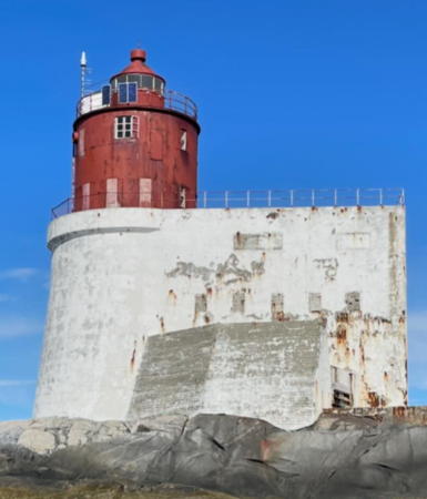
Navigation chart for Trøndelag.

Gjeslingan Fyr
Gjæslingan Light, Vikna, August 2006
Flickr photo copyright maybritth; permission requested

Nærøysund Kommune Lighthouses

Southern Nærøy Lighthouses
Kjeøy (Kjeøya)
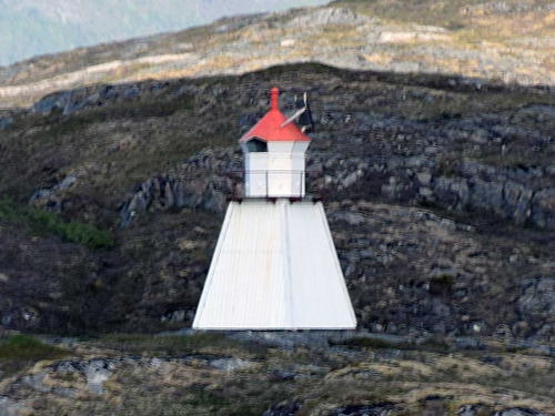
Date unknown. Active; focal plane 8.5 m (28 ft); white, red or green light depending on direction, occulting twice every 8 s. 6 m (20 ft) square skeletal tower with lantern and gallery, covered with siding. Lighthouse painted white; lantern roof is red. Erik Stenvik has a photo, Michel Kocha has a 2023 view from the sea, and Google has a satellite view. Located at the western tip of Kjeøy, an island near the east end of the Foldafjord, about 4 km (2.5 mi) southeast of Geisnes. Accessible only by boat. Site open, tower closed. NF-516500; Admiralty L1790; NGA 8760.
#Bertillen (1)
Date unknown. Replaced about 2016. This was a 14 m (46 ft) lantern on a platform supported by piles. Lantern painted white with a red roof. No photo available and Bing has only a fuzzy satellite view. The active light (focal plane 10 m (33 ft); green light, 1 s on, 1 s off) is now on a post. Located on a skerry about 3 km (2 mi) south of Nærøy. Accessible only by boat. Site open, tower closed. ex-NF-525600. Current light: NF-525601; Admiralty L1828.2.

Vikna Southside Lighthouses
The former Vikna municipality includes a large archipelago of small islands off Nærøy, separated from the mainland by the narrow Nærøysund strait. Two bridges cross the strait, connecting the islands to the mainland. The permanent population of the islands is about 4100.
[Rørvik]
Date unknown. Active; focal plane 9 m (30 ft); white, red or green light depending on direction, occulting once every 6 s. 3 m (10 ft) octagonal lantern, painted white with a red roof. Trabas has Siering's closeup photo, a view from the sea is available, and Google has a distant satellite view. Ships on Norway's inside passage make a tight turn around this light, so it is often photographed. Rørvik was the seat of government for Vikna Kommune. Located on Lille Lyngøy, a small island about 1.6 km (1 mi) east of the Rørvik waterfront. Accessible only by boat. Site open, tower closed. NF-552000; Admiralty L1909; NGA 9032.
Nærøysund (2)
1984. Active; focal plane 14 m (46 ft); white, red or green light depending on direction, occulting once every 6 s. 14 m (46 ft) concrete post with lantern and gallery. Lighthouse painted white; lantern roof is red. Trabas has Siering's photo, another photo is available, and Google has a distant satellite view. Located at the shoreline near the historic lighthouse. Site open, tower closed. NF-551500; Admiralty L1904; NGA 9016.
Nærøysund (1)
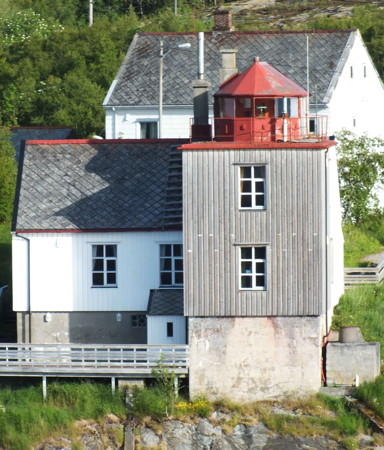
1904. Inactive since 1984. 13 m (43 ft) lantern atop a 2-story wood keeper's house. House painted or stained light brown; lantern painted red. Siering's photo is at right, the Lighthouse Association has a page for the lighthouse, a closeup 2007 photo and a view from the fjord are available, MarineTraffic.com has Kenneth Yttergard's photo, and Google has a distant satellite view. The lighthouse replaced the Prestøy lighthouse on the other side of the Nærøysund. The house has a modern appearance, so probably it has been altered from the original. In October 2019 the Nærøysund Kommune purchased the lighthouse; various possible uses for the building are under consideration. Located on the north side of the Nærøysund, which separates the island of Vikna from the mainland, about 2 km (1.2 mi) southwest of Rørvik. Site open, tower closed. Owner/site manager: Nærøysund Kommune. . ARLHS NOR-175.
Stamnesskjærflua (Stavenesskjaerflu)
Date unknown. Active; focal plane 5.5 m (19 ft); white, red or green light depending on direction, 3 s on, 3 s off. 7 m (23 ft) lantern and gallery mounted on four straight piles. Lantern painted white with a red roof, piles painted black. No photo available but Google has a distant satellite view. Located on a reef off the southern end of Indre Vikna. Accessible only by boat. Site open, tower closed. NF-550100; Admiralty L1899; NGA 9008.
Sleipskjæret (Skaepskjaer)
Date unknown. Active; focal plane 6.5 m (21 ft); white, red or green light depending on direction, 3 s on, 3 s off. 6 m (20 ft) square tower with lantern and gallery. Lighthouse painted white, lantern roof red. No photo available but Bing has an indistinct satellite view. Located on a small island just off the south coast of Mellom Vikna. Site open, tower closed. NF-540000; Admiralty L1893; NGA 9000.
Nærøysund Light
Nærøysund Light, Vikna, June 2012
photo copyright Arno Siering; used by permission
Langholmen
Date unknown. Active; focal plane 6.5 m (21 ft); white, red or green light depending on direction, 3 s on, 3 s off. 7.5 m (25 ft) lantern mounted on a platform supported by four straight piles. Lantern painted white with a red roof. No photo available but Bing has a satellite view. Located on the south end of an island in the narrow channel between Ytre Vikna and Mellom Vikna. Accessible only by boat. Site open, tower closed. NF-541000; Admiralty L1894; NGA 8972.
Sør-Hysskjæret (Sore Hyseskjaer)
Date unknown. Active; focal plane 6 m (20 ft); white, red or green light depending on direction, occulting three times every 12 s. 6.5 m (21 ft) lantern mounted on a platform supported by four straight piles. Lantern painted white with a red roof. No photo available but Bing has a distant satellite view. Located on a skerry off the south coast of Ytre Vikna. Accessible only by boat. Site open, tower closed. NF-538000; Admiralty L1889; NGA 8944.
Skarvskjæret
Date unknown. Active; focal plane 12 m (39 ft); white, red or green light depending on direction, 3 s on, 3 s off. 9.5 m (31 ft) lantern mounted on a platform supported by four straight piles. Lantern painted white with a red roof. No photo available but Bing has a distant satellite view. Located on a skerry southeast of Bondøy. Accessible only by boat. Site open, tower closed. NF-537500; Admiralty L1888; NGA 8940.
Grinna
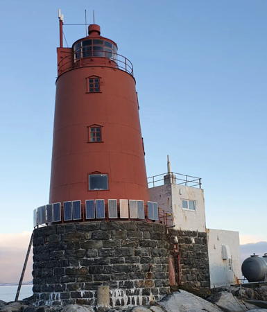
1904. Active; focal plane 23 m (75 ft); white, red or green light depending on direction, occulting once every 6 s. 19 m (62 ft) round cast iron tower with lantern and gallery, mounted on a round stone base. Entire lighthouse painted red. A small keeper's house, also mounted on a tall stone base, stands next to the tower. Trabas has Siering's photo (also seen at right), a closeup and another photo (last photo on the page) are available, and Google has a satellite view. The cultural preservation organization Jøa Kystlag has a lease on the lighthouse but it's not known if they will develop it for visitors. Located on a small skerry about 6 km (3.7 mi) east northeast of the Gjeslingan lighthouse in the mouth of the Follafjord. Accessible only by boat. Site and tower closed. . ARLHS NOR-099; NF-529500; Admiralty L1842; NGA 8872.
Gjæslingan (Gjeslingan)
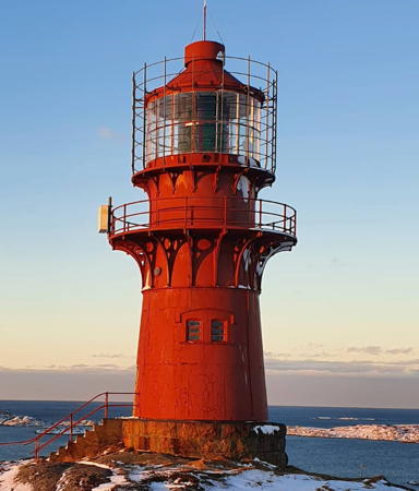
1877. Active; focal plane 24 m (79 ft); white flash every 10 s; also, continuous red and green lights are shown at 19 m (62 ft) to guide ships around nearby rocks. 24 m (79 ft) round cylindrical cast iron tower with lantern and gallery, incorporating keeper's quarters, mounted on a round stone base. Entire lighthouse painted red. A 4-story white concrete building was built behind the lighthouse in 1938; the building included a boat house, machine shop, and living quarters. Much of the interior of the concrete building has been destroyed by storm waves since the lighthouse was automated in 1987. A photo is at the top of this page, Per Arvid Åsen has a 2006 photo, a closeup (about 1/5 the way down the page) is available, Trabas has Wöhrn's photo, and Google has a distant satellite view. Wikipedia's article has a historic photo. Located on a small skerry in the wide mouth of the Follafjord about 15 km (9 mi) north of Lauvsnes. Accessible only by boat. Site and tower closed. . ARLHS NOR-018; NF-530000; Admiralty L1846; NGA 8876.

Grinna Light, Vikna, October 2012
photo by Arno Siering; used by permission
Sør-Gjæslingan (Sondre Skarveskjær)
Date unknown. Active; focal plane 7 m (23 ft); white, red or green light depending on direction, occulting once every 6 s. 6 m (20 ft) square tower with lantern and gallery. Lighthouse painted white, lantern roof red. The light is at the center of a distant Google street view and Bing has an indistinct satellite view. Located about 4 km (2.5 mi) northwest of the Gjæslingan lighthouse. Site open, tower closed. NF-531000; Admiralty L1852; NGA 8880.
Tronflesa
Date unknown. Active; focal plane 14.5 m (48 ft); flash every 5 s, white, red or green depending on direction. 8 m (26 ft) lantern and gallery mounted on a stone cairn. No photo available but Bing has a distant satellite view. Located on a skerry about 3 km (1.8 mi) southwest of Heimvær. Accessible only by boat. Site open, tower closed. NF-531700; Admiralty L1856; NGA 8888.
Heimvær (Heimværet)
Date unknown. Active; focal plane 6 m (20 ft); white, red or green light depending on direction, occulting twice every 8 s. 6 m (20 ft) square pyramidal tower with lantern and gallery. Lighthouse painted white, lantern roof red. Andreas Hamnes has a closeup photo, Tom Hanslien has a photo, the light is at the lower left of a Google street view, and Bing has an indistinct satellite view. Located at the harbor entrance of Heimvær, on a small island about 16 km (10 mi) southwest of Rørvik. Accessible only by boat. Site open, tower closed. NF-531500; Admiralty L1854; NGA 8884.
Kvitingen
1909. Active; focal plane 8 m (26 ft); white, red or green light depending on direction, occulting three times every 12 s. 5 m (17 ft) lantern and gallery mounted on four straight piles. Lantern painted white with a red roof, piles painted black. Andreas Hamnes has a photo and Bing has a distant satellite view. Located on a small island about 1.6 km (1 mi) north of Heimvær. Accessible only by boat. Site open, tower closed. NF-532000; Admiralty L1858; NGA 8892.
Nord-Blikkøya (Nordre Bilkoy)
Date unknown. Active; focal plane 7.5 m (25 ft); white, red or green light depending on direction, 3 s on, 3 s off. 6 m (20 ft) square tower with lantern and gallery. Lighthouse painted white, lantern roof red. No photo available but Bing has a satellite view. Located on a small island about 5 km (3 mi) northeast of Heimvær. Accessible only by boat. Site open, tower closed. NF-532500; Admiralty L1862; NGA 8900.
Nordøyan
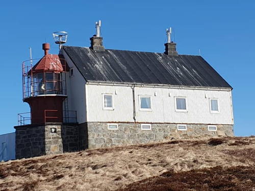
1890. Active; focal plane 36 m (118 ft); continuous white light with a more intense flash every 40 s. 10 m (33 ft) round cylindrical cast iron tower with lantern and gallery, mounted on a round stone base. The back of the lantern is attached to the 2-1/2 story wood keeper's house. Light tower and lantern painted red, house painted white. The original 1st order Fresnel lens remains in use. Roy Jøssund's photo is at right, Wikimedia has Danckert Monrad-Krohn's photo, Per Arvid Åsen has a 2017 closeup photo, and Google has a very distant satellite view. The light is now listed as the rear light of a range with Purkholmen (next entry) as the front light. Located on a small island at the southwestern end of the Nordøyan (North Islands) about 10 km (6 mi) southwest of the principal island of Vikna. Accessible only by boat. Site open, tower closed. . ARLHS NOR-033; NF-533500; Admiralty L1874.1 (ex-L1868); NGA 8908.

Nordøyan Light, Vikna, April 2019
Instagram photo by Roy Jøssund
Purkholmen
Date unknown. Active; focal plane 7 m (23 ft); white, red or green light depending on direction, occulting three times every 10 s. 8.5 m (28 ft) lantern mounted on a platform supported by four straight piles. Lantern painted white with a red roof. Torgeir Kleven has a photo but the light is not seen in Google's distant satellite view. Located on an island at the entrance to Nordøyan harbor. Accessible only by boat. Site open, tower closed. NF-534500; Admiralty L1874; NGA 8916.
Veirskaftet
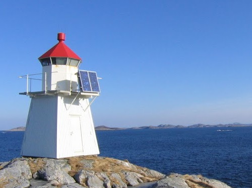
Date unknown. Active; focal plane 14 m (46 ft); flash every 5 s, white, red or green depending on direction. 6 m (20 ft) square tower with lantern and gallery. Lighthouse painted white, lantern roof red. Dag Hallvard Ystgaard's photo is at right but the light is not seen in Google's distant satellite view. Located on the northern tip of Nordøyan. Site open, tower closed. NF-535100; Admiralty L1882; NGA 8952.
Bendøyskæret
Date unknown. Active; focal plane 6 m (20 ft); white, red or green light depending on direction, occulting twice every 8 s. 9 m (30 ft) concrete post with lantern and gallery. Lighthouse painted white; lantern roof is red. No photo available but Bing has a distant satellite view. Located on a skerry about 5.5 km (3.5 mi) northeast of the Nordøyan lighthouse. Accessible only by boat. Site open, tower closed. NF-535500; Admiralty L1884; NGA 8924.
Råholmen
Date unknown. Active; focal plane 13.5 m (45 ft); white, red or green light depending on direction, occulting twice every 8 s. 6 m (20 ft) square tower with lantern and gallery. Lighthouse painted white, lantern roof red. No photo available but Google has a distant satellite view. Located on a skerry about 4 km (2.5 mi) northeast of Nordøyan. Site open, tower closed. NF-535300; Admiralty L1883; NGA 8956.
Veirskaftet Light
Veirskaftet Light, Vikna, March 2005
ex-Picasaweb Creative Commons photo by Dag Hallvard Ystgaard

Vikna Northside Lighthouses
Masterskjæret
Date unknown. Active; focal plane 7.5 m (25 ft); white, red or green light depending on direction, 3 s on, 3 s off. 9 m (30 ft) concrete post with lantern and gallery. Lighthouse painted white; lantern roof is red. No photo available but Google has a distant satellite view. Located on a skerry in the sound between Ytre Vikna and Kalvøy. Accessible only by boat. Site open, tower closed. NF-544500; Admiralty L1895.4; NGA 9092.
Nedre Måholmen (Måholmen Range Front)
Date unknown. Active; focal plane 11 m (36 ft); white light, 2 s on, 2 s off. 7 m (23 ft) square tower with lantern and gallery. Lighthouse painted white; lantern painted white with a red roof. No photo available but Google has a distant satellite view. Måholmen is an irregular island off the northeast coast of Kalvøy. Located near the west end of Måholmen. Accessible only by boat. Site open, tower closed. NF-555400; Admiralty L1930; NGA 9112.
Øvre Måholmen (Måholmen Range Rear)
Date unknown. Active; focal plane 26 m (85 ft); flash every 5 s, white, red or green depending on direction. 17.5 m (57 ft) square skeletal tower with enclosed upper portion, lantern and gallery. Lighthouse painted white, lantern roof red. No photo available but Google has a distant satellite view. This light is at the location of the historic Måholmen Fyr (1907), which burned to the ground in 1934. A historic photo of the ruins is available and these ruins can still be seen. Located near the east end of Måholmen. Accessible only by boat. Site open, tower closed. NF-555300; Admiralty L1930.1; NGA 9108.
Fruflesa
Date unknown. Active; focal plane 13.5 m (45 ft); white, red or green light depending on direction, occulting twice every 8 s. 12 m (39 ft) concrete post with lantern and gallery. Lighthouse painted white; lantern roof is red. No photo available but Bing has a distant satellite view. Located on a skerry just off the northeast coast of Kvaløy, and island off the northeast coast of Ytre Vikna. Accessible only by boat. Site open, tower closed. NF-557000; Admiralty L1933; NGA 9100.
Ravmnholmen (Ravnholmen)
Date unknown. Active; focal plane 8 m (26 ft); white, red or green light depending on direction, occulting twice every 8 s. 6 m (20 ft) square tower with lantern and gallery. Lighthouse painted white, lantern roof red. No photo available but Bing has a very distant satellite view. Located on a skerry in a narrow passage around the east end of Indre Vikna. Site open, tower closed. NF-554200; Admiralty L1924; NGA 9072.

Northern Nærøy Lighthouses
Hummulråsa
Date unknown. Active; focal plane 15 m (49 ft); white, red or green light depending on direction, occulting three times every 10 s. 6 m (20 ft) square skeletal tower with lantern and gallery, covered with siding. Lighthouse painted white; lantern roof is red. Trabas has Wöhrn's photo, another photo (last photo on the page) is available, and Bing has a satellite view. Located at the southeastern end of the island of Svinøy. Site status unknown. NF-553500; Admiralty L1918; NGA 9056.
Svinstein
Date unknown. Active; focal plane 7 m (23 ft); white, red or green light depending on direction, occulting twice every 8 s. 5 m (17 ft) concrete post with lantern and gallery. Lighthouse painted white; lantern roof is red. Trabas has Wöhrn's distant view and Bing has a distant satellite view. Located on a bluff on the north side of Kvingla, marking a very narrow point of the inside passage about 10 km (6 mi) northeast of Rørvik. Site status unknown. NF-553100; Admiralty L1916; NGA 9052.
Øvre Gjerdinga (Range Rear)
Date unknown. Probably inactive; listed with focal plane 28.5 m (94 ft); white light, 3 s on, 3 s off. 7 m (23 ft) square skeletal tower with lantern and gallery, covered with siding. Lighthouse painted white; lantern roof is red. Trabas has Jim Smith's photo seen at right and Bing has a satellite view. The range guides vessels approaching the north end of the Nærøysund from the open sea. The front light is in a small lantern. This light was dropped from the Norsk Fyrliste but is still on the Admiralty list. Located on heights near the western end of the island of Gjerdinga. Site status unknown. ex-NF-553600; Admiralty L1920.1; NGA 9068.
Rypån
Date unknown. Active; focal plane 8 m (26 ft); white, red or green light depending on direction, occulting twice every 8 s. 9.5 m (31 ft) concrete post with lantern and gallery. Lighthouse painted white, lantern roof red. Trabas has Wöhrn's distant view and Bing has a satellite view. Located on a skerry in the Risværfjord, a section of the inland passage south of Dolma. Accessible only by boat. Site open, tower closed. NF-562300; Admiralty L1949; NGA 9160.
 

Øvre Gjerdinga Light, Nærøy
photo copyright Jim Smith; used by permission

Leka Kommune Lighthouses

Sklinna Lighthouses
Jakobsflesa
Date unknown. Active; focal plane 13 m (23 ft); flash every 5 s, white, red or green depending on direction. 12 m (39 ft) concrete post with lantern and gallery. Lighthouse painted white; lantern roof is red. No photo available but Bing has a satellite view. Located on the largest of a group of small islands about 8 km (5 mi) south of Sklinna. Accessible only by boat. Site open, tower closed. NF-558000; Admiralty L1934; NGA 9096.
Sklinna
1910. Active; focal plane 45 m (148 ft); white, red or green light depending on direction, occulting once every 6 s. 14 m (46 ft) round cast iron tower with lantern and gallery, painted red. The original 2nd order Fresnel lens remains in use. 1-1/2 story wood keeper's house, engine house, and other light station buildings also preserved. Roy Jøssund's photo is at right, Wikimedia has Danckert Monrad-Krohn's photo, a closeup and a more distant view are available, and Bing has a satellite view. Sklinna is a former fishing village, abandoned in the 1890s; the area is now a protected nature reserve. Located at the highest point of the isolated island of Heimøya, easternmost island of the Sklinna archipleago, about 15 km (9 mi) north of Vikna. Accessible only by boat. Site open, tower closed. . ARLHS NOR-207; NF-560000; Admiralty L1936; NGA 9128.
Bårdskjeret (Bardskjaer)
Date unknown. Active; focal plane 9 m (30 ft); white, red or green light depending on direction, occulting twice every 8 s. 6 m (20 ft) lantern mounted on a platform supported by piles. Lantern painted white with a red roof. No photo available but Bing has a distant satellite view. Located on a skerry at the north entrance to Sklinna harbor. Accessible only by boat. Site open, tower closed. NF-560200; Admiralty L1940; NGA 9136.

Madsøy and Leka Area Lighthouses
Madsøygalten
Date unknown. Active; focal plane 5 m (17 ft); white, red or green light depending on direction, occulting twice every 8 s. 6.5 m (20 ft) lantern and gallery mounted on a stone cairn. Lantern painted white with a red roof. Trabas has Siering's distant view and Bing has a distant satellite view. Located on a skerry in the inland passage off the south side of Madsøy. Accessible only by boat. Site open, tower closed. NF-564500; Admiralty L1960; NGA 9184.
Knerten
Date unknown. Active; focal plane 5 m (17 ft); white, red or green light depending on direction, occulting three times every 12 s. 6.5 m (20 ft) lantern and gallery mounted on a stone cairn. Lantern painted white with a red roof. Klaus Hornauer has a distant drone view and Bing has a distant satellite view. Located on a skerry in the eastern entrance to the Frøviksund, the passage between Madsøy and Leka. Accessible only by boat. Site open, tower closed. NF-565400; Admiralty L1968; NGA 9200.
* Leknesvika (Bryggeneset)
1911. Active; focal plane about 5.5 m (19 ft); white, red or green light depending on direction, occulting once every 6 s. 6 m (20 ft) square tower with lantern and gallery. Lighthouse painted white, lantern roof red. No photo available but Bing has a distant satellite view. Located on the waterfront at Leknesvika, a small port on the northeast coast of Leka. Site open, tower closed. NF-566000; Admiralty L1974; NGA 9208.

Sklinna Light, Leka, January 2021
Instagram photo by Roy Jøssund
Steinsflesa
Date unknown. Active; focal plane 10.5 m (34 ft); flash every 5 s, white, red or green depending on direction. 6.5 m (21 ft) square tower with lantern and gallery. Lighthouse painted white, lantern roof red. No photo available but Bing has a distant satellite view. Located on the northernmost of a chain of small islands and skerries in the Hortafjord, a broad passage north of Leka. Accessible only by boat. Site open, tower closed. NF-566400; Admiralty L1982; NGA 9216.

Horta Islands Lighthouses
Abrahamskjeret (Abrahamskjaer)
Date unknown. Active; focal plane 7.5 m (25 ft); white, red or green light depending on direction, 3 s on, 3 s off. 9 m (30 ft) lantern mounted on a platform supported by piles. Lantern painted white with a red roof. No photo available but Bing has a distant satellite view. Located on a skerry at the southern end of the Horta Islands, about 16 km (10 mi) northwest of Leka. Accessible only by boat. Site open, tower closed. NF-567000; Admiralty L1984; NGA 9220.
Emåriskjeret (Emariskjaer)
Date unknown. Active; focal plane 7 m (23 ft); white, red or green light depending on direction, occulting twice every 8 s. 7 m (23 ft) lantern and gallery mounted on a stone cairn. Lantern painted white with a red roof. No photo available but Bing has a distant satellite view. Located on a skerry at the southeastern corner of the Horta Islands. Accessible only by boat. Site open, tower closed. NF-567100; Admiralty L1986; NGA 9224.

Information available on lost lighthouses:

Notable faux lighthouses:

Adjoining pages: South: Central Trøndelag | North: Southern Helgeland

Return to the Lighthouse Directory index | Ratings key

Posted August 3, 2006. Checked and revised July 12, 2023. Lighthouses: 39. Site copyright 2023 Russ Rowlett and the University of North Carolina at Chapel Hill.