Lighthouses of Norway: Northern Helgeland

The Kingdom of Norway (Norge in Norwegian) is one of the world's most maritime nations. The country is long and narrow, with drowned valleys called fjords that bring the sea far inland in most regions. The mainland coast is estimated to be 2650 km (1650 mi) long and when all the islands and minor indentations are counted the total coastline approaches an astonishing 60,000 km (37,500 mi), long enough the go around the world one and a half times. With such a lengthy and rocky shore it's not surprising that Norway has a large number of lighthouses.

Norway is divided into counties (fylker) and the counties are divided into townships (kommuner). Helgeland is the southernmost district of Norway's Nordland County; roughly speaking, it includes that portion of the country's northwest coast between Trøndelag (the Trondheim area) and the Arctic Circle. There are no major ports in the district, but there are many small fishing villages. The coastline is quite rugged and deeply indented by many fjords. This page includes lighthouses of the northern portion of Helgeland, including the townships of Rana, Lurøy, Træna, and Rodøy.

In Norwegian a lighthouse is a fyrtårn (fire tower) or simply a fyr; a fyrlykt is a beacon and a lyktehus is a lantern. Øy is an island, holmen is an islet, skjær is a skerry (a tiny island or rocky reef), sund is a strait (often between an island and the mainland), bukt is a bay, nes is a headland, and havn is a harbor.

Aids to navigation in Norway are maintained by the Kystverket (Coast Directorate), an agency of the Ministry of Transport and Communications.

ARLHS numbers are from the ARLHS World List of Lights. NF numbers are from the Norsk Fyrliste. Admiralty numbers are from volume L of the Admiralty List of Lights & Fog Signals. U.S. NGA List numbers are from Publication 115.

General Sources
Norsk Fyrhistorisk Forening
News and photos from the Norwegian Lighthouse Association.
Online List of Lights - Norway
Photos by various photographers posted by Alexander Trabas. Many of the photos for this area are by Ronald Wöhrn, Michael Boucher or Arno Siering.
Lighthouse Pages from Anke and Jens - Norway
Excellent photos of more than 60 Norwegian lighthouses.
Norway's Fjorden and Lighthouses
Photos taken by Charles W. Bash on a 2010 cruise from Bergen to North Cape.
Leuchttürme an der norwegischen Küste
Photos posted by Bernd Claußen.
Lighthouses in Nordland
Photos by various photographers available from Wikimedia.
Norwegische Leuchttürme auf historischen Postkarten
Historic postcard images posted by Klaus Huelse.
Liste over Norske Fyr
From Wikipedia, a handy list of Norwegian light stations with their dates of establishment.
Norsk Fyrliste
The official Norwegian light list can be downloaded in six .pdf volumes.
GPSNavigationCharts
Navigation chart information for Helgeland.
Navionics Charts
Navigation chart for Helgeland.


Arctic Circle Monument and Vikingen Light, Rødøy, June 2010
ex-Panoramio Creative Commons photo by Kasos
Rana Lighthouse
* Haukneset
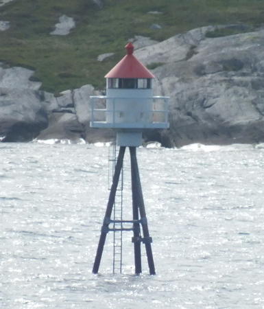
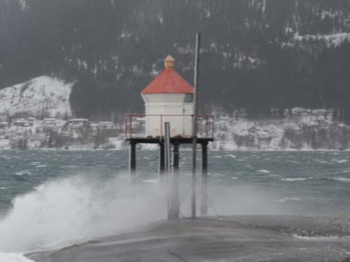
Date unknown. Active; focal plane 7 m (23 ft); white, red or green light depending on direction, occulting once every 6 s. 6 m (20 ft) lantern and gallery, mounted on four straight piles. Lantern painted white with a red roof, piles painted black. Bjørn Kvitnes has the photo seen at right, a sunset photo is available and Google has a satellite view. Located on the south side of the Ranafjord near Åga, about 8 km (5 mi) southwest of Mo i Rana. Site open, tower closed. NF-622000; Admiralty L2226; NGA 9728.

Lurøy Lighthouses
Naustholmen (Lovund)
Date unknown. Active; focal plane 6.5 m (21 ft); white, red or green light depending on direction, occulting twice every 8 s. 5 m (17 ft) concrete post with lantern and gallery. Lighthouse painted white, lantern roof red. A view from the sea is available, Google has a street view, Chris Martinussen has a drone view, and Google has a satellite view. Located at the seaward corner of the fishing port of Lovund. Site status unknown. NF-658000; Admiralty L2341; NGA 10164.
Kvittripskjær
Date unknown. Active; focal plane 9 m (30 ft); white, red or green light depending on direction, occulting twice every 8 s. 6 m (20 ft) concrete post with lantern and gallery. Lighthouse painted white, lantern roof red. No photo available but Bing has an indistinct satellite view. Located on a small island on the northwest side of the Lovund group. Site status unknown. NF-659000; Admiralty L2345; NGA 10188.
Otervær
Date unknown. Active; focal plane 11 m (36 ft); white, red or green light depending on direction, 3 s on, 3 s off. 7.5 m (25 ft) lantern and gallery mounted on a stone cairn. Lantern painted white with a red roof. No photo available but Google has a satellite view. Located on a skerry, one of group about 2.5 km (1.5 mi) northeast of Lovund. Accessible only by boat. Site open, tower closed. NF-658800; Admiralty L2344; NGA 10160.

Haukneset Light, Rana, February 2015
Google Maps photo by Bjørn Kvitnes
Kvartelsøy
Date unknown. Active; focal plane 6.5 m (21 ft); white, red or green light depending on direction, 3 s on, 3 s off. 6.5 m (21 ft) concrete post with lantern and gallery. Lighthouse painted white, lantern roof red. No photo available but Google has a satellite view. Located on a small island west of Ulvøy. Accessible only by boat. Site open, tower closed. NF-632000; Admiralty L2254; NGA 10152.
Brimholman (Bremholmen, Sleneset)
Date unknown. Active; focal plane 9.5 m (31 ft); white, red or green light depending on direction, occulting twice every 8 s. 5 m (17 ft) square tower with lantern and gallery. Lighthouse painted white, lantern roof red. No photo available but Google has a satellite view. Located on a small island off the harbor of Sleneset and the east end of Solvær. Accessible only by boat. Site open, tower closed. NF-633600; Admiralty L2255.4; NGA 9784.
Lille Mangvarden
Date unknown. Active; focal plane 11 m (36 ft); white, red or green light depending on direction, 3 s on 3 s off. 6 m (20 ft) square tower with lantern and gallery. Lighthouse painted white, lantern roof red. No photo available but Google has a satellite view. Located on a small island about halfway between Tomma and Ulvøy. Accessible only by boat. Site open, tower closed. NF-631200; Admiralty L2252; NGA 9876.
Hagenholmen (Hagaholmen) (1)
Date unknown. Apparently replaced. Previously listed as active; focal plane 8.5 m (28 ft); red or green light depending on direction, occulting twice every 8 s. This is or was a 6.5 m (21 ft) square tower with lantern and gallery. Lighthouse painted white, lantern roof red. No photo available but Google has a satellite view. The Admiralty announced in April 2022 that the light was "to be removed" in 2022. The Fyrliste has changed the light number but has no data on the new light. Located on a small island off the west coast of Lurøy. Accessible only by boat. Site open, tower closed. ex-NF-636000. Active light: NF-636010; Admiralty L2262; NGA 9916.
Bonetskjær (Bonettskjær)
Date unknown. Active; focal plane 6.5 m (21 ft); white, red or green light depending on direction, occulting once every 6 s. 6 m (20 ft) lantern and gallery, mounted on four straight piles. Lantern painted white with a red roof, piles painted black. Arno Siering's photo is at right, Bash has a photo, Trabas has Wöhrn's photo, and Google has a satellite view. Locate on a skerry at the entrance to the harbor of Innerkvarøya. Accessible only by boat. Site open, tower closed. NF-626200; Admiralty L2242; NGA 9776.
Skjærflesa
Date unknown. Active; focal plane 11.5 m (38 ft); white, red or green light depending on direction, 3 s on, 3 s off. 8 m (26 ft) concrete post with lantern and gallery. Lighthouse painted white, lantern roof red. No photo available but Bing has a satellite view. Located on a skerry about 10 km (6 mi) south of Nesøy. Accessible only by boat. Site open, tower closed. NF-666500; Admiralty L2371.4; NGA 10276.

Bonetskjær Light, Lurøy, October 2012
photo copyright Arno Siering; used by permission
Oksholmen
Date unknown. Active; focal plane 6 m (20 ft); white, red or green light depending on direction, 2 s on, 2 s off. 6.5 m (21 ft) concrete post with lantern and gallery. Lighthouse painted white, lantern roof red. No photo available but Google has a satellite view. Located on an island off the southeast side of Nesøy. Accessible only by boat. Site open, tower closed. NF-666000; Admiralty L2371; NGA 10312.
Kloholmen
Date unknown. Active; focal plane 15 m (49 ft); white, red or green light depending on direction, 2 s on, 2 s off. 6 m (20 ft) lantern mounted on a platform supported by piles. Lantern painted white with a red roof. No photo available but Google has a satellite view. Located on a skerry about 2 km (1.2 mi) southwest of Nesøy. Accessible only by boat. Site open, tower closed. NF-667000; Admiralty L2372; NGA 10280.
Svartoksen
Date unknown. Active; focal plane 9 m (30 ft); quick-flashing green light. 7 m (23 ft) lantern and gallery mounted on a stone cairn. No photo available but Google has a satellite view. Located on a skerry about 1 km (0.6 mi) north of the Kloholmen light. Accessible only by boat. Site open, tower closed. NF-667100; Admiralty L2372.4; NGA 10284.
Lille Svenningen
Date unknown. Active; focal plane 7 m (23 ft); white, red or green light depending on direction, 2 s on, 2 s off. 5.5 m (18 ft) concrete post with lantern and gallery. Lighthouse painted white, lantern roof red. No photo available but Google has a satellite view. Located on an island off the west side of Nesøy. Accessible only by boat. Site open, tower closed. NF-667600; Admiralty L2373; NGA 10300.

Træna Lighthouses
Traena is an archipelago about 50 km (30 mi) off the mainland coast. There are at least a thousand islands, islets, and rocks in the archipelago, but only four inhabited islands. The permanent population of the islands is about 500.
Træna (Sørholmen)
1877. Active; focal plane 37 m (121 ft); one long white flash every 10 s. 21 m (69 ft) round cast iron tower with double gallery, mounted on an octagonal stone base and attached to a 2-story keeper's house. Lantern removed. The tower is painted red; the stone base is painted white. Per Pedersen's photo is at right, Morten Storsveen has a 2021 photo, a 2010 photo and a good 2011 photo (fourth photo on the page) are available, a historic photo shows the lighthouse in its original form, and Google has a satellite view. In 2019 Træna Kommune and the Kystverket agreed on a plan to restore the lighthouse with an eye to making it a tourist attraction, and in 2020 the Kystverket advertised for bids on the restoration project. We need information on its progress. Located on a small island about 7 km (4.5 mi) southwest of Træna. Accessible only by boat. Site open, tower closed. . ARLHS NOR-255; NF-660000; Admiralty L2348; NGA 10196.
Røsneset
Date unknown. Active; focal plane 13 m (43 ft); white, red or green light depending on direction, occulting twice every 8 s. 6 m (20 ft) square tower with lantern and gallery. Lighthouse painted white, lantern roof red. No photo available but Bing has an indistinct satellite view. Located on the southern tip of Sanna, one of the larger islands of the Træna group. Accessible only by boat. Site open, tower closed. NF-660500; Admiralty L2352; NGA 10204.
Ålvorsneset
Date unknown. Active; focal plane 21.5 m (71 ft); flash every 5 s, white, red or green depending on direction. 9 m (30 ft) lantern on a platform supported by piles. Lantern painted white with a red roof. No photo available but Google has a satellite view. Located on the western tip of Sanna. Accessible only by boat. Site open, tower closed. NF-661000; Admiralty L2356; NGA 10208.
Bergholmen
Date unknown. Active; focal plane 17.5 m (57 ft); white, red or green light depending on direction, occulting twice every 8 s. 4.5 m (15 ft) lantern and gallery mounted on a stone base. No photo available but Google has an indistinct satellite view. This light guides vessels arriving at Træna harbor. Located on an island about 1.6 km (1 mi) east of the harbor entrance. Accessible only by boat. Site open, tower closed. NF-660400; Admiralty L2360; NGA 10232.
Ovnholmskjæret
Date unknown. Active; focal plane 13 m (43 ft); white, red or green light depending on direction, 3 s on, 3 s off. 6.5 m (21 ft) concrete post with lantern and gallery. Lighthouse painted white, lantern roof red. No photo available but Google has a satellite view. Located on a small island about 5 km (3 mi) northeast of Husøy. Accessible only by boat. Site open, tower closed. NF-661300; Admiralty L2358; NGA 10228.

Træna Light, Træna, June 2020
Facebook photo posted by TENK TRÆNA
Dørvær
Date unknown (station established 1903). Active; focal plane 10 m (3 ft); flash every 5 s, white, red or green depending on direction. 6 m (20 ft) square pyramidal tower with lantern and gallery. Lighthouse painted white, lantern roof red. No photo available but Google has an indistinct satellite view. Located on an island about 4 km (2.5 mi) south of Selvær. Accessible only by boat. Site open, tower closed. NF-663500; Admiralty L2362; NGA 10244.
Søndre (Søre) Selvær (2?)
Date unknown (station established 1904). Active; focal plane 12.5 m (41 ft); white, red or green light depending on direction, 1 s on, 1 s off. 9 m (30 ft) square pyramidal skeletal tower, covered with corrugated siding, with lantern and gallery. Tower painted gray with white trim, lantern white with a red roof. Gerhard Wolfgang Westhoff has a view from the sea and Google has an indistinct satellite view. The light was deactivated for several years around 2012 but it is back in service, perhaps with a new tower. Located on a small island off the entrance to the harbor of Selvær, an island about 13 km (8 mi) north northwest of Lovund. Site open, tower closed. NF-663100; Admiralty L2364; NGA 10252.
Kobbholmen (Kobholmen)
Date unknown. Active; focal plane 6 m (20 ft); flash every 5 s, white, red or green depending on direction. 6 m (20 ft) concrete post with lantern and gallery. Lighthouse painted white, lantern roof red. Espen Frode Eid has a photo and Google has a satellite view. Located on a reef on the west side of Selvær. Accessible only by boat. Site open, tower closed. NF-665000; Admiralty L2368; NGA 10268.

Rødøy Lighthouses
Vikingen
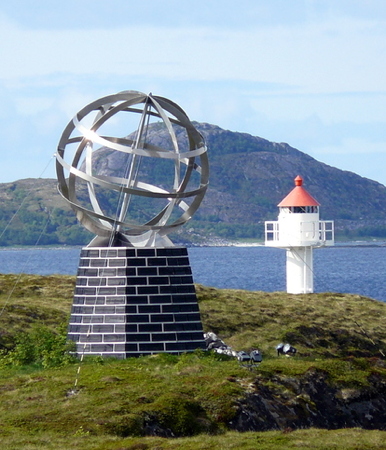
Date unknown. Active; focal plane 16 m (52 ft); white, red or green light, depending on direction, occulting twice every 8 s. Approx. 7 m (23 ft) cylindrical tower with lantern and gallery. Lighthouse painted white, lantern red. The photo at the top of this page shows the lighthouse standing next to the Arctic Circle Monument, Trabas has Wöhrn's closeup photo, Bash has a photo, and Google has a satellite view. Although the monument is widely assumed to mark the Arctic Circle, the Circle is actually about 3 km (2 mi) farther north. Located on an island off the end of a peninsula, about 2 km (1.2 mi) west northwest of Tonnes. Accessible only by boat. Site open, tower closed. NF-626400; Admiralty L2244; NGA 9780.
* Store Selsøy
Date unknown. Active; focal plane 7 m (23 ft); white, red or green light, depending on direction, occulting once every 6 s. 6 m (20 ft) concrete post with lantern and gallery. Entire lighthouse painted white. Google has a street view and a distant satellite view. Located on the waterfront at Store Selsøy, on the north side of Hestmannøy (Hestmona), an island about 7 km (4.5 mi) west northwest of Tonnes. Accessible by road. Site open, tower closed. NF-637100; Admiralty L2266; NGA 9928.
Floholmen
Date unknown. Active; focal plane 27 m (89 ft); flash every 5 s, white, red or green depending on direction. 6 m (20 ft) concrete post with lantern and gallery. Lighthouse painted white, lantern roof red. No photo available but Google has a satellite view. Located atop an island about 5 km (3 mi) northwest of Nesøy. Accessible only by boat. Site open, tower closed. NF-667700; Admiralty L2374; NGA 10304.
Kjøbmandskjær
Date unknown. Active; focal plane 8 m (26 ft); white, red or green light, depending on direction, occulting twice every 8 s. 6 m (20 ft) square skeletal tower, covered with siding, with lantern and gallery. Lighthouse painted white, lantern roof red. Trabas has Wöhrn's photo and Google has a satellite view. Located on a skerry off the northern tip of Rangsundøya. Accessible only by boat. Site open, tower closed. NF-672200; Admiralty L2393.7; NGA 10372.
Sandværken
Date unknown. Active; focal plane 7 m (23 ft); white, red or green light, depending on direction, occulting once every 6 s. 7 m (23 ft) lantern and gallery on tripod piles. Lantern painted white, roof red. Trabas has Arno Siering's photo (also seen at right) and Google has a satellite view. Located on a reef off the entrance to Rødøy. Accessible only by boat. Site open, tower closed. NF-676000; Admiralty L2406; NGA 10392.
Sandværken Light
Sandværken Light, Rødøy, June 2012
photo copyright Arno Siering; used by permission
Rørholmen
Date unknown. Active; focal plane 6 m (20 ft); white, red or green light, depending on direction, occulting once every 6 s. 6 m (20 ft) lantern and gallery mounted on a stone cairn. No photo available but Google has a satellite view. Located on an island off the southeastern tip of Gjesøy, about 6.5 km (4 mi) west of Rodøy. Accessible only by boat. Site open, tower closed. NF-678000; Admiralty L2413; NGA 10432.
Skjurøysund
Date unknown (station established 1894?). Active; focal plane 24 m (79 ft); white, red or green light, depending on direction, occulting twice every 8 s. 4 m (13 ft) octagonal lantern on a stone base. No photo available and Google has only a fuzzy satellite view of the location. Located at the southwestern point of Skjurøy, marking the southern entrance to the narrow sound separating Skjurøy and Myken. Site status unknown. NF-670400; Admiralty L2380; NGA 10324.
** Myken
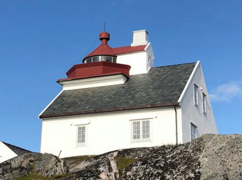
1918. Active; focal plane 40 m (131 ft); white, red or green light depending on direction, occulting once every 6 s. 12.5 m (41 ft) lantern mounted on the roof of a 1-1/2 story wood keeper's house. Lighthouse painted white, lantern red. Andreas Beining's photo is at right, Lill-Harriet Jonassen has a 2019 closeup, Sveinung Gjessing has a 2011 photo, Trabas has a photo by Pauline and Wim de Kleine, another photo is available, and Google has an indistinct satellite view. Myken is a group of small islands and skerries about 32 km (20 mi) off the mainland and 15 km (9 mi) northeast of Træna. Jutøy is the only inhabited island. Its permanent population is only about 20 but it has a larger summer population and is accessible by passenger ferry from Tonnes. The lighthouse is available for overnight accommodations (boat and lifejackets provided). Lighthouse located atop a rocky island across the harbor from the Myken waterfront. Site open, tower open to paying guests. Site manager: Myken Fyr . ARLHS NOR-032; NF-670000; Admiralty L2378; NGA 10320.
Dørgholmsund
Date unknown (station established 1894). Active; focal plane 14 m (46 ft); white, red or green light, depending on direction, 2 s on, 2 s off. 4 m (13 ft) octagonal lantern on a stone base. A photo is available (1/4 the way down the page) and Google has an indistinct satellite view. Located at the northeastern point of Skjurøy, marking the northern entrance to the narrow sound separating Skjurøy and Myken. Site status unknown. NF-670800; Admiralty L2382; NGA 10328.
Valvær (Innerøya)
Date unknown. Active; focal plane 47 m (154 ft); flash every 5 s, white, red or green depending on direction. 5.5 m (18 ft) lantern and gallery mounted on a stone cairn. No photo available but Google has a distant satellite view. Valvær is a remote island group about 15 km (9 mi) northeast of Myken. Located on the highest point of Innerøya, on the southeast side of the islands. Accessible only by boat. Site status unknown. NF-671000; Admiralty L2386; NGA 10340.

Myken Light, Rødøy, July 2019
Google Maps photo by Andreas Beining

Information available on lost lighthouses:

Notable faux lighthouses:

Adjoining pages: North: Bodø Area | South: Central Helgeland

Return to the Lighthouse Directory index | Ratings key

Posted August 3, 2006. Checked and revised August 1, 2023. Lighthouses: 32. Site copyright 2023 Russ Rowlett and the University of North Carolina at Chapel Hill.