Lighthouses of Norway: Central Helgeland

The Kingdom of Norway (Norge in Norwegian) is one of the world's most maritime nations. The country is long and narrow, with drowned valleys called fjords that bring the sea far inland in most regions. The mainland coast is estimated to be 2650 km (1650 mi) long and when all the islands and minor indentations are counted the total coastline approaches an astonishing 60,000 km (37,500 mi), long enough the go around the world one and a half times. With such a lengthy and rocky shore it's not surprising that Norway has a large number of lighthouses.

Norway is divided into counties (fylker) and the counties are divided into townships (kommuner). Helgeland is the southernmost district of Norway's Nordland County; roughly speaking, it includes that portion of the country's northwest coast between Trøndelag (the Trondheim area) and the Arctic Circle. There are no major ports in the district, but there are many small fishing villages. The coastline is quite rugged and deeply indented by many fjords. This page includes lighthouses of four townships in the central part of Helgeland, including the islands of the Herøy and Dønna townships and the nearby mainland.

In Norwegian a lighthouse is a fyrtårn (fire tower) or simply a fyr; a fyrlykt is a beacon and a lyktehus is a lantern. Øy is an island, holmen is an islet, skjær is a skerry (a tiny island or rocky reef), sund is a strait (often between an island and the mainland), bukt is a bay, nes is a headland, and havn is a harbor.

Aids to navigation in Norway are maintained by the Kystverket (Coast Directorate), an agency of the Ministry of Transport and Communications.

ARLHS numbers are from the ARLHS World List of Lights. NF numbers are from the Norsk Fyrliste. Admiralty numbers are from volume L of the Admiralty List of Lights & Fog Signals. U.S. NGA List numbers are from Publication 115.

General Sources
Norsk Fyrhistorisk Forening
News and photos from the Norwegian Lighthouse Association.
Online List of Lights - Norway
Photos by various photographers posted by Alexander Trabas. Many of the photos for this area are by Ronald Wöhrn, Michael Boucher or Arno Siering.
Lighthouse Pages from Anke and Jens - Norway
Excellent photos of more than 60 Norwegian lighthouses.
Norway's Fjorden and Lighthouses
Photos taken by Charles W. Bash on a 2010 cruise from Bergen to North Cape.
Leuchttürme an der norwegischen Küste
Photos posted by Bernd Claußen.
Lighthouses in Nordland
Photos available from Wikimedia.
Norwegische Leuchttürme auf historischen Postkarten
Historic postcard images posted by Klaus Huelse.
Norske Fyr
From Wikipedia, a handy list of Norwegian light stations with their dates of establishment.
Norsk Fyrliste
The official Norwegian light list can be downloaded in .pdf format.
GPSNavigationCharts
Navigation chart information for Helgeland.
Navionics Charts
Navigation chart for Helgeland.


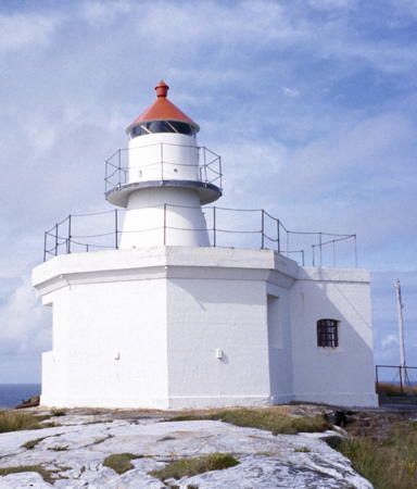
Ytterholmen Light, Herøy, July 2016
Wikimedia Creative Commons photo by the Culture Ministry
Herøy Lighthouses
Herøy is an archipelago of islands west of Alstahaug. The total population is only about 1800.

Springen
Date unknown. Active; focal plane 6 m (20 ft); white, red or green light depending on direction, occulting three times every 12 s. 9 m (30 ft) lantern mounted on a platform supported by tripod piles. Lantern painted white with a red roof. Trabas has Wöhrn's photo and Bing has a distant satellite view. Located on a skerry about 1.2 km (3/4 mi) east southeast of the Brasøy ferry terminal. Accessible only by boat. Site open, tower closed. NF-643000; Admiralty L2274.6; NGA 9940.
Gjeithammeren (Geithammeren)
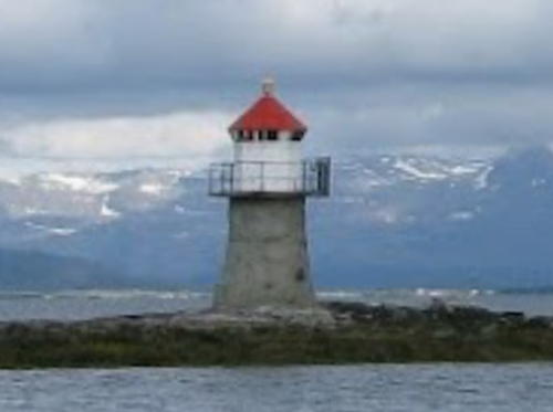
Date unknown. Active; focal plane 9 m (30 ft); white, red or green light depending on direction, 3 s on, 3 s off. 7 m (23 ft) concrete post with lantern and gallery. Lighthouse painted white, lantern roof red. Ove Sparengen's photo is at right and Google has a distant satellite view. Located on the northwestern coast of the island of Tenna. Site open, tower closed. NF-645000; Admiralty L2278; NGA 9968.
Herøysund
Date unknown. Active; focal plane 4.5 m (15 ft); white, red or green light depending on direction, occulting once every 6 s. 6 m (20 ft) lantern mounted on a platform supported by piles. Lighthouse painted white, lantern roof red. Trabas has Wöhrn's photo and Google has a distant satellite view. Located on a reef on the approach to Herøy. Accessible only by boat, but there's a good view from ferries to Herøy from Brasøy or Søvik. Site open, tower closed. NF-613700; Admiralty L2170; NGA 9624.
Hestøysund
Date unknown. Active; focal plane 4 m (13 ft); white, red or green light depending on direction, occulting once every 6 s. 6 m (20 ft) lantern mounted on a platform supported by piles. Google has a street view and Bing has a distant satellite view. Located on the east side of the Hestøysund opposite Indre Øksingan. Accessible only by boat. Site open, tower closed. NF-646400; Admiralty L2281; NGA 9980.
Hoholmen
Date unknown. Active; focal plane 5 m (17 ft); white, red or green light depending on direction, occulting twice every 8 s. 6 m (20 ft) concrete post with lantern and gallery. Lighthouse painted white, lantern roof red. The light is at lower right in Stefan Barth's photo and Bing has a distant satellite view. Located on a small island off the north coast of Nord Herøy, facing the Dønnesund. Accessible only by boat. Site open, tower closed. NF-646200; Admiralty L2280.4; NGA 9984.
Skjelfiskholmen
Date unknown. Replaced in 2022. This was a 5 m (17 ft) concrete post with lantern and gallery. Lighthouse painted white, lantern roof red. No photo available but Google has a satellite view of the location. The active light (focal plane 10 m (33 ft); green light, 1 s on, 1 s off) is on a post in the fjord about 60 m (200 ft) southwest. Located on the southwestern tip of Skjelfiskholmen, an island northeast of Nord Herøy. Accessible only by boat. Site open, tower closed. ex-NF-614000; Admiralty L2171; NGA 9636. Active light: NF614003; Admiralty L2171.5.
Gjeithammeren Light
Gjeithammeren Light, Herøy, July 2007
ex-Panoramio photo copyright Ove Sparengen; used by permission
Feøynakken
Date unknown. Active; focal plane 5.5 m (18 ft); white, red or green light depending on direction, 2 s on, 2 s off. 7 m (23 ft) concrete post with lantern and gallery. Lighthouse painted white, lantern roof red. No photo available but Google has a distant satellite view. Located on a skerry on the south side of the Sandvær group. Accessible only by boat. Site open, tower closed. NF-651000; Admiralty L2291; NGA 10056.1.
Ytre Flesan
Date unknown. Active; focal plane 5.5 m (18 ft); flash every 5 s, white, red or green depending on direction. 6.5 m (21 ft) lantern mounted on a platform supported by piles. Lantern painted white with a red roof. No photo available but Bing has a satellite view. Located on a skerry about 8 km (5 mi) southeast of the Ytterholmen lighthouse. Accessible only by boat. Site open, tower closed. NF-653000; Admiralty L2310; NGA 10060.
Ytterholmen
1912. Active; focal plane 47 m (154 ft); white, red or green light depending on direction, occulting; once every 6 s. 11 m (36 ft) round stone tower with lantern and gallery, mounted on an octagonal base. Lighthouse painted white, lantern roof red. The keepers' houses survive but are no longer available for overnight accommodations. A Culture Ministry photo is at the top of this page, the Lighthouse Association has a page for the lighthouse, Kristian Olsen has a photo, and Torstein Grønbech has a photo, but the island is only a blur in Google's satellite view. Located on a small island about 20 km (13 mi) northwest of Gladstad. Accessible only by boat. Site open, guided day tours are available, tower closed. Owner: Herøy Kommune. Site manager: Seløy Kystferie. . ARLHS NOR-282; NF-654500; Admiralty L2316; NGA 10072.
Innerholmen
Date unknown. Active; focal plane 13 m (43 ft); white, red or green light depending on direction, 3 s on, 3 s off. 6 m (20 ft) square tower with lantern and gallery. Lighthouse painted white, lantern roof red. No photo available but Google has a distant satellite view. Located on an island about 5 km (3 mi) east northeast of Ytterholmen. Accessible only by boat. Site status unknown (private property?). NF-654000; Admiralty L2314; NGA 10068.
Steinen (Store Steinen)
Date unknown. Active; focal plane 10 m (33 ft); flash every 5 s, white, red or green depending on direction. 6 m (20 ft) lantern and gallery mounted on a concrete post. Tower painted white; lantern painted red. The Degree Confluence Project has a distant view by Hermann Grebner and Bing has a satellite view. Located on a small island about 8 km (5 mi) west of Øksingan. Accessible only by boat. Site and tower closed. NF-653500; Admiralty L2312; NGA 10064.
Gåsvær
Date unknown. Active; focal plane 5 m (17 ft); white, red or green light depending on direction, occulting twice every 8 s. 6.5 m (21 ft) lantern and gallery mounted on a stone cairn. Lantern painted white with a red roof. A portion of a distant photo is at right and Google has a distant satellite view. Gåsvær is a former fishing village, abandoned in 1990; the area is now the location of many summer cottages. Located on a small island at the beginning of the southern approach to Gåsvær. Accessible only by boat. Site open, tower closed. NF-655000; Admiralty L2320; NGA 10088.
Djupbåen
Date unknown. Active; focal plane 11.5 m (38 ft); flash every 5 s, white, red or green depending on direction. 6.5 m (21 ft) lantern and gallery mounted on a platform supported by piles. Lantern painted white with a red roof. Anders Schurmann has a very distant view and Google has a very distant satellite view. Located on a skerry just off the northern tip of the Gåsvær group. Accessible only by boat. Site open, tower closed. NF-655600; Admiralty L2323.4; NGA 10100.
Svartoksen
Date unknown. Active; focal plane 12 m (39 ft); two flashes every 10 s, white, red or green depending on direction. 13.5 m (44 ft) concrete post with lantern and gallery. Lighthouse painted white, lantern roof red. Anders Schurmann has a very distant view and Google has a distant satellite view. Located on a skerry on the north side of the Sildøyfjord, west of Dønna. Accessible only by boat. Site open, tower closed. NF-647000; Admiralty L2281.6; NGA 10104.

Gåsvær Light, Herøy, July 2015
Google Maps photo by pellesmil
Skarholmen
Date unknown. Active; focal plane 20 m (66 ft); one long flash every 10 s, white, red or green depending on direction. 6 m (20 ft) square tower with lantern and gallery. Lighthouse painted white, lantern roof red. No photo available but Bing has a satellite view. Located on a skerry on the southwest edge of the Sandsundvær group. Accessible only by boat. Site open, tower closed. NF-656500; Admiralty L2328; NGA 10124.
Purkskjæret (Purkskjær) (?)
Date unknown. Active (?); listed with focal plane 9.5 m (31 ft); flash every 5 s, white, red or green depending on direction. 11 m (36 ft) lantern mounted on a platform supported by four piles. Lantern painted white with a red roof. There's a very distant view of the light at the right edge of Anders Schurmann's photo and Google has a distant satellite view. The light was in the Norsk Fyrliste in mid 2022 but has since vanished; it is still listed by the Admiralty as of July 2023. Located on a skerry near the northwest edge of the Sandsundvær group. Accessible only by boat. Site open, tower closed. ex-NF-656600; Admiralty L2330; NGA 10128.

Dønna Lighthouses
Dønna is the name of a municipality and also the largest island of the municipality. Like Herøy, the municipality is an archipelago. The population is about 1400.

Buøyskjær
Date unknown. Active; focal plane 9 m (30 ft); white, red or green light depending on direction, 3 s on, 3 s off. 6 m (20 ft) lantern mounted on a platform supported by piles. Lantern painted white with a red roof. No photo available but Google has a satellite view. Located on a skerry in the Vikafjord, a deep sound on the west coast of Dønna. Accessible only by boat. Site open, tower closed. NF-647600; Admiralty L2283; NGA 10000.
Buøya (Sandholmbuøya, Vandve)
Date unknown (station established 1899). Active; focal plane 7.5 m (25 ft); white, red or green light depending on direction, occulting twice every 8 s. 6.5 m (21 ft) lantern mounted on a platform supported by piles. Lantern painted white with a red roof. No photo available but Bing has a satellite view. Located at the southwestern tip of Sandholmbuøya, an island off the harbor of Vandve. Accessible only by boat but there should be good views from ferries to Vandve. Site open, tower closed. NF-647800; Admiralty L2283.4; NGA 10004.
Åkervågen
Date unknown. Active; focal plane 6 m (20 ft); white, red or green light depending on direction, occulting once every 6 s. 5 m (17 ft) lantern mounted on a stone base. Lantern painted white with a red roof. Google has a street view and Bing has a satellite view. Located on the south side of the entrance to the Åkervågen, the fjord leading to Åker, on the north side of Dønna. Site open, tower closed. NF-648000; Admiralty L2284; NGA 9840.
Sørøyvågen
Date unknown. Active; focal plane 6 m (20 ft); white, red or green light depending on direction, occulting once every 6 s. 6 m (20 ft) concrete post with lantern and gallery. Lighthouse painted white, lantern roof red. No photo available but Google has a satellite view. Located on the south side of the entrance to the Sørøyvågen, the fjord leading to Hammarvik, at the north end of Dønna. Accessible only by boat. Site open, tower closed. NF-649000; Admiralty L2286; NGA 9848.
Gjessnakken (Gjæsnakken) (2?)
Date unknown (station established 1896). Active; focal plane 20 m (66 ft); flash every 5 s, white, red or green depending on direction. 3.5 m (13 ft) octagonal lantern, painted white with a red roof. No photo available but Google has a satellite view. The original lighthouse was closed in 1927; we need information on its form and history. Located on a small island at the southwestern end of the Åsvær group. Accessible only by boat. Site open, tower closed. NF-657000; Admiralty L2334; NGA 10132.
Slyngen
Date unknown. Active; focal plane 8 m (26 ft); white, red or green light depending on direction, 3 s on, 3 s off. 6.5 m (21 ft) lantern mounted on a platform supported by piles. No photo available but Google has a satellite view. Located on a small island on the northwest side of the Åsvær group. Accessible only by boat. Site open, tower closed. NF-657500; Admiralty L2340; NGA 10144.
Åsvær (1)
1876. Inactive since 1917. Approx. 10 m (33 ft) stone tower attached to a 1-story stone keeper's house: both tower and house are in ruins. A photo is available, Wikimedia has a distant view from the sea, and Bing has a satellite view. The lighthouse was abandoned after being heavily damaged in a storm in 1917. Located about 100 m (110 yd) from the active lighthouse. Site open, tower closed. ARLHS NOR-425.
Åsvær (2)
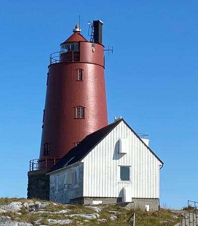
1917 (station established 1876). Active; focal plane 24 m (79 ft); white, red or green light depending on direction, occulting twice every 8 s. 19 m (62 ft) round cast iron tower with lantern and gallery, mounted on a stone base and attached to a 2-story keeper's house. The tower is painted red; the stone base is unpainted. A photo by Berit Harsvik Hauknes is at right, Trabas has Boucher's photo, the Lighthouse Association has a page for the lighthouse, another photo is available (first photo on the page), Wikimedia has a distant view from the sea, and Bing has a satellite view. According to the Lighthouse Association Seløy Kystferie offers occsasinal tours to the lighthouse. Located on a small island about 6 km (3.5 mi) southwest of Lovund and 15 km (9 mi) northwest of Solfjellsjøen on the island of Dønna. Accessible only by boat. Site open, tower closed. except for tours. . ARLHS NOR-290; NF-657300; Admiralty L2338; NGA 10140.
Jægtholmen
Date unknown. Active; focal plane 7 m (23 ft); white, red or green light depending on direction, occulting twice every 8 s. 7 m (23 ft) concrete post with lantern and gallery. Lighthouse painted white, lantern roof red. Google has a distant street view and Bing has a satellite view. Located on a skerry off the south coast of Dønna, in the narrow channel between Dønna and Skorpa. Accessible only by boat. Site open, tower closed. NF-614600; Admiralty L2175; NGA 9648.

Åsvær Light, Dønna, August 2021
Instagram photo by Berit Harsvik Hauknes

Leirfjord Lighthouses
Åkvikskjær
Date unknown. Active; focal plane 5 m (17 ft); white, red or green light depending on direction, occulting once every 6 s. 6 m (20 ft) concrete post with lantern and gallery. Lighthouse painted white, lantern roof red. No photo available but Google has a satellite view. Located on the south coast of Sundøy. Site open, tower closed. NF-616900; Admiralty L2188; NGA 9672.
Sandnes
Date unknown. Active; focal plane 8 m (26 ft); white, red or green light depending on direction, occulting twice every 8 s. 5 m (17 ft) concrete post with lantern and gallery. Lighthouse painted white, lantern roof red. No photo available but Google has a distant satellite view. Located on a headland at the northern end of the Leirfjord township. Site and tower closed (private property). NF-620800; Admiralty L2223; NGA 9716.

Nesna Lighthouses
Feøy
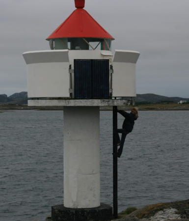
Date unknown. Active; focal plane 6.5 m (21 ft); white, red or green light depending on direction, occulting twice every 8 s. 5.5 m (18 ft) concrete post with lantern and gallery. Lighthouse painted white; lantern painted white with a red roof. Bash's photo is at right, Trabas has Siering's photo, and Google has a satellite view. Located on the western tip of the island of Feøy, about 5 km (3 mi) southwest of Nesna. Accessible only by boat. Site open, tower closed. NF-619500; Admiralty L2218; NGA 9700.
Sauragrunnen
Date unknown. Active; focal plane 7.5 m (25 ft); two flashes every 5 s, white, red or green depending on direction. 11 m (36 ft) concrete post with lantern and gallery. Lighthouse painted white with one black horizontal band; lantern painted white with a red roof. Trabas has Siering's photo and Google has a satellite view. Located on a skerry in the Lille Jonasfjord, about 2.5 km (1.5 mi) north of Nesna. Accessible only by boat. Site open, tower closed. NF-622900; Admiralty L2234.4; NGA 9748.
Handnesholmen
Date unknown. Active; focal plane 6.5 m (21 ft); white, red or green light depending on direction, occulting once every 6 s. 4 m (13 ft) octagonal lantern mounted on a stone foundation. Lantern painted white with a red roof. Trabas has Siering's photo, Bash has a photo, and Google has a satellite view. Located at the southwestern tip of a small island off the southwestern end of Handnesøya, about 1 km (0.6 mi) southwest of the Hannesøy ferry terminal. Accessible only by boat. Site open, tower closed. NF-624000; Admiralty L2236; NGA 9752.
Feøy Light
Feøy Light, Nesna, October 2010
Flickr Creative Commons photo by C.W. Bash

Information available on lost lighthouses:

Notable faux lighthouses:

Adjoining pages: North: Northern Helgeland | South: Southern Helgeland

Return to the Lighthouse Directory index | Ratings key

Posted August 3, 2006. Checked and revised July 25, 2023. Lighthouses: 28. Site copyright 2023 Russ Rowlett and the University of North Carolina at Chapel Hill.