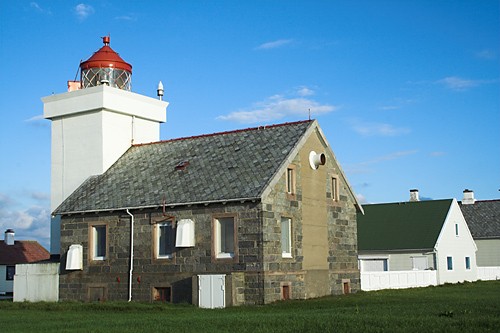
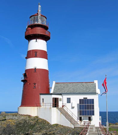
Lighthouses of Norway: Southern Rogaland (Eigersund Area)

The Kingdom of Norway (Norge in Norwegian) is one of the world's most maritime nations. The country is long and narrow with drowned valleys called fjords that bring the sea far inland in most regions. The mainland coast is estimated to be 2650 km (1650 mi) long and when all the islands and minor indentations are counted the total coastline approaches an astonishing 60,000 km (37,500 mi), long enough the go around the world one and a half times. With such a lengthy and rocky shore it's not surprising that Norway has a large number of lighthouses.

Norway is divided into counties (fylker) and the counties are divided into townships (kommuner). This page lists lighthouses of the southern portion of Rogaland County, including the townships of Sokndal, Eigersund, Hå, Klepp, and Sola. The coast of Rogaland faces southwest on the North Sea, directly opposite the Highlands of Scotland.

In Norwegian a lighthouse is a fyrtårn (fire tower) or simply a fyr; a fyrlykt is a beacon and a lyktehus is a lantern. Øy is an island, holmen is an islet, skjær is a skerry (a tiny island or rocky reef), sund is a strait (often between an island and the mainland), bukt is a bay, nes is a headland, and havn is a harbor.

Aids to navigation are maintained by the Kystverket (Coast Directorate), an agency of the Ministry of Transport and Communications.

ARLHS numbers are from the ARLHS World List of Lights. NF numbers are from the Norsk Fyrliste. Admiralty numbers are from volume B of the Admiralty List of Lights & Fog Signals. U.S. NGA List numbers are from Publication 115, but in 2018 NGA dropped many of its listings for the Norwegian fjords.

General Sources
Online List of Lights - Norway - South-West Coast
Photos by various photographers posted by Alexander Trabas; many of these photos were taken by Rainer Arndt, Michael Boucher, or Ronald Wöhrn.
Norwegian Lighthouse Association
News and photos from the Association.
Lighthouse Pages from Anke and Jens - Norway
Excellent photos of more than 60 Norwegian lighthouses.
Lighthouses in the Eigersund Area
Photos by various photographers available from Wikimedia.
World of Lighthouses - Norway
Photos by various photographers available from Lightphotos.net.
Norwegische Leuchttürme auf historischen Postkarten
Historic postcard images posted by Klaus Huelse.
Norsk Fyrliste
Current edition of the Norwegian light list.
Liste over Norske Fyr
From Norwegian Wikipedia, a handy list of Norwegian light stations with their dates of establishment.
GPSNauticalCharts
Navigational chart information for southern Norway.
Navionics Charts
Navigational chart for Rogaland.
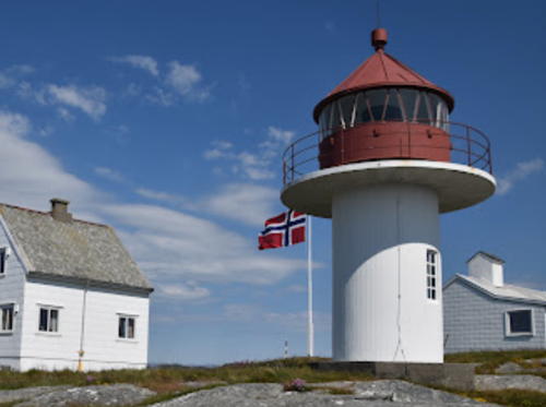
Eigerøy Fyr, Eigersund, August 2021
Google Maps photo by Sylwester G.
Sokndal Lighthouses
Vestre Kvalen (1)
Date unknown. Replaced and removed in 2018. This was a 5 m (16 ft) square skeletal tower, covered with siding, with lantern and gallery. Lighthouse painted white, lantern roof red. Trabas has Arno Siering's photo and Google has a satellite view. In 2018 the lighthouse was replaced by a light at a lower focal plane (focal plane 17 m (56 ft); red light, 2 s on, 2 s off). No photo of the new light is available. Perched on a cliff at the northwest side of the entrance to the Jøssingfjord about 5 km (3 mi) southeast of Hauge. The site appears quite inaccessible except by boat. Site open, tower closed. Current light: NF-091302; Admiralty B3150; ex-NGA 1900.
Alterodden
1895. Active; focal plane 8 m (26 ft); white, red or green light depending on direction, occulting once every 6 s. 4 m (13 ft) octagonal lantern mounted on a concrete pad. Trabas has Andreas Köhler's photo and Google has a satellite view. Lighthouse painted white with a red roof. Located on a promontory on the east side of the Rekefjord near the end of highway 40 about 8 km (5 mi) 5 km (3 mi) southwest of Hauge. Accessible only by boat. Site open, tower closed. ARLHS NOR-324; NF-092100; Admiralty B3160; ex-NGA 1924.
Lille Prestskjær (Lille Presteskjær)
1895. Active; focal plane 23 m (75 ft); white light, 1 s on, 1 s off. 21 m (69 ft) round cast iron tower with gallery, incorporating keeper's quarters, mounted on a circular stone base. The original lantern was removed and discarded when the lighthouse was automated in 1973; the present lantern is a replica. Tower painted with red and white horizontal bands. Stine Fekjær Skogly's 2020 photo is at right, Trond Hjønnevåg has a 2016 photo showing the new lantern, Odd Vinje has a 2022 photo, Trabas has a photo by Pauline and Wim de Kleine, the county has a 2015 photo, Lars Verket has a portfolio of photos, Geir Røsset has a distant view, and Google has a satellite view. Huelse has a 1903 postcard view showing the original appearance of the light. The lighthouse was vacant until the Midtbø family leased it from the Kystverket in 2001. The family has refurbished the interior and the lighthouse is now available through Airbnb for vacation rental or private parties. In 2009 the Midtbøs installed a replica lantern, although the active light is still mounted on the outside of the tower. Located on the west side of the entrance to the Rekefjord about 5 km (3 mi) southwest of Hauge. Accessible only by boat. Site open, tower open to guests. According to the Lighthouse Association there are occasional open house dates for public access. . ARLHS NOR-156; NF-092000; Admiralty B3156; NGA 1920.

Lille Presteskjær Fyr, Sokndal, July 2020
Instagram photo by Stine Fekjær Skogly

Eigersund (Egersund) Lighthouses
Eigersund was formed in 1965 by merging the former towns of Egersund and Helleland. The merged municipality is often called Egersund.
Svåholmene
Date unknown. Active; focal plane 22 m (72 ft); white flash every 3 s. 14 m (46 ft) skeletal platform atop a round stone cairn. Gunnar Liland has a photo and Google has an indistinct satellite view. Located off the small island Svåholmen, about 10 km (6 mi) southeast of Egersund. Accessible only by boat. Site open, tower closed. NF-092900; Admiralty B3172; ex-NGA 1940.
* Vibberodden (1)
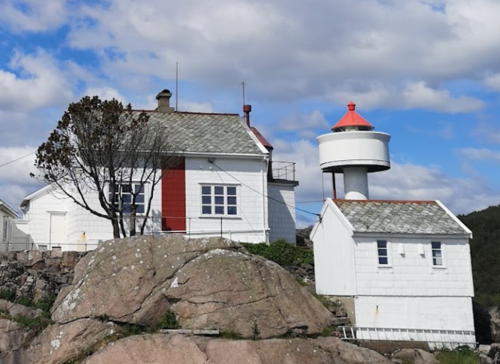
1855. Inactive since 1977. 9 m (30 ft) square cylindrical wood tower with lantern and gallery, set into the front of a 1-1/2 story wood keeper's house. Building painted white, lantern and gallery red. This lighthouse marks the west side of the entrance to a narrow fjord leading to Egersund. The house has apparently been vacant since 1977. A photo by Tom Raknes is at right, Trabas has a photo by Pauline and Wim de Kleine, Andreas Köhler has a 2019 photo, and Google has a satellite view. In late 2005 or early 2006 the lighthouse was leased to a new foundation established by the Egersund Coastal Society, Nordfjord Folk Museum and the municipality of Eigersund. The foundation restored the building and in 2015 a pedestrian bridge was built to connect the light station to the mainland. The friends group tiftelsen Vibberoddens Venner manages the station and rents it for overnight guests. Located at the southeast point of Eigerøy about 8 km (5 mi) south of Eigersund by road. Site open, tower closed. Site manager: Vibberodden Fyrstasjon . ARLHS NOR-274.
* Vibberodden (2)
1977 (station established 1855). Active (?); focal plane 22 m (72 ft); white, red or green light depending on direction, occulting once every 6 s. 8 m (26 ft) concrete post with lantern and gallery. Lighthouse painted white; lantern roof painted red. Located adjacent to the historic lighthouse. Site open, tower closed. ARLHS NOR-346; NF-093500; Admiralty B3176; ex-NGA 1948.


Vibberodden Fyr, Eigersund, June 2020
Google Maps photo by Tom Raknes

** Eigerøy
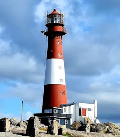
1854. Active; focal plane 46 m (151 ft); three white flashes every 30 s. 33 m (108 ft) round cast iron tower with lantern and gallery, attached to a 2-story service building. 1st order Fresnel lens in use. Lighthouse painted red with one white horizontal band. A lovely 2021 photo is at the top of this page, Wikimedia has Roar Johansen's photo, Anke and Jens have several good photos, Trabas has Arno Siering's closeup photo, and Google has a street view and a satellite view. This was Norway's first cast iron lighthouse and its success encouraged the building of many more on the Norwegian coastline. Automated in 1989, the lighthouse remains under the control of the Kystverket, but Eigersund Kommune manages the rest of the station. During the summer the keeper's house is available for overnight accommodations during the week, but on Sundays it is a visitor center and coffee bar. Located on Midbrødøya, an island just off the southwestern tip of Eigerøy, about 12 km (7.5 mi) west of Egersund. Accessible by road. Parking is provided; it's about a 30 minute walk on the gated access road to reach the lighthouse. Site open, tower open for climbing on Sundays mid June through mid August. Site manager: Eigersund Kommune. . ARLHS NOR-010; NF-094500; Admiralty B3184; NGA 1960.
Ruskodden
Date unknown. Active; focal plane 15 m (49 ft); white, red or green light depending on direction, occulting twice every 8 s. 6 m (20 ft) lantern on a platform supported by four piles. Lantern painted white with a red roof, piles black. Trabas has Andreas Köhler's photo and Google has a satellite view. Located at the northwestern tip of Eigerøy, marking the entrance to the Furasund. NF-094600; Admiralty B3186; NGA 1964.
Grunnsundholmen (Furasund, Grunnesundsholmen) (2?)
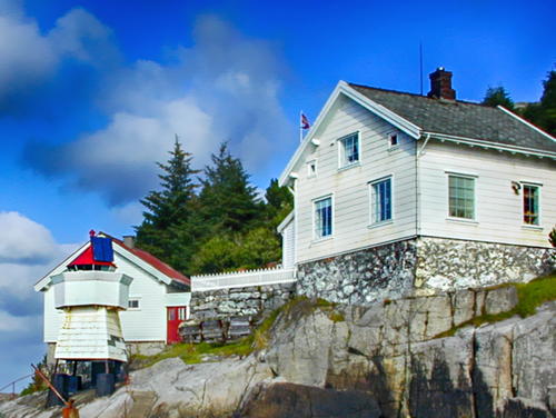
1928(?) (station established 1855). Inactive since 2015. 6 m (20 ft) square wood tower with lantern and gallery. Lighthouse painted white; lantern roof is red. The 1-1/2 story wood house adjoining the lighthouse is the former keeper's house, but we need more information on the history of this station. The house is now a private residence. Ole Rødland has a 2002 photo is at right, Leif Rødland has a 2017 sunset photo of the light, and Google has a satellite view. Located on a small island in the Furasund, on the northwest side of Eigerøy. Accessible only by boat. Site status unknown. ARLHS NOR-101; ex-NF-094700; ex-Admiralty B3188; ex-NGA 1968.


Grunnsundholmen Fyr, Eigersund, July 2002
Google Maps photo by Ole Rødland


Hå Lighthouses
Sirevåg (Persodden)
Date unknown. Inactive. 5.5 m (18 ft) lantern mounted on a concrete stand. The active light (focal plane 13.5 m (48 ft); continuous red light) has been moved to a post. Lantern painted white with a red roof, stand black. Ole Voll has a 2020 closeup photo and Google has a satellite view. Located on a headland above the wharf area of Sirevåg. Site status unknown. Active light: NF-097902; Admiralty B3215.5.
Rauna
Date unknown. Active; focal plane 10.5 m (34 ft); white flash every 5 s. 8 m (26 ft) stone cairn topped by a white fiberglass beacon. 1-story keeper's cottage. Trabas has a Arno Siering's distant view, Konstantin Schäfer also has a distant view, and Google has a satellite view. Located on a small island in the Ognabukta bight south of Hå. Accessible only by boat. Site status unknown. NF-098300; Admiralty B3216; NGA 2048.
**** Kvassheim (1)
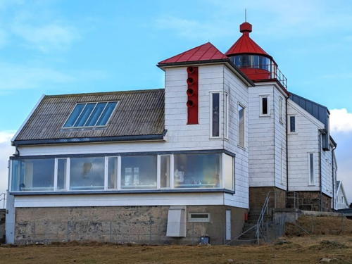
1912. Inactive since 1990. 12 m (39 ft) lantern and gallery centered on the roof of a 1-1/2 story wood keeper's house. Building painted white, lantern red. 1-1/2 story assistant keeper's house and several other buildings are preserved at this station. Oleksandr Bashyn's 2024 photo is at right, Ivan Mæland has a 2021 photo, Anke and Jens also have a good photo, Heidi Karlsen has a 2022 photo that also shows the current light, Jarle Vines has a good 2007 photo, and Google has a street view and a satellite view. In 2003 management of the station was transferred to the Jæren Friluftsråd (Recreation Council), which began restoration work the following winter. The keeper's house is a museum and the fog signal building has been renovated as a café. The assistant keeper's house provides accommodations for groups of 8-12 (no single rooms). Located on a promontory just off highway 44 about 2.5 km (1.5 mi) south of Vigrestad. Site open, museum, lighthouse and tower open daily late June to mid August and on Sundays and holidays during the rest of the year except December. Site manager: Jæren Friluftsråd (Friluftsfyret Kvassheim ). ARLHS NOR-026.
* Kvassheim (2)
1990. Active; focal plane 11 m (36 ft); white, red or green light depending on direction, occulting twice every 8 s. 6 m (20 ft) concrete post with lantern and gallery, painted with red and white horizontal bands. Trabas has Arno Siering's closeup photo, Jan-Egil Trobe has a 2021 photo, Anke and Jens have a photo, and Google has a street view and a satellite view. Located a short distance west of the historic lighthouse. ARLHS NOR-333; NF-098600; Admiralty B3217; NGA 2052.

Kvassheim Fyr, Hå, January 2024
Google Maps photo by Oleksandr Bashyn
* [Obrestad Havn]
Date unknown. Active; focal plane 4 m (13 ft); white, red or green light depending on direction, occulting once every 6 s. 3 m (10 ft) octgonal lantern, painted white with a red roof. Fred Rune Nilsen has a 2024 photo, Anne Gro Kristensen has a view across the harbor, and Google has a street view and a satellite view. Located at a small boat harbor about 800 m (1/2 mi) southwest of the Obrestad lighthouse. Site open, tower closed. ARLHS NOR-336; NF-099100; Admiralty B3222; NGA 2060.
**** Obrestad (2)
1873 (light tower added in 1950). Active; focal plane 39 m (128 ft); continuous white light with a more intense flash every 30 s. 16 m (52 ft) square cylindrical granite tower with lantern and gallery, attached to the landward end of a 1-1/2 story granite keeper's house. Lighthouse painted white, lantern red. The light formerly served as the rear light of a range with the Håtangen light (next entry) as the front light. Roar Johansen's photo appears at right, Trabas has Arno Siering's closeup photo, Anke and Jens have good photos, Wikimedia has additional photos, Geert Premereur has a 2021 closeup, Jan Inge Dalsbø has a fine 2008 closeup, and Google has a street view and a satellite view. Huelse has a postcard view showing the original appearance of the lighthouse; the present light tower was added in 1950. The station also includes a principal keeper's house built in 1905 as well as other buildings. Hå Kommune purchased the light station in 2006; there is a museum in the lighthouse and the keeper's house is available for private functions or overnight accommodations. Located on a promontory about 5 km (3 mi) west of Nærbø. Site open; museum and tower open daily mid June through mid August and on Sundays March-June and August-December. Owner: Hå Kommune; site manager: Obrestad Fyr . ARLHS NOR-034; NF-099000; Admiralty B3220.1; NGA 2056.
Obrestad Fyr
Obrestad Fyr, Hå, September 2006
Wikimedia Creative Commons photo by Roar Johansen
* Håtangen (Obrestad Range Front)
1903. Active; focal plane 8 m (26 ft); white light occulting once every 6 s; the light is intensified on a range line with the Obrestad lighthouse. 4 m (13 ft) lantern mounted on four iron legs on a concrete base. Lantern painted white with a red roof. Wikimedia has Roar Johansen's photo, Trabas has Michael Boucher's closeup, and Google has a satellite view and a very distant street view. Located at the small harbor of Obrestad about 5 km (3 mi) west of Nærbø and 1 km (0.6 mi) southeast of the Obrestad lighthouse. Site open, tower closed. NF-099400; Admiralty B3220; NGA 2064.

Klepp Lighthouse
Feistein
1859. Active; focal plane 34 m (112 ft); continuous white light with two more intense flashes every 20 s; also a red or green light, depending on direction, 3 s on and 3 s off, at a focal plane of 21 m (69 ft). 25 m (82 ft) round cast iron tower with lantern and gallery attached to a 2-story keeper's house. Lighthouse painted red with two white horizontal bands below the gallery. A second 1-1/2 story keeper's house is connected to the tower by a raised walkway. Kari Nybakk's 2022 photo is at right, Trabas has a good photo by Ronald Wöhrn, Wikimedia has several views from the sea, Zydrunas Liutkevicius has a photo, Cevdet Omer has a 2017 photo, Klepp Kommune has a good photo, and Google has a satellite view. A friends group, the Feistein Fyr Venneforening , helps maintain the lighthouse. The keepers houses are available for overnight accommodations. Located on an island about 2 km (1.2 mi) off the coast near Verdalen. Accessible only by boat. Site open, tower closed. Site manager: Klepp Kommune (Feistein Fyr ). ARLHS NOR-013; NF-100000; Admiralty B3228; NGA 2068.

Sola Lighthouses
Kolnesholmane
1913. Active; focal plane 18 m (59 ft); flash every 5 s, white, red or green depending on direction. 13 m (43 ft) post with a small lantern and gallery. Lighthouse painted white; lantern roof is red. Trabas has Wöhrn's photo and Google has a satellite view. Located on an island about 1.5 km (1 mi) off the coast near Sola. Accessible only by boat. Site open, tower closed. ARLHS NOR-331; NF-100200; Admiralty B3232; NGA 2076.


Feistein Fyr, Klepp, May 2022
Instagram photo by Kari E. Nybakk

Flatholmen (Fladholmen) (3)
1957 (station established 1862). Active; focal plane 18 m (59 ft); white, red or green light, occulting once every 6 s. 8 m (26 ft) post light with a small lantern and gallery. The station includes at least two 1-1/2 story keeper's houses and several other buildings. Len Duevel's 2023 photo is at right, Trabas has a photo by Ronald Wöhrn, Jan Erik Samsonsen has a 2021 closeup photo, a 2017 photo and a 2009 view from the sea is available, and Google has a satellite view. The buildings were restored in 2010 but a lease on the station expired in 2021. In 2023 Sola Kommune leased the station and subleased it to a new friends group, the Flatholmen Fyrs Venner. The group plans to restore the buildings for overninght accommodations. Located on an island about 1 km (0.6 mi) off the coast at Tananger. Accessible only by boat; transportation to the island can be arranged in Tananger. Site open, tower closed. Owner: Kystverket. Lessee: Sola Kommune. Site manager: Flatholmen Fyrs Venner . ARLHS NOR-083; NF-100500; Admiralty B3236; NGA 2084.
* [Tananger]
1890. Active; focal plane 14 m (46 ft); white, red or green light, depending on direction, occulting three times every 10 s. 3 m (10 ft) lantern mounted on a concrete pad, painted white with a red roof. Trabas has a closeup photo by Michael Boucher and Google has a satellite view. Located off the Havneveien on the east side of the entrance to the harbor of Tananger, close to the pilot station. Site open, tower closed. ARLHS NOR-342; NF-100600; Admiralty B3237; NGA 2088.
Oksefotskjær (Oksafodskjær)
Date unknown. Active; focal plane 10 m (33 ft); flash every 5 s, white, red or green depending on direction. 10 m (33 ft) post with a small lantern and gallery. Lighthouse painted white; lantern roof is red. Trabas has Arno Siering's photo and Google has a satellite view. Located on an island about 1.5 km (1 mi) off the coast northwest of Tananger. Accessible only by boat. Site open, tower closed. ARLHS NOR-338; NF-100900; Admiralty B3241; NGA 2100.

Flatholmen Fyr, Sola, June 2023
Google Maps photo by Len Duevel

Information available on lost lighthouses:

Notable faux lighthouses:

Adjoining pages: North: Stavanger Area | East: Vest-Agder (Kristiansand Area)

Return to the Lighthouse Directory index | Ratings key

Posted May 15, 2006. Checked and revised June 5, 2024. Lighthouses: 20. Site copyright 2024 Russ Rowlett and the University of North Carolina at Chapel Hill.