Lighthouses of Norway: Central Rogaland (Stavanger Area)

The Kingdom of Norway (Norge in Norwegian) is one of the world's most maritime nations. The country is long and narrow with drowned valleys called fjords that bring the sea far inland in most regions. The mainland coast is estimated to be 2650 km (1650 mi) long and when all the islands and minor indentations are counted the total coastline approaches an astonishing 60,000 km (37,500 mi), long enough the go around the world one and a half times. With such a lengthy and rocky shore it's not surprising that Norway has a large number of lighthouses.

Norway is divided into counties (fylker) and the counties are divided into townships (kommuner). This page lists lighthouses of the Stavanger area in central Rogaland County, including the fjords extending to the east and northeast of Stavanger. Lighthouses of the southern part of Rogaland are on the Eigersund Area page, and those of the northern area are on the Haugesund Area page.

In Norwegian a lighthouse is a fyrtårn (fire tower) or simply a fyr; a fyrlykt is a beacon and a lyktehus is a lantern. Øy is an island, holmen is an islet, skjær is a skerry (a tiny island or rocky reef), sund is a strait (often between an island and the mainland), bukt is a bay, nes is a headland, and havn is a harbor.

Aids to navigation are maintained by the Kystverket (Coast Directorate), an agency of the Ministry of Transport and Communications.

ARLHS numbers are from the ARLHS World List of Lights. NF numbers are from the Norsk Fyrliste. Admiralty numbers are from volume B of the Admiralty List of Lights & Fog Signals. U.S. NGA List numbers are from Publication 115. In 2018 NGA dropped many of its listings for the Norwegian fjords.

General Sources
Online List of Lights - Norway North Sea
Photos by various photographers posted by Alexander Trabas; for this area many of the photos were taken by Ronald Wöhrn, Rainer Arndt, Michael Boucher, or Sigurd Vermundsen.
Norwegian Lighthouse Association
News and photos from the Association.
Lighthouse Pages from Anke and Jens - Norway
Excellent photos of more than 60 Norwegian lighthouses.
Lighthouses in Stavenger Area
Photos by various photographers available from Wikimedia.
World of Lighthouses - Norway
Photos by various photographers available from Lightphotos.net.
Norwegische Leuchttürme auf historischen Postkarten
Historic postcard images posted by Klaus Huelse.
Norsk Fyrliste
Current edition of the Norwegian light list.
Liste over Norske Fyr
From Norwegian Wikipedia, a handy list of Norwegian light stations with their dates of establishment.
GPSNauticalCharts
Navigational chart information for Rogaland.
Navionics Charts
Navigational chart for Rogaland.


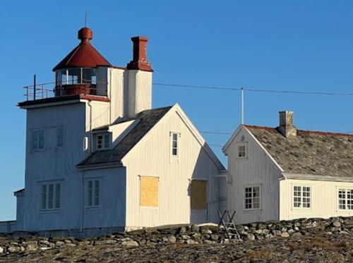
Tungenes Light, Randaberg, January 2024
Google Maps photo by Ingeborg T

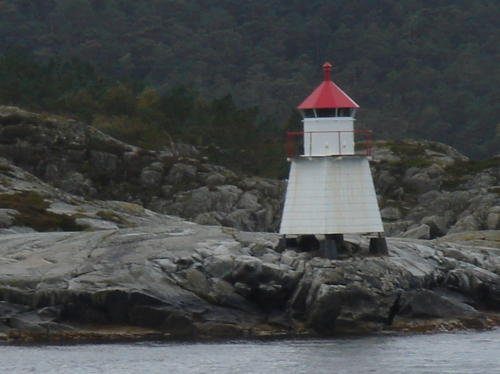
Tingholmen Light, Stavanger, September 2007
Wikimedia Creative Commons photo by Joseaperez

Lighthouses of Stavanger Harbor and Its Approaches

Kvitsøy Lighthouses
The Kvitsøy township occupies a small group of islands about 8 km (5 mi) west of the entrance to Stavanger's harbor. There is a town (Ydstebøhavn) on the largest island and ferry service is available daily from Stavanger. Kvitsøy will become accessible by the ambitious Rogfast tunnel project, to be completed by the early 2030s.

Gjerdholmen (2)
Date unknown. Active; focal plane 8 m (26 ft); white, red or green light, depending on direction (this light has 16 sectors), 3 s on, 3 s off. 6 m (20 ft) round fiberglass tower with lantern and gallery. Lighthouse painted white; lantern roof painted red. A 2011 photo is available and Google has a satellite view. Rainer Schütz has a 1999 photo of the previous lighthouse, a square wood tower, and Trabas has a very distant photo. Located on a small island off the southeast coast of Kvitsøy. ARLHS NOR-353; NF-103800; Admiralty B3252; NGA 2148.
Sandholmen
Date unknown. Active; focal plane 7 m (23 ft); white, red or green light, depending on direction, 1 s on, 1 s off. 6 m (20 ft) lantern on a platform supported by piles. Lighthouse painted white; lantern roof painted red. No photo available but Google has a satellite view. Located on a small island off the east coast of Kvitsøy. NF-104300; Admiralty B3253; NGA 2160.
Piggskjeret
Date unknown. Active; focal plane 6 m (20 ft); white, red or green light, depending on direction, 2 s on, 2 s off. 5.5 m (18 ft) square tower with lantern and gallery. Lighthouse painted white; lantern roof painted red. No photo available but Google has a satellite view. Located on a small island about 1.6 km (1 mi) south of Kvitsøy. NF-104400; Admiralty B3254; NGA 2168.
** Kvitsøy (2)
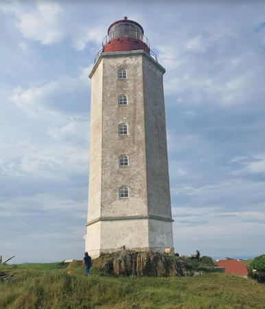
1829 (station established 1700). Active; focal plane 45 m (148 ft); four white flashes every 40 s. 27 m (89 ft) octagonal stone tower with lantern and gallery. 2nd order Fresnel lens in use. Tower painted white, lantern red. Hanne Svendsen's 2020 photo is at right, Trabas has Wöhrn's photo, Kalev Kavad has a 2010 photo and also a December 2008 photo, Wikipedia's page has a photo, and Google has a street view and a satellite view. This is the oldest active lighthouse in Norway. The first light was a "bucket light" displayed from a mast. (In 2005, a replica of this light was built next to the lighthouse.) The 1829 lighthouse had a height of 18 m (59 ft); the tower was extended by 7 m (23 ft) in 1859 and gained another 2 m (7 ft) when a first order lantern was installed in 1910. The tower was designed to incorporate keeper's quarters, but the Lighthouse Association page says the interior is "relatively bare" today. The lighthouse is located near the west end of the island in the village of Kvitsøy. Site open; lighthouse open to guided tours on request; check the web site for a phone number to call for reservations. Site manager: Kvitsøy Kommune (Kvitsøy Fyr ). ARLHS NOR-146; NF-102000; Admiralty B3246; NGA 2108.
Kalveneset (2)
Date unknown. Active; focal plane 16 m (52 ft); one long flash every 10 s, white, red or green, depending on direction. 10 m (33 ft) round fiberglass lantern on a platform supported by four concrete piles. The previous light was a lantern on a concrete post. Lighthouse painted white; lantern roof painted red. Trabas has Arndt's photo and Google has a satellite view. Located on a skerry off the northwestern tip of Kvitsøy. NF-104500; Admiralty B3255; NGA 2180.

Kvitsøy Light, Kvitsøy, June 2020
Google Maps photo by Hanne Svendsen

Randaberg Lighthouses
**** Tungenes
1828. Inactive since 1984. Approx. 12 m (39 ft) square cylindrical tower rising from the seaward side of a 1-1/2 story keeper's house. 4th order Fresnel lens mounted in the lantern. Lighthouse painted white; lantern roof is red. Other station buildings include a 2-story principal keeper's house (1938) and a 1-1/2 story assistant keeper's house (1958). A 2024 photo is at the top of this page, Anke and Jens have a page with photos, L.C. Nøttaasen has a 2011 closeup, Cbull Gjertsen has a 2008 photo, Wikimedia has additional photos, Huelse has a historic postcard view, and Google has a street view and a satellite view. The lighthouse was deactivated in favor of the Bragen light (next entry) offshore. The station has been fully restored to its 1930s appearance; it serves as a fine arts center and lighthouse and maritime museum. One of the buildings houses a café. The lighthouse marked the cape at the south side of the entrance to Stavanger harbor. Located at the end of the Tungenesveien on the west side of Randaberg. Site open; museum and tower open in the afternoons daily mid June through August and on Sundays March through mid June and September through November. Owner: Randaberg Kommune. Site manager: Jærmuseet (Tungenes Fyr ). ARLHS NOR-048.
Bragen
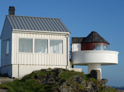
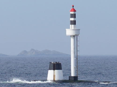
1984. Active; focal plane about 17 m (56 ft); white, red or green light, depending on direction, occulting once every 6 s. Approx. 16 m (52 ft) concrete post topped by a fiberglass tower. The fiberglass extenion is colored with black and white horizontal bands and has a red roof; the rest of the lighthouse is painted white. Andreas Nielsen has the 2024 photo of the newly-extended light seen at right. Trabas has Arndt's photo showing the original lantern on the post, another photo is available, and Google has a satellite view. The photos show an older stone beacon next to the modern light; we don't know if this was always a daybeacon or if it was ever a lighted aid. This light replaced the historic Tungenes lighthouse; it is located on a tiny island about 800 m (1/2 mi) northwest. Accessible only by boat. Site and tower closed. ARLHS NOR-297; NF-105500; Admiralty B3262; NGA 2196.

Fjøløy Light, Rennesøy, March 2024
Google Maps photo by Andreas Nielsen

Stavanger Lighthouses
* Dusiviga (Dusavika, Vardeneset) (3)
1914 (station established 1865). Active; focal plane 5 m (17 ft); white, red or green light, depending on direction, occulting once every 6 s. 4 m (13 ft) lantern painted white with a red roof and mounted on a round rubblestone base. Trabas has Arndt's closeup photo, Gard Karlsen has a 2021 photo, and Google has a satellite view. Located off the Dusavikveien in Stavanger, marking the entrance to the Åmøfjord, which forms the city's inner harbor. Site open, tower closed. . ARLHS NOR-328; NF-105900; Admiralty B3266; NGA 2204.
* Valbergtårnet
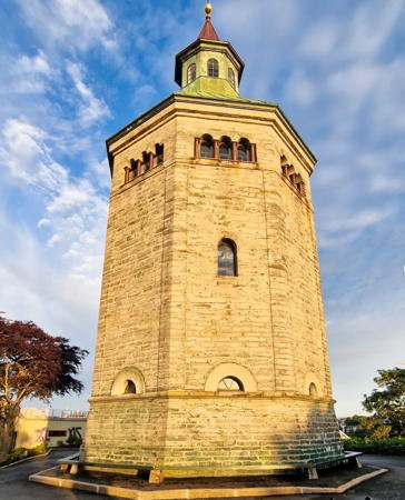
1863. Inactive since 1865. 26.5 m (87 ft) octagonal stone watchtower with a pyramidal copper roof and cupola. Wivian Steen's 2022 photo is at right, Phillip Partridge has a photo, Wikimedia has another good photo, and Google has a street view and a satellite view. This historic tower, a well-known landmark in Stavanger, was completed in 1853 and used only briefly as a lighthouse. Until 1922 watchmen manned the tower to warn of fires. The building now houses a small museum. Located on the Valberggata, on the east side of Stavanger's traditional harbor. Site open, tower status unknown. Owner/site manager: Stavanger Kommune (Valbergtårnet ).
Pannevigodden (Pannevikodden)
Date unknown. Active; focal plane 5 m (17 ft); white, red or green light, depending on direction, occulting twice every 8 s. Lantern, painted white with a red roof and mounted on a platform supported by four piles. Trabas has Jim Smith's photo, another photo and a distant view are available, and Google has a satellite view. Located on the tip of a promontory on the east side of Stavanger, marking the entrance to the Gansfjord. Site open, tower closed. NF-107700; Admiralty B3280; NGA 2268.
Åmøy
Date unknown. Active; focal plane 5 m (17 ft); white, red or green light, depending on direction, occulting once every 6 s. 6 m (20 ft) lantern, painted white with a red roof and mounted on a platform supported by four piles. Trabas has Andreas Köhler's closeup photo and Google has a satellite view. Located on the northeastern tip of Austre Åmøy, an island northeast of Stavanger. Site open, tower closed. NF-110600; Admiralty B3309; NGA 2332.

Rennesøy Lighthouses
Linesund
Date unknown. Active; focal plane 4 m (13 ft); white, red or green light, depending on direction, occulting once every 6 s. 4 m (13 ft) lantern mounted on a rubblestone base, painted white with a red roof. Trabas has Andreas Köhler's photo and Google has a good satellite view and a distant street view. Located on a skerry in the Linesund, a narrow passage between the islands of Sokn and Åmøy. Accessible only by boat. Site open, tower closed. NF-111000; Admiralty B3311; NGA 2348.

Valbergtårnet, Stavanger, June 2022
Instagram photo by Wivian Steen
Gryda
1914. Active; focal plane 6 m (20 ft); white, red or green light, depending on direction, 1 s on, 1 s off. 6 m (20 ft) tripod tower with a fiberglass lantern and gallery. Lantern painted white with a red roof. Trabas has Arndt's photo and Google has a satellite view. Located in the Kvitsøyfjord about 1.5 km (1 mi) northeast of the Tungenes lighthouse. Accessible only by boat. Site and tower closed. ARLHS NOR-329; NF-105600; Admiralty B3264; NGA 2200.
* Fjøløy (3)
1954 (station established 1849). Active; focal plane 17 m (56 ft); white, red or green light, depending on direction, occulting twice every 8 s. 7 m (23 ft) post light with a small lantern and gallery. Lighthouse painted white; lantern roof is red. A 1-story keeper's house survives at this site, but it may be endangered by lack of maintenance. The original lighthouse was replaced in 1867. Andreas Nielsen's 2024 photo is at right, Trabas has Boucher's photo, Jan Willi Talgø has a 2021 sunset photo, Wikimedia has Roar Johansen's photo, a good 2008 photo is available, Johannes Carlsen has a closeup of the lantern, Trond Olsen has a closeup street view, and Google has a satellite view. Located on the southwest side of Fjøløy, an island directly across the Kvitsøyfjord from the Tungenes lighthouse. The island is accessible from Stavanger by the Byfjord Tunnel and a series of bridges. Site open, tower closed. . ARLHS NOR-081; NF-104800; Admiralty B3258; NGA 2188.
Mastrafjord
Date unknown. Active; focal plane 4.5 m (15 ft); white, red or green light, depending on direction, occulting once every 6 s. 5 m (17 ft) lantern mounted on a rubblestone base, painted white with a red roof. No photo available but Google has a satellite view. Located on the northwestern point of Klosterøy. Site status unknown. NF-111700; Admiralty B3315; NGA 2376.

Fjøløy Light, Rennesøy, June 2024
Google Maps photo by Andreas Nielsen

Lighthouses of Fjords East and Northeast of Stavanger

Sandnes Lighthouse
Tingholmen
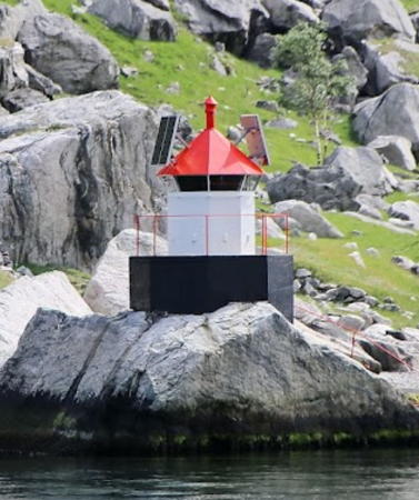
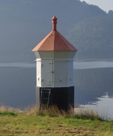
Date unknown. Active; focal plane 8 m (25 ft); white, red or green light, depending on direction, occulting twice every 8 s. 6 m (20 ft) square pyramidal tower with lantern. Lighthouse painted white; lantern roof is red. Wikimedia's photo is at the top of this page, Trabas has a photo by Günther Hess, Claudio Naso has a view from the fjord, and Google has a satellite view. Located on an island on the south side of the entrance to the Høgsfjord about 5 km (3 mi) northeast of Hommersåk and 8 km (5 mi) by sea east of Stavanger. Accessible only by boat. Site status unknown. ARLHS NOR-343; NF-108200; Admiralty B3288; NGA 2276.

Forsand Lighthouse
Geitanes
Date unknown. Active; focal plane 5 m (17 ft); flash every 5 s, white, red or green depending on direction. 4.5 m (15 ft) lantern mounted on a round stone base. Lantern painted white with a red roof. Mark Koenig's photo is at right, a closeup is available, and Bing has an indistinct satellite view. Located on a reef in the Lysefjord about 3 km (2 mi) west of Lysebotn. Accessible only by boat, but easily seen from ferries on this very scenic fjord. Site open, tower closed. NF-109000; Admiralty B3298; ex-NGA 2296.
Lysefjorden
Date unknown. Active; focal plane 7 m (23 ft); white, red or green light, depending on direction, 3 s on, 3 s off. 6 m (20 ft) square wood tower with lantern and gallery. Lighthouse painted white; lantern roof is red. No photo available but Google has a satellite view. Located on the north side of the Lysefjord about 1.2 km (3/4 mi) east of the Songesand ferry terminal. Site open, tower closed. NF-108800; Admiralty B3296; ex-NGA 2292.

Strand Lighthouses
Håhammaren
Date unknown. Active; focal plane 8.5 m (28 ft); white, red or green light, depending on direction, occulting once every 6 s. 4 m (13 ft) lantern mounted on a stone base. Lantern painted white with a red roof. No photo available but Google has a satellite view. Located on a headland about 1.2 km (3/4 mi) south of Jørpeland. Site open, tower closed. NF-109900; Admiralty B3306; ex-NGA 2312.
Kvernanes (Tau)
Date unknown. Active; focal plane 5 m (17 ft); white, red or green light, depending on direction, occulting once every 6 s. 6 m (20 ft) lantern mounted on tripod piles. Lantern painted white with a red roof. Lightphotos.net has a photo, another closeup photo is available, and Google has a distant satellite view. Located off a headland on the north side of the entrance to the harbor of Tau, an important ferry terminal. Accessible only by boat, but easily seen from ferries arriving from Stavanger. Site open, tower closed. NF-111800; Admiralty B3318; NGA 2380.

Geitanes Light, Forsand, June 2018
Google Maps photo by Mark Koenig

Hjelmeland Lighthouses
Langholmen
Date unknown. Active; focal plane 5 m (17 ft); white, red or green light, depending on direction, occulting once every 6 s. 5.5 m (18 ft) lantern mounted on a stone base. Lantern painted white with a red roof. Andreas Nielsen has a photo (a portion is seen at right) and Google has a satellite view. Located on an island in the entrance to the Årdalsfjord. Site open, tower closed. NF-112500; Admiralty B3332; ex-NGA 2400.
Ølesund
Date unknown. Active; focal plane 9.5 m (31 ft); white, red or green light, depending on direction, occulting once every 6 s. 6.5 m (21 ft) square wood tower with lantern and gallery. Lighthouse painted white; lantern roof is red. Google has a street view from the Randøy bridge and Google has an indistinct satellite view. Located at the village of Ølesund, on Randøy about 800 m (1/2 mi) north of the bridge. Site status unknown. NF-112800; Admiralty B3334; ex-NGA 2404.

Finnøy Lighthouses
* Talgje
1904. Active; focal plane 6 m (20 ft); white, red or green light, depending on direction, occulting once every 6 s. 6 m (20 ft) lantern and gallery mounted on four straight piles. Lantern painted white with a red roof, piles painted black. A small photo is available (at the bottom of the page) and Google has a street view and a satellite view. Talgje is an island in the Hillefjord about 12 km (7.5 mi) northeast of Stavanger. Located at the southeastern tip of the island. Site open, tower closed. NF-112000; Admiralty B3322; NGA 2388.

Langholmen Light, Hjelmeland, June 2013
Google Maps photo by Andreas Nielsen
Helgøysund
Date unknown (station established 1888). Active; focal plane 6 m (20 ft); white, red or green light, depending on direction, occulting once every 6 s. 6 m (20 ft) concrete post with lantern and gallery. Lighthouse painted white; lantern roof is red. The light is at the left edge of Kjell Augestad's photo and Google has a satellite view. Located on the eastern tip of Talge (not the same as Talgje), a short distance south of the bridge linking Talge to the neighboring island of Nedsttun. Accessible only by boat. Site open, tower closed. NF-114000; Admiralty B3354; NGA 2444.
Ombo
Date unknown. Active; focal plane 19.5 m (64 ft); white, red or green light, depending on direction, 1 s on, 1 s off. 6 m (20 ft) square wood tower with lantern and gallery. Lighthouse painted white; lantern roof is red. No photo available but Google has a satellite view. Located on a headland on the northwest side of the large island of Ombo. Site status unknown. NF-113900; Admiralty B3350; ex-NGA 2440.

Suldal Lighthouses
Barkeneset (2)
Date unknown. Active; focal plane 7.5 m (25 ft); white, red or green light, depending on direction, 2 s on, 2 s off. 6.5 m (21 ft) tower with lantern and gallery. Lighthouse painted white; lantern roof is red. No photo available but Google has a fuzzy satellite view and a very distant street view. Formerly onshore with a focal plane of 14 m (46 ft), this light has been moved out into the fjord. Located just off a headland on the northwest side of the entrance to the Økstrafjord from the Jelsafjord, about 5 km (3 mi) east of Jelsa. Site status unknown. NF-113000; Admiralty B3339; ex-NGA 2412.
Ottøya
Date unknown. Active; focal plane 28 m (92 ft); white, red or green light, depending on direction, occulting once every 6 s. 6 m (20 ft) square wood tower with lantern and gallery. Lighthouse painted white; lantern roof is red. No photo available but Google has a distant satellite view. Located atop a cliff at the north end of Ottøy, opposite Marvik. Site status unknown. NF-115300; Admiralty B3376; ex-NGA 2480.
#Hamborneset (Hamborgneset) (1)
Date unknown. Replaced in 2018. This was a 6 m (20 ft) square pyramidal tower with lantern and gallery. Lighthouse painted white; lantern roof painted red. Sven Voldum has a photo and Google has a satellite view of the location. The light was replaced by a small post light (focal plane 6 m (20 ft); continuous green light). Located at a bend in the Sandfjord, on the south side of the fjord, about 8 km (5 mi) southwest of Sand. Site open, tower closed. ex-NF-115800; ex-NGA 2492. Active light: NF-115877; Admiralty B3384.
Eidsneset (Eidsnes)
Date unknown. Active; focal plane 6 m (20 ft); white, red or green light, depending on direction, occulting once every 6 s. 6 m (20 ft) square wood tower with lantern and gallery. Lighthouse painted white; lantern roof is red. No photo available but Google has an indistinct satellite view. Located at Eide, about 1.2 km (3.4 mi) north of the ferry terminal at Sand. Site status unknown. NF-116300; Admiralty B3388; ex-NGA 2500.
Dragsneset (2)
Date unknown. Active; focal plane 8 m (26 ft); white, red or green light, depending on direction, 3 s on, 3 s off. 6.5 m (21 ft) fiberglass tower with lantern colored white with two black horizontal bands; lantern roof is red. No photo available but Google has a satellite view. This light replaced a square wood tower with lantern and gallery just barely visible in Trabas's very distant view. Located at the extreme northwest corner of Suldal Kommune, marking the junction of the Vindafjord and the Krossfjord. Site status unknown. NF-117700; Admiralty B3400; ex-NGA 2536.

Sauda Lighthouses
* Saudnes (Saunes)
Date unknown. Inactive since 2018 (a solar-powered decorative light is displayed). 4.5 m (15 ft) octagonal lantern standing on an octagonal concrete base. Lantern painted white; lantern roof is red. Egil Knutsen's closeup photo is at right, Trabas has Arno Siering's photo and Google has the 2019 street view seen at right and a distant satellite view. The local motorboat club has taken ownership of the lighthouse. Located at the base of a headland about 2.5 km (1.5 mi) southwest of Sauda. Accessible by road. Site open, tower closed. Site manager: Sauda Motorbåt Forening. ex-NF-116700; ex-Admiralty B3394; ex-NGA 2520.
Solandsneset (Solandsnes) (2)
2018. Active; focal plane 8.5 m (28 ft); white, red or green light depending on direction, occulting twice every 8 s. 5.5 m fiberglass tower with lantern. No photo available but Google has a distant satellite view. The previous light was a 6 m (20 ft) square wood tower with lantern and gallery. Located on the west side of the Saudafjord about 16 km (10 mi) south of Sauda. Site status unknown. NF-116500; Admiralty B3392; ex-NGA 2508.

Southern Vindafjord Lighthouses
Sønnanåneset (Sunnananeset)
Date unknown. Active; focal plane 8.5 m (28 ft); white, red or green light, depending on direction, 1 s on, 1 s off. 6 m (20 ft) square wood tower with lantern and gallery. Lighthouse painted white; lantern roof is red. No photo available but Google has an indistinct satellite view. Located on a headland on the east side of the entrance to the Sandeidsfjord from the Vindafjord. Site status unknown. NF-117500; Admiralty B3396; ex-NGA 2528.

Tysvær Lighthouses
Toftøy (2)
Date unknown. Active; focal plane 12.5 m (41 ft); white, red or green light, depending on direction, occulting three times every 10 s. 5.5 m (18 ft) round fiberglass tower with lantern and gallery. Lighthouse painted white; lantern roof painted red. Valerijs Jirgensons has a distant 2019 view and Google has a distant satellite view. This light replaced a square wood tower. Located on the southern tip of Toftøy, an island facing a broad open section of the Boknafjord. Accessible only by boat. Site open, tower closed. NF-114500; Admiralty B3358; ex-NGA 2452.

Saudnes Light, Sauda, August 2019
Google Maps street view
Årviksund
Date unknown. Active; focal plane 5 m (17 ft); white, red or green light, depending on direction, occulting once every 6 s. 7 m (23 ft) lantern mounted on a platform suported by piles. No photo available but Google has a satellite view. Located on a shoal off the northeast end of Årviksholmen. Accessible only by boat. Site open, tower closed. NF-114600; Admiralty B3362.
#Urdholmen
Date unknown. Inactive since 2019 and apparently removed.This was a 6 m (20 ft) square pyramidal tower with lantern and gallery. Lighthouse painted white; lantern roof painted red. Trabas has Vermundsen's photo but only the base of the lighthouse is seen in Google's satellite view. Located on the northeastern end of Urdholmen, an island in the Førlandsfjord. Accessible only by boat. Site open, tower closed. ex-NF-118200; ex-Admiralty B3410; ex-NGA 2556.
Boknaflæet (Raudholmflu)
Date unknown. Active; focal plane 4 m (13 ft); white, red or green light, depending on direction, occulting three times every 10 s. 7 m (23 ft) lantern and gallery mounted on tripod piles. Lantern painted white with a red roof, piles painted black. Trabas has Vermundsen's photo and Google has a distant satellite view. Located in the western entrance to the Førlandsfjord. Accessible only by boat. Site open, tower closed. NF-118500; Admiralty B3411; ex-NGA 2560.

Bokn Lighthouses
Ognaskjæret
Date unknown. Active; focal plane 8.5 m (28 ft); white, red or green light, depending on direction, occulting once every 6 s. 9 m (30 ft) concrete post with lantern and gallery. Lighthouse painted white, lantern roof red. Trabas has Vermundsen's photo, Olga Ivanova has a distant view, and Google has a satellite view and a distant 2023 street view. Located on a skerry in the channel between Ognøy and Austre Bokn; the Ognasund Bridge (E-39) passes over the skerry and the lighthouse. Accessible only by boat. Site open, tower closed. NF-118900; Admiralty B3415.5; ex-NGA 2551.5.
Rovetærne
Date unknown. Active; focal plane 11 m (36 ft); white, red or green light, depending on direction, occulting twice every 8 s. 10 m (33 ft) concrete post with lantern and gallery. Lighthouse painted white, lantern roof red. Trabas has Vermundsen's photo and Google has a satellite view. Located on the south end of a reef in the Boknafjord about 2.5 km (1.5 mi) east of Austre Bokn. Accessible only by boat. Site open, tower closed. NF-119011; Admiralty B3415.2; NGA 2550.
Austre Vågholmflua
Date unknown. Active; focal plane 10.5 m (35 ft); red light, 3 s on, 3 s off. 17 m (56 ft) concrete post with lantern and gallery. Lighthouse painted white, lantern roof red. Trabas has Vermundsen's photo and Google has a distant satellite view. Located off the southeastern coast of Austre Bokn. Accessible only by boat. Site open, tower closed. NF-119010; Admiralty B3415; NGA 2550.5.
Aksdalnes
Date unknown. Active; focal plane 8 m (26 ft); white, red or green light, depending on direction, occulting once every 6 s. 6 m (20 ft) lantern on a platform supported by four piles. Lantern painted white with a red roof, piles painted black. Trabas has Boucher's photo (also seen at right) and Google has a satellite view. Located on the southern tip of the island of Austre Bokn, marking the southern entrance to the Karmsund. Site status unknown. NF-119000; Admiralty B3414; NGA 2568.
Aksdalnes Fyr
Aksdalnes Light, Bokn
photo copyright Michael Boucher; used by permission
Austboen
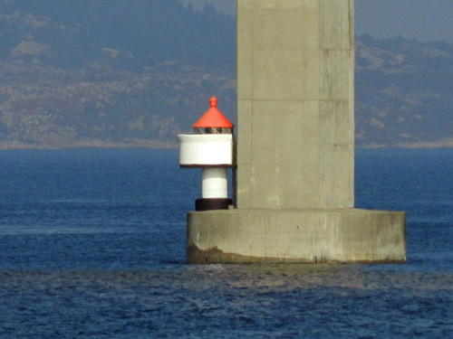
Date unknown. Active; focal plane 6 m (20 ft); white, red or green light, depending on direction, occulting twice every 8 s. 5 m (17 ft) concrete post with lantern and gallery. Lighthouse painted white; lantern roof painted red. Trabas has Boucher's photo (also seen at right) and the light is partly visible in Google's satellite view. Located on the foundation pad of the east pier of the Boknasundet Bridge, which connects the islands of Vestre Bokn and Austre Bokn on the E-39 highway about 20 km (13 mi) northwest of Stavanger. Accessible only by boat. Site open, tower closed. NF-119200; Admiralty B3416; NGA 2572.
Boknasundet (1)
1849. Inactive since 1912. 1-1/2 story keeper's house, originally with a semihexagonal lantern at ground level on one side. This building is reported to be in use as a private residence. Google has a street view and a satellite view. Located on Vestre Bokn a short distance north of the Boknasundet Bridge. Site closed (private property). ARLHS NOR-061.
Drivsund
Date unknown. Active; focal plane 9.5 m (31 ft); white, red or green light, depending on direction, 2 s on, 2 s off. 9 m (30 ft) concrete post with lantern and gallery. Lighthouse painted white; lantern roof painted red. No photo available but Bing has a distant satellite view. Located on a skerry in the entrance to the Drivsund, a sheltered bay at the south end of Bokn. Accessible only by boat. Site open, tower closed. NF-119700; Admiralty B3420; NGA 2580.
Klepp
Date unknown. Active; focal plane 18 m (59 ft); white, red or green light, depending on direction, occulting once every 6 s. 6 m (20 ft) lantern on a platform supported by four piles. Lantern painted white with a red roof, piles painted black. No photo available but Google has a fuzzy satellite view. Located on the southwestern peninsula of Bokn, marking the east side of the south entrance to the Karmsund. Accessible only by boat. Site open, tower closed. NF-119900; Admiralty B3422; NGA 2588.

Austboen Light, Bokn
photo copyright Michael Boucher; used by permission

Information available on lost lighthouses:

Notable faux lighthouses:

Adjoining pages: North: Haugesund Area | South: Eigersund Area

Return to the Lighthouse Directory index | Ratings key

Posted May 15, 2006. Checked and revised June 13, 2024. Lighthouses: 45. Site copyright 2024 Russ Rowlett and the University of North Carolina at Chapel Hill.